A hail suppression project dubbed RO-BERTA by the University of Applied Sciences, Rosenheim (Germany), has been selected the winner of the European Satellite Navigation Competition’s (ESNC) University Challenge. Judged by an international expert jury, the University Challenge is a special prize to reward innovative ideas emerging from Europe’s universities.
The Hail Navigator system is designed to reduce damage caused by hail. Based on the premise of suppressing the formation of hail by injecting silver iodide into clouds, Hail Navigator combines navigation with a precipitation reporting system that can guide pilots to optimal locations for hail suppression missions.
The system is complemented by weather observations (including precise times and locations) reported by local citizens via a smartphone app, which aids the validation of weather prediction models. These models constitute an important factor in deciding whether a hail suppression flight is necessary.
The project team was awarded the prize on October 23 in Berlin at the ESNC Awards Ceremony. More than 300 guests attended, representing the top European players in the navigation sector. In addition to cash, the prize includes support through the GNSS Research & Applications Centre of Excellence (GRACE) and a free ticket to the Munich Satellite Navigation Summit 2015.
“Winning this prize once again demonstrates that interdisciplinary cooperation is feasible and successful,” said Project Manager Peter Zentgraf. “The positive feedback the competition provides helps drive our many students to continue their dedicated work, which made it possible to reach our project goals.”
Summer 2014 will be one that the €6.3 billion (US$8.2 billion) Galileo GNSS programme will need to chalk down to experience and hope to move on from. At the time of my last EAGER column, we were starting to get a hint that one of the four in-orbit Galileo IOV satellites was not functioning. We now know that it has suffered a catastrophic power failure.
And in August, celebrations for a successful launch of the first two Galileo FOC satellites, named Doresa and Milena, quickly went sour when it became clear that they had suffered an anomaly during launch. And a very big anomaly at that.
We are still awaiting the preliminary results from the inquiry set up by the European Space Agency (ESA), the European Commission, and the rocket’s operator Arianespace. It is hoped that the results of the inquiry board will be available at the end of September.
ESA spokesperson Franco Bonacina informs me that on the satellite side, ESA’s teams at the ESOC control centre are investigating the possibility of partially raising or modifying the orbit of the two satellites, which are fully under control and in good health. They are also considering performing some software adaptations on board the spacecraft and at ground station level to try and make them “be seen” as operational satellites and able to provide operational services within the Galileo system. All this is still “work in progress” and it will take a few more weeks to be fully evaluated and put into practice.
So, what went wrong?
In the absence of firm conclusions from the inquiry, the rumour mill has been running at full throttle with the wide range of theories from cock-up to conspiracy.
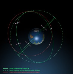
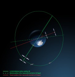
What we do know is that the Galileo craft were supposed to be launched by a Soyuz-Fregat rocket into a circular orbit 23,222 kilometres above the Earth and angled at 56 degrees to the planet’s equator. The initial launch from Kourou, French Guiana, on August 22 seemed to be smooth and nominal, but something went wrong in the final stages of the flight, and the two satellites were placed in an elliptical orbit varying from more than 2,000 kilometres too high to nearly 10,000 kilometres too low and also tilted by about 5 degrees from the intended plane.
Galileo orbits viewed side-on.
Galileo orbits viewed from above.
The most plausible explanation for the anomaly is that the Soyuz – Fregat upper stage suffered a control malfunction at some point before its final orbital injection burn. So although the rocket engine seems to have fired correctly, the craft wasn’t pointing in the right direction.
In fact, I am told that a likely mechanical root cause for the anomaly in the Fregat stage has been identified by the inquiry committee; however, more information is being gathered and further technical analysis is required to verify this.
Can anything be done?
Doresa and Milena do not have enough fuel on board to achieve the correct orbit for full Galileo operations.
Some interesting solutions have been proposed to launch a rescue mission to drag the errant satellites into their correct orbit, but that could be a slow, risky and expensive exercise. So could the satellites be useful in situ?
For most GNSS uses, the answer is probably no. Despite the fact that the satellites themselves are apparently working perfectly, in a safe state, correctly pointing towards the Sun, properly powered and fully under control of the ESA team, their elliptical orbit does not conform with Galileo’s standardized data format. For example, the value that represents the shape of the satellites’ orbit is too big to be expressed within the allotted bit limit for that parameter.
Marco Falcone, ESA’s Galileo system manager, says his team have been working intensely to determine if the satellites can be at least partially recovered. Among the considerations are the flight dynamics of moving the two spacecraft and the impact of the radiation they are experiencing in their current location, which can shorten the satellite’s lifetime. “It’s very dangerous for the satellite,” admits Falcone.
Another unknown is the timing performance of the satellites’ rubidium frequency and hydrogen maser given the relativistic effects of their orbit. Signal issues, such as the navigation message almanac, also must be considered before the FOC satellites can be introduced into operation, Falcone said.
Good for geoscience?
But according to fellow GPS World contributor Richard Langley of the University of New Brunswick, the situation is more hopeful for scientists wanting to use Galileo-derived data in their research. Quoted in an article in leading science journal Nature, Richard says that researchers tracking GNSS satellites via the IGS global network of ground stations combine that information with the timing data transmitted by the satellites themselves and could use it to measure changes in the position of points on the ground much smaller than the one-metre margin of error for standard navigation-system receivers. This level of precision is good enough to detect millimetres of movement in tectonic plates, for example.
This reminded me of a presentation by a team of Italian scientists I saw recently. The VADASE (Variometric Approach for Displacements Analysis Stand-alone Engine) project uses a novel strategy consisting of an algorithm able to perform real-time retrieval and estimation of displacement and waveforms based on high-frequency (1 Hz or more) carrier phase observations collected by a stand-alone GNSS receiver. The algorithm works with broadcast data (satellite clocks and orbits), requires very simple hardware, and has demonstrated potential application in real-world situations such as earthquake risk assessment (and related early-warning systems for tsunamis) and structural monitoring (see citations below). VADASE had already achieved a Galileo-only displacement solution using the four IOV satellites in orbit.
I contacted Gabriele Colosimo at Rome’s “Sapienza” University, and he confirmed that, although the satellites could not be used for direct gravimetric studies that require a very low orbit (below 1,000 km), the data from Doresa and Milena could be used to estimate displacements of GNSS receivers. He and the VADASE team think that a slight adjustment in their algorithm might be needed depending on the exact orbit parameters of the satellites, but the data would be useable without any significant change in orbit being required.
Gabriele also thinks that the data could be used to usefully contribute to studies in fields such as troposphere studies and GNSS reflectometry, as well as for geodynamic and seismic monitoring using GNSS.
Munich Masters
Hopefully the mystery of Doresa and Milena’s anomaly will have been resolved by October 23, when the 2014 European Satellite Navigation Competition (ESNC) awards ceremony takes place in Berlin in conjunction with the two-day Satellite Masters Conference.
But the real prize for the European GNSS community would be a full explanation of the recent Galileo issues, and how they are being resolved, and a clear statement and timeline on the future deployment and implementation of this flagship programme.
A bientôt – as they say in these parts
Citations
G.Colosimo, M. Crespi and A.Mazzoni, “Real-time GPS Seismology with a stand-alone receiver: A preliminary feasibility demonstration,” Journal of Geophysical Research, vol 116, doi: 10.1029/2010JB007941
M. Branzanti, G.Colosimo, M.Crespi and A.Mazzoni, “GPS near-real-time coseismic displacements for the great Tohoku-oki earthquake,” IEEE Geoscience and Remote Sensing Letters, vol 99, doi: 10.1109/LGRS.2012.2207704
2013 Galileo Master KINEXON offered a precise tracking and monitoring solution for sports and healthcare.
The European Satellite Navigation Competition (ESNC) is looking for services, products, and business innovations that use satellite navigation in everyday life. Prizes will be awarded by some of the most relevant institutional GNSS stakeholders, such as the European GNSS Agency (GSA) and the European Space Agency (ESA). In addition, partner regions from all over the world are hosting regional challenges.
The competition officially kicks off at the European Navigation Conference in Rotterdam on April 15, but submissions are being accepted from April 1 to June 30.
The prize pool of ESNC 2014 is expected to value about 1 million euros. Awards include cash prizes, business incubation, business coaching, patent consulting, technical support, access to testing facilities, prototype development, publicity, marketing support, feasibility studies, access to experts and public funding, and more.
In 2013, 25 partner regions offered prizes, and seven special prizes were provided by leading European industry and research partners. Entries will be assessed by the expert panels of the regions and special prize partners.
The overall winner — the Galileo Master — will be selected from among all regional and special prize winners by an international panel of high-ranking experts. The Galileo Master will be revealed at an awards ceremony in Munich, Germany, in October, and will receive an additional cash prize of 20,000 euros as well as the chance to realize the winning idea as part of a six-month incubation program in the region of his or her choice.
The ESNC is hosting a session at the CAPIGI conference in Amsterdam on April 3, jointly with the Copernicus Masters. The conference is dedicated to space technology for agriculture, focusing on the European Flagship programs Galileo and Copernicus. CAPIGI, the Community on Agricultural Policy Implementation and Geo-Information, is a network for geo-information experts active in agriculture.
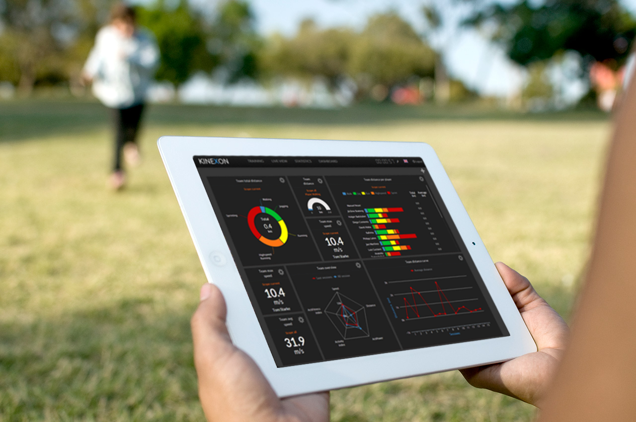
Online analysis of athletes’ tactical, technical, and physical capability is the focus of this year’s newly named Galileo Master, Kinexon GmbH.
The 10th European Satellite Navigation Competition (ESNC) recognized the best products, services, and innovations that facilitate the use of satellite navigation in everyday life. At the 2013 awards ceremony, prizes worth a total of about EUR 1 million were presented in 32 categories. The ceremony helped kick off the European Space Solutions conference, which is taking place November 5-7 at Alte Kongresshalle München.
ESNC 2013 gave participants from all around the world the chance to vie for any one of 25 regional prizes. In addition, topic-specific special prizes were sponsored by the following partners: the European GNSS Agency (GSA), the European Space Agency (ESA), the German Aerospace Center (DLR), and — for the first time this year — the European Patent Office (EPO) and Metaio GmbH. Students and research assistants were also encouraged to submit their ideas to the ESNC University Challenge.
Athletic analysis is playing an increasingly important role in modern sport training. The underlying idea — known as the Hawthorne effect — is simple: if you can measure your performance, you can also improve it. Following this principle, two research assistants from Technische Universität München (Germany) founded the company Kinexon GmbH at the ESA Business Incubation Centre Bavaria and developed a cloud-based solution for analyzing and visualizing training data on mobile devices.
Kinexon’s solution kits athletes out with a small, portable location sensor and feeds the resulting data into the cloud by means of a stationary base antenna. This enables users to track and analyze performance parameters and tactical movements down to the centimeter in real time.
In particular, however, it was the solution’s user-friendliness during training and relatively low cost (compared to the camera-based systems commonly seen today) that won over the international jury of experts in the European Satellite Navigation Competition. So far, the high price of such systems has limited their use to professional sport; Kinexon’s system will now give amateur clubs the chance to benefit from adding online analysis to their training activities, as well.
Along with the sport sector, this flexible satellite-based localization system also exhibits huge potential in tapping into further markets, including healthcare, logistics, and unmanned aerial vehicles (UAVs). “We’re pleased to be supporting Kinexon at ESA BIC Bavaria,” affirms Thorsten Rudolph, CEO of Anwendungszentrum GmbH Oberpfaffenhofen. The Kinexon system, the first version of which is set for market launch in November 2013, managed to edge out more than 400 other ESNC entries from nearly 50 countries.
Gerd Gruppe, member of the Executive Board, German Aerospace Center (DLR), conferred the EUR 20,000 grand prize on Kinexon GmbH founders Oliver Trinchera and Alexander Hüttenbrink.
“DLR sets great store in technology transfer,” Gruppe said. “After all, innovations form the basis of economic success and hold considerable potential for society. The ESNC has developed into a driving force behind the innovative use of satellite navigation technologies and a starting point for numerous successful start-ups in Germany, Europe, and the rest of the world.”
Winners of the 10th European Satellite Navigation Competition
In addition to the overall winner, the Galileo Master, the 10th European Satellite Navigation Competition rewarded Special Prizes in seven different categories and 25 prizes to regional winners.