The Galileo High Accuracy Service (HAS) was tested under real farming conditions to assess its performance and suitability for precision agriculture
The European GNSS Service Centre (GSC) of the European Union Agency for the Space Programme (EUSPA) partnered with Hemisphere GNSS and Case New Holland to test the suitability of the Galileo HAS service for precision agriculture.
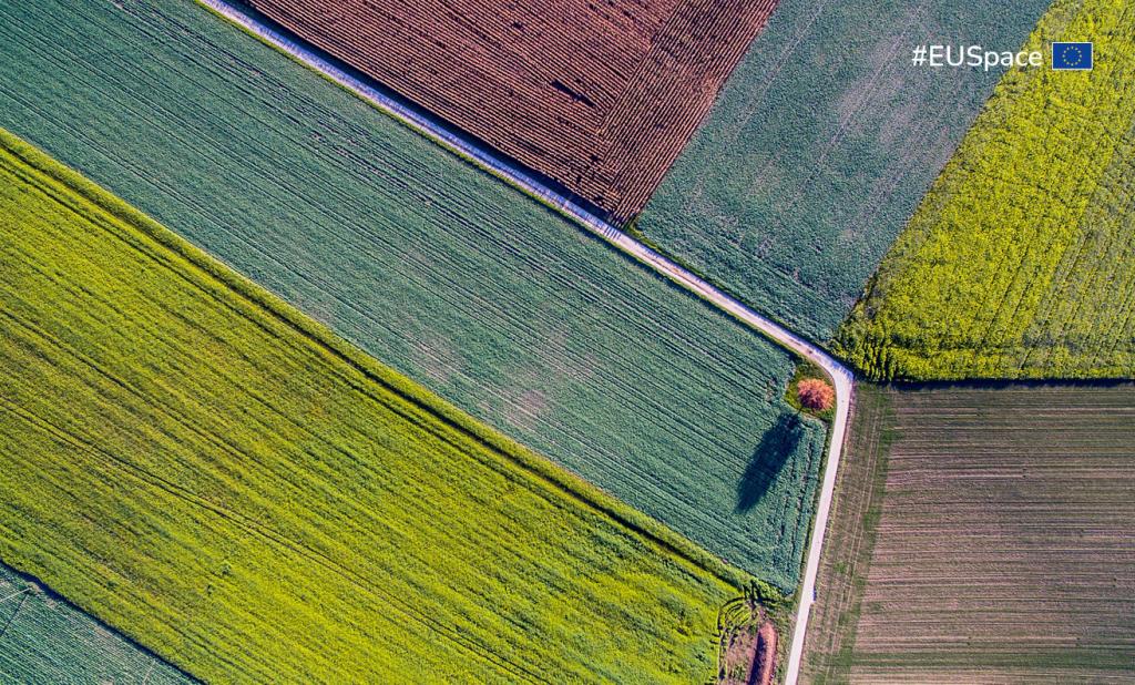
The tests were performed at the New Holland campus in Peñarrubias del Pirón, Segovia, Spain.
The working width used for the test was 2.55 m, while the test area covered approximately 20,000 m² with a perimeter of about 740 meters. During the three-hour test, the teams collected GNSS data to analyze the pass-to-pass and absolute accuracy metrics. Pass-to-pass accuracy is the relative precision of a guidance system to maintain a consistent distance between adjacent, parallel machine passes within a short timeframe (usually 15 minutes). It is crucial for reducing gaps and overlaps during planting, spraying, and harvesting.
Test campaign
The test campaign aimed at proving that the tractor consistently maintained the specified path accuracy during consecutive passes. This would show that HAS can optimize agricultural operations by reducing costs associated with overlaps (reworking the same area), leading to savings such as reduced fuel consumption, minimal input waste, and improved crop yield.
For the test setup, in addition to the onboard guidance system, an independent antenna was mounted on the tractor cab. This antenna was connected to two positioning solutions: one based on the Galileo HAS and another based on an RTK solution.
An RTK base station deployed for the occasion provided the rover with precise RTK corrections and enabled generating a “reference path” against which to compare the tested Galileo HAS, in this case based on corrections obtained directly from the signal in space (SIS) via the Galileo E6 band.
The driving was performed in automatic mode, with manual intervention required only for turning at the end of each pass. The autosteering system of the tractor would then automatically reconnect with the following path, as calculated at start-up.
Test results
The test began with the GNSS receiver in Cold Start mode, requiring it to obtain ephemerides and process satellite data before achieving precise positioning. The convergence time was calculated and is shown as the red area in the image below. The green area shows when the tractor started along the predefined paths and hence when the data was used for the pass-to-pass accuracy calculation.
Converge time and data set during the test. (Credit: EUSPA)
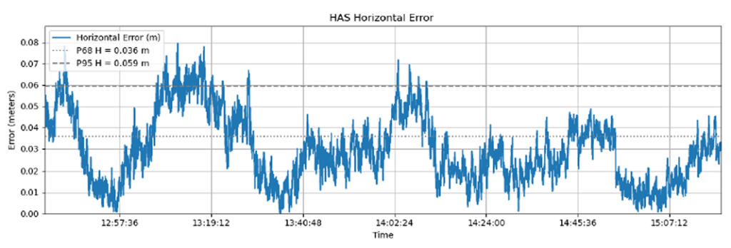
The data analysis showed that the Galileo HAS system consistently maintained horizontal errors of 3-6 cm.
With a 95% horizontal error of 5.9 cm and its maximum value below 8 cm, the error remains well below the 20 cm HAS accuracy target.
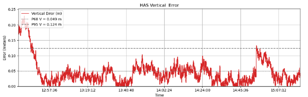
As regards the vertical axis, the 95% vertical error was 12.4 cm, with its maximum value below 25 cm, (remaining well below the 40 cm HAS accuracy target).
Galileo HAS signal vertical error. (Credit: EUSPA)
The horizontal error of the HAS service relative to the RTK reference baseline is shown in the following figure.
Galileo HAS signal horizontal error. (Credit: EUSPA)
Regarding the pass-to-pass accuracy, the analysis shows an overall pass-to-pass accuracy of 1.18 cm, demonstrating highly stable performance throughout the test period.
Year-to-Year accuracy was not part of this testing campaign but will be analysed in the next testing campaign.
Galileo HAS potential confirmed
The Galileo HAS service is an open, standardized correction service distributed directly via Galileo E6 or the internet (with global coverage) and the test campaign results confirm its potential to generate savings to farmers in terms of fuel consumption, fertilizers, seeds and other inputs, by reducing overlap in field operations.
The European Union Agency for the Space Programme (EUSPA) has awarded GMV a six-year framework contract to upgrade the European GNSS Service Centre (E-GSC) infrastructure. The contract is valued at €35 million ($39 million).
The E-GSC is critical to the European Union satellite navigation program’s infrastructure. Its primary mission is to provide a unified interface for users of the Galileo and EGNOS systems, offer supporting services, and contribute to delivering new Galileo services. The E-GSC’s various functions include distributing data from the European Union navigation satellite services to the user community and supporting the growth of the global Galileo applications market.
Originally designed to be part of the European GNSS infrastructure and to provide a unified interface between the Galileo system and its users, the E-GSC has expanded its role over the years to become a key component in delivering services enabled by the European Union Space Programme.
The new framework contract aims to advance the E-GSC’s capabilities, enabling it to take on increased responsibilities. This includes creating new services for users, enhancing their experience, integrating service delivery aspects of Galileo and EGNOS, and supporting the development of additional services.
GMV is leading a consortium that features Indra as the main industrial partner, along with prominent companies such as Spaceopal, ESSP, Alten, the Universitat Politècnica de Catalunya (UPC) and the Universidad Autónoma de Barcelona (UAB).
Under the supervision of EUSPA as Contracting Authority, GMV will oversee project management and IT infrastructure development through all stages, including definition, implementation, validation and integration into the Galileo ground segment. GMV will also develop the software components necessary for delivering new data and signal authentication services for Galileo satellites.
In 2022, the Galileo GNSS continued to provide the world’s most precise satellite navigation information, to a user base that stands at more than 3.5 billion worldwide. Furthermore, provided services continue to improve and expand, with plans for high-accuracy positioning and signal authentication now reaching fruition.
The European Union Agency for the Space Programme (EUSPA) and the European Space Agency (ESA) continue to enjoy an effective collaboration on the many development, deployment, and evolution activities of the Galileo Programme — each according to their respective responsibilities for service provision and system development with the European Commission (EC) acting as the program manager.
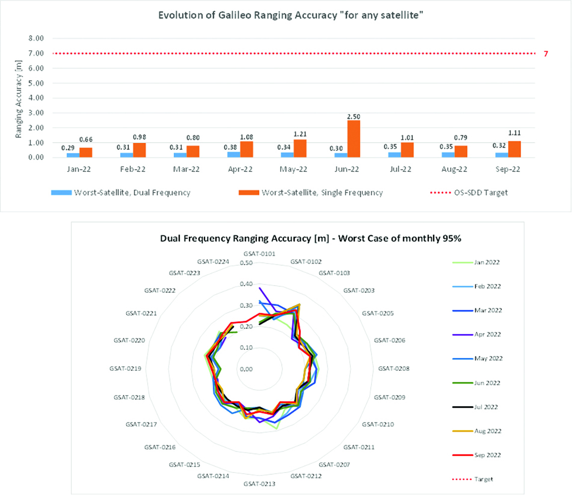
Ranging accuracy performance from January to September 2022.
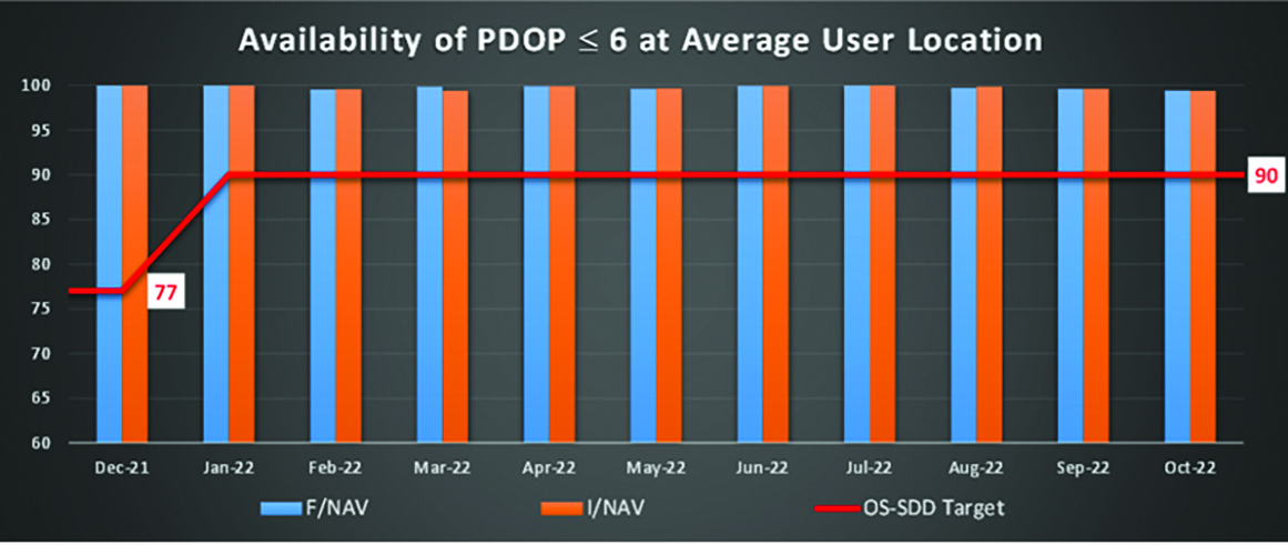
Positioning-related MPLS from January to October 2022.
New Services Launched in 2022
Excellent Performance
Service delivery operations and maintenance of operational systems are managed by EUSPA, which supervises many contracts that carry out the day-to-day activities from dedicated control and monitoring centers throughout Europe. In 2022, Galileo timing, navigation, and SAR/Galileo services were delivered with excellent performances that continue to exceed the formal declarations for minimum performance levels (MPL), which were increased in January, both in terms of absolute accuracy and overall service availability. The entry into service of two additional satellites in May and August, have further consolidated the overall service availability to end users.
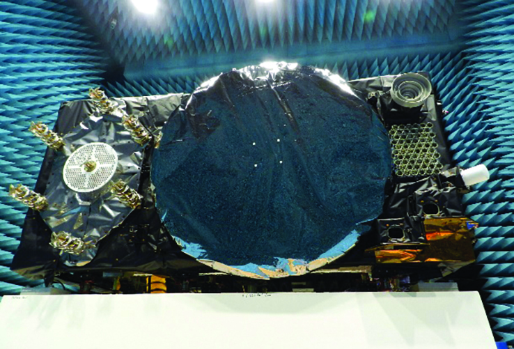
Galileo FOC Batch 3 satellite under testing.
Expansion of Service Portfolio
The service provision teams have been able to focus on improvements to, and expansion of, the service portfolio.
The I/NAV improvement will positively impact end users by enabling a faster time to first fix, and updates to the data validity status flags will lead to better protection of users against expired navigation data. These changes are implemented in updates of the onboard software of the satellites being rolled out across the constellation. At present, seven operational satellites have been successfully updated; the complete software upgrade campaign is planned to be completed this summer.
Galileo’s new High Accuracy Service will provide free precise point positioning (PPP) corrections, in the Galileo E6-B data component and by terrestrial means, for Galileo and GPS (single and multi-frequency) to achieve real-time user position improved by up to 10 times. The infrastructure to support an initial service (Phase 1) is nearing completion, and the formal declaration of the service capabilities is planned for early this year.
To provide users with a method of authenticating the received Galileo signals, especially the satellites ephemerides and the Galileo timing parameters, the new Open ServiceNavigation Message Authentication (OSNMA) service enables a receiver to confirm that a navigation message originated from the EU Galileo infrastructure. Many application areas are expected to benefit from this capability, including smart tachographs, telematics and logistics, UAVs, location-based services, and timing services. Having successfully demonstrated the technology behind the service in 2022, including a public observation phase, the roll-out of the Initial Service is planned to take place by the end of the year.
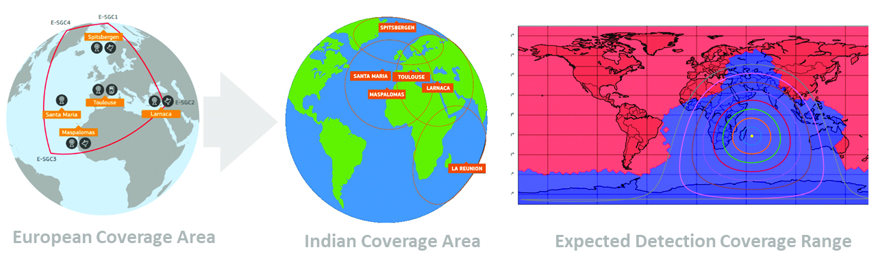
A fourth Medium Earth Orbit Local User Terminal (MEOLUT) in La Réunion will extend the SAR/Galileo Forward Link Service Coverage Area over the Indian Ocean as part of the SAR/Galileo full operational capability (FOC) declaration expected in the first quarter of 2023. The Cospas-Sarsat commissioning of this new station was completed in September 2022, and operational data is already being distributed to Cospas-Sarsat.
Reference documents for the above services can be found at the EUSPA European GNSS Service Centre website, including technical notes, interface control documents and service declaration documents.
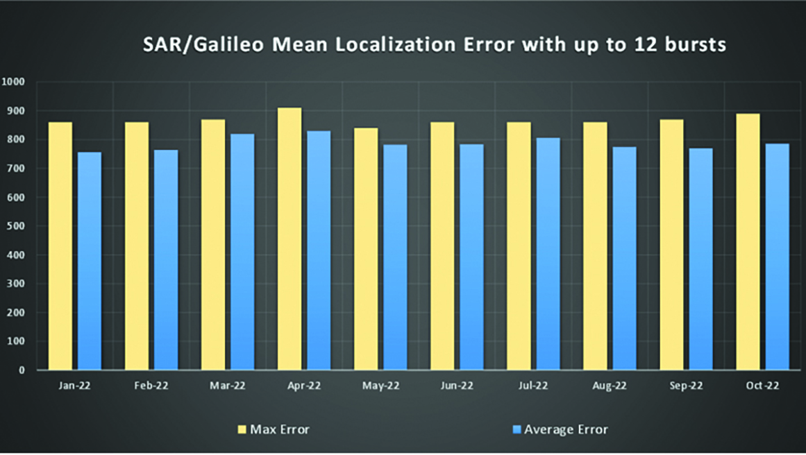
SAR/Galileo-related metrics from January to October 2022.
Extension of the SAR/Galileo Forward Link Service Coverage Area over the Indian Ocean.
FOC Infrastructure Development Nears Completion
Satellite Production
The production of the third batch of Galileo FOC satellites advanced further in 2022 with the completion of the environmental tests and the system compatibility test campaigns at the European Space Agency Test Centre in Noordwijk, The Netherlands. After 10 years of successful testing, on Oct.18, 2022, the last Galileo FOC satellite (flight model number 34) left the test center to return to the premises of the satellite manufacturer, OHB Systems, in Germany. Testing of the remaining 10 satellites has confirmed that they have been correctly built and will perform well in orbit. The acceptance review of the last couple of satellites will take place this summer.
At the beginning of 2023, the plan is to start in-orbit testing of a quasi-pilot signal on the E5 frequency using the Galileo GSAT201/202 satellites in elliptical orbit. The provision of a signal offering coarse acquisition in Galileo E5-A/GPS L5 can be a distinguishing feature for Galileo with respect to all other constellations to further improve the capability to acquire the E5 signal at low complexity. Following in-orbit testing, the strategy for roll-out of this capability will be assessed with the involvement of receiver manufacturers.
New SAR Galileo MEOLUT facility in Réunion island.
Access to Space
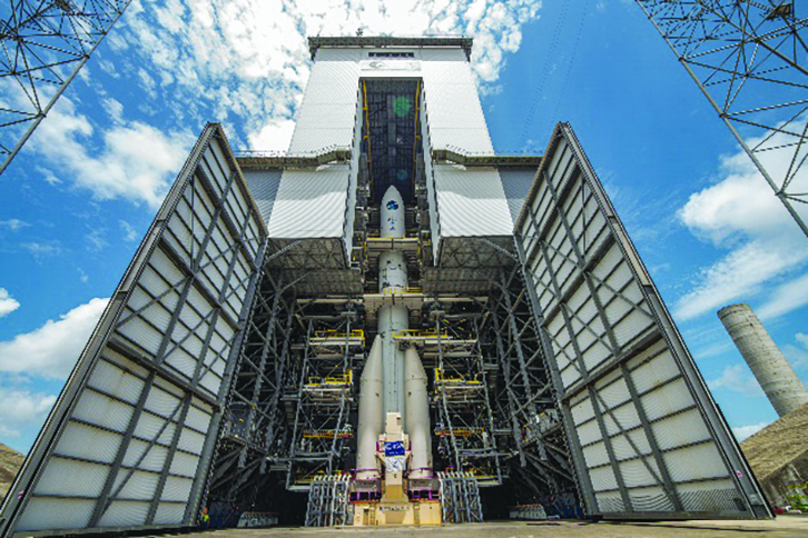
The discontinuation of Soyuz launch services from the Kourou Space Centre in French Guiana, because of the Russia-Ukraine conflict, has caused delays in the two Galileo launches that had been planned for 2022. The Launch 12 campaign had to be interrupted and in March 2022 the FM25 and 26 satellites were put in storage at the Kourou launch base, then returned to Europe in November.
Ariane 6 is the baseline launcher for Galileo satellites to ensure European independent access to space. The remaining Batch 3 satellites will be launched with the Ariane 62 launcher vehicle, the two strap-on solid booster variants of Ariane 6, now undergoing the final stages of development led by prime contractor Ariane Group. Ariane 6’s maiden flight is scheduled to take place in the fourth quarter of 2023.
Ground Segment
An upgrade of the ground control segment, in charge of command and control of the satellite constellation, is being developed by the industrial consortium led by GMV. The upgrades will address resolution of hardware and software obsolescence including cyber security, operability improvements, and a security monitoring overlay.
With the planned increase in the number of satellites in orbit, an additional telemetry tracking and control facility (TTCF) is being deployed in Kourou leading to seven operational TTCF stations in early 2023.
The ground mission segment, in charge of navigation control, is undergoing a complete technological refresh, including hardware/software virtualization performed by an industrial consortium led by Thales France. This upgrade will provide additional robustness, including a system extended contingency mode resilient to outages lasting up to seven days and a new state-of-the-art cyber security monitoring system. It will also provide ranging authentication through encrypted codes on the E6-C signal component for the implementation of the Commercial Authentication Service. Global coverage will be further increased with the introduction of two Galileo sensor stations in Wallis (Pacific Ocean) and Bonaire (Caribbean Sea), for a total of 15 sites around the globe.
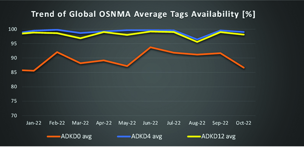
OSNMA-related metrics from January to October 2022.
G2G Development Started
Galileo’s second generation (G2G) will introduce many innovative technologies to offer unprecedented precision, robustness, and flexibility.
2022 was a key year for the evolution of G2G activities with the fast development cycles of the first batch of G2 satellites, beginning development of the associated G2G in orbit validation (IOV) ground segment and system test beds, and the consolidation of the G2G final system capabilities — including the coordination of the mission/service roadmaps with the EC, EUSPA, and the EU Member States delegates.
Ariane 62 launcher.
G2G Satellite Manufacturing
From the satellite development point of view, the two parallel contracts to develop and manufacture each of the six G2G batch one (G2SB1) satellites are progressing in a fast development environment, with the first hardware units ready for integration and testing.
Following the completion of preliminary design review, these two contracts (for six satellites each) are preparing for unit-level validation/testing, which will lead to the critical design review.
These satellites will provide the following key innovations:
Reconfigurable fully digital navigation payload
Point-to-point connection between satellites by inter-satellite-link for command and control, and ranging functionalities
Electric propulsion for orbit-raising capabilities
Advanced jamming and spoofing protection mechanisms to safeguard.
The Galileo signals will improve with:
On-board authentication capabilities
Increased ground-to-space data rate
Improved time reference (number of clocks and advanced clock monitoring functions).
G2G IOV Procurements
2022 was also the year in which two key events took place with respect to G2G in-orbit validation (IOV) ground segment and system test bed procurements:
Finalization of the procurement cycle, now in the final evaluation/award phase, to be kicked off in the first quarter of this year
Confirmation of the IOV design through different coordinated actions with the EC and EUSPA, including the G2 system preliminary design review.
The contracts will provide Europe with the following capabilities:
G2SB1 satellite launch and early orbit phase, in-orbit testing and enhanced legacy services provision
G2 new capabilities in-orbit validation, including prototyping and validation of all the novel technologies that can exploit the full capabilities of the G2SB1 satellites.
Eleven contracts will be issued to manage in synchrony all the G1 and G2 assets for the coming years:
G2 IOV ground control segment (G2 GCS) for satellites monitoring and control
G2 IOV ground mission segment/secured facility (G2 GMS-GSF) for the production, dissemination and monitoring of all enhanced legacy services and the dissemination of new G2 advanced capabilities for validation
G2 IOV security monitoring (G2 SECMON), for the cyber/security monitoring of the system
G2 filling device (G2 FD), to ensure proper initialization of system assets
G2 system test bed (G2STB), to generate and monitor new G2 capabilities for validation of the G2G mission/services
G2 PRS test bed (G2PRSTB), similar to G2 system test bed but focused on advanced PRS capabilities for validation purposes
G2 security chain (G2SC), a test bed to ensure proper satellite-ground segment qualification before launch
Four system engineering support contracts (G2 SETA), where the main GNSS technical experts from different industries in Europe provide their support to ESA and EUSPA in their different fields of expertise.
These contracts are complemented by a significant set of system research and development and test tools, such as test user receivers and radio frequency constellation simulators.
G2G batch number one (G2SB1) satellites.
Galileo Second Generation System PDR
The Galileo Programme is not only focusing on short-term G2G development activities, but also looking forward to the future in terms of the consolidation and definition of G2G final operation capabilities. During the second half of 2022, more than 200 public representatives from the EC, EUSPA, ESA and Member States held countless meetings in the frame of the G2G system preliminary design review, which concluded in early December 2022.
As part of this review, the long-term implementation (G2G in orbit capability, or IOC, and final operational capability, or FOC) was reviewed and an agreement was reached on future steps. The evolution of Galileo capabilities will not only provide better services through advanced technical solutions, but will also ensure continuity of service and enhanced backward compatibility for first-generation legacy users.
Conclusions
The efforts of ESA and EUSPA continue with the aim of providing users continuous and stable services and evolving space and ground infrastructure to maintain Galileo competitiveness with the other global navigation satellite systems.
For analogous updates on the other three GNSS constellations, please see:
Galileo and EGNOS were the focus of attention at a special workshop at this year’s Intergeo in Stuttgart, which took place in September. Intergeo is the world’s leading conference and trade fair for geodesy, geo-information and land management.
Intergeo provided an opportunity to give an update on the status of the Galileo and EGNOS programs and to present user case studies at a special workshop focusing on the geomatics market.
In his presentation at the conference, Eduard Escalona, Market Development Innovation Officer at the European GNSS Agency (GSA), stressed the key role of GNSS.
“GNSS is a cornerstone in many areas: It is a fundamental element for cadastral surveying, in the construction sector, in mining, land surveying and mapping activities, for all geographic information systems (GIS), for infrastructure monitoring and for marine surveying. For all of you who are working in these and many other areas, Galileo is now helping to provide the GNSS services you need,” he said.
Dual-frequency boosts market
The European GNSS programs, Galileo and EGNOS, continue to move forward in terms of adoption by the professional market and among general users, thanks in no small part to the development of dual-frequency capability.
Traditionally, mobile, location-based applications have been powered by single-frequency GNSS receivers operating under stringent battery-power and footprint constraints. With a dual-frequency chipset, these devices now benefit from better accuracy, ionosphere error cancellation, improved tracking and better multipath resistance.
Galileo is leading the way in the area of dual-frequency signal delivery, now with more dual-frequency operational satellites in orbit than any other GNSS system. Market uptake of Galileo receivers has been impressive; in addition to the geomatics-related areas of particular interest to the Intergeo public, dual-frequency GNSS chipsets are also appearing in the automotive sector, where connected cars and autonomous vehicles present a clear and pressing need for accurate and reliable positioning information.
New services to come
“To date, more than one billion Galileo-enabled devices have been sold,” said Escalona, “but Galileo isn’t standing still, waiting. We are proposing new services to appear in the coming years.”
These include the much-anticipated High-Accuracy Service (HAS) and a new Authentication Service. “The HAS will be a free, globally available service providing an accuracy of 20 cm, with PPP [Precise Point Positioning] corrections,” Escalona said.
Meanwhile, the Authentication Service (OS-NMA) will provide protection against jamming, spoofing and meaconing on the E1B signal and a separate Signal Authentication Service (SAS) will provide an even higher level of protection on the E6 signal.
“EGNOS is currently working with GPS, but of course we are looking forward to augmenting Galileo in the near future,” said Sergio Cabrera Bona, EGNOS Service Adoption Tools Engineer at the European Satellite Services Provider, whose core activities comprise EGNOS operations and service provision.
“GNSS is critical in all of these fields, whether it is mapping and GIS, farming, forestry, thermal pictures, management of natural terrains,” Cabrera said. He listed other areas, including management and inspection of utilities, power networks, water supply, telecoms, drones, inventory, surveying, field campaigns and determination of perimeters in agriculture as areas where GNSS plays a key role.
“It is not possible to mention all of the activities where you need reliable positioning. What you have to know is that with EGNOS augmentations you already have a horizontal accuracy below one metre and a vertical accuracy below two metres, so this is a very good accuracy,” he said.
There is much more that could potentially be done right now, Cabrera explained. “Most of the professional equipment is already EGNOS-enabled, but in practice users do not always configure their equipment correctly to exploit this capability. EGNOS adoption and support is going ahead full speed, but in the GNSS device market, many users still do not know they can use EGNOS. So the education process remains an ongoing effort,” he said.
Cabrera explained that the EGNOS user support website can be an important part of this educational drive on the top of the help desk. “We have very interesting tools and resources available online. For example, we will have a new EGNOS usability map available very soon on the website. With this tool you will be able to easily see the current availability of EGNOS signals in your location, which will be very useful especially in urban environments, for example. We also have many user support services and there is a new mobile app coming, so please visit our website and take advantage of EGNOS. It is there for you.”
Introducing the GSC
Galileo services improvement expert Pedro Gómez Martínez informed participants about the European GNSS Service Centre (GSC), defining both the concept of operations as well as the procedures necessary to provide the services that the GSA offers to Galileo users.
“The European GNSS Service Centre is the single interface between the infrastructure and users of the Galileo open services, commercial service and search and rescue service (SAR),” said Gómez. “So the GSC is a center that provides experts, know-how, evaluation of capability, distribution of information and support for the provision of value-added services provided by the Galileo system.”
The GSC website is a core resource for Galileo users, Gómez said, reporting real-time system status and incident notifications, with a bank of key documents and a full-time help desk. “It is very important for us that this is a two-way interactive service that includes your feedback. We need you to report any incidents that you might experience related to the product, service and data provision. We are very interested in user satisfaction, and we want to know how you respond to improvements. And of course, in general, we are here to promote GNSS in all its forms, in all areas, for all users.”
The GSC launched a new version of its website in the run-up to the InterGEO event. “More than ever we are making it easier for you to engage in dialogue with us and to provide your feedback. This is very important to us with new services coming up in the future,” Gomez said.
Research fundamentals
“One of the very important responsibilities of the GSA is the management of a number of EGNSS research and development programmes,” said Eduard Escalona. “We have Horizon 2020, the European Union’s research Framework Programme. There we have a final call for proposals coming up in November, with a deadline in March 2020. The GSA also is overseeing the Fundamental Elements programme, which is funding research specifically targeted at developing Galileo-enabled chipsets, receivers and related technologies.”
To illustrate Escalona’s point, the presentations featured EU-funded GNSS-related research projects leveraging the accuracy and integrity offered by Galileo. Pere Molina of Geonumerics presented the MapKite project. Funded under Horizon 2020 and now completed, MapKite integrates an unmanned aerial system (UAS) and a mobile mapping aystem (MMS) for simultaneous capture of geo-data from the air and from the ground. Molina showed data from a successful corridor mapping exercise run using the MapKite system.
The document contains the Galileo E6-B and E6-C codes specifications, including primary and secondary codes and their assignment to satellites, which is necessary for manufacturers who are developing Galileo E6-B/C enabled receivers.
The technical note represents the first step for these forthcoming Galileo services: high-accuracy service (HAS) and commercial authentication service (CAS) on E6-B/C signal.
The European Commission has published a new release 1.2 of the Galileo Open Service Signal In Space Interface Control Document (OS SIS ICD v1.2). The document provides the information needed by receiver and chipset manufacturers, application developers and service providers to process and make use of the open signals generated by the Galileo satellites.
The OS SIS ICD contains the publicly available information on the Galileo Open Service Signal In Space, specifying the interface between the Galileo space and user segments. The Galileo user segment is of particular interest to the European GNSS Agency (GSA), which has been delegated responsibility for the program’s service provision by the European Commission.
In fulfillment of this role, the GSA is developing the European GNSS Service Centre (GSC), which provides the single interface for information and help to users of the Galileo Open Service (OS).
Once fully developed, the GSC will operate on a 24/7 basis and offer a range of services, including hosting the Galileo User Helpdesk, providing the interfaces between the Galileo System and OS users, and hosting a center of expertise for OS service aspects.
The OS SIS ICD is a key document that provides the information required by receiver and chipset manufacturers, application developers and service providers to be able to process the Open Service signals generated by the Galileo satellites. In particular, the document specifies:
Galileo signal characteristics
Characteristics of Galileo spreading codes
Galileo message structure
Message data contents
The latest version is based on feedback from receiver manufacturers and other stakeholders received during an extensive public consultation in 2014.
The GSA further highlights the importance of this document for the development of receiver technology, which is the key enabler for translating Galileo signals into useful services. Over the past several years, the GSA has been engaged in open dialogue with chipset and receiver manufacturers, paving the way for Galileo to be fully integrated into a new generation of receivers and ensuring its signals will provide a wide array of new applications and services that directly benefit European citizens.
In addition to a number of minor editorial improvements including corrections and clarifications, an annex with numerical examples of FEC coding and interleaving has been added and the license agreement has been revised and simplified.
The document now refers to a companion document, “Ionospheric Correction Algorithm for Galileo Single Frequency Users,” containing details on the ionospheric model used for Galileo. The E1-B, E1-C and E5 Primary Codes in Annex C are no longer included in the paper version, but are available in the electronic version of the ICD.