NASA is soliciting research on remote sensing techniques that use GNSS for studying the Earth’s environment.
Specifically, the announcement says NASA “seeks innovative approaches to the development of Global Navigation Satellite System (GNSS) remote sensing techniques and algorithms to study the Earth’s environment from the ionosphere to Earth’s interior.” The announcement says NASA is seeking to emphasize the use of reflected GNSS signals for the characterization of the Earth’s surface and mitigation of natural hazards.
Notices of Intent are requested by January 20, 2015, and the due date for proposals is March 20, 2015.
NASA solicits research through the release of various research announcements in a wide range of science and technology disciplines. NASA uses a peer review process to evaluate and select research proposals submitted in response to these research announcements. NASA says that researchers can help achieve national research objectives by submitting research proposals and conducting awarded research. Visit the announcement page for details.
Space News is reporting that the U.S. government has alerted the European Union that any preferential treatment the EU gives to its Galileo positioning, navigation and timing network will likely violate World Trade Organization (WTO) agreements signed by the United States and the 28-nation EU.
According to a report by Peter B. de Selding, U.S. government officials voiced concerns that the EU is weighing equipment mandates for aviation, car-accident reporting and emergency-call regulations that could unfairly tip the scales in favor of Galileo to the detriment of U.S. GPS-enabled hardware.
In a presentation to the 9th Meeting of the International Committee on GNSS, held Nov. 10-14 in Prague, a senior GPS official said the United States and the EU have signed a wide body of satellite navigation agreements designed to promote open market access and interoperability.
European Commission officials have said in recent months that they are still weighing how to stimulate Galileo use.
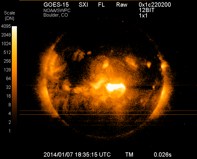
Image of the sun on Tuesday, Jan. 7, 2014, from the Solar X-Ray Imager on NOAA’s GOES satellite, taken just after the maximum emission of a solar flare. The eruption came from the middle of the sun and is directed toward Earth. This is the largest solar flare so far this year.
Forecasters at NOAA’s Space Weather Prediction Center said the sun’s coronal mass ejection (CME) that reached Earth on Jan. 9, unsettled the geomagnetic field but did not cause storm conditions to be reached due to the weak magnetic field. While there is still a chance we could see some geomagnetic storming, that threat is greatly diminished. The Space Weather Prediction Center is a division of the U.S. National Oceanic and Atmospheric Administration.
The sunspot in Region 1944 that produced the eruption at 1:32 p.m. EST Tuesday, January 7, has had no significant additional flaring and shows signs of decay.
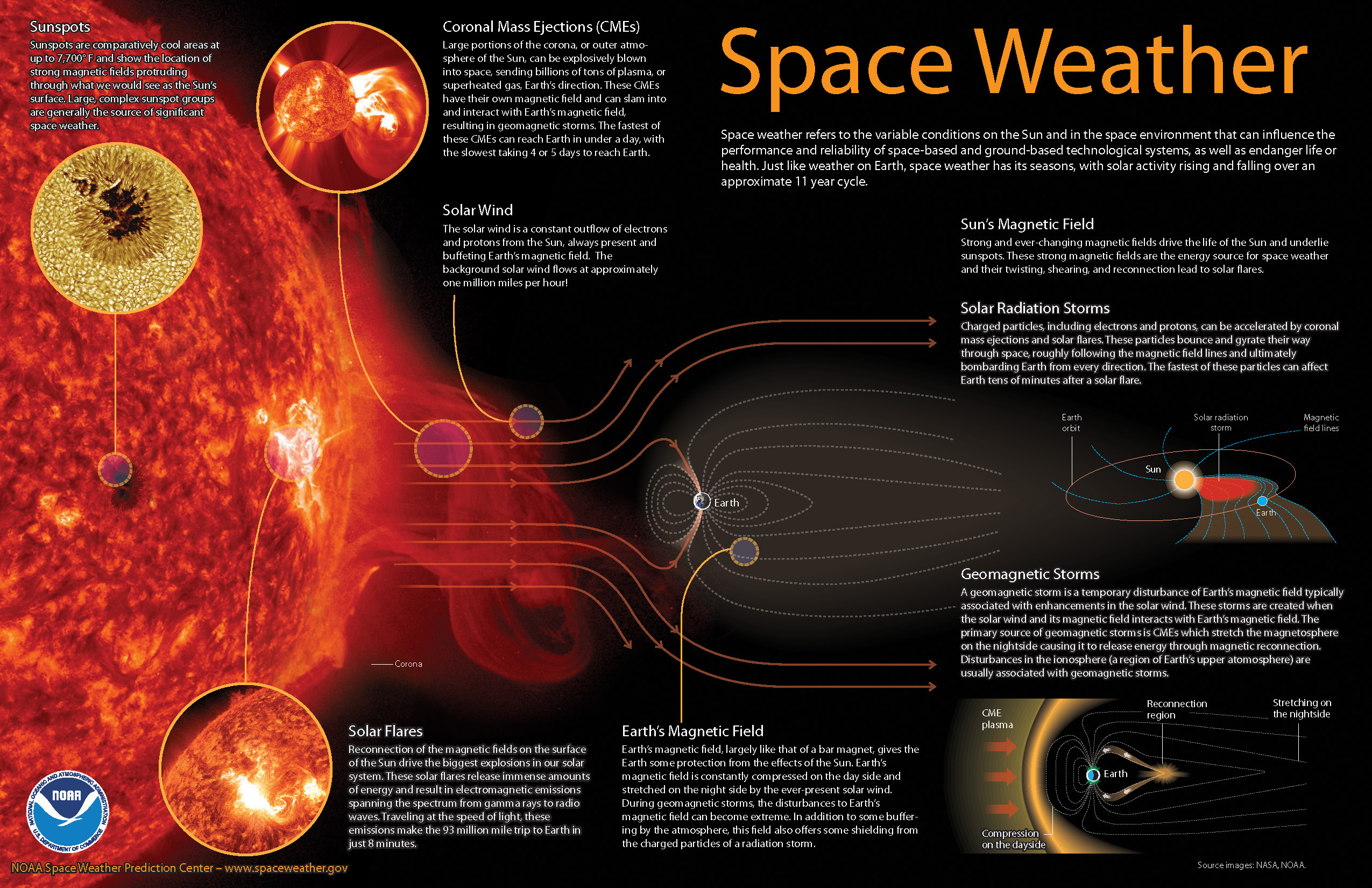
How space weather affects real-time technology
Economies around the world have become increasingly vulnerable to the ever-changing nature of the sun. Solar flares can disrupt power grids, interfere with high-frequency airline and military communications, disrupt GPS signals, interrupt civilian communications, and blanket the Earth’s upper atmosphere with hazardous radiation.
Monitoring and forecasting solar outbursts in time to reduce their effect on space-based technologies have become new national priorities. And NOAA’s Space Weather Prediction Center (SWPC), part of NOAA’s National Weather Service, is the nation’s official source of space weather forecasts, alerts, and warnings.
Space weather explained (source: NOAA).
Monitoring the Sun
To monitor events on the sun, SWPC staff utilize a variety of ground- and space-based sensors and imaging systems to view activity at various depths in the solar atmosphere. A worldwide network of USAF-sponsored optical observatories also provides space weather forecasters with detailed, plain-language information about activity in and around sunspot groups, as well as other areas of interest on the sun.
Space weather forecasters also analyze the 27-day recurrent pattern of solar activity. Based on a thorough analysis of current conditions, comparing these conditions to past situations, and using numerical models similar to weather models, forecasters are able to predict space weather on times scales of hours to weeks.
With effective alerts and warnings, NOAA is helping to minimize the hazards of space weather on technology. For example, satellite operations can be adjusted, power grids can be modified, and polar flights can be rerouted.
On August 30, QinetiQ and Rockwell Collins demonstrated the first joint satellite navigation positioning using live signals from the encrypted governmental services from the U.S. Department of Defense (DOD) GPS Precise Positioning Service (GPS-PPS) and the new European Galileo Public Regulated Service (PRS). The signals on GPS L1 and L2, together with Galileo PRS L1A and E6A, were processed and combined to form multi-frequency, multi-constellation position fixes.
Positioning, navigation and timing (PNT) services provided by GNSS, such as GPS and the forthcoming Galileo system, are essential to underpinning both commercial and economic activity (the EC estimates 6-7% of the developed world’s GDP) and the delivery of governmental responsibilities including the safety and security of citizens.
GNSS systems such as GPS and Galileo make use of very low power signals and are subject to inadvertent interference, deliberate jamming and spoofing (where an attacker generates a false signal masquerading as a valid one to mislead a user receiver). Attacks on GNSS may range from low-level criminal nuisance (a delivery driver stopping their employer tracking them), enabling theft of high-value vehicles fitted with trackers, through to state-sponsored attacks. This is potentially a significant concern for a wide range of governmental users including law enforcement, security and emergency services, critical national infrastructure, transport and defense users. The use of multiple independent, secured navigation services provides significant improvements to navigation robustness and, along with other measures, offers substantial counters to these threats.
“This has been our first opportunity to explore how secured navigation services on GPS and Galileo can be used together to provide users with critical reliance on PNT with robust and continuous navigation services,” Nigel Davies, Head of QinetiQ’s Secured Navigation Group said. “QinetiQ is proud to be a key, long-term contributor to the Galileo Programme, having been working closely with the European Space Agency (ESA), the European GNSS Agency (GSA), European industrial partners and European Member States since 2003. QinetiQ and Rockwell Collins wish to thank ESA, the EC and GSA for support in accessing Galileo, as well as the UK Space Agency, UK Satellite Applications Catapult and the UK MOD for their support.”
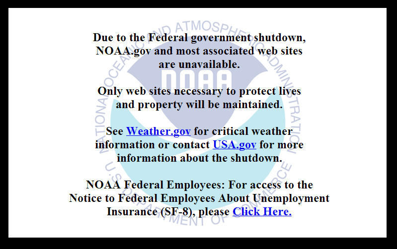
On October 1, 2013, the U.S. federal government shut down and furloughed 800,000 non-essential workers. While services considered essential remained active, those considered non-essential services, like the National Geodetic Survey’s Online Positioning User Service (OPUS), were shutdown. OPUS is a free, online GPS post-processing service. If you try to access www.ngs.noaa.gov, the following screen will be displayed:
Photo: NOAA
For those of you who rely on OPUS for GPS post-processing, now is a great time to try one of the other seven online post-processing services available and not subject to the U.S. federal government. Yes! I wrote seven, and the results from those seven are comparable to OPUS. The other seven, free online GPS post-processing services are:
CSRS-PPP: Canadian Spatial Reference System, Natural Resources Canada
My colleague Mark Silver, creator of the X90-OPUS receiver I wrote about a few months ago, embarked on an effort to run test data through each of the online post-processing services to demonstrate that there are free, online GPS post-processing services available worldwide that produce results comparable to OPUS. The following report is the result of his efforts:
A Comparison of Free GPS Online Post-Processing Services
By Mark Silver
You are probably familiar with the National Geodetic Survey’s OPUS suite of online post processing tools (OPUS-Static, OPUS-Rapid Static and OPUS-Projects.) These services are capable of producing centimeter-level positioning from static GPS observations. What you may not realize is there are at least six viable alternatives to OPUS.
All are free, easy to use, provide world-wide coverage, and generate surprisingly similar results.
Since each uses a unique baseline tool and processing strategies they form an excellent reality check against each other.
IGS orbits and the IGS permanent CORS arrays are used by many of the services, however some use proprietary equipment arrays and orbit products that provide additional redundancy.
How comparable are these services? Which one is the best?
Criteria for Comparing
Comparing results is a difficult proposition:
The true/correct answer for any site is unknown.
What grading scale should be used? Should elevation differences be weighted differently than horizontal differences?
Should the peak-to-peak range or the standard-deviation be prized?
Should comparisons be made on long 24-hour data sets or short 2-hour occupations?
Is a single data set sufficient for a meaningful comparison or are multiple data sets preferable?
Should a service be ‘thrown out’ of consideration because the solutions are substantially different from the mean?
The answer to all of these questions is “it depends.” Your evaluation will depend on your specific application.
For this evaluation, the following rules governed the data set selection:
Choose a site known to be stable with a clean EMI environment.
Use 24-hour observation sets to enable ‘best case’ processing.
Use a sufficiently large data set, 32-consecutive days, to expose trends.
Choose a time period, 90-days in the past, so precise orbits are available to reduce ephemeris effects.
Only consider GPS data.
Use default settings for every option on each processing service.
Scoring
This would not be as interesting without a little competition.
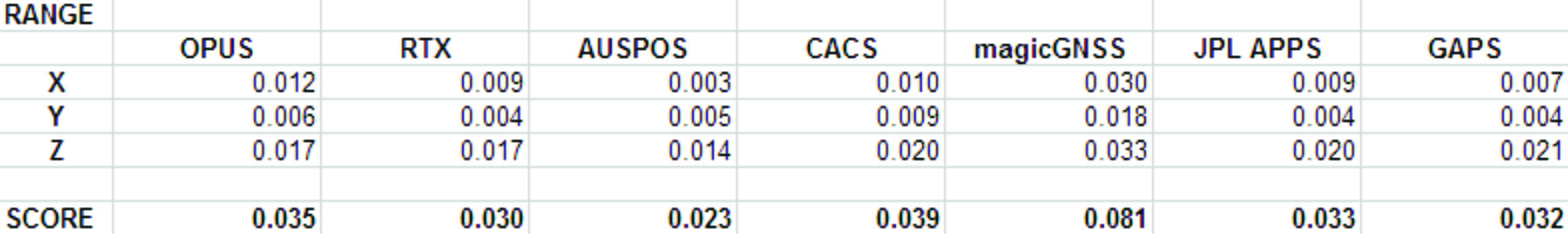
To keep the evaluation simple, the sum of the X, Y and Height range will be the score and the services will be ranked from lowest score to highest score, with the low score being the ‘best.’
Range was chosen as an indicator of the expected maximum error that might be encountered if only a single 24-hour file was observed.
The combined range rewards a processing scheme that best estimates delays, interference, clock errors and other sources of change that occurred during the 32-day trial.
Remember that the every aspect of this ‘competition’ is arbitrary: from the selection of observation sets, to the final scoring system.
The real take-away from this evaluation is not that one service is better, but how close all of the services are to each other.
Two services (JPS’s APPS, magicGNSS) won’t be acceptable to the average user and a third (RTX Centerpoint) may not work for some users based on receiver and antenna support. Details of these problems are presented with the service descriptions below.
The Test Data
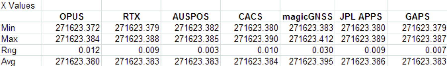
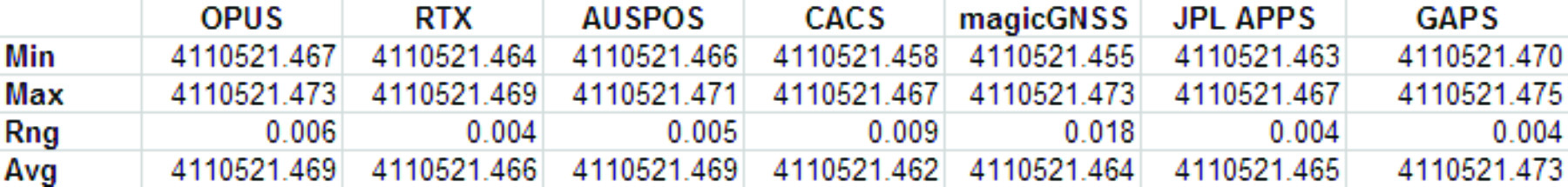
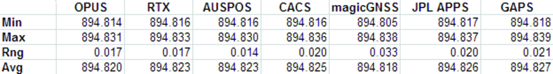
SGU1 in St. George, UT USA was chosen as the observation base. The observations consist of 32 consecutive days (May 3, 2013 through June 3, 2013), 24-hour observation files, 30-second interval, GPS only data. The data files were downloaded from the NGS CORS archive.
Each of the 32 files were submitted to each of the processing services and the results have been tabulated for X, Y and Ellipsoid Height. All data is presented in IGS08 current epoch framed coordinates. All data has been projected to UTM Meters for these comparisons.
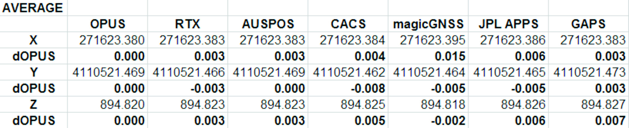
The Average Values
Remember, the real story is how close each of these services produce results to one another. Let’s look at the average positions from each service and the difference from OPUS:
Fig 1: Average Solution Difference from OPUS
As you can see in Figure 1 above, the services were generally within 5mm of OPUS in X, Y and Height.
Position Tracking vs. Time
Fig 2: Service Results X vs. Time
Fig 3: Service Results X Range, Average
Fig 4: Service Results vs. Time
Fig 5: Service Results Y Range, Average
Fig 6: Service Results Z vs. Time
Fig 7: Service Results Z vs. Time
And the Winner Is…
Following are the scores, based on the combination of X, Y and Height range:
Fig 8: The Scores
Score ranking (remember this is just for fun as the services provided remarkably similar results):
AUSPOS
CenterPointRTX
GAPS
APPS
OPUS
CSRS-PPP
magicGNSS
There is a significant issue in the JPL APPS’s reported output positions, which will keep it from being of any use to most users. magicGNSS’s results are significantly different than the other services. User’s should independently evaluate magicGNSS’s suitability for their purpose. SOPAC’s SCOUT could not be evaluated because it patently does not support either the receiver or antenna that was used at the test site.
AUSPOS is a free service from Geoscience Australia. Access is via a simple web interface, the antenna height and type are entered along with a email address for the returned report set. File submission is via FTP or directly from the web interface.
The returned PDF report is the best looking of the reviewed services and includes a Processing Summary showing a map of the CORS sites that were used in the solution. SINEX files are also available.
AUSPOS uses the Bernese GNSS Software for processing baselines, IGS orbits and IGS network stations. Solutions are available for anywhere on the earth.
RINEX files need to be at least 1-hour in length, 6-hour files are recommended. Compact RINEX files are also accepted. Files may be compressed with UNIX, Hatanaka, ZIP, gzip or bzip compression.
Centerpoint RTX Post Processing: Trimble Navigation Limited
CenterPoint RTX Post Processing is a free service offered by Trimble.
It works anywhere in the world and is based on a proprietary Trimble 100+ worldwide CORS network. Accuracy is 2 cm with 1-hour of observation data; 1 cm with 24-hours. Files longer than 24-hours are not accepted.
RTX uses GPS, GLONASS and QZSS tracked SV’s.
The reported output frames include ITRF2008 at current epoch and a user selectable frame like NAD83/2011 2010.0. RTX is one of the few services that will directly export NAD83 framed results.
A single page PDF and a XML result file are returned by RTX. Unfortunately, it is not possible to copy numerical results from the read-only PDF result file to the clipboard.
RTX supports a limited number of receivers (Trimble, Ashtech, Javad, some Leica, some Topcon) and a relatively small subset of IGS modeled antennas. For this test, TEQC was used to stuff the RINEX headers with a comparable Trimble receiver to the actual Ashtech ProFlex 500 receiver that is in use at SGU1. This was all that was required to spoof an accepted device. If the antenna had not been listed, it would have been necessary to spoof the antenna and adjust the height to reflect the difference in L1 phase center offset.
GAPS is an ongoing project at the University of New Brunswick and was developed by the Department of Geodesy and Geomatics Engineering.
File submission is by a web page and GAPS provides a large number of user inputs and potentially allows the highest level of customization of any of the reviewed services:
You may enter a priori coordinates, and a priori constraints
GAPS accepts static or kinematic files
You can set the elevation mask
The Neutral Atmosphere Delay model is selectable
Earth Body Tides and Ocean Tidal Loading can be applied or disabled
GAPS only processes GPS data (no GLONASS.)
Submitted filenames must adhere to the SSSSDDDh.YYt file format. GAPS accepts RINEX and compact RINEX files, they may optionally be gzip, unix compressed or ZIP compressed.
WARNING! APPS only reports the derived position to the nearest decimeter-meter in geographic (lat/lon) coordinates, while reporting ECEF coordinates to a fraction of a millimeter. If you choose to use APPS, you will need to manually convert the ECEF XYZ to geographic coordinates.
JPL’s APPS is based on GIPSY-OASIS (currently version 5). APPS uses NASA’s 70+ Global GPS Network plus densification from other systems (100+ total receivers distributed globally.) Solutions are typically available with 5 seconds delay from observation.
APPS is easy to use, you just specify a file to upload and then click on ‘Upload’ it takes only 15 seconds to get a result after the file upload is complete. You can optionally register for a free account and use email or FTP for bulk uploads.
APPS also has receiver Live Performance Monitoring: (http://www.gdgps.net/monitoring/index.html) which generates a real time graph of three receivers spread through the world.
Before using CSRS-PPP, you will need to register for a free user account.
CSRS has a fantastic desktop application named PPP-Direct that you can just drag and drop files onto. PPP-Direct automatically submits the file and saves all typing, greatly reducing the chance of error.
CSRS-PPP uses both GPS and GLONASS (if available) observables. Ocean Title Loading corrections can be overridden.
CSRS-PPP will accept single frequency files for processing. CSRS will accept RINEX and Compact RINEX, and will decode ZIP, GZIP and unix compression formats.
CSRS-PPP has a fantastic PDF report, a .csv file detailing results epoch by epoch and a great machine readable summary file.
The desktop submission tool, coupled with the great output reports made CSRS-PPP my favorite tool.
magicGNSS accepts emailed files and returns solutions by email. Turnaround time is fast and features a nice PDF report plus SINEX, receiver clock bias files, tropospheric delay, KML trajectory and RINEX CLK clock bias files.
Static and kinematic files with observations from GPS, GLONASS are processed by magicGNSS and the service reportedly Galileo-ready.
magicGNSS uses a subset of IGS stations to provide core coverage.
SCOUT: Scripps Orbit and Permanent Array Center (SOPAC). University of California, San Diego
Scout accepts RINEX and compact RINEX files, compressed (Z, gz, ZIP) submitted from an FTP site or pushed onto a provided FTP server.
Files must be generated on a limited subset of receivers and antennas. While the IGS antenna and receiver files are the basis for acceptable devices, not all IGS-listed devices are on the allowable device list. SCOUT documentation specifically warns against spoofing devices and antennas.
SCOUT uses the GAMIT processing engine.
Because the test data for this article is from a unsupported receiver and the submittal process requires a FTP host server with anonymous access which most users will not bother with, the output from SCOUT was not evaluated.
Conclusion
The similarity of results between all of the services I processed is amazing. That they differ only by millimeters demonstrates the robustness of the algorithms and processes they use.
The difference between AUSPOS, RTX, GAPS, OPUS and CSRS-PPP solutions are negligible. For important positioning projects, it undoubtedly makes sense to use them all.
For locations in the United States, OPUS and RTX return NAD83-2011 framed results. Only OPUS returns derived orthometric heights using GEOID12A. While OPUS has more provenance than the other services, it is easy enough to submit important observations to multiple services as a reality check for important positions.
###
As you read from Mark’s report above, even though OPUS is shut down until the U.S. Congress can resolve its differences, don’t let that stop you from processing your GPS static sessions. However, some level of due diligence on your part is needed as requirements vary for each service. For example, static sessions for the OPUS-RS service can be as short as 15 minutes while other services require two hour GPS static sessions. Furthermore, some services process GPS L1 data while others require both GPS L1 and GPS L2 observations.
Washington, D.C. — The Federal Communications Commission’s Enforcement Bureau today launched a dedicated jammer tip line – 1-855-55-NOJAM (or 1-855-556-6526) – to make it easier for the public to report the use or sale of illegal GPS, cell phone or other signal jammers. It is against the law for consumers to use, import, advertise, sell or ship a GPS or cell jammer or any other type of device that blocks, jams or interferes with authorized communications, whether on private or public property.
The FCC asks people to call the toll-free Jammer Tip Line immediately if:
you are aware of the ongoing use of a cell, GPS, or other signal jammer;
your employer operates a jammer in your workplace;
you observe a jammer in operation at your school or college;
you observe an advertisement for a jammer at a local store; or
you observe a jammer being operated on your local bus, train or other mass transit system.
“We need consumers to be our eyes and ears. Jammers do not just weed out noisy or annoying conversations and disable unwanted GPS tracking, they can prevent 9-1-1 and other emergency phone calls from getting through in a time of need,” Michele Ellison, chief of the Enforcement Bureau, said.
Calls to the Jammer Tip Line will be handled by experienced Enforcement Bureau staff. Callers are encouraged to provide as much detail as possible, including the time and location of the incident, a description of the jamming device (if available), and the name and contact information of the individual or business using or selling the device.
While callers may remain anonymous, the bureau urges callers to provide a contact phone number in case additional information is needed. “Every tip can make a difference,” Ellison said. “While our agents are actively pursuing these violations online and on the street, you can help. We encourage concerned parents, commuters, employees, and anyone else with credible information to tip us off. Working together, we can stop the spread of illegal jammers.
For more information, Frequently Asked Questions about cell, GPS, and Wi-Fi jammers are available at www.fcc.gov/jammers, or email [email protected].
The U.S. Air Force is investing to improve the Global Positioning System (GPS) used worldwide for military and civilian purposes.
Between Sept. 28 and Oct. 1, the Air Force announced four new GPS contracts.
Three were in the $30 million range, including contracts to Rockwell Collins and L-3 Communications to test and engineer new GPS technology, while Raytheon was awarded just under $30 million to develop receiver cards for GPS systems. Honeywell International also received a $14 million contract for engineering services related to GPS.
Maintained by the Air Force, the GPS is used in everything from civilian car navigation to targeting for military weapon systems. The only competition for the American GPS is the Russian GLONASS system, although the European Union is currently developing its own system, nicknamed Galileo.
The contracts were announced days before the Oct. 4 launch that put the first new GPS satellite of 2012 into orbit. That satellite, a Boeing-designed GPS IFF, improves on navigational accuracy, provides a more secure military signal and has a longer design life than older satellite models. It should deploy fully in about three months.