Tag: field work

  • Juniper Systems Updates Aspect Field Mapping Software to v1.2

    Juniper Systems Updates Aspect Field Mapping Software to v1.2

    Photo: Juniper Systems

    Juniper Systems has released a new version of its field mapping software, Juniper Aspect 1.2. The release builds upon and adds to its previous strengths as an easy-to-use, versatile mapping tool.

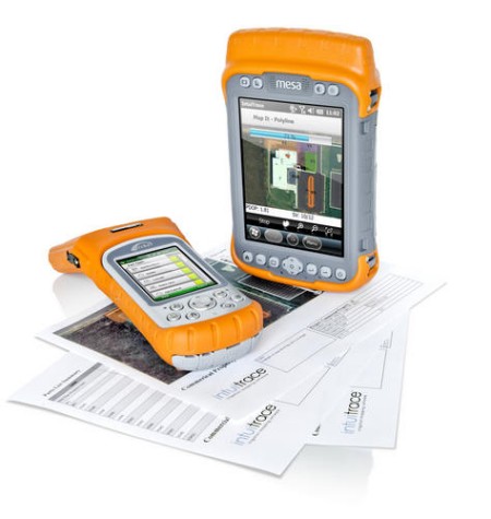
    Juniper Aspect is a field mapping software designed to boost efficiency and productivity, while being simple enough that anyone can quickly learn how to use it, according to Juniper. It places the capabilities of GPS and GIS in the hands of field workers, resulting in more streamlined processes, the company said. Used for any job that requires locating, documenting, and inspecting assets, Juniper Aspect is a flexible solution for many different lines of work.

    Juniper Aspect version 1.2 offers improvements designed to boost worker efficiency and user-friendliness. With a new feature to more extensively filter and organize data, and an ability to more easily import large amounts of data into Excel, Juniper Aspect 1.2 offers greater benefits in time-savings and ease of use, the company said. Furthermore, the software appeals to a  broad audience, as it will now operate on most devices running Windows Mobile 6.0 or higher.

    “At Juniper Systems, our focus is on the customer,” said Jim Benson, Public Works Market Manager at Juniper Systems. “And that’s why we have implemented many of the new changes in Juniper Aspect 1.2—to respond to the requests of our users. This new release is amazingly easy to use, and yet it does more to make jobs easier and workflows run smoother.”

    Current Juniper Aspect customers will automatically receive the new upgrade simply by checking for new updates in their current software version. New customers can contact Juniper Systems to learn more about Juniper Aspect 1.2. They can also download a free preview version of Juniper Aspect.

  • Rugged Tablet for Mobile Professionals

    Rugged Tablet for Mobile Professionals

    T7Q-1(B)
    Photo: GammaTech

    The DuraBook T7Q by GammaTech is a fully rugged Windows 7 Professional tablet PC designed to meet the demands of mobile professionals in the transportation, field services, utilities, and oil and gas industries. Designed with a magnesium-alloy case, the T7Q DuraBook Rugged Tablet is compliant with MIL-STD 810G and IP65, able to withstand vigorous bumps, knocks and sudden shock under rough handling or on-the-move, resisting dust and water.

    It has a seven-inch thin-film-transistor (TFT) LCD display with resistive touchscreen panel and LED backlighting, an m-SATA SSD drive and Intel Atom Processor, and an integrated 5.0-megapixel camera at the back of the unit. Options include a barcode scanner, RFID reader, GPS receiver, and I/O ports such as USB, RS-232, and RJ-45.

  • Smartphone App Locates Injured Farmers in the Field

    Tractor rollovers are the leading cause of death among farmers and claim about 250 lives each year, according to the National Institute of Occupational Safety and Health (NIOSH). These accidents are deadly because they often occur far away from farmers’ homes or roads and they may be unable to reach a phone to call for help. Now, University of Missouri researchers have developed an application for smartphones that uses GPS systems to locate farmers who have rolled their tractors.

    The app, called VRPETERS (Vehicle Rollover Prevention Education Training Emergency Reporting System), uses sensors and GPS capability built into smartphones that can detect rollovers. Once the app detects a rollover, it sends an automatic emergency e-mail and phone message with the coordinates of the accident location to family or emergency responders.

    “The tractor is the main power source for field operations, and tractor rollover accidents have been killing people since the beginning of their use in agricultural production,” said Bulent Koc, assistant professor of agricultural systems management at MU and developer of the app. “More and more farmers are using their smartphones to monitor weather or calculate production inputs while operating machinery. Since they already have their phones with them, installing VRPETERS could help save lives.”

    Data from the NIOSH show that one out of every 10 tractor operators will roll a tractor at least once. NIOSH also notes that only half of the 4.7 million tractors on U.S. farms have rollover protection. In order to minimize false alarm rollovers on the app, Koc and his research assistant Bo Liu designed a device that must be attached to the tractor. This device helps calculate the stability characteristics of the tractor and will provide a warning to the driver when the tractor approaches its rollover point.

    “Many farmers think they can jump out of their tractors in the event of a rollover, but this isn’t the case usually,” Koc said. “Side rollovers can occur in just three-quarters of a second and most people need a second or more to react to an event. So, VRPETERS can benefit farmers when a rollover occurs because they often can’t reach their phones to make an emergency call.”

    VRPETERS can benefit more than just farmers, as the app also can be used on construction vehicles, trucks, snowmobiles, military vehicles, riding lawnmowers and all-terrain vehicles.

    In addition to the rollover device installed on tractors and other dangerous equipment, Koc and Liu designed another device that can be used with VRPETERS. This device can be installed on vehicles and can be used as a backup to stream data to a smartphone or tablet. “With this additional device, parents or fleet managers can obtain real time data on how machines are being used,” Koc said. “If the device detects improper operation, an intervention can occur before an accident happens.”

    Initial testing of VRPETERS was done using a remote-controlled model tractor. Once fully tested on a standard tractor, Koc and Liu will look for an industry partner to market the app.

  • Pacific Crest Offers Wide-Band Data Link for Field Communications

    Photo: Pacific Crest
    Photo: Pacific Crest

    Pacific Crest has introduced the XDL Rover, an advanced, high-speed, wireless data link built to withstand the rigors of GNSS/RTK surveying and precise positioning.

    The XDL Rover is a lightweight, ruggedized UHF receiver designed for digital radio communications between 403 and 473 MHz in either 12.5 or 25 kHz channels. It uses Pacific Crest’s latest generation XDL modem technology while remaining backward compatible with existing Pacific Crest products. Users can instantly communicate with GNSS precise positioning receivers that share the same protocols throughout the world.

    “The XDL Rover is an ideal high-speed radio receiver for products that require a one-way communications link,” said Dale Hermann, director of marketing and sales for Pacific Crest. “Its interoperability with existing equipment and greater functionality will allow customers to rapidly integrate and cost-effectively deploy the XDL Rover with their products and solutions.”

    The XDL Rover joins the rapidly growing line of XDL products that includes the XDL Micro, a transceiver OEM board. The XDL Micro is a 0.5 Watt UHF transceiver designed for integration into products that require either a one- or two-way radio communication link that is configurable for operation between 403 and 473 MHz. The XDL radio line is based upon the successful ADL products from Pacific Crest.

  • Trimble Adds Two Handhelds to GIS Data Collection Portfolio

    Trimble introduced today the Trimble Geo 5 and Juno 5 handheld GNSS devices, further extending Trimble’s portfolio for data collection, maintenance and inspection applications. The Geo 5 and Juno 5 series are both optimized for GIS field workflows, including Trimble’s TerraSync field software available on all Trimble GIS platforms.

    Since 1994, the Trimble GeoExplorer line of GNSS handhelds has been used for professional GIS data-collection applications. While the GeoExplorer 6000 series is the most capable Trimble handheld for GIS data collection, not all customers require the larger screen and innovative Floodlight technology of the 6000 series. The Geo 5 provides the essential functions for all day, submeter productivity in a smaller package, Trimble said.

    The Trimble Juno product line is used worldwide for maintenance, inspections and asset management applications. With the addition of the Juno 5 series, Trimble is providing a rugged handheld that delivers the capabilities and convenience of a smartphone, Trimble said. The Juno 5’s slim, ergonomic design is thinner and lighter than other rugged computing products in its class today and provides a more advanced feature set than the Juno 3 series.

    “Whether users are engaged in initial data-collection tasks or inspection of assets, it is critical they have a complete solution they trust,” said Daniel Wallace, general manager of Trimble’s GIS Data Collection Division. “Now with two platforms in both the Geo and Juno families, customers can confidently choose a handheld that best fits their needs. Trimble TerraSync software is the unifying workflow that brings these choices together, so customers can always trust the quality of their data throughout the complete lifecycle of a field management project.”

    Complete with wireless communications options, integrated cameras and bright, sunlight-readable screens, both devices are built for work in the field and rugged enough to withstand shock, vibration, water and dust.

  • Magellan eXplorist GIS Pro 10 GPS Now Offers Effigis OnPOZ Data Collection and Post-Processing Software

    Magellan and Effigis announced a partnership and reseller agreement to create a comprehensive out-of-the-box solution for Magellan customers to collect and post-process geo-localized data using Effigis OnPOZ software on the Magellan eXplorist GIS Pro 10.


    According to the announcement, as part of the partnership, three Effigis OnPOZ precision positioning software products are available for the Magellan eXplorist GIS Pro 10, a rugged, lightweight and waterproof handheld GPS device specifically designed for professional GPS/GIS data collection.   

    • EZTag CE, geospatial data acquisition software, facilitates the collection of geospatial data including points, lines and polygons plus their specific attributes, and valuable GNSS observations necessary for post-processing.  Users can customize the data capture properties to match their office database structure. 
    • GNSS Driver for ArcPad, software extension that improves the quality of data collected using ESRI ArcPad GIS software.
    • EZSurv, GNSS post-processing software, provides a reliable, efficient RTK offline solution for data integrity. Users can play back their RTK survey for QA control, make corrections to non-RTK GNSS field data, or significantly improve GIS data accuracy.  

    “The combination of Effigis OnPOZ software and the Magellan eXplorist GIS Pro 10 device creates a powerful and accurate, yet cost-effective solution for collecting and post-processing GIS data,” said Stig Pedersen, Associate Vice President of Product Management for Magellan. “Our partnership with Effigis enables Magellan to continue providing GIS professionals with complete GIS data collection solutions to facilitate their biggest GIS mobile application challenges.”   

    Magellan reports that with its rugged IPX-7 waterproof casing, the eXplorist GIS Pro 10 device is designed for GIS professionals who need to collect GPS/GIS data. The GPS device can deliver 3 to 5 meters accuracy in real-time using its internal GPS receiver and works with supported Bluetooth-enabled GPS receivers to achieve 1 to 3 meter accuracy. Powered by Windows Mobile v6.5 OS, the Pro 10 GPS device allows GIS professionals to run powerful GIS data collection software, such as Effigis, and a wide range of Windows Mobile data collection applications.

    “Partnering with a leading GPS manufacturer like Magellan will allow Effigis to reach a wider range of GNSS users,” said Denis Parrot, President of Effigis. “With this agreement, we are very pleased to continue to bring an enhanced level of data accuracy and reliability to users.”

    Effigis OnPOZ software for the Magellan eXplorist GIS Pro 10 is available now from Magellan’s authorized GIS resellers as a bundled option with the GPS device, or as a software-only add-on for users who previously purchased the Pro 10 model. More details are available at www.MagellanGPS.com/GIS.

  • F4Devices Announces Flint Rugged Handheld

    FlintF4Devices, a subsidiary of F4 Tech and strategic partner with BAP Precisions, Taiwan, has introduced a new generation of high-precision GNSS devices for GIS field applications, the Flint rugged handheld. With the new Flint handheld, field workers requiring a rugged mobile handheld device have a unit that is lightweight, compact, rugged, and cost-effective, the company said. The Flint fits well into GIS field data collection markets such as municipalities, oil and gas and forestry, F4Devices said.

    The Flint handheld offers a unique, one-of-a-kind combination of flexible GPS configurations, ranging from 1 to 3 meters to sub-meter accuracies, while supporting geotagging with the 5 megapixel autofocus camera as well as Wi-Fi, Bluetooth, and 3G data. There are two versions to choose from, the S812H (includes GPS, Bluetooth, Wi-Fi and 5 MP camera) and the S852H (includes GPS, Bluetooth, Wi-Fi, 5 MP camera and 3G data).

    “The new Flint handheld impresses, from the first moment you see it. The ruggedness of the device, IP65, in this small of a package while achieving the GPS accuracies we have been able to achieve is something to acknowledge as a leader in its class,” said Brian Holley, director of Distribution for F4Devices. “Add in its high-resolution, sunlight-readable VGA screen, extendable data storage and Microsoft Office Mobile standard on all units, this makes it even more impressive.”

    The Flint handheld is specifically designed for field professionals looking for a rugged, dependable feature-rich device, said F4Devices. The camera button is located as if the user was holding a camera. Combined with the GPS, it provides a powerful solution for precise geotagging.  In tough environments, whether it is extreme weather or high multi-path, the Flint handheld is up to the challenge, the company said.

    The F4Devices Flint is shock-proof, dust-proof, and waterproof. The battery supports the field users’ needs with at least 10 hours of performance.

    F4Devices, along with BAP Precisions, is focused on supporting solutions providers by working with them directly to integrate their applications with the Flint handheld. Any feature or application in the Flint handheld is accessible to software engineers for full and complete integration, allowing a fully developed solution to be offered to their clients, the company said. API’s are available for solutions providers to access and communicate with the features they require.

    The 3G data modem in the Flint handheld allows field users to stay in touch remotely, increasing productivity. This also allows real-time communications with the office for critical information upload. This also provides a level of safety for field users by easily staying in touch with supervisors or persons in charge.

    The Flint handheld is available now.