Tag: fieldwork

  • Trimble launches TSC7 controller and apps for surveyors

    Trimble has released the Trimble TSC7 controller, a new field solution for land and civil construction surveyors. The TSC7 brings powerful enhancements to the field and was designed based on customer feedback, the company said. It provides a tablet experience with a physical keyboard and a sunlight readable 7-inch touchscreen that supports pinch, tap and slide gestures.

    Users can interact with the TSC7 intuitively, easily zooming, panning and selecting items on the large touchscreen. Front- and rear-facing cameras allow users to video conference their office from the field for on-the-job support, and capture high-definition videos and images that provide valuable context to their data and clients.

    Trimble TSC7 controller.

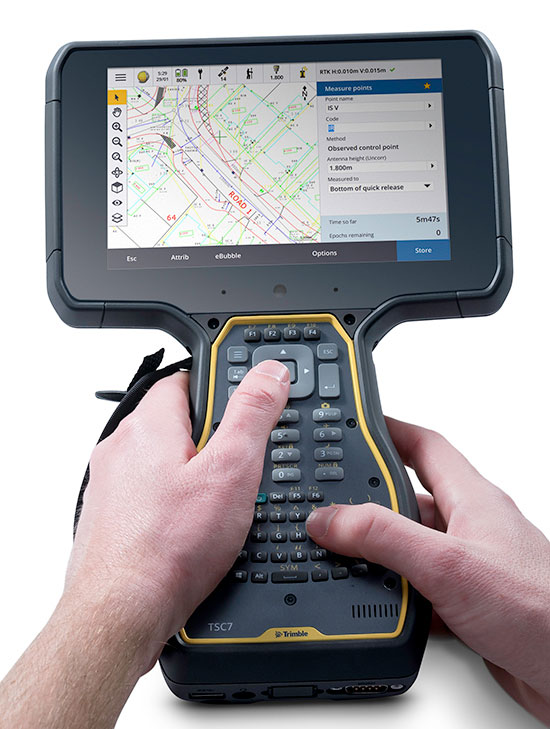
    The TSC7 also leverages the power of Windows 10 Professional, driven by an Intel Pentium 64-bit quad-core processor. The processor and operating system make it easy to process data in spreadsheets and run office software programs. An ergonomic form factor, IP68-certified rugged design and optional, user-interchangeable modules make the TSC7 a flexible solution for all surveying applications.

    Trimble also announced a new version of its field software, Trimble Access 2018. The software features a new user interface and powerful graphics capabilities to deliver enhanced workflows for field surveyors.

    Access 2018 has been redesigned with even more intuitive menus and screen navigation to take advantage of the TSC7’s 7-inch touchscreen and computing power, while leveraging software workflows, which include applications for general survey, roading, tunnels and pipelines.

    Access 2018 also integrates with the Trimble Sync Manager application to enable cloud-based data management between the office and the field. Surveyors can quickly start working by downloading preconfigured jobs in the field with DXF maps and CSV files linked ready to start surveying. Sync Manager also integrates seamlessly with Trimble Business Center software and is compatible with other industry office software platforms.

    https://youtu.be/I2oMLIvu3Ck

    “Today’s surveyors are managers of geospatial intelligence,” said Ron Bisio, vice president of Trimble Geospatial. “Data has more depth and complexity than ever before, and surveyors’ reputations depend on transforming that data into valuable, reliable information for their clients. The TSC7 and Access 2018 form the new backbone of our field solutions ecosystem, and give our users a leading edge to be data experts.”

    Rover Systems

    Trimble is also releasing two new rover systems for civil engineering and construction applications — the Trimble Siteworks Positioning System for Construction Surveyors and the Trimble Siteworks Positioning System for Supervisors.

    Both systems feature new Siteworks Software, next-generation survey software tailored for construction workflows. Completely redesigned from the ground up, Siteworks Software features a new interface that is optimized for ease-of-use and productivity. Configurable views, colorful graphics and natural interactions and gestures make Siteworks software intuitive and easy to learn.

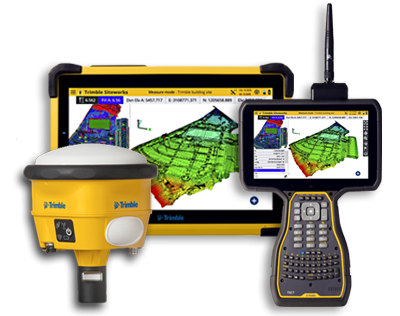
    Siteworks Positioning System for Construction Surveyors is comprised of the Trimble SPS986 GNSS smart antenna, the TSC7 controller and Siteworks software. It enables construction surveyors to work with complex 3D models, collect large data sets faster, visualize complex 3D models more easily and work day or night efficiently.

    Siteworks Positioning System for Supervisors is comprised of the SPS986 GNSS smart antenna, the Trimble T10 Tablet and Siteworks software. It enables construction supervisors to run full office software packages, including Business Center – HCE and Microsoft Office, and to work easily with data and 3D models in the field without carrying a laptop.

    The Trimble TSC7 Controller running the current version of Trimble Access field software will be available worldwide in May through Trimble’s Geospatial distribution partners.

    The Access 2018 beta program will open to applicants in early May.

  • Tersus David GNSS receiver available in 7 kits

    Tersus David GNSS receiver available in 7 kits

    Tersus GNSS is now offering its David real-time kinematic (RTK) GNSS receiver with seven new base/rover kits.

    Tersus GNSS is a provider of centimeter-accuracy GNSS RTK solutions. The Tersus David GNSS receiver with its components create an affordable solution delivering high-precision signal reception, integrated in a small, and lightweight package.

    The David GNSS receiver supports GPS L1/L2, GLONASS G1/G2 and BeiDou B1/B2. With David, surveyors users can take full advantages of common platforms such as smartphones, tablets or traditional handheld modules to collect data.

    Coupled with an external antenna, the Survey App and post-processing software, the David GNSS receiver is a low-cost solution for all survey applications, including real-time RTK positioning and data collection for PPK.

    Four (4) GB on board an embedded multimedia card (eMMC) makes it easy to save data for post processing. The compact, IP67-rated enclosure and versatile accessories alleviate most inconveniences encountered in field work.

    “The launch of David GNSS Receiver marks a major step forward for Tersus as well as for surveying professionals,” said Xiaohua Wen, founder and CEO of Tersus. “The David is a cost-efficient and palm-sized GNSS receiver. Tersus is constantly working to make each surveying task easier and more productive by providing high-quality GNSS RTK surveying equipment. Our focus is on enabling surveying professionals make data collection more convenient, post (data collection) processing more accurate, and better equipping them to do surveying in the field.”

    Kits offered include:

  • TerraGo launches GXP InForm application for BAE Systems’ GXP Xplorer

    TerraGo launches GXP InForm application for BAE Systems’ GXP Xplorer

    TerraGo is now offering GXP InForm, a new add-on module for BAE SystemsGXP Xplorer platform.

    The application, built using the TerraGo Magic platform and available today from BAE Systems, offers iOS, Android and web apps that make it easy to securely capture and share field reports from any location.

    With GXP InForm, users can customize forms, maps and workflows so field applications can be quickly configured and instantly deployed to support any operation, in any location.

    GXP InForm’s mobile features, including basemaps and forms, are available without network connectivity so personnel can get the job done in the most remote locations and demanding conditions. When a network connection is available, GXP InForm enhances situational awareness for all stakeholders with the bi-directional flow of information between headquarters and on-site personnel.

    “We constantly look for ways to help our customers extend the value of GXP Xplorer across the enterprise and improve the quality of geospatial intelligence for all stakeholders,” said Damon Brady, director, product development and programs at BAE Systems. “With GXP InForm, mobile users get access to actionable imagery, while command units gain access to site reports, photos and videos that enhance the fidelity of their common operating picture.”

    “We’re proud of this collaboration to build GXP InForm,” said Dave Basil, president and CEO at TerraGo. “It’s the result of a long-running and successful partnership with BAE Systems that goes back to 2008. The combination of GXP Xplorer, as an open data-management platform, and GXP InForm, as a customizable reporting application, provides great value to our customers that need to leverage vast geospatial data sources and tailor field workflows to all types of operations and missions.”

    TerraGo is offering a webinar at 1 p.m. ET on Feb. 21, with a discussion and demonstration of GXP InForm. Register here.

  • Mobile device monitors fieldworkers in dangerous conditions

    Mobile device monitors fieldworkers in dangerous conditions

    Winter weather can make fieldwork more dangerous. If a worker falls off a structure, becomes trapped or is otherwise incapacitated, in a remote location or working alone, he or she could be without aid for hours.

    The Mobile Defender Model-S (MD-S) by SecuraTrac is designed to monitor field workers and provide alerts to keep them safe. It provides global GPS services and is able to withstand extreme conditions and uses.

    In an emergency situation, taking out a cell phone or tablet to make a call or send a message is not always possible.

    The MD-S monitors worker status and can immediately call for help if a problem is detected. The worker can also press a button to be connected to responders.

    The MD-S features SecuraTrac’s new fall advisory capability and more than 30 days of battery life on a single charge, the company said.

  • SuperSurv mobile app increases RTCM 3.1 support

    Makers of the mobile GIS app SuperSurv, developed by Supergeo Technologies Inc., are working to increase its GNSS positioning functionality.

    In recent weeks, the SuperSurv product team began to enhance SuperSurv’s NTRIP solution, aiming to adopt more RTCM versions and provide a better GNSS positioning service. NTRIP (Networked Transport of RTCM via internet protocol) is a protocol to send GNSS-related data through the internet, which enables users of differential GPS or network RTK to get correction parameters after connecting to the internet. The correction parameters can be used to calculate a more accurate GNSS location.

    Supergeo’s product team is developing the support for RTCM 3.1, including Type 1021 and 1023, two kinds of messages. Type 1021 contains the seven parameters for 3-axis coordinate transformation — three for 3-axis translation, another three for 3-axis rotation and a scale factor.

    Through the original projection method, users can only get rough coordinates. However, with NTRIP solution, users can send the current location to the server and then receive the parameters provided by it. This makes it easier to obtain a suitable local coordinates frame for more precise coordinates.

    The Type 1023 message provides more accurate grid residuals. By establishing a 4 x 4 mask window around the rover, users will receive the 3-axis corrections within these 16 grids. Accordingly, a more accurate GNSS positioning is achievable after interpolation.

    Image: SuperSurv
    Image: SuperSurv

    After completing the development, this technique will be implemented in the current version, SuperSurv 10.1. Combined with SuperSurv’s existing GIS features, Supergeo believes the newly supported RTCM 3.1 will bring a brand-new experience to fieldworkers.

    Launched in November 2017, current version 10.1 offers three major new features, including snapping, coordinate system customization and Layerset. Google Maps and TIFF are also supported.

    Supergeo’s product manager for mobile GIS, Zara Yu, recommend that users activate the point-data auto-collection with RTCM 3.1. This method not only helps users skip repeated operations but also enhances the data quality and efficiency.

    SuperSurv can be downloaded and tried at no cost. Online tutorials are also available.