As a part of the NASA Commercial Lunar Payload Services initiative, Firefly Aerospace will land the Blue Ghost lander on the lunar surface in 2024. Onboard, the Lunar GNSS Receiver Experiment (LuGRE) payload will determine whether signals from two GNSS constellations can reach the lander and provide precise navigation on the moon for future missions.
During a 12-day mission in the moon’s Mare Crisium basin, LuGRE will obtain the first GNSS fix on the lunar surface and receive signals from both GPS and Galileo. The LuGRE payload is managed by NASA’s Space Communications and Navigation program office.
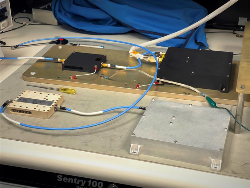
This payload is a collaborative effort between NASA and the Italian Space Agency to expand the capabilities of Earth-based navigation systems. Navigation engineers at NASA’s Goddard Space Flight Center in Greenbelt, Maryland, have been testing the payload’s GNSS receiver and low noise amplifier. The receiver was developed and built by the Italian company Qascom.
These components will be critical to LuGRE obtaining signals from the GPS and Galileo satellites. To prepare for operating on the moon, NASA engineers used a GNSS simulator to test and configure the payload to accurately receive and process the signals.
The LuGRE payload GNSS receiver and low noise amplifier. (Image: NASA/Dave Ryan)
The Goddard team delivered in February the flight hardware to Firefly Aerospace in Cedar Park, Texas, where it will be integrated into the Blue Ghost lander.
Astronauts and rovers traversing the lunar surface will need precise location and tracking data for their exploration endeavors. The data gathered from the LuGRE payload will be used to further develop GNSS-based navigation systems for future missions to the moon.
Collaboration powers GPS and Galileo navigation experiment
By Danny Baird NASA’s Goddard Space Flight Center
As the Artemis missions journey to the Moon and NASA plans for the long voyage to Mars, new navigation capabilities will be key to science, discovery and human exploration.
Through NASA’s Commercial Lunar Payload Services initiative, Firefly Aerospace of Cedar Park, Texas, will deliver an experimental payload to the Moon’s Mare Crisium basin. NASA’s Lunar GNSS Receiver Experiment (LuGRE) payload will test a powerful new lunar navigation capability using Earth’s GNSS signals at the Moon for the first time.
“In this case, we are pushing the envelope of what GNSS was intended to do — that is, expanding the reach of systems built to provide services to terrestrial, aviation, and maritime users to also include the fast growing space sector,” said J.J. Miller, deputy director of Policy and Strategic Communications for NASA’s Space Communications and Navigation (SCaN) program. “This will vastly improve the precision and resilience of what was available during the Apollo missions, and allow for more flexible equipage and operational scenarios.”
LuGRE — developed in partnership with the Italian Space Agency (ASI) – will receive signals from both GPS and Galileo, and use them to calculate the first-ever GNSS location fixes in transit to the Moon and on the lunar surface.
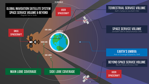
“Space missions close to Earth have long relied on GNSS for their navigation and timekeeping,” said Joel Parker, LuGRE principal investigator at NASA’s Goddard Space Flight Center in Greenbelt, Maryland. “In recent years, NASA and the international community have pushed the boundaries of what was considered possible by using these techniques in the Space Service Volume and beyond.”
This graphic details the different areas of GNSS coverage. (Image: NASA/Danny Baird)
Missions in the GNSS Space Service Volume — from about 1,800 miles to 22,000 miles in altitude — receive signals that spill past Earth’s edge from GNSS satellites on the opposite side of the planet. The first Space Service Volume experiments occurred around the dawn of the new millennium. Since then, numerous missions in the Space Service Volume have reliably used GNSS to navigate.
In 2016, the NASA’s Magnetospheric Multiscale Mission (MMS) employed GPS operationally at a record-breaking 43,500 miles from Earth. Then, in 2019, MMS broke its own record by fixing its location with GPS at 116,300 miles from Earth — nearly halfway to the Moon.
At these extreme altitudes, missions need extremely sensitive GNSS receivers. The LuGRE mission will use a specialized weak-signal receiver developed by Qascom, an Italian company specializing in space cybersecurity and satellite navigation security solutions, and funded by ASI.
LuGRE teams are now testing the payload in preparation to deliver it for integration onto the Firefly “Blue Ghost” lander in November of this year. Launch is slated for no earlier than 2024 from Cape Canaveral, Florida, aboard a SpaceX Falcon 9 rocket.
During the multi-week flight to the Moon, LuGRE will collect GNSS signals and perform navigation experiments at different altitudes and in lunar orbit. After landing, LuGRE will deploy its antenna and begin 12 days of data collection, with the potential for extended mission operations. NASA and ASI will process and analyze data downlinked to Earth, and then share results publicly.
“LuGRE is the latest effort in a long line of missions designed to expand high-altitude GNSS capabilities,” said Fabio Dovis, LuGRE co-principal investigator, ASI. “We’ve developed a cutting-edge experiment that will serve as the foundation for operational GNSS systems at the Moon.”
The LuGRE mission seeks to spark further development of GNSS-based navigation capabilities near and on the Moon, even as NASA plans to begin using high-altitude GNSS operationally for future lunar missions. NASA and ASI will bring the results of this work forward to the space community through the International Committee on GNSS, a United Nations forum focused on ensuring the interoperability of GNSS signals. These capabilities are also a key stepping stone towards building LunaNet, an architecture that will unify cooperative networks into seamless lunar communications and navigation services.
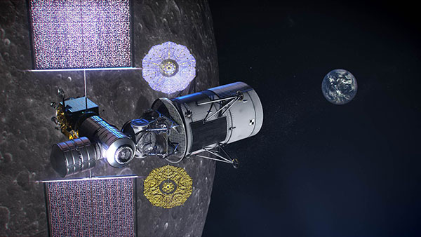
Artistic rendering of LuGRE and the GNSS constellations. In reality, the Earth-based GNSS constellations take up less than 10 degrees in the sky, as seen from the Moon. (Image: NASA/Dave Ryan)
“The lunar deliveries we’re sourcing from commercial vendors are providing a number of innovative new technologies and opportunities to conduct experiments with affordable access to the lunar surface,” said Jay Jenkins, Commercial Lunar Payload Services Program executive. “LuGRE is one example of the progress that government and industry can make when united in their exploration objectives.”
Developing new uses of GNSS for emerging space operations is a priority for the SCaN program at NASA headquarters, as the lead organization responsible for implementing guidance from Space Policy Directive-7, which directs NASA to develop requirements for GPS support of space operations and science in higher orbits and beyond into cislunar space.
Space communications and navigation engineers at NASA are evaluating the navigation needs for the Artemis program, including identifying the precision navigation capabilities needed to establish the first sustained presence on the lunar surface.
“Artemis engages us to apply creative navigation solutions, choosing the right combination of capabilities for each mission,” said Cheryl Gramling, associate chief for technology in the Mission Engineering and Systems Analysis Division at Goddard Space Flight Center in Greenbelt, Maryland. “NASA has a multitude of navigation tools at its disposal, and Goddard has a half-century of experience navigating space exploration missions in lunar orbit.”
Alongside proven navigation capabilities, NASA will use innovative navigation technologies during the upcoming Artemis missions.
“Lunar missions provide the opportunity to test and refine novel space navigation techniques,” said Ben Ashman, a navigation engineer at Goddard. “The Moon is a fascinating place to explore and can serve as a proving ground that expands our navigation toolkit for more distant destinations like Mars.”
Illustration of NASA’s lunar-orbiting Gateway and a human landing system in orbit around the Moon. (Image: NASA)
Ultimately, exploration missions need a robust combination of capabilities to provide the availability, resiliency, and integrity required from an in-situ navigation system. Some of the navigation techniques being analyzed for Artemis include the following.
Radiometrics, optimetrics and laser altimetry
Radiometrics, optimetrics, and laser altimetry measure distances and velocity using the properties of electromagnetic transmissions. Engineers measure the time it takes for a transmission to reach a spacecraft and divide by the transmission’s rate of travel — the speed of light.
These accurate measurements have been the foundation of space navigation since the launch of the first satellite, giving an accurate and reliable measurement of the distance between the transmitter and spacecraft’s receiver. Simultaneously, the rate of change in the spacecraft’s velocity between the transmitter and spacecraft can be observed due to the Doppler effect.
Radiometrics and optimetrics measure the distances and velocity between a spacecraft and ground antennas or other spacecraft using their radio links and infrared optical communications links, respectively. In laser altimetry and space laser ranging, a spacecraft or ground telescope reflects lasers off the surface of a celestial body or a specially designated reflector to judge distances.
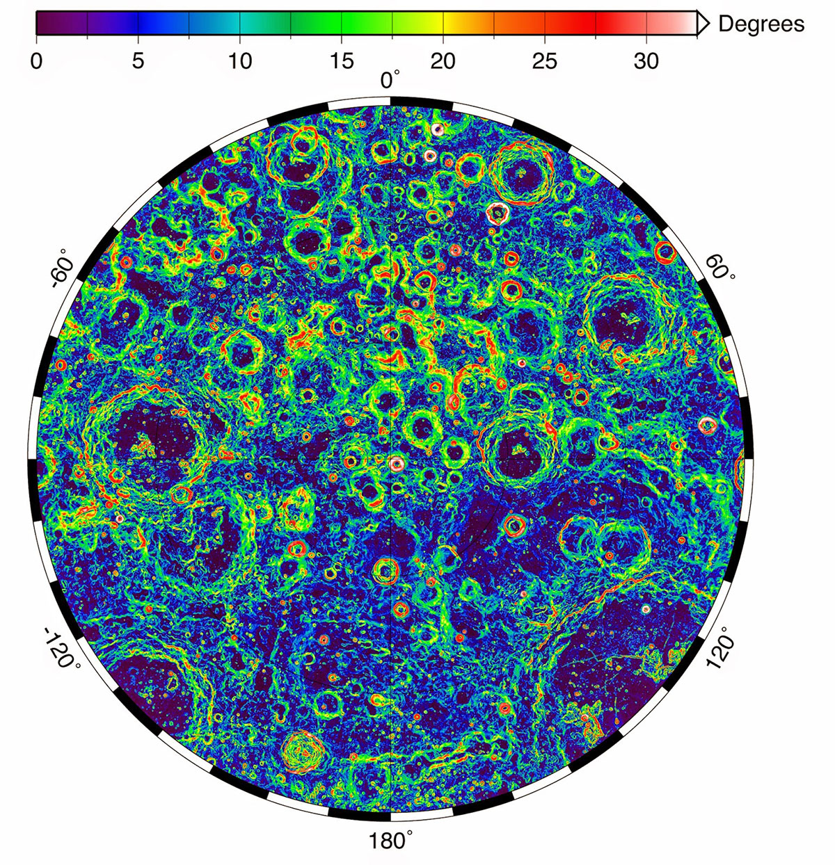
The Lunar Orbiter Laser Altimeter (LOLA) aboard the Lunar Reconnaissance Orbiter (LRO) sends laser pulses down to the surface of the Moon from the orbiting spacecraft. These pulses bounce off of the Moon and return to LRO, providing scientists with measurements of the distance from the spacecraft to the lunar surface. As LRO orbits the Moon, LOLA measures the shape of the lunar surface, which includes information about the Moon’s surface elevations and slopes. This image shows the slopes found near the South Pole of the Moon. (Image: NASA/LRO)
Optical navigation
Optical navigation techniques rely on images from cameras on a spacecraft. There are three main branches of optical navigation.
Star-based optical navigation uses bright celestial objects such as stars, moons, and planets for navigation. Instruments use these objects to determine a spacecrafts’ orientation and can define their distance from the objects using the angles between them.
As a spacecraft approaches a celestial body, the object begins to fill the field of view of the camera. Navigation engineers then derive a spacecraft’s distance from the body using its limb — the apparent edge of the body — and centroid, or geometric center.
At a spacecraft’s closest approach, Terrain Relative Navigation uses camera images and computer processing to identify known surface features and calculate a spacecraft’s course based on the location of those features in reference models or images.
NASA will use data gathered from LuGRE to refine operational lunar GNSS systems for future missions.
Weak-signal GPS and GNSS
NASA is developing capabilities that will allow missions at the Moon to leverage signals from GNSS constellations. These signals — already used on many Earth-orbiting spacecraft — will improve timing, enhance positioning accuracy, and assist autonomous navigation systems in cislunar and lunar space.
In 2023, the Lunar GNSS Receiver Experiment (LuGRE), developed in partnership with the Italian Space Agency, will demonstrate and refine this capability on the Moon’s Mare Crisium basin. LuGRE will fly on a Commercial Lunar Payload Services mission delivered by Firefly Aerospace of Cedar Park, Texas. NASA will use data gathered from LuGRE to refine operational lunar GNSS systems for future missions.
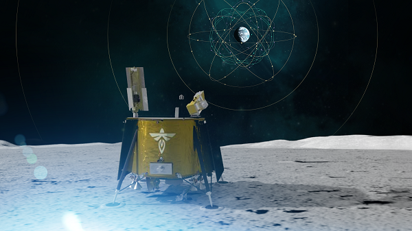
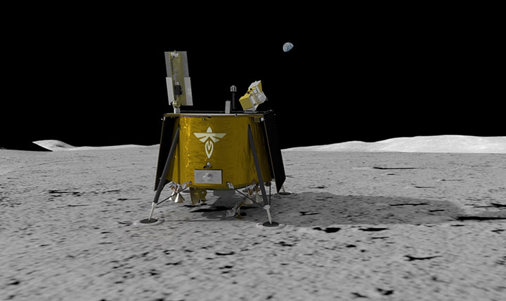
Illustration of Firefly Aerospace’s Blue Ghost lander on the lunar surface. The lander will carry a suite of 10 science investigations and technology demonstrations to the Moon in 2023 as part of NASA’s Commercial Lunar Payload Services (CLPS) initiative.
Autonomous navigation
Autonomous navigation software leverages measurements like radiometrics, celestial navigation, altimetry, terrain-relative navigation, and GNSS to perform navigation onboard without contact with operators or assets on Earth, enabling spacecraft to maneuver independently of terrestrial mission controllers. This level of autonomy enables responsiveness to the dynamic space environment.
Autonomous navigation can be particularly useful for deep space exploration, where the communications delay can hamper in-situ navigation. For example, missions at Mars must wait eight to 48 minutes for round trip communications with Earth depending on orbital dynamics. During critical maneuvers, spacecraft need the immediate decision-making that autonomous software can provide.
LunaNet navigation services
LunaNet is a unique communications and navigation architecture developed by NASA’s Space Communications and Navigation (SCaN) program. LunaNet’s common standards, protocols, and interface requirements will extend internetworking to the Moon, offering unprecedented flexibility and access to data.
For navigation, the LunaNet approach offers operational independence and increased precision by combining many of the methods above into a seamless architecture. LunaNet will provide missions with access to key measurements for precision navigation in lunar space.
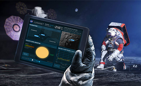
Artist’s conceptualization of Artemis astronauts using LunaNet services on the Moon, a unique approach to lunar communications and navigation. The LunaNet communications and navigation architecture will enable the precision navigation required for crewed missions to the Moon and place our astronauts closer to scientifically significant lunar sites, enhancing the our missions’ scientific output. (Image: NASA/Resse Patillo)