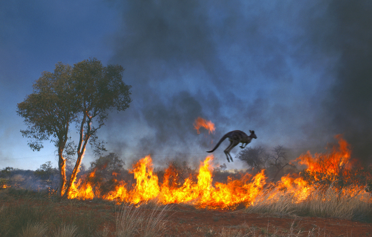
Australia-based Aptella is offering free access to its AllDayRTK high-accuracy positioning service for volunteers and organizations involved in bushfire and flood recovery efforts.
Reliable positioning aids in coordinating recovery operations, assessing damage and restoring essential infrastructure. However, extreme weather events often disrupt permanent GNSS base stations due to power outages and loss of internet connectivity.
To address this challenge, AllDayRTK has developed a Synthetic Base Station system, enabling high-accuracy positioning even when permanent bases are offline. This technology creates a virtual reference station network that ensures continuity of service in disaster-affected regions, supporting emergency response teams and volunteers where traditional infrastructure cannot.
Key Benefits:
Free access for registered volunteers and recovery organizations.
High-accuracy GNSS positioning for mapping, surveying and logistics.
Synthetic Base Station technology ensures service continuity without reliance on damaged or offline permanent bases.
“Aptella is always willing to do what we can to support volunteer services with high-accuracy positioning that assist with recovery after natural disasters and extreme weather events,” said Greg Macklin, CEO at Aptella. “Our commitment is to ensure that those on the front lines have the tools they need to rebuild communities quickly and safely.”
Hurricane Matthew, which formed Sept. 28 and dissipated Oct. 10, brought torrential rains to the Carolinas, causing widespread flooding. The above is a screenshot from a drone inspection video.
In the wake of Hurricane Matthew, Verizon used drones for cell-site inspections in North Carolina and South Carolina. The aerial survey shortened cell-site recovery to hours compared to potentially days, based on the severity of flooding.
The quadcopter used was operated by Measure UAS, which conducted the flights with Federal Aviation Administration (FAA) authorization.
Flights used a two-person crew that included a ground pilot for the UAS, and a visual observer of the operation for safe, legal and insured operations, Verizon said.
While Verizon was able to access most hurricane-affected sites quickly to assess damage, some sites were not accessible because of extreme flooding. That’s where the UAS came in.
Streaming in HD
The UAS was able to livestream and record high-definition video and high-resolution photographs of a cell site.
The first flight to a site surrounded by water near Elm City, North Carolina, and the Tar River Reservoir showed engineers that the base-station equipment — which was elevated on stilts — was not underwater and had not suffered visible damage.
After determining the site was safe to access, Verizon’s Network team secured an air boat and refueled the generator, bringing the site back into service within hours.
Verizon completed successful cell site inspection trials earlier this year in New Jersey providing valuable 3D imagery and system performance data via UAS.Now the company has several vendors to aid Verizon’s network maintenance and operations.
airborne service
In October, Verizon conducted the first trial with Verizon’s Airborne LTE Operations during an emergency management and disaster recovery exercise in Cape May, New Jersey.
The exercise simulated how Verizon’s network could provide 4G LTE coverage from a 17-foot wingspan UAS operated by American Aerospace Technologies (AATI) to first responders in an area impacted by a severe weather event where no wireless service is available.
While this is the first simulation in an emergency scenario, AATI and Verizon are conducting trials nationally testing connectivity between manned and unmanned aircraft and Verizon’s 4G LTE network, including in-flight connectivity.
The Louisiana Department of Transportation and Development (DOTD) has deployed TerraGo Edge for the inspection of flood protection infrastructure including levees, dams and reservoirs.
The DOTD’s Public Works and Water Resources Division inspects more than 1,100 miles of levees, four times every year.
The legacy inspection system was a custom-built application developed by an engineering services firm, which used Trimble Yuma ruggedized tablets. Over time, the system became less reliable and database updates were cumbersome and problematic. To truly fix the system would have meant more custom development services and other expenses.
Each of the six Yuma tablets, fully configured, ran around $6,000. The annual software maintenance was also expensive at around $18,000, which did nothing to improve the reliability of the system.
“We really wanted a cloud-based system, so we wouldn’t need to maintain a database server on-site. And if we could deploy an Android solution, those tablets would only cost us about $200, so the hardware would be pennies on the dollar. We could break and replace a lot of Android tablets compared to a traditional, ruggedized GPS tablet at $6,000,” said Doug Taylor, Director of Levees, Dams and Reservoirs at the DOTD.
After a series of successful field trials, DOTD knew it had found a mobile solution that met their requirements across the board for reliability, ease of use and customizability, all with a cloud-based database solution at a fraction of the cost.
TerraGo Edge’s customizable forms mean the DOTD never has to pay a software services fee for modifying a hard-coded solution again. They can design their own forms, maps and workflows, flexibly changing them whenever needed to improve the speed and quality of inspections and maintenance.
“Honestly, my favorite part about TerraGo Edge is that it’s just easy to use,” said Taylor. “It’s easy to use in the field and it’s easy to get information and reports out whenever we need them. The challenge is always how to figure out the right forms and inspection workflow. We have hundreds of codes and things change over time. With Edge, we can customize our forms and process today, and know we can adjust things in the future. ”
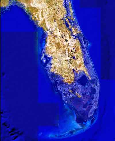
Image showing projected Florida flooding, from flood.firetree.net, using Google Earth with NASA data. Image from flood.firetree.net, using Google Earth.
Surveyors, prepare to get your feet wet. Global warming is about to hit you in the job list. By 2050, a majority of U.S. coastal areas are likely to be threatened by 30 or more days of flooding each year. This according to a December report in Earth’s Future, a journal of the American Geophysical Union.
[Parenthetically, the next issue of Survey Scene, in May, will be written by an actual geodesist. Until then, you have to put up with GPS World’s editor in chief — by no means a surveyor. Patience.]
The study used data from National Oceanic and Atmospheric Administration (NOAA) tide gauges to show the annual rate of coastal floods has accelerated in recent years. These are now five to 10 times more likely today than 50 years ago — and getting worse.
Mitigation decisions could range from retreating further inland to coastal fortification or to a combination of “green” infrastructure using both natural resources such as dunes and wetland, along with “gray” man-made infrastructure such as sea walls and redesigned storm water systems. And that’s not even mentioning such basics as redrawing property lines. Any way you look at it, surveyors are going to be involved.
“As communities across the country become increasingly vulnerable to water inundation and flooding, effective risk management is going to become more heavily reliant on environmental data and analysis,” said Holly Bamford, NOAA acting assistant secretary for conservation and management.
The recent U.S. Hydro 2015 conference in National Harbor, Maryland — an area particularly called out for vulnerability to the oncoming floods — naturally found a lot to talk about in this and related areas of interest for surveyors, with session tracks including: Effects of Climate Change on our Oceans and Waterways; Coastal and Ocean Mapping Initiatives; Advances in Unmanned System Technology, and several more.
Some of the papers presented that GPS World found of interest, and hopes to present or encapsulate in some form in the near future, include:
Resolving Systematic GPS Interference from Aeronautical Distance Measuring Equipment during Mission-Critical Shallow Water Multibeam Surveys
GPS Water-Level Buoy for Hydropgraphic Survey Operations
Examining the Uncertainty Associated with the Establishmenbt of an Ellipsoid to Chart Datum Separation Surface Using GNSS Buoys
Comparison of Horizontal and Vertical Resolvable Resolution between Repetitive Multibeam Surveys Using Different Kinematic GNSS Methods.
And those just came from the poster sessions. In the technical sessions, Jack Riley from the NOAA Coast Survey’s Hydrographic Systems and Technology Program presented a GPS Buoy Water Level Uncertainty Case Study.
Data from on High
Since you can’t get at a coastline from all angles — with any degree of stability, that is — data from overhead, sometimes far overhead, proves invaluable. Such as that provided by aerial digital imagery, LiDAR, and increasingly, satellites.
Because digital aerial images are already in electronic form, they can quickly be processed and made available to users. Most of the special cameras in use nowadays provide direct georeferencing capability, which allows camera position and orientation to be determined automatically using GPS and inertial measurement equipment. An entire mini-industry has grown up around integrating aerial data with that taken from ground surveys.
Light detection and ranging (LiDAR), a remote sensing system, became available for commercial topographic mapping in 1993. An airborne laser scanning system paired with a kinematic GPS receiver and an inertial navigation system can calculate and produce a highly accurate spot elevation. It is possible to obtain point densities that would likely take months to collect using traditional ground survey methods. The National Geodetic Survey (NGS) is currently implementing LiDAR into their shoreline mapping production process.
Our Record So Far
Coverage of these salty issues has been sparse in GPS World and associated newsletters, but not entirely absent. In 2006, the May issue featured “GPS Buoys Nautical Measurement.”
In 2008, Richard Langley edited an Innovation column on “Tsunami Detection by GPS,” featuring work for which co-author Attila Komjathy eventually won a GPS World Leadership Award in 2013. And in 2010, Langley brought forth an Innovation column on “Monitoring Water Level with GNSS.”
And way, way back in 2005, we published “Abreast of the Waves: Open-Sea Sensor to Measure Height and Direction.” This was prior to our digital era, so until we can scan a paper copy into here, we’ll simply give the abstract: “Accurate and timely information on open-sea wave conditions can help in preventing large-scale maritime disasters. This article describes a new, low-cost Global Positioning System (GPS)-based sensor that measures wave height with an accuracy of several centimeters and direction with an accuracy of 5 degrees. The receiver is mounted on a buoy, and a high-pass filter is used to extract the movement of the buoy and thus minimize GPS positioning errors. The data provided by the sensor is intended to improve wave prediction models. In addition, since this GPS-based sensor transmits only analyzed ocean wave data, it reduces the volume of data and leads to lower operating and acquisition costs. The article describes the concept of the GPS-based wave sensor, algorithms that are used for filtering and extracting wave data, as well as the results of open-sea trials.”
So there’s more to come. Watch this space. In the meantime, we leave you with Bob Dylan’s prophetic words, circa 1967.
Well, it’s sugar for sugar And salt for salt If you go down in the flood It’s gonna be your own fault.
The Compass family of geospatial companies has established Compass4Colorado, a collaborative effort to make high-tech GIS and mapping capabilities available at no or low cost to organizations involved in the recovery activities related to the devastating Colorado floods. Free flood-mapping webinars and workshops will be offered starting in October.
Compass4Colorado offers mapping software, integration services, training and expertise at no charge and equipment rentals at significantly reduced rates to public- and private-sector organizations engaged in flood assessment and recovery. The Compass4Colorado campaign will remain active through March 31, 2014, with support from four additional Colorado companies – Trimble Navigation of Westminster, Laser Technology of Centennial, DigitalGlobe of Longmont, GeoSpatial Experts of Thornton – and Esri of Redlands, California.
“Companies, utilities, and government agencies across Colorado and Nebraska are faced with assessing the full extent of flood damage as recovery begins,” said W. Brant Howard, Founder and Chairman of CompassTools. “We believe that geospatial technologies, especially mobile field data collection, can help this assessment phase proceed more quickly and accurately so the impacted communities can rebuild sooner.”
Before the flood waters had begun to recede, the Compass companies were taking urgent calls from local municipalities and utilities that needed to survey high-water lines, delineate inundation zones, and photo-map damaged assets. CompassTools found that many organizations requesting assistance with assessment activities had some in-house GPS or GIS capabilities, but they required software upgrades, equipment integration or personnel training to deploy them effectively.
“If a Colorado or Nebraska organization in the flood-affected areas doesn’t have GPS or GIS mapping capability, we will make sure they get it,” said Howard. “If they already have the technology, we’re going to make sure they can use it.”
The Compass family of companies, CompassTools, CompassCom and CompassData, are authorized distributors of products and services for Trimble, Laser Technology, DigitalGlobe, GeoSpatial Experts, and Silver Business Partners of Esri.
With support from these organizations, Compass4Colorado includes, but is not limited to, the following offerings at no charge:
Webinar (Oct. 7) and workshops (Oct. 17/Nov. 12) dedicated to field data collection techniques to support assessment and recovery efforts
One-year subscription with configuration service for Trimble Terraflex mobile data collection software
Configuration of TrimbleConnect for water/waste water inspection leveraging Esri ArcGIS Server
Integration of Laser Technology laser rangefinders into GPS data collection workflow
Integration of FEMA inspection workflow on mobile devices
Esri ArcPad and ArcMobile configuration and support
Three-month subscription to GeoSpatial Experts GeoJot+ photo-mapping application
Ground control points to support CompassData processing of DigitalGlobe flood imagery
In addition, Compass4Colorado will offer reduced rates on the following:
Trimble GPS and Laser Technology laser range finder equipment
Field inspection and assessment services
Precision orthorectified DigitalGlobe imagery
For a complete listing of all Compass4Colorado offerings and terms, visit www.Compass4Colorado.com.