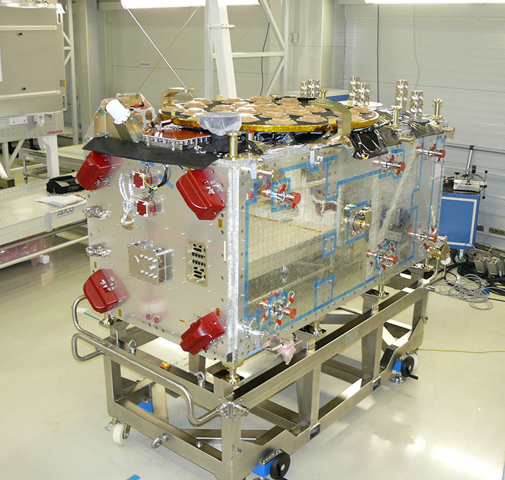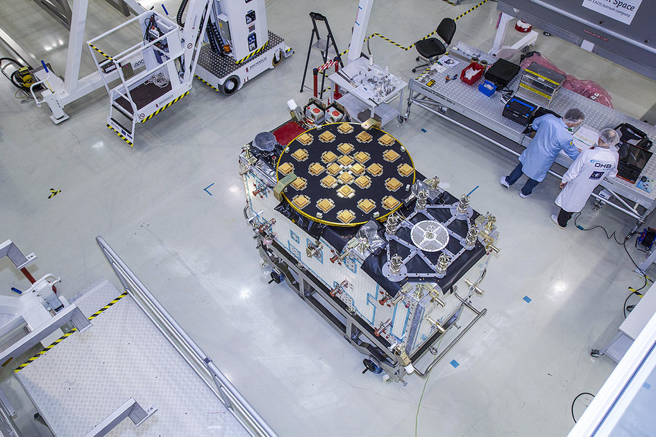
The European Space Agency (ESA) has released detailed views of the next batch of Galileo satellites, the first of which cuurently performs under simulated space conditions at the ESTEC technical center in Noordwijk, the Netherlands.
The first Galileo Full Operational Capability (FOC) satellite is functionally identical to the four Galileo In-Orbit Validation satellites already in orbit, but has been built by a separate industrial team. All 22 FOC satellites so far procured by ESA have as prime contractor OHB in Bremen, Germany; Surrey Satellite Technology Ltd. in Guildford, UK, produces the navigation payloads. The photos shown here were taken at OHB.
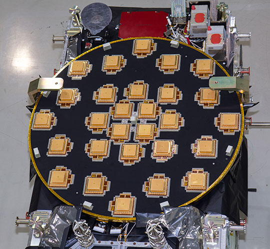
The satellite’s body measures 2.5 x 1.2 x 1.1 meters (8.2 x 3.9 x 3.6 feet), and it weighs approximately 733 kilos (1,616 pounds). Atop it in these photographs (although on the underside when orbiting Earth) is the circular L-band antenna that will continuously broadcast navigation messages.
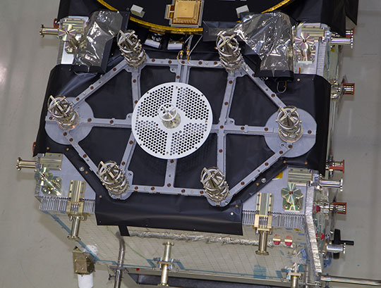
The smaller, hexagonal antenna beside it will pick up emergency messages from vessels in distress and relay location and other information to search and rescue authorities, contributing to the international Cospas–Sarsat system.
A second Galileo FOC satellite is due to also travel to ESTEC this summer, preparing for a launch later this year.
L2, L5 CNAV Testing
The U.S. Air Force Space Command began testing civil navigation (CNAV)capabilities on the GPS L2 and L5 signals on June 15 and was scheduled to continue until June 29. Civil users and manufacturers were invited to participate.
According to the GPS Directorate, the CNAV live-sky testing program will span several years and will evolve to support GPS enterprise and modernized civil navigation performance objectives. Objectives include:
◾ Verify and validate the CNAV requirements specified IS-GPS-200F and IS-GPS-705B.
◾ Facilitate the development of robust IS-compliant L2C and L5 civil receivers.
More information about the testing is available in a 52-page PDF, including sections on test strategy, event conditions and constraints, operational environment, test support resources and data collection, evaluation methodology, risk assessment, and reporting.
The L2 CNAV data is an upgraded version of the original NAV navigation message. It contains higher precision representation and nominally more accurate data than the NAV data. Two out of every four packets are ephemeris data and at least one of every four packets will include clock data, but the design allows for a wide variety of packets to be transmitted. Only a fraction of the available packet types have been defined; this enables the system to grow and incorporate advances.
One packet contains a GPS-to-GNSS time offset, enabling interoperability with other global time-transfer systems such as Galileo and GLONASS, both of which are supported. The extra bandwidth enables the inclusion of a packet for differential correction. Every packet contains an alert flag, to be set if the satellite data cannot be trusted. Users will know within six seconds if a satellite is no longer usable, important data for safety-of-life applications such as aviation.
The system is designed to support 63 satellites, compared with 32 in the L1 NAV message.
Possible New GPS Launch Option
The U.S. Air Force Space and Missile Systems Center (SMC) has signed a Cooperative Research and Development Agreement with Space Exploration Technologies Corp., better known as SpaceX, as part of the company’s effort to certify its Falcon 9 v1.1 Launch System for National Security Space (NSS) missions.
SMC and SpaceX will look at the Falcon’s flight history, vehicle design, reliability, safety systems, and other aspects. Once the evaluation is complete, the SMC commander will determine whether SpaceX has the capability to successfully launch NSS missions using the Falcon 9 v1.1.
Currently, United Launch Alliance’s Delta IV and Atlas V are the only certified launch vehicles capable of lifting NSS payloads — such as the GPS satellites — into orbit. The addition of multiple certified launch vehicles provides more options to place needed capabilities on orbit. While certification does not guarantee a contract award, it does enable a company to compete for launch contracts. Those contracts could be awarded as early as Fiscal Year 2015 with launch services provided as early as FY 2017.
GPS III Funds Cut, GPS IV on Horizon?
According to a U.S. Department of Defense (DoD) spending plan released on June 1, space programs were relatively protected in an environment of across-the-board budget cuts known as sequestration. Specifically, although the budget for GPS III has been reduced for both 2013 and 2014, the reductions still allow the proposed program to stay on course. The cuts amount to about $58 million from GPS III and its associated ground system.
Congressional lawmakers proposed spending $77 million less next year for the GPS III satellite and ground systems than proposed by the Air Force, which asked for nearly $1.1 billion.
Currently, the Air Force has eight GPS III satellites contracted with Lockheed Martin Space Systems, and current plans call for the purchase of 12 further satellites with improved capabilities.
GPS IV. Gen. William Shelton, commander of Air Force Space Command, floated the possibility of a new look for the constellation on Capitol Hill. In an April 25 House hearing, Shelton said the Air Force will study this fall whether to buy another 12 GPS III craft or move on to a new generation of satellites.
“Would it be better to continue [GPS III] as opposed to starting a whole new fourth generation?” asked Representative Doug Lamborn of Colorado. “That’s the decision we will have to make in the fall,” replied Shelton. “It seems like the answer would be ‘yes’ but we will study that.”
A key aspect of the next-next gen satellite would have to be dual-launch capability. The reduction in expense this would furnish is in higher and higher demand as time goes by. Both Lockheed and Boeing are reportedly in talks with the Air Force regarding IV.
System Briefs
GLONASS Embezzle Imbroglio. The Russian Federal Security Service is investigating the embezzlement of billions of rubles from the construction of the GLONASS center in Korolyov, a town outside Moscow, as reported by Izvestia.
Construction of the GLONASS control and support center began in June 2010 on the site used by TsNIImash, the head research company of Russia’s federal space agency. The center was supposed to hold equipment for collecting and processing the data supplied by the GLONASS global network.
The construction was financed by a federal program, with 1.050 billion ($33.22 million) allocated for the project. By the end of 2010, it came to light that construction costs had been overstated, Izvestia reports. An expert appraisal revealed that the contractor had rigged the costs. The government did not allocate additional funds, so construction was suspended in December 2011 when the Federal GLONASS Program for 2002-–2011 ended. The construction of the building has never been completed.
In November 2012, the general designer of GLONASS, Yuri Urlichich, was dismissed from his post as a result of the scandal.
IRNSS Nav Center, July Launch. The Indian Space Research Organization (ISRO) Navigation Centre for the Indian Regional Navigation Satellite System (IRNSS) was inaugurated May 28, at the Deep Space Network complex at Byalalu, near Bangalore, India.
IRNSS, an independent navigation satellite system being developed by India, will have a constellation of seven satellites in geostationary and inclined geosynchronous orbits. IRNSS coverage will extend over India and the southeast Asia region. The ISRO Navigation Centre (INC) is responsible for providing the time reference, generation of navigation messages, and monitoring and control of ground facilities including ranging stations of IRNSS. IRNSS will establish a network of 21 ranging stations geographically distributed primarily across India to provide data for the orbit determination of IRNSS satellites and monitoring of the navigation signals.
On June 15, India’s Economic Times reported that a new launch date (postponed from previously announced June 11) was set for IRNSS-R1A or 1A, the first IRNSS satellite: July 1 at 18:13 UTC.
Beidou Jammed. A Beidou satellite is now believed to have experienced interference from a complex electromagnetic environment, which cut off signal transmissions in 2007, China’s People’s Daily reported. A team of scientists was able to overcome the interference issue in less than three months by 2008.
Wang Feixue, a scientist specializing in the Beidou navigation system and a senior colonel in the People’s Liberation Army said, “Had they not been able to recover the signal within three months, future satellite launches would have been indefinitely delayed. And satellites already launched would have been put out of operation.”
EGNOS Contract. A new European Geostationary Navigation Overlay Service (EGNOS) service provision contract was signed June 26 at the European Commission Vice President Antonio Tajani’s office in Brussels. The contractee is again the European Satellite Services Provider (ESSP), founded in 2001and in 2008 transformed into ESSP SAS and moved from Brussels to Toulouse.
Its shareholders are seven European air navigation service providers: Aeropuertos Espanoles y Navegacion Aerea (Spain), Deutsche Flugsicherung GmbH (Germany), Direction générale de l’Aviation civile (France), Ente Nazionale Di Assistenza Al Volo (Italy), National Air Traffic Services (UK), Navegação Aérea de Portugal, and Skyguide (Switzerland).