Tag: Galileo FOC anomaly

  • The System: eLoran Operational on Eastern UK Coast

    The System: eLoran Operational on Eastern UK Coast

    Bridge of the Galatea, a GLA vessel that carries a eLoran receiver and conducted tests of the new system.
    Bridge of the Galatea, a GLA vessel that carries a eLoran receiver and conducted tests of the new system. Photo: GLA

    Back-up to Vulnerable GPS Signals Required for Busy Shipping Lanes

    The General Lighthouse Authorities (GLAs) of the UK and Ireland announced October 31 the initial operational capability of UK maritime eLoran. Seven differential reference stations now provide additional position, navigation, and timing (PNT) information via low-frequency pulses to ships fitted with eLoran receivers. The service will help ensure they can navigate safely in the event of GPS failure in one of the busiest shipping regions in the world, with expected annual traffic of 200,000 vessels by 2020.

    Ships carry 95 percent of UK trade, accounting for its strongly expressed concerns regarding GPS vulnerability to jamming and spoofing, and the leadership role it has taken in eLoran research and testing. The UK is the first country in the world to deploy the technology along its coastline, thronged with both passenger and cargo services. Deployment involved replacing the existing radio receiver equipment in two prototype reference stations at Dover and Harwich, and the creation of five new reference stations in the Thames, Humber, Middlesbrough, and Firth of Forth and Aberdeen in Scotland, on the North Sea where oil-laden vessels come from deep-sea drilling rigs.

    Entirely independent of GPS, eLoran can provide navigation information for vessels as well as the timing data necessary to maintain the power grid, cell phones, financial networks, and the Internet in the event of an outage. Unlike space-based navigation, eLoran signals can also reach inside buildings, underground, and underwater.

    Captain Ian McNaught, deputy master of Trinity House, commented, “eLoran provides a signal around 1 million times more powerful than those from satellite signals, providing resilience from interference and attack. The achievement of initial operational capability for the system at Dover and along the east coast of the UK is a significant milestone, providing for improved safety aboard appropriately equipped vessels. The maritime industry would now benefit from the installation of eLoran receivers on more vessels to take advantage of improved navigational safety.”

    “Telecoms, finance, energy, and other industries, which are subject to significant issues caused by the loss of timing signal provided by GPS, are recommended to take advantage of the enhanced reliability now available to address the over-dependence of key national infrastructure on vulnerable satellite systems,” McNaught said.

    eLoran technology is based on longwave radio signals and is independent and complementary to GPS.

    Several other nations are consulting with the UK GLAs on eLoran. South Korea wants to establish an eLoran alliance with the UK while it pursues its own rollout of differential eLoran reference stations and new eLoran transmitters based on the latest technology. In 2012, South Korea was the victim of a 16-day GPS jamming attack by North Korea.

    Full operational capability covering all major UK ports is expected by 2019.

    Galileo Roving High

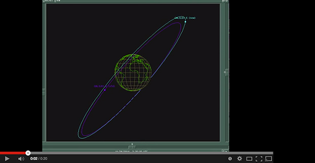
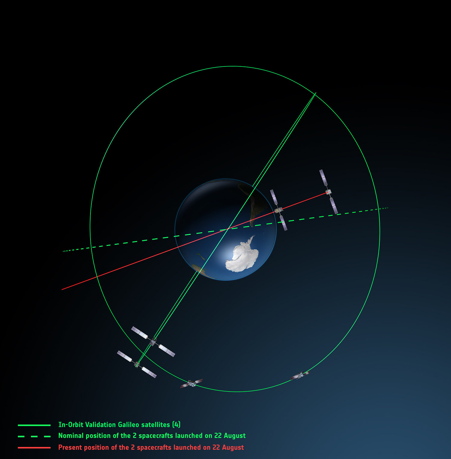
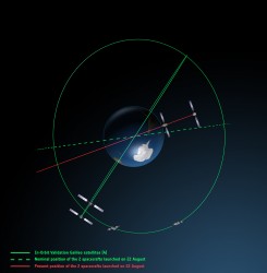
    The fifth Galileo navigation satellite, one of two left in the wrong orbit in August, made a series of November maneuvers as a prelude to its health being confirmed. The aim was to raise the lowest point of its orbit — its perigee — to reduce the radiation exposure from the Van Allen radiation belts surrounding Earth, as well as to put it into a more useful orbit for navigation purposes.

    Should the two-week operation prove successful, the sixth Galileo satellite will follow the same route, according to the European Space Agency (ESA).

    The Galileo pair, launched together on a Soyuz rocket on August 22, ended up in an elongated orbit traveling out to 25,900 kilometers (km) above Earth and back down to 13,713 km. The target orbit was a purely circular one at an altitude of 23,222 km. Also, the orbits are angled relative to the Equator less than originally planned.

    The two satellites have only enough fuel to lift their altitude by about 4,000 km — insufficient to correct their orbits entirely. But the move will take the fifth satellite into a more circular orbit than before, with a higher perigee of 17,339 km.

    “The new orbit will fly over the same location every 20 days,” said Daniel Navarro-Reyes, ESA Galileo mission analyst. “The standard Galileo repeat pattern is every 10 days, so achieving this will synchronize the ground track with the rest of the Galileo satellites.”

    “In addition, from a user receiver point of view, the revised orbit will reduce the variation in signal levels, reduce the Doppler shift of the signal, and increase the satellite’s visibility,”  Navarro-Reyes said. “For the satellite, reducing its radiation exposure in the Van Allen radiation belts will protect it from further exposure to charged particles. The orbit will also allow Galileo’s Earth Sensor to hold a stable direction for the satellite’s main antenna to point at Earth. Right now, when the satellite dips to its lowest point, Earth appears so large that the sensor is unusable. The satellite relies on gyroscopes alone, degrading its attitude precision.”

    The recovery is being overseen from the Galileo Control Centre in Oberpfaffenhofen, Germany, with the assistance of ESA’s Space Operations Centre, ESOC, in Darmstadt, Germany. France’s CNES space agency is providing additional ground stations so that contact can be maintained with the satellite as needed, ESA said.

    Welcome IIF-8

    The U.S. Air Force launched the eighth GPS IIF satellite on October 29, aboard an Atlas V 401 rocket. With this new arrival on orbit, only four more Block IIF satellites remain to be placed aloft. Three are in storage awaiting launch, and one is in production.

    The Boeing-built GPS IIF-8 (SVN-69/PRN-03) will replace SVN-51 in the E plane slot 1. SVN-51 will be re-phased from E1 to an auxiliary node at E7 somewhere around SVN-54 currently on station at E4, according to the Air Force Second Space Operations Squadron (2 SOPS).  SVN-38/PRN-08 will be taken out of the operational constellation prior to SVN-69 payload initialization and sent to Launch, Anomaly Resolution and Disposal Operations (LADO).  PRN-08 will be assigned initially to SVN-49 and set to test.

    SVN-51 will remain in an auxiliary node once it completes its re-phase journey. The SVN-51 re-phase will take about six months after the initial burn occurs.

  • Directions 2015: Galileo Looks Ahead to Early Services

    GPS-directions-GalileoThe European GNSS Agency (GSA) hosted the ninth meeting of the International Committee on Global Navigation Satellite Systems (ICG) in November at its headquarters in Prague, Czech Republic. The event is an opportunity for GNSS providers to present the status and future plans for their systems, and an opportunity for ICG members, associate members, and observers to provide updates on recent developments with regard to GNSS services and applications.

    Representatives from the world’s leading global and regional GNSS programs were invited to provide the assembly with a “state of play” for their respective systems. Joining GPS, GLONASS, BeiDou, IRNSS/GAGAN, and QZSS was Galileo, represented by Christian Siebert, Head of Unit, Galileo and EGNOS: Applications, Security and International Cooperation, DG Enterprise and Industry, European Commission.

    A Secure Foundation

    The key message coming from Prague was that, despite the launch anomaly in August, the Galileo program has a secure foundation for moving forward. For instance, it has been given a stable seven-year perspective, a substantial budget, and a new exploitation-driven governance scheme. In terms of budget, the European Commission has allocated €1.930 billion for deployment and €3 billion for exploitation — with an additional €1.580 billion allocation for European Geostationary Navigation Overlay Service (EGNOS) exploitation.

    The new governance scheme is based on a recently announced agreement between the European Commission and the GSA; the agreement delegates a range of exploitation tasks for Galileo to the GSA. Serving as an initial step towards the full Galileo Exploitation Phase, the GSA’s responsibilities now include:

    • provision and marketing of the services;
    • management, maintenance, continuous improvement, evolution and protection of the space and ground infrastructure;
    • research and development of receiver platforms with innovative features in different application domains;
    • development of future generations of the system;
    • cooperation with other GNSS;
    • all other required activities to ensure the development and smooth running of the system.

    This new budget and governance structure ensures the Galileo program’s stability for the next seven years, according to a GSA press release. The agency will progressively manage exploitation activities as delegated by the European Commission, which serves as the program’s supervisor.

    At the same time, the European Space Agency (ESA) will continue its role for system design and development.

    A Range of Successes

    “The past year has seen the program achieve a range of milestones,” said Siebert. “The Galileo In-Orbit Validation Phase was successfully concluded, the ground infrastructure deployment finalized for initial operations, and the new satellite design qualified.”

    Even with the satellite launch anomaly that left two satellites in the wrong orbit, the ESA just announced that one of these satellites will soon make a series of maneuvers as a prelude to its health being confirmed. The aim is to raise the lowest point of its orbit — its perigee — to reduce the radiation exposure from the Van Allen radiation belts surrounding Earth, as well as put it into a more useful orbit for navigation purposes. If the operation is successful, the second satellite will follow suit.

    As to the cause of the anomaly itself, Siebert said Arianespace has established an inquiry board to investigate, and the European Commission and ESA continue to analyze the best options for recovering the initial mission to the best possible extent. A new launch sequence will be confirmed in the near future.

    That being said, the deployment plan for the Galileo constellation is secured, with 26 satellites ordered (four IOV and 22 FOC) and launcher service contracts for the full constellation signed with Arianespace. As to the new satellite design, production proceeds at a good pace, with full operational capability (FOC) satellites being built by OHB Systems and navigation payloads provided by Surrey Satellite Technology Ltd.

    In terms of services, the Search and Rescue Forward Link Alert Service successfully tested the networked ground segment last April, and positioning accuracy exceeds expectations.

    As to the Commercial Services Demonstrator, the main objective of the demonstrator was to test and characterize the high accuracy and authentication performance obtainable with the Galileo Commercial Service. The first results are extremely promising, with high accuracy already demonstrated through PPP information transmitted via E6B and used to enhance both Galileo and GPS. 

    Siebert noted that the ongoing Receiver Test Campaign supports manufacturers to ensure that Galileo is well implemented in chipsets and receivers. To accomplish this, the program continues to develop dialogs with the user/receiver segment to understand the market situation and follow up adoption of Galileo.

    Looking Ahead

    With this secure foundation, looking towards 2015 and beyond, Galileo is set to deliver a reliable, high-quality service to the world, according to EC and ESA spokespersons presenting at the ICG. “With its substantial budget and exploitation-focused governance scheme, it will continue to evolve and introduce innovative features,” Siebert affirmed.

    Next steps for the program include a gradual introduction of the early phase of service delivery, which will rely heavily on interaction with users. Early services will be run with continued infrastructure deployments. The program will soon conduct a service validation campaign, along with finalizing the Commercial Service definition and developing a long-term service plan. 

    “This service plan will be aligned with the trend of most user communities moving towards service levels based on a multi-constellation approach,” concluded Siebert. “Knowing this, it is crucial to continue to improve signal compatibility and interoperability of the Galileo service with other providers and cooperate on building multi-constellation programs.”

    Group-ICG-2014
    Photo: Galileo
  • Orbit of One Wayward Galileo Satellite Raised

    Orbit of One Wayward Galileo Satellite Raised

    The orbit of one of the two Galileo satellites launched into incorrect orbits on August 22 is being adjusted. Tracking data supplied by the North American Aerospace Defense Command (NORAD) and the U.S. Joint Space Operations Center (JSpOC) has confirmed the change.

    Also, the first navigation signal from Galileo 5 has been received.

    The satellites were supposed to go into circular orbits with an inclination to the equator of 56 degrees and with a semi-major axis of about 29,600 km. They ended up in eccentric orbits with semi-major axes more than 3,300 km shorter and with an inclination of about 49.7 degrees.

    Instead of an orbital height of 23,222 km above the surface of the Earth, they were moving between apogee heights of about 25,900 km and perigee heights of about 13,800 km, perilously close to the most dangerous regions of the Van Allen radiation belts.

    The European Space Agency announced on November 10 that the orbit of one of the two wayward satellites, Galileo 5, would have its perigee raised to 17,339 km through a series of 15 orbital maneuvers. This orbital adjustment would put the satellite into a safer orbit and potentially make it useable for positioning and navigation. If the operation is successful, Galileo 6 will follow suit.

    These maneuvers likely started on or shortly after November 8. After the maneuvers began, NORAD/JSpOC temporarily “lost” the satellite as often happens when satellites undergo unpredicted Delta-V operations. NORAD/JSpOC recovered the satellite after about 18 days and issued new orbital elements for the satellite on November 25.

    The new elements show that (so far) the perigee of Galileo 5 has been raised from about 13,820 km to 17,230 km with a corresponding change in the orbital eccentricity from about 0.23053 to 0.15619. The apogee height is virtually the same as that immediately after launch. Also, the inclination is not and will not be materially changed.

    An animation, produced using the NORAD/JSpOC orbital element sets and the XEphem software, compares Galileo 5’s old and new orbits:

  • Misplaced Galileo Satellite Moving to New Orbit

    Misplaced Galileo Satellite Moving to New Orbit

    The fifth Galileo satellite is now pointing toward Earth. Photo: Galileo
    The fifth Galileo satellite is now pointing toward Earth. Photo: Galileo

    The fifth Galileo navigation satellite, one of two left in the wrong orbit this summer, will make a series of maneuvers this month as a prelude to its health being confirmed. The aim is to raise the lowest point of its orbit — its perigee — to reduce the radiation exposure from the Van Allen radiation belts surrounding Earth, as well as to put it into a more useful orbit for navigation purposes.

    Should the two-week operation prove successful, the sixth Galileo satellite will follow the same route, according to the European Space Agency (ESA).

    The Galileo pair, launched together on a Soyuz rocket on August 22, ended up in an elongated orbit traveling out to 25,900 km above Earth and back down to 13,713 km. The target orbit was a purely circular one at an altitude of 23,222 km. Also, the orbits are angled relative to the equator less than originally planned.

    The two satellites have only enough fuel to lift their altitude by about 4,000 km — insufficient to correct their orbits entirely. But the move will take the fifth satellite into a more circular orbit than before, with a higher perigee of 17,339 km.

    “The new orbit will fly over the same location every 20 days,” said Daniel Navarro-Reyes, ESA Galileo mission analyst. “The standard Galileo repeat pattern is every 10 days, so achieving this will synchronize the ground track with the rest of the Galileo satellites.”

    “In addition, from a user receiver point of view, the revised orbit will reduce the variation in signal levels, reduce the Doppler shift of the signal, and increase the satellite’s visibility,”  Navarro-Reyes said. “For the satellite, reducing its radiation exposure in the Van Allen radiation belts will protect it from further exposure to charged particles. The orbit will also allow Galileo’s Earth Sensor to hold a stable direction for the satellite’s main antenna to point at Earth. Right now, when the satellite dips to its lowest point, Earth appears so large that the sensor is unusable. The satellite relies on gyroscopes alone, degrading its attitude precision.”

    The recovery is being overseen from the Galileo Control Centre in Oberpfaffenhofen, Germany, with the assistance of ESA’s Space Operations Centre, ESOC, in Darmstadt, Germany. France’s CNES space agency is providing additional ground stations so that contact can be maintained with the satellite as needed, ESA said.

    The two satellites were previously Sun-pointing. “On 3 November that changed for the fifth satellite, as it transitioned to normal Earth-pointing mode,” added Daniel.

    During November, some 15 maneuvers will take the satellite into its new orbit. Once there, it can formally begin in-orbit testing. The host satellite’s health is checked first, followed by more detailed navigation payload testing, ESA said.

    Galileo orbits viewed from above: Orbits of the fifth and sixth satellites in red, compared to their intended position in dashed green, and the position of the four satellites launched in 2011 and 2012 in solid green. This view looks down over the South Pole to illustrate how the inclination relative to the equator is less than intended. The satellites are in an elliptical rather than circular orbit, with a maximum altitude of about 25,900 km and a minimum altitude of about 13,700 km, compared to a planned circular orbit of 23,222 km altitude.  Photo: Galileo
    Galileo orbits viewed from above: Orbits of the fifth and sixth satellites in red, compared to their intended position in dashed green, and the position of the four satellites launched in 2011 and 2012 in solid green. This view looks down over the South Pole to illustrate how the inclination relative to the equator is less than intended. The satellites are in an elliptical rather than circular orbit, with a maximum altitude of about 25,900 km and a minimum altitude of about 13,700 km, compared to a planned circular orbit of 23,222 km altitude. Photo: Galileo
    Galileo orbits viewed side-on: The fifth and sixth Galileo satellites in red, compared to their intended position in dashed green, and the position of the four satellites launched in 2011 and 2012, in solid green. This view looks side on to the two satellites’ orbital plane, which is off-center relative to Earth. The targeted orbit was circular, inclined at 55º to the equator at an altitude of 23,222 km.They are in a safe state, correctly pointing towards the Sun, properly powered and fully under control of an ESA–CNES team. Photo: Galileo
    Galileo orbits viewed side-on: The fifth and sixth Galileo satellites in red, compared to their intended position in dashed green, and the position of the four satellites launched in 2011 and 2012, in solid green. This view looks side on to the two satellites’ orbital plane, which is off-center relative to Earth. The targeted orbit was circular, inclined at 55º to the equator at an altitude of 23,222 km.They are in a safe state, correctly pointing towards the Sun, properly powered and fully under control of an ESA–CNES team. Photo: Galileo


  • The System: Fregat Design Ambiguity Steered Galileo Wrong

    Cross-Installed Hydrazine, Helium Lines Froze Thrusters

    The root cause of the anomaly that sent two Galileo satellites into the wrong orbit on August 22 was a shortcoming in the system thermal analysis performed during stage design, and not an operator error during stage assembly, according to findings by an independent inquiry board.

    The independent inquiry board was created by Arianespace, in conjunction with the European Space Agency and the European Commission. Its conclusions draw on data supplied by Russian partners in the program, and are consistent with the final conclusions of the inquiry board appointed by the Russian space agency Roscosmos.

    The anomaly occurred during the flight of the launcher’s fourth stage, Fregat, designed and produced by NPO Lavochkin. It occurred about 35 minutes after liftoff, at the beginning of the ballistic phase preceding the second ignition of this stage.

    The board’s conclusions confirm that the first part of the mission proceeded nominally, which means that the three-stage Soyuz launcher was not at fault. The inquiry board also eliminated the hypothesis that the anomaly could have been caused by the abnormal behavior of the Galileo satellites.

    The scenario that led to an anomaly in the orbital injection of the satellites was precisely reconstructed, as follows:

    The orbital error resulted from an error in the thrust orientation of the main engine on the Fregat stage during its second powered phase.

    This orientation error was the result of the loss of inertial reference for the stage.

    This loss occurred when the stage’s inertial system operated outside its authorized operating envelope, an excursion that was caused by the failure of two of Fregat’s attitude-control thrusters during the preceding ballistic phase.

    This failure was due to a temporary interruption of the joint hydrazine propellant supply to these thrusters. The interruption in the flow was caused by freezing of the hydrazine.

    The freezing resulted from the proximity of hydrazine and cold helium feed lines, these lines being connected by the same support structure, which acted as a thermal bridge.

    Ambiguities in the design documents allowed the installation of this type of thermal “bridge” between the two lines. In fact, such bridges have also been seen on other Fregat stages now under production at NPO Lavochkin.

    The design ambiguity is the result of not taking into account the relevant thermal transfers during the thermal analyses of the stage system design.

    The system thermal analyses have been reexamined in depth to identify all areas concerned by this issue. The board has chosen these corrective actions for the return to flight.

    • Revamp of the system thermal analysis.
    • Associated corrections in the design documents.
    • Modification of the documents for the manufacture, assembly, integration, and inspection procedures of the supply lines.

    Arianespace said these measures can immediately be applied by NPO Lavochkin to the stages already produced, meaning that the Soyuz launcher could be available for its next mission from the Guiana Space Center in December.

    “We are looking at the resumption of Soyuz launches from the Guiana Space Center, as early as December 2014,” stated the Arianespace CEO. “The resolution of this anomaly will enable a consolidation of the reliability of Fregat, which had experienced 45 consecutive successes until this mission.” 

    Galileo Service Controls Handed to GNSS Agency

    Full Operability Set for 2020

    The European GNSS Agency (GSA) and the European Commission have concluded an agreement that delegates a range of exploitation tasks for Galileo to the GSA, providing a framework and budget for the development of services and operations through 2021.

    The signing of the Galileo Exploitation Delegation Agreement serves as an initial step towards the full Galileo Exploitation Phase. According to the governance structure set out in the agreement, the European Commission is responsible for the overall programme supervision, the European Space Agency (ESA) is entrusted with the deployment phase, while the GSA is responsible for the exploitation phase. The GSA’s responsibilities include:

    • provision and marketing of the services
    • management, maintenance, continuous improvement, evolution and protection of the space and ground infrastructure
    • research and development of receiver platforms with innovative features in different application domains
    • development of future generations of the system
    • cooperation with other GNSS
    • all other required activities to ensure the development and smooth running of the system.

    “With Galileo, we aim to provide a tangible service to European citizens, and this Delegation Agreement ensures we have the tools and funding necessary to achieve this,” said GSA Executive Director Carlo des Dorides.

    Full operability of Galileo is now scheduled for 2020, a slight revision of the previous 2018 projection.

    The agreement specifically sets the actions to be implemented, the amount of funding provided, and the conditions for the overall management. The maximum current EU contribution amounts to EUR 490 million, which will cover procurement and grant activities, including the GSA-ESA working arrangements and a programme management reserve, along with related research and development activities. The financing of the full exploitation phase will be confirmed during a mid-term review before the end of 2016.

    India Launches Third Satellite and ICD

    India successfully launched IRNSS-1C, the third satellite in the Indian Regional Navigation Satellite System (IRNSS), on October 16. The satellite was injected to an elliptical orbit of 282.56 x 20,670 kilometers, very close to its intended final geostationary orbit at 83 degrees East longitude. 

    IRNSS-1C is the third of the seven satellites constituting the space segment of the Indian Regional Navigation Satellite System. Tthe first two were launched in July 2013 and April of this year. Both are functioning satisfactorily from their designated geosynchronous orbital positions. 

    IRNSS is an independent regional navigation satellite system designed to provide position information in the Indian region and 1,500 kilometers around the Indian mainland. IRNSS will provide two types of services: Standard Positioning Services (SPS), provided to all users, and Restricted Services (RS), provided to authorized users. Ground stations have been established in at least 15 locations across India.

    The next satellite of the constellation, IRNSS-1D, is scheduled to be launched in the coming months. The full IRNSS constellation of seven satellites is planned to be completed by 2015.

    IRNSS ICD Released. In late September, the Indian Space Research Organization (ISRO) released version 1 of the IRNSS Signal in Space Interface Control Document (ICD) for the Standard Positioning Service.

    The document provides information on the signals and structures of the IRNSS system, including signal modulations, frequency bands, received power levels, the data structures and their interpretations, and user algorithms.

    Registration is required for ICD download access at a new IRNSS website

    JAVAD Tracks Signal. JAVAD GNSS published a chart showing that it has tracked the IRNSS L5 signal.

    Shortly after ISRO released its IRNSS Signal in Space Interface Control Document (ICD), JAVAD GNSS tracked the L5 BPSK signal from both 1A and 1B satellites. Ability to track IRNSS L5 will be added to all JAVAD L5-capable receivers in the near future, the company said.

    SNR of two passes of 1A satellite (IGSO) over Moscow.
    SNR of two passes of 1A satellite (IGSO) over Moscow.

    Let’s All Be GPS III for Halloween

    As this magazine goes to press on October 23, the U.S. Air Force is set to launch the eighth GPS IIF satellite from Cape Canaveral Air Force Station on Wednesday, October 29.  An 18-minute launch window will open at 1:21 p.m. U.S. Eastern time. If all goes well, the satellite will be accomplishing its early-orbit checkouts and beginning maneuvers towards its final orbital plane as U.S. children make their costumed Halloween rounds, collecting candy. Other Western countries celebrate All Hallows’ Eve followed by All Saints’ Day on November 1.

  • Galileo Team Raced to Respond Following FOC Launch

    Galileo Team Raced to Respond Following FOC Launch

    Flight Operations Director Hervé Côme celebrating success finding the satellites. Photo: Galileo Control Centre
    Flight Operations Director Hervé Côme celebrating success finding the satellites. Photo: Galileo Control Centre

    On September 27, the first two Galileo Full Operational Capability (FOC) satellites were handed over from the European Space Agency’s Space Operations Centre (ESOC) in Darmstadt, Germany, to the Galileo Control Centre, Oberpfaffenhofen, which will care for them pending a final decision on their use.

    The satellites, launched on August 22, are in excellent health and working normally. However, a launcher problem left the pair in the wrong orbit, with higher apogee, lower perigee and an incorrect inclination compared to the planned circular orbit.

    According to a release by the European Space Agency, the orbit presented a sudden and unexpected — though not untrained for — challenge to the team at ESOC responsible for the launch and early orbit phase. For months before each Galileo launch, a joint team of mission operations experts from ESA and France’s CNES space agency train intensively for this critical period, which typically lasts about eight days, from separation until handover to Oberpfaffenhofen.

    “After launch, we quickly discovered that one of each satellite’s pair of solar wings had not deployed correctly,” said Liviu Stefanov, Spacecraft Operations manager. “At the same time, difficulties in receiving radio signals — indicated by unusually low power and instability — alerted us to the fact that the orbits could be incorrect. Basically, the ground stations were pointing to where we expected the satellites to be, and they weren’t there, so we weren’t getting good signals.”

    The joint ESA–CNES Galileo operations team in the Main Control Room at ESA’s Space Operations Center, August 28. (Photo credit: R. Solaz).
    The joint ESA–CNES Galileo operations team in the Main Control Room at ESA’s Space Operations Center, August 28. (Photo credit: R. Solaz).

    Engineers determined within four hours the approximate actual orbit and then generated new commands to point the ground antennas to establish robust radio links. Working around the clock, and with assistance from the Galileo project engineers and the satellite builder, the teams then started to look at how to free the solar arrays. “Each undeployed wing had to be treated as a separate problem,” said Flight Operations Director Hervé Côme.

    “Each satellite had to be maneuvered separately into an orientation where the undeployed panel was facing the Sun because we realized that one cause was linked to the low temperature of the release mechanism. It all required developing, validating and rehearsing new flight operation procedures on the fly.”

    It took three days to release the trapped solar wing of the first satellite, and then two days later the second Galileo’s stuck array was also freed. The satellites have since been brought into full operation, as the teams in Darmstadt were tasked to retain control for five weeks — four weeks longer than planned.

    “This was very demanding on the ESA and CNES personnel, and on the ESOC operations team in particular, but the strong bonds developed through months of joint training enabled them to perform very well,” Liviu said.

    Possible uses of the two satellites are now being studied, and a future mission scenario will be decided at a later date.

    While the process of handing over the satellites to the Galileo Control Centre (where they are operated by teams from a private company, spaceopal GmbH), had been practiced in the past, this was the first time it was done with FOC satellites in orbit. The delicate process involves transferring responsibility for commands and telemetry, and beginning the satellites’ secure mode of operation by the teams at Oberpfaffenhofen. The handover ran very smoothly over the last weekend in September.

    “By the end of the Saturday, the first satellite was fully handed over, while the second handover took place on Sunday,” said Richard Lumb, ESA’s Galileo Mission director.

    “I am extremely proud of the entire Mission Control Team and the way they handled a dramatic and very critical situation resulting from multiple, independent anomalies,” said Paolo Ferri, ESA’s head of Mission Operations. “After launch, the joint team managed to maintain control of the satellites under extremely difficult conditions, rapidly stabilized them, and determined the actual orbit. The accuracy and professionalism of the subsequent handover activities also showed that the joint team at ESOC and the spaceopal team at the Galileo Control Centre are very well tuned for this procedure, which will become increasingly frequent with future launches.”

  • Galileo FOC Anomaly Traced to Design Ambiguity, Says Inquiry Board

    The root cause of the anomaly that sent two Galileo satellites into the wrong orbit is a shortcoming in the system thermal analysis performed during stage design, and not an operator error during stage assembly, according to findings by an independent inquiry board.

    The Independent Inquiry Board was formed to analyze the causes of the anomaly occurring during the orbital injection of satellites in the Galileo constellation by a Soyuz rocket launched from the Guiana Space Center on August 22. The board announced its definitive conclusions on Tuesday following a meeting at Arianespace headquarters in Evry, near Paris.

    The board was created on August 25 by Arianespace, in conjunction with the European Space Agency and the European Commission. It is chaired by Peter Dubock, former inspector-general of ESA. Its conclusions draw on data supplied by Russian partners in the program, and are consistent with the final conclusions of the inquiry board appointed by the Russian space agency Roscosmos.

    The anomaly occurred during the flight of the launcher’s fourth stage, Fregat, designed and produced by NPO Lavochkin. It occurred about 35 minutes after liftoff, at the beginning of the ballistic phase preceding the second ignition of this stage.

    The board’s conclusions confirm that the first part of the mission proceeded nominally, which means that the three-stage Soyuz launcher was not at fault. The Inquiry Board also eliminated the hypothesis that the anomaly could have been caused by the abnormal behavior of the Galileo satellites.

    The scenario that led to an anomaly in the orbital injection of the satellites was precisely reconstructed, as follows:

    • The orbital error resulted from an error in the thrust orientation of the main engine on the Fregat stage during its second powered phase.
    • This orientation error was the result of the loss of inertial reference for the stage.
    • This loss occurred when the stage’s inertial system operated outside its authorized operating envelope, an excursion that was caused by the failure of two of Fregat’s attitude control thrusters during the preceding ballistic phase.
    • This failure was due to a temporary interruption of the joint hydrazine propellant supply to these thrusters. The interruption in the flow was caused by freezing of the hydrazine.
    • The freezing resulted from the proximity of hydrazine and cold helium feed lines, these lines being connected by the same support structure, which acted as a thermal bridge.
    • Ambiguities in the design documents allowed the installation of this type of thermal “bridge” between the two lines. In fact, such bridges have also been seen on other Fregat stages now under production at NPO Lavochkin.
    • The design ambiguity is the result of not taking into account the relevant thermal transfers during the thermal analyses of the stage system design.

    The system thermal analyses have been reexamined in depth to identify all areas concerned by this issue. Given this identified and perfectly understood design fault, the board has chosen the following corrective actions for the return to flight.

    • Revamp of the system thermal analysis.
    • Associated corrections in the design documents.
    • Modification of the documents for the manufacture, assembly, integration and inspection procedures of the supply lines.

    Arianespace said these measures can easily and immediately be applied by NPO Lavochkin to the stages already produced, meaning that the Soyuz launcher could be available for its next mission from the Guiana Space Center as from December 2014.

    Beyond theses corrective actions, sufficient for return to flight, NPO Lavotchkin will provide Arianespace with all useful information regarding Fregat’s design robustness, which is proven by 45 successful consecutive missions before this anomaly.

    Following the announcement of the Independent Inquiry Board’s conclusions, Stéphane Israël, chairman and CEO of Arianespace, said: “I would first like to thank Peter Dubock,  who chaired the board. Their work, with the support of Russian partners, enabled the rapid identification of the root cause of the anomaly and the corrective measures to be applied. Since the corrective measures are easy to deploy by NPO Lavochkin, we are looking at the resumption of Soyuz launches from the Guiana Space Center, as early as December 2014. The resolution of this anomaly will enable a consolidation of the reliability of Fregat, which had experienced 45 consecutive successes until this mission.”

  • Improper Fuel Line Installation Led to Incorrect Galileo Orbit

    The cause of two Galileo satellites being released into the wrong orbit August 22 can be traced to improper installation of a hydrazine fuel line, according to Space News and the GalileoGNSS blog.

    The hydrazine fuel line was installed too close to a supercold helium line on the Fregat upper stage, which caused the hydrazine to freeze long enough to upset the Fregat stage’s orientation and cause the two satellites’ release into an orbit that is both too low and in the wrong inclination, officials said as reported on the websites.

    No official report has been issued; the board of inquiry is expected to release its findings this week. 

    The Euro-Russian inquiry board looking into the cause of the failure has discovered that one in four Fregat upper stages at prime contractor NPO Lavochkin in Moscow had the same fuel-line installation, according to the reports. “We have to assume that this was a practice that had gone on in perhaps a quarter of the Fregat stages produced in the past decade, but that it had not affected our launches up to now because of mission-specific aspects like coast time between burns, the number of burns and so on, which can influence the effect of the helium on the hydrazine,” one official is quoted as saying. “In any case, we’d like Arianespace, which currently has almost no inspection rights on the Soyuz, to be given more say in quality assurance.”

    In the stages without the installation issue, the hydrazine and helium lines were separated so that the supercold helium could not freeze the hydrazine. The design did not foresee any problem in putting the lines together, but in fact that is a problem for some missions.

    European Union government and officials are debating how to proceed, the reports said. The options are to continue, as scheduled, with the December launch of two more Galileo satellites aboard a Soyuz Fregat rocket, or to wait until next spring or summer and launch four Galileo satellites on a heavy-lift Ariane 5 vehicle.

    As for the two wayward satellites, in a presentation to the 65th International Astronautical Congress in Toronto September 30, OHB’s Galileo deputy program manager, Kristian Pauly, said he was optimistic that once the satellites’ perigee is raised and their orbit made less eccentric, they can be fitted at least partially into the Galileo program and perform a navigation function, Space News reported. OHB System is the prime contractor for the full operational capability (FOC) satellites.

    The first priority, Pauly said, is to take the two satellites out of regular contact with the Van Allen belts and adjust their Earth sensors to their new, unplanned view of Earth — which is much closer given the lower altitude.

    Pauly did not speculate on what the Galileo launch schedule would be. He said that OHB’s delivery schedule will not change much. “We have a delivery schedule that is extremely challenging and we will keep to it,” he said.

  • Summer — and the Living Ain’t Easy

    Summer 2014 will be one that the €6.3 billion (US$8.2 billion) Galileo GNSS programme will need to chalk down to experience and hope to move on from. At the time of my last EAGER column, we were starting to get a hint that one of the four in-orbit Galileo IOV satellites was not functioning. We now know that it has suffered a catastrophic power failure.

    And in August, celebrations for a successful launch of the first two Galileo FOC satellites, named Doresa and Milena, quickly went sour when it became clear that they had suffered an anomaly during launch. And a very big anomaly at that.

    We are still awaiting the preliminary results from the inquiry set up by the European Space Agency (ESA), the European Commission, and the rocket’s operator Arianespace. It is hoped that the results of the inquiry board will be available at the end of September.

    ESA spokesperson Franco Bonacina informs me that on the satellite side, ESA’s teams at the ESOC control centre are investigating the possibility of partially raising or modifying the orbit of the two satellites, which are fully under control and in good health. They are also considering performing some software adaptations on board the spacecraft and at ground station level to try and make them “be seen” as operational satellites and able to provide operational services within the Galileo system. All this is still “work in progress” and it will take a few more weeks to be fully evaluated and put into practice.

    So, what went wrong?

    In the absence of firm conclusions from the inquiry, the rumour mill has been running at full throttle with the wide range of theories from cock-up to conspiracy.

    What we do know is that the Galileo craft were supposed to be launched by a Soyuz-Fregat rocket into a circular orbit 23,222 kilometres above the Earth and angled at 56 degrees to the planet’s equator. The initial launch from Kourou, French Guiana, on August 22 seemed to be smooth and nominal, but something went wrong in the final stages of the flight, and the two satellites were placed in an elliptical orbit varying from more than 2,000 kilometres too high to nearly 10,000 kilometres too low and also tilted by about 5 degrees from the intended plane.

    The most plausible explanation for the anomaly is that the Soyuz – Fregat upper stage suffered a control malfunction at some point before its final orbital injection burn. So although the rocket engine seems to have fired correctly, the craft wasn’t pointing in the right direction.

    In fact, I am told that a likely mechanical root cause for the anomaly in the Fregat stage has been identified by the inquiry committee; however, more information is being gathered and further technical analysis is required to verify this.

    Can anything be done?

    Doresa and Milena do not have enough fuel on board to achieve the correct orbit for full Galileo operations.

    Some interesting solutions have been proposed to launch a rescue mission to drag the errant satellites into their correct orbit, but that could be a slow, risky and expensive exercise. So could the satellites be useful in situ?

    For most GNSS uses, the answer is probably no. Despite the fact that the satellites themselves are apparently working perfectly, in a safe state, correctly pointing towards the Sun, properly powered and fully under control of the ESA team, their elliptical orbit does not conform with Galileo’s standardized data format. For example, the value that represents the shape of the satellites’ orbit is too big to be expressed within the allotted bit limit for that parameter.

    Marco Falcone, ESA’s Galileo system manager, says his team have been working intensely to determine if the satellites can be at least partially recovered. Among the considerations are the flight dynamics of moving the two spacecraft and the impact of the radiation they are experiencing in their current location, which can shorten the satellite’s lifetime. “It’s very dangerous for the satellite,” admits Falcone.

    Another unknown is the timing performance of the satellites’ rubidium frequency and hydrogen maser given the relativistic effects of their orbit. Signal issues, such as the navigation message almanac, also must be considered before the FOC satellites can be introduced into operation, Falcone said.

    Good for geoscience?

    But according to fellow GPS World contributor Richard Langley of the University of New Brunswick, the situation is more hopeful for scientists wanting to use Galileo-derived data in their research. Quoted in an article in leading science journal Nature, Richard says that researchers tracking GNSS satellites via the IGS global network of ground stations combine that information with the timing data transmitted by the satellites themselves and could use it to measure changes in the position of points on the ground much smaller than the one-metre margin of error for standard navigation-system receivers. This level of precision is good enough to detect millimetres of movement in tectonic plates, for example.

    This reminded me of a presentation by a team of Italian scientists I saw recently. The VADASE (Variometric Approach for Displacements Analysis Stand-alone Engine) project uses a novel strategy consisting of an algorithm able to perform real-time retrieval and estimation of displacement and waveforms based on high-frequency (1 Hz or more) carrier phase observations collected by a stand-alone GNSS receiver. The algorithm works with broadcast data (satellite clocks and orbits), requires very simple hardware, and has demonstrated potential application in real-world situations such as earthquake risk assessment (and related early-warning systems for tsunamis) and structural monitoring (see citations below). VADASE had already achieved a Galileo-only displacement solution using the four IOV satellites in orbit.

    I contacted Gabriele Colosimo at Rome’s “Sapienza” University, and he confirmed that, although the satellites could not be used for direct gravimetric studies that require a very low orbit (below 1,000 km), the data from Doresa and Milena could be used to estimate displacements of GNSS receivers. He and the VADASE team think that a slight adjustment in their algorithm might be needed depending on the exact orbit parameters of the satellites, but the data would be useable without any significant change in orbit being required.

    Gabriele also thinks that the data could be used to usefully contribute to studies in fields such as troposphere studies and GNSS reflectometry, as well as for geodynamic and seismic monitoring using GNSS.

    Munich Masters

    Hopefully the mystery of Doresa and Milena’s anomaly will have been resolved by October 23, when the 2014 European Satellite Navigation Competition (ESNC) awards ceremony takes place in Berlin in conjunction with the two-day Satellite Masters Conference.

    Gabriele and the VADASE team are in the running for a prize — so we wish them well.

    But the real prize for the European GNSS community would be a full explanation of the recent Galileo issues, and how they are being resolved, and a clear statement and timeline on the future deployment and implementation of this flagship programme.

    A bientôt – as they say in these parts


    Citations

    G.Colosimo, M. Crespi and A.Mazzoni, “Real-time GPS Seismology with a stand-alone receiver: A preliminary feasibility demonstration,” Journal of Geophysical Research, vol 116, doi: 10.1029/2010JB007941

    M. Branzanti, G.Colosimo, M.Crespi and A.Mazzoni, “GPS near-real-time coseismic displacements for the great Tohoku-oki earthquake,” IEEE Geoscience and Remote Sensing Letters, vol 99, doi: 10.1109/LGRS.2012.2207704

  • Galileo’s Two Giant Steps Back

    Galileo’s first two full-operational capability (FOC) satellites have been in a safe state since August 28, under control from the European Space Agency’s (ESA’s) center in Darmstadt, Germany, despite having been released on August 22 into lower and elliptical orbits instead of the expected circular orbits.

    ESA continues investigating the possible exploitation of the out-of-position satellites to maximum advantage, despite their unplanned injection orbits and within the limited propulsion capabilities. ESA specialists, supported by industry and France’s CNES space agency, are analyzing different scenarios that would yield maximum value for the program, and safeguard — as much as possible — the original mission objectives.

    Galileo orbits viewed from above: Orbits of the fifth and sixth satellites in red, compared to their intended position in dashed green, and the position of the four satellites launched in 2011 and 2012 in solid green. This view looks down over the South Pole to illustrate how the inclination relative to the equator is less than intended. The satellites are in an elliptical rather than circular orbit, with a maximum altitude of about 25,900 km and a minimum altitude of about 13,700 km, compared to a planned circular orbit of 23,222 km altitude.
    Galileo orbits viewed from above: Orbits of the fifth and sixth satellites in red, compared to their intended position in dashed green, and the position of the four satellites launched in 2011 and 2012 in solid green. This view looks down over the South Pole to illustrate how the inclination relative to the equator is less than intended. The satellites are in an elliptical rather than circular orbit, with a maximum altitude of about 25,900 km and a minimum altitude of about 13,700 km, compared to a planned circular orbit of 23,222 km altitude.

    Experts representing the Galileo Program provided a frank and open update at the ION GNSS+ conference in Tampa on September 10, as reported by Richard Langley:

    • An inquiry board is looking into problem to find the root cause of the anomaly. The board has already met several times.
    • An intermediate report is due shortly; a final report and recommendations will come next month.
    • ESA is considering what can be done with the two satellites; ESA hopes to be able to use them operationally as much as possible.
    • ESA is also looking at the impact on the commercial Galileo service and the search-and-rescue service.
    • ESA is narrowing down the possible causes of the anomaly.
    • ESA is waiting for the enquiry board to report before deciding on when and how the next two satellites will be launched.
    • The payloads of the errant satellites are currently off.
    • ESA wants to try to raise the perigees of the satellites to get them out of the van Allan radiation belt as soon as possible to prevent damage to the satellites. Raising the perigrees will also to reduce the maximum Doppler frequency shift from 9.6 kHz to at least 6.8 kHz to allow receivers to easily acquire and track the satellites, but leave enough hydrazine for future station keeping.
    • ESA is looking at the almanac problem and whether unused bits in the Galileo navigation message might be able to support a special almanac for the satellites.
    • ESA is also looking at possible rephasing of the satellites to optimize their use with the other satellites in the constellation.
    Galileo orbits viewed side-on: The fifth and sixth Galileo satellites in red, compared to their intended position in dashed green, and the position of the four satellites launched in 2011 and 2012, in solid green. This view looks side on to the two satellites’ orbital plane, which is off-center relative to Earth. The targeted orbit was circular, inclined at 55º to the equator at an altitude of 23,222 km.They are in a safe state, correctly pointing towards the Sun, properly powered and fully under control of an ESA–CNES team.
    Galileo orbits viewed side-on: The fifth and sixth Galileo satellites in red, compared to their intended position in dashed green, and the position of the four satellites launched in 2011 and 2012, in solid green. This view looks side on to the two satellites’ orbital plane, which is off-center relative to Earth. The targeted orbit was circular, inclined at 55º to the equator at an altitude of 23,222 km.They are in a safe state, correctly pointing towards the Sun, properly powered and fully under control of an ESA–CNES team.

    Soyuz at Fault? On August 28, the Russian newspaper Izvestia reported that “The failure of the European Union’s Galileo satellites to reach their intended orbital position was likely caused by software errors in the Fregat-MT rocket’s upper stage.”

    “The nonstandard operation of the integrated management system was likely caused by an error in the embedded software. As a result, the upper stage received an incorrect flight assignment, and, operating in full accordance with the embedded software, it has delivered the units to the wrong destination,” an unnamed source from Russian space Agency Roscosmos was quoted as saying by the newspaper.

    An independent inquiry panel has been set up by Ariane and headed by former ESA Inspector General Peter Dubock. It started work on August 28. The panel includes a couple of academics and a majority of ESA and EC figures.

    The new EC commissioner in this area, Ferdinando Nelli Feroci, invited ESA and Arianespace to his study during the first week of September to present the initial results of the inquiry.

    The commissioner commented, “The problem with the launch of the two Galileo satellites is very unfortunate. The European Commission will participate in an inquiry with ESA to understand the causes of the incident and to verify the extent to which the two satellites could be used for the Galileo programme. I remain convinced of the strategic importance of Galileo, and I am confident that the deployment of the constellation of satellites will continue as planned.”

    The commissioner expects that the Galileo constellation will be fully deployed by the end of this decade. This may qualify as optimism because system planners had envisioned for six spares ­— and three are already blown.

    Ariane and ESA did not insure the satellites.

    According to back-of-the-envelope calculations, system operators are now one short of the minimum 24 needed for full 24/7 global coverage, as they have four in orbit validation satellites up (one broken) and 22 FOCs on order (two launched and now in what could be called a junk orbit), which makes a potential maximum 23 satellites that have actually been ordered ­­— one short of the target.

    The Satellites Are Alright. Satellite manufacturer OHB Systems of Bremen, Germany, issued a release stating that “Controllers at ESA’s ESOC control centre in Darmstadt, Germany, confirm the good health and the nominal behavior of both satellites. They are in a safe configuration, are thermally stable, have stable pointing to the sun and sufficient power production. All platform subsystems have been checked and they work properly. Also, the procedures to deploy the solar arrays are successfully performed and all solar arrays are properly unfolded.”

    Further, “The orbit anomaly has no impact on the production and delivery of the in total further 20 satellites. Two FOC satellites are currently at ESTEC test facilities in Noordwijk, the remaining are in various status of integration. ”

    Blogs Alive; BBQ Mode. The chairman of the Executive Board of the German Aerospace Center, Johann-Dietrich ‘Jan’ Wörner, writes an interesting blog. A recent installment opened with a quote from Elon Musk: “Rockets are tricky.”

    Wörner went on to say, “The Soyuz launcher lifted off from the European Spaceport in French Guiana. Initially, all of the measurements suggested a perfect mission; the launcher took off at the scheduled time, followed the prescribed trajectory, and the stage separation was carried out correctly. However, the first problem became apparent when the two satellites proved unable to deploy their solar arrays as intended. A more detailed analysis then revealed that the eccentricity, the altitude and the inclination of the satellites’ orbits with respect to Earth’s equator did not meet the specifications. The upper stage had also evidently failed to induce the planned rotation around the longitudinal axis of the spacecraft (known as ‘barbeque’ mode, designed to maintain favourable thermal conditions during exposure to the Sun).”

    Further discussion of the possible causes of the anomaly can be found on a Russian site, which focuses on the Fregat stage thrusters and indicates that the Russians think the barbeque maneuver was completed, and thus not the problem.

    The other big issue is how the telemetry didn’t pick up the issue straight away.

  • ESA Releases Diagrams Showing Galileo 5 and 6 Orbit

    ESA Releases Diagrams Showing Galileo 5 and 6 Orbit

    Galileo orbits viewed from above: Orbits of the fifth and sixth satellites in red, compared to their intended position in dashed green, and the position of the four satellites launched in 2011 and 2012 in solid green. This view looks down over the South Pole to illustrate how the inclination relative to the equator is less than intended. The satellites are in an elliptical rather than circular orbit, with a maximum altitude of about 25,900 km and a minimum altitude of about 13,700 km, compared to a planned circular orbit of 23,222 km altitude.  Photo: ESA
    Galileo orbits viewed from above: Orbits of the fifth and sixth satellites in red, compared to their intended position in dashed green, and the position of the four satellites launched in 2011 and 2012 in solid green. This view looks down over the South Pole to illustrate how the inclination relative to the equator is less than intended. The satellites are in an elliptical rather than circular orbit, with a maximum altitude of about 25,900 km and a minimum altitude of about 13,700 km, compared to a planned circular orbit of 23,222 km altitude. Photo: ESA

    The fifth and sixth Galileo satellites have been in a safe state since August 28, under control from ESA’s center in Darmstadt, Germany, despite having been released on August 22 into lower and elliptical orbits instead of the expected circular orbits. The European Space Agency has released two diagrams showing the orbits.

    ESA said that the potential of exploiting the satellites to maximum advantage, despite their unplanned injection orbits and within the limited propulsion capabilities, is being investigated. Various ESA specialists, supported by industry and France’s CNES space agency, are analyzing different scenarios that would yield maximum value for the program, and safeguard — as much as possible — the original mission objectives.

    More detailed analysis, alongside consultations with industry, is under way, checking for a potential “improved orbit” where the satellites could both provide operational services.

    Galileo orbits viewed side-on: The fifth and sixth Galileo satellites in red, compared to their intended position in dashed green, and the position of the four satellites launched in 2011 and 2012, in solid green. This view looks side on to the two satellites’ orbital plane, which is off-center relative to Earth. The targeted orbit was circular, inclined at 55º to the equator at an altitude of 23,222 km.They are in a safe state, correctly pointing towards the Sun, properly powered and fully under control of an ESA–CNES team. Photo: ESA
    Galileo orbits viewed side-on: The fifth and sixth Galileo satellites in red, compared to their intended position in dashed green, and the position of the four satellites launched in 2011 and 2012, in solid green. This view looks side on to the two satellites’ orbital plane, which is off-center relative to Earth. The targeted orbit was circular, inclined at 55º to the equator at an altitude of 23,222 km.They are in a safe state, correctly pointing towards the Sun, properly powered and fully under control of an ESA–CNES team. Photo: ESA
  • Galileo Conspiracy Theory

    Galileo Conspiracy Theory

    PLUS: Flying for GPS Book Review

    Do you know any conspiracy theorists? You know, those folks who I am sure are well meaning, but see a conspiracy behind every event? Think Mel Gibson in the great 1997 movie with the very imaginative title Conspiracy Theory. Well, the conspiracy theorists have been coming out of the woods following the Galileo launch fiasco, and they are blaming both the Russians and European Space Agency for allowing the Russians the capability to effectively render useless what should have been the first two operational Galileo PNT satellites.

    Think about it. The European Union spends more than 17 years gearing up for a launch of the first two operational Galileo satellites, and they leave the final orbit determination to equipment from a country (Russia) that their countries, and the United States, are collectively (European Union) currently sanctioning for numerous treaty and humanitarian violations.

    Who knows? Maybe this was all just a big mistake, and there were no overt actions taken by Russia to place the two Galileo satellites in the wrong orbit. Frankly, I have no idea if the final stage was sabotaged or not, but it makes for an interesting theory and gedankenexperiment. It also should serve as a warning to the U.S. government, especially the USAF when it comes to utilizing the remaining Russian rocket engines we have in stock.

    I have been to the location where the handover of the Russian rocket motors takes place. The motors are delivered by the Russians and accepted by USAF and United Launch Alliance officials. Then, I have been assured, that the engines are gone over with a fine-tooth comb. Hopefully, there is no opportunity for a motor that has been tampered with passing our inspections, validations and launch certifications. Still, there is always that niggling worry in the back of your mind that won’t go away. So, even if the conspiracy theorists are all wet, and I hope they are, the whole Galileo launch fiasco should still serve as a warning to our National Military Space (NMS) acquisition and launch certification officials. A little extra scrutiny of Russian-manufactured space equipment might be in order.

    Of course, there does not have to be a conspiracy. It could be just bad luck or poor workmanship. It is public knowledge that the Russians have had numerous launch and space-equipment failures in recent months, while the U.S. has had more than 115 consecutive NMS launches without a single failure. Indeed, there has not been a single NMS launch failure since the Broad Area Review (BAR) in the late ’90s.

    There have been two additional follow-on BARs since and they all recommended greater situational awareness and attention to detail. So maybe the Russians just need a good BAR — pun intended. At any rate we should know in the next few months as there are no fewer than three separate European investigations being conducted as I write this. Let’s hope the conspiracy theorists are all just crying wolf.

    Flying for GPS Book Review

    Flying-for-GPS-JacobsonThis is the title of a new book by an old friend and colleague, Len Jacobson. This is Len’s second full-length book, as he writes copious articles (many for GPS World) and chapters of books for other writers. In my opinion, this is the better of his two books, although the first book was much more technical in nature. It sits on my GPS bookshelf and I refer to it frequently. So maybe this one is just a better read.

    When Len’s autographed book arrived, I dove into it and immediately discovered it is as much about Len and his life before and since GPS (BCEGPS and ADGPS if you will) as it is about the Global Positioning System per se. This is certainly not a criticism, merely an observation, since the personal touch makes this book come alive.

    Seriously, this book is an unabashed personal history, a travelogue and a history of the GPS program all rolled into one, and although Len cautions readers to only read Part Two if they only want to know about GPS, I maintain that you will miss a great read if you go that route.

    Len Jacobson
    Len Jacobson

    As I said, I have know Len since about 1975 ,and even though we have known each other for 39 years I had no idea of all the qualifications Len brought to GPS and how his life, after 1975, has revolved around this singular military weapons system.

    The book is a tour de force for GPS, but also is about an engineer coming of age in the 1960s during the Vietnam War. Len describes the technology and communications capabilities and programs that made GPS possible. But more than that, he also goes into the personalities, and this may be the highlight of the book for many. He names names when possible, and obscures them when circumstances, personal preferences and legal precedents demand it. Still, most of the time ,if you were around in the halcyon days of Parkinson and Getting, then you know exactly who Len is describing. And even if you don’t know, it is fun to guess.

    Len gives some painful insights to the birth pains that GPS experienced — to include the early rejections by both the military and the Federal Aviation Administration (FAA). And his description of the whole Selective Availability saga sheds new light for me on just what took place, and I was there.

    Throughout the book, Len describes his life and key roles in self-deprecating terms, and yet acknowledges he was known far and wide. I can personally attest to this, as a GPS proselytizer. There is another word I could use, but since this is a family magazine I will forego the opportunity. Let’s just say that if Len was in the room, you knew you were going to hear about or talk about the latest in GPS technology.

    Some of you might describe parts of the book as esoteric trivia concerning GPS, and while that may be true, Len presents it in such a way that you want to file that bit of trivia away for a rainy day and then spring it on your PNT colleagues when they least expect it. For instance, I found it very compelling when Len describes on page 95 the history of the Chinese BeiDou program. I think you will be surprised. I was.

    And in the end, many of the companies that Len worked for over the years no longer exist today, such as Figgie, but fortunately many of the people are still around. And Len doesn’t pull any punches. He relates stories of business intrigue, intransigence and even bigotry. He even manages to include the Lacy Peterson murder investigation.

    I hope I have piqued your interest, because this is a unique book that everyone who is evenly remotely interested in the history of GPS and PNT in general should read. Highly recommended. Read a quick excerpt from this unique GPS tome on the GPS World website if you have the time.

    Happy navigating!

    Don Jewell


    Until next time happy navigating and remember GPS is brought to you free of charge by the United States Air Force. Aim High!