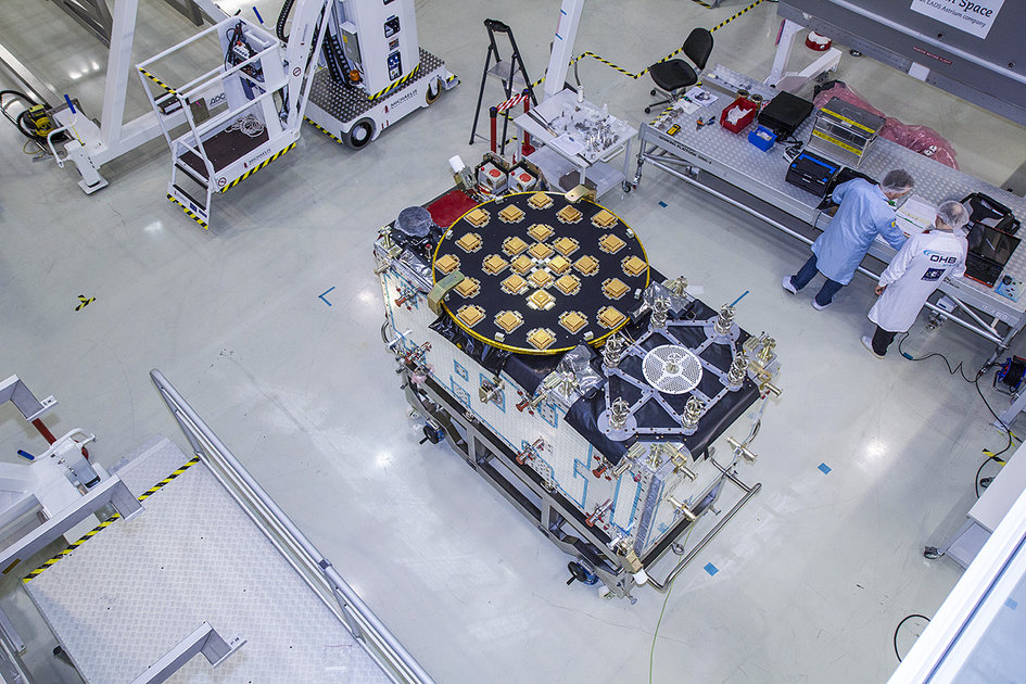
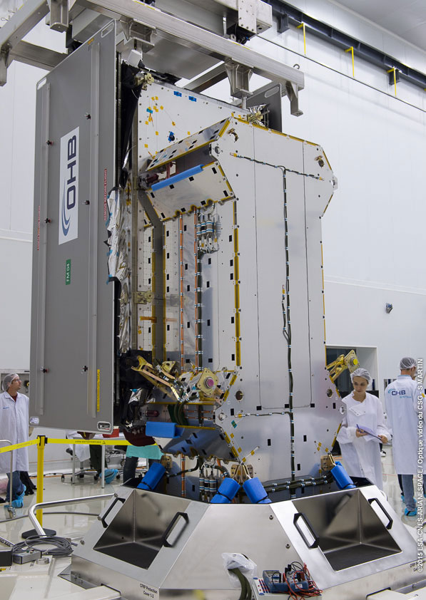
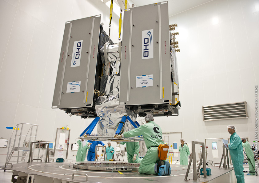
The Flight Model #3 (FM3) spacecraft is moved for positioning on the payload dispenser. (Photo credit: Arianspace)
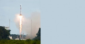
The third and fourth Galileo Full Operational Capability (FOC) satellites are a confirmed “fit” for their Arianespace Soyuz launch March 27, having made initial contact with the mission’s dual-payload dispenser in French Guiana, according to Arianespace.
The fit check was completed over a two-day period inside the Spaceport’s S1A payload preparation building. The two satellites were installed separately, with the Flight Model #3 (FM3) spacecraft integrated on — and subsequently removed from — the dispenser on Feb. 9. Flight Model #4 (FM4) underwent the same process the following day.
The payload dispenser for Galileo was developed by RUAG Space Sweden for Arianespace, and carries one satellite on each side. It will deploy the spacecraft during the Soyuz launch by firing a pyrotechnic separation system to release them in opposite directions at the orbital insertion point.
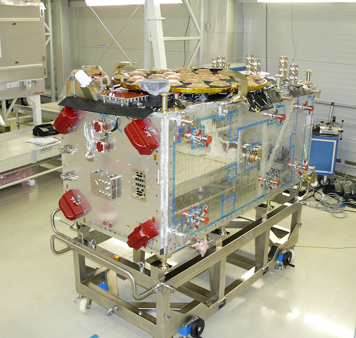
Flight Model #4 (FM4) after its integration. (Photo credit: Arianspace)
Final integration on the dispenser is to be performed during upcoming processing at the spaceport, and will be followed by the completed unit’s installation on Soyuz.
The March 27 mission — designated Flight VS11 in Arianespace’s numbering system — will be the company’s fourth launch carrying spacecraft for the Galileo constellation. FM3 and FM4 were built by OHB System, with Surrey Satellite Technology Ltd. supplying their navigation payloads.
The Galileo network’s complete operational and ground infrastructure will be deployed during the Full Operational Capability phase, which is managed and funded by the European Commission. The European Space Agency has been delegated as the design and procurement agent on the commission’s behalf.
Will Be Employable for Surveying, Precise Positioning, and Geodesy
By Peter Steigenberger and André Hauschild, German Aerospace Center (DLR) / German Space Operations Center
The first Full Operational Capability (FOC) Galileo satellite started transmitting L-band navigation signals on November 29, 2014. Based on data collected by a global network of GNSS tracking stations of the Cooperative Network for GNSS Observation (CONGO) and the Multi-GNSS Experiment (MGEX) of the International GNSS Service (IGS), we determined that an E1 signal with pseudorandom noise code (PRN) E18 was first tracked at the station LLAG (La Laguna, Tenerife, Canary Islands) at 06:08 UTC. A few moments later, the satellite’s transmissions were also tracked at other MGEX stations including the E5a, E5b, and E5 AltBOC signals. Based on the computed satellite visibility at various tracking stations, the satellite could be positively identified as GSAT0201, also known as Galileo FOC-FM1 or Galileo 5 with COSPAR ID 2014-050A and NORAD ID 40128.
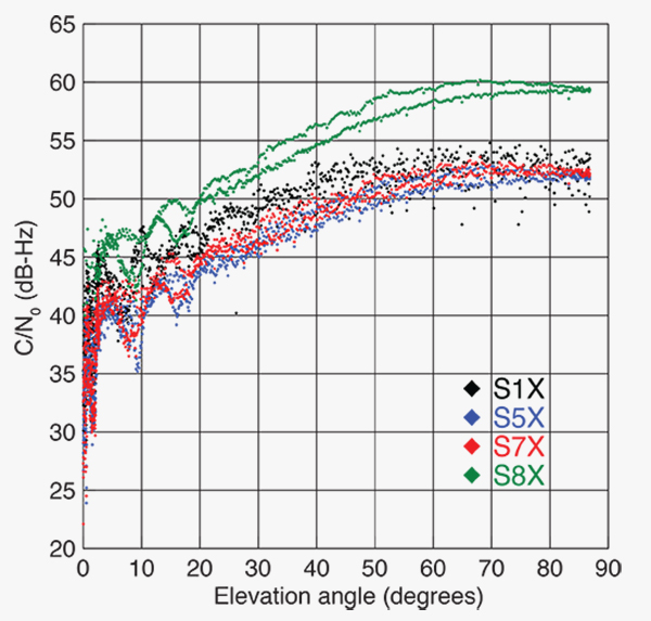
FIGURE 1 shows the carrier-to-noise-density ratio (C/N0) of the E18 signals tracked at the CONGO/MGEX station SIN1 (Singapore, using a Trimble NetR9 receiver with a Leica AR25.3 antenna). We selected the signals from this station for analysis due to an E18 pass occurring close to the zenith and covering almost the full range of elevation angles. The E5a and E5b signals (S5X and S7X RINEX identifiers) show very similar performance, whereas the C/N0 values of the E1 signal are 1–2 dB-Hz higher. The C/N0 values of the E5 AltBOC signal (S8X) reach 60 dB-Hz at high elevation angles, which is about 6 dB-Hz higher than the other signals.
Figure 1. Galileo E18 carrier-to-noise-density ratio for the CONGO/MGEX station SIN1 (Singapore).
The first pair of Galileo FOC spacecraft was launched on August 22 with a Soyuz launcher from the Guiana Space Centre, Kourou, French Guyana. Due to a malfunction of the Fregat upper stage, the satellites were injected into elliptical orbits with an inclination of about 49° instead of near circular orbits with 55° inclination. In November, the perigee of the first FOC satellite was raised by about 3,500 kilometers by a series of 11 maneuvers with a corresponding reduction in orbit eccentricity from 0.23 to 0.16.
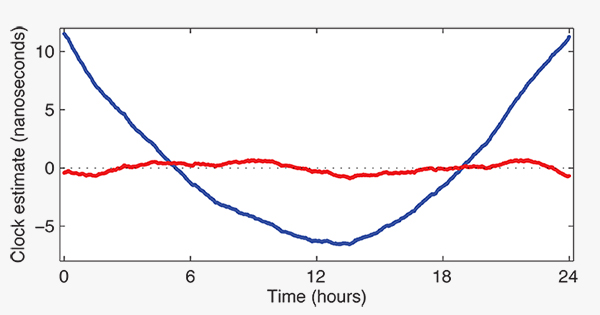
E18 has been included in the precise orbit and clock solutions of the MGEX analysis center at Technische Universität München (TUM) in Munich, Germany, since December 5. FIGURE 2 shows the detrended estimates of the active Galileo E18 clock for December 7. The presence of a pronounced quadratic term as well the large drift of 33.9 microseconds per day indicate that the active clock is a rubidium atomic frequency standard rather than a more precise passive hydrogen maser. The FOC satellites carry two of each kind of clock.
Figure 2. Galileo E18 clock estimates for December 7, 2014, with respect to the hydrogen maser at the Ottawa IGS station (NRC1) after removing an offset and drift (blue) or a second order polynomial (red).
The TUM orbit and clock product allows researchers to again compute dual-frequency positioning solutions using only Galileo observations, as the In-Orbit Validation satellite E20 has not transmitted an E5 signal since May, when a power anomaly left the satellite with the capability to only transmit an E1 signal. Furthermore, E20 currently does not transmit a navigation message.
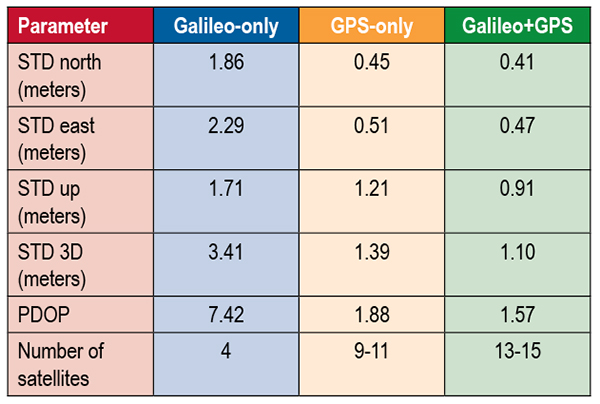
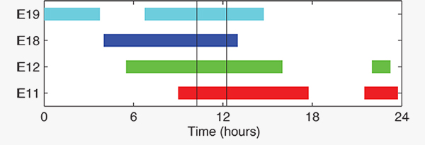
TABLE 1 shows the scatter of single-point positioning using pseudorange (code) observations from the MGEX station MAS1 (Maspalomas, Gran Canaria, Canary Islands) for a Galileo-only, a GPS-only, and a combined Galileo+GPS solution for December 6. At an elevation cut-off angle of 10°, four Galileo satellites were visible from 10:15 until 12:25 UTC (see FIGURE 3). The GPS-only solution covers the same time interval. The start time is not limited by the cut-off angle but an E18 transmission outage from 3:45–10:15 UTC.
TABLE 1. Single point positioning results for the MGEX station MAS1 (Maspalomas) for December 6, 2014.Figure 3. Galileo visibility at the MGEX station MAS1 (Maspalomas) on December 6, 2014. The time period considered in the single-point positioning is indicated by vertical lines.
We used an ionosphere-free linear combination of Galileo E1 and E5 AltBOC code observations and GPS L1 and L2 code observations with a 30-second sampling interval. As the Galileo-only solution suffered from position dilution of precision (PDOP) values of up to 830, a total of 32 epochs with PDOP values greater than 25 were excluded. The geometry of the remaining epochs is still pretty unfavorable. At a mean PDOP value of 7.4, the standalone position solution exhibits a 3D standard deviation (STD) error of 3.4 meters. Use of the Galileo satellites in a combined GPS+ Galileo solution improves the positioning performance. In particular, the height component benefits from the inclusion of the four Galileo satellites with a standard deviation improvement of 25 percent.
Despite the orbit injection error, the new Galileo FOC satellite has now been successfully activated and added to the Galileo constellation. Unfortunately, the current orbit is incompatible with the standard Galileo almanac format, which may cause restrictions for some commercial receiver types.
Nevertheless, the satellite can already be tracked by a wide range of geodetic receivers with existing firmware versions and it will, in fact, be possible to use the new satellite for diverse applications in surveying, precise positioning, and geodesy, as well as in general multi-GNSS studies. We now look forward to the activation of the second FOC satellite, which can be expected in early 2015 and will, for the first time, offer multi-frequency signals from a total of five Galileo satellites.
Sanctions Delay GLONASS-K2
According to Nikolai Testoyedov, the CEO of Information Satellite Systems Reshetnev, manufacturer of the GLONASS satellites, the company will now produce nine GLONASS-K1 satellites.
“For a smooth transition to a multi-functional group and due to issues with the very complex GLONASS-K2 satellites, we decided to continue with the GLONASS-K1 intermediate range of satellites, and we are preparing for the launch of nine units of this series,” he said.
He recalled the original plan was to launch two K1 satellites and then move to GLONASS-K2 satellites.
“In the beginning, really, we wanted after the two GLONASS-K1 satellites No. 11 and 12, to go for the launch of more advanced GLONASS-K2 devices. But, unfortunately, the plans had to be adjusted somewhat because of the sanctions restricting the delivery of radiation-resistant electronic components from the West. We have to put a hold on the in-depth development of technical and technological documentation and that delays us in terms of moving ahead by at least a year or two,”he said.
Reported by the Russian magazine Vestnik GLONASS, and relayed by Richard Langley’s CANSPACE listserv.
GNSS Mandates Would Violate Trade Agreements
A U.S. government representative stated at an international satnav forum that mandating use of specific GNSS services for applications such as air-traffic control, freight shipments, emergency calling, and road tolling could violate the terms of World Trade Organization (WTO) agreements that many nations, including all six GNSS providers, have signed.
Regional mandates already exist for GLONASS in Russia and BeiDou in China, and have been suggested and extensively discussed in Europe, as a way of stimulating the market adoption of Galileo receiver chipsets, thus recouping some of the massive public investment in the satnav system.
The presentation occurred during the Ninth Meeting of the International Committee on Global Navigation Satellite Systems (ICG), held Nov. 10–14, 2014, in Prague, Czech Republic.
Jason Kim, a senior policy analyst at the U.S. Department of Commerce, stated that the United States and the European Union already enjoy a productive dialog on GNSS trade issues under the 2004 U.S.-EU Agreement on GPS-Galileo Cooperation. In that agreement, both parties agreed to consult before establishing GNSS standards, certification requirements, regulations, mandates; affirmed their non-discriminatory approach with respect to GNSS trade; and established a working group to consider non-discrimination and other trade related issues.
Finally, the United States and the European Union recognized and reiterated in 2004 their commitments to WTO rules including those governing technical barriers to trade, specifically, that there would be no goods discrimination based on non-tariff measures such as regulations, standards, testing, or certification.
Kim made the remarks in the course of his presentation titled “GNSS Market Access.” He told GPS World that his presentation was directed less at the European Union, which has been conscientious of its WTO commitments, and more towards the rest of the ICG members, including non-provider nations that may be asked by GNSS providers to mandate specific systems.
“To promote adoption of their systems,” Kim stated, “GNSS providers are considering/implementing equipage mandates for various applications: aviation, motor-carrier and HAZMAT vehicle tracking, car accident reporting (eCall/ERA-GLONASS), and emergency phone calls (E112).
“The United States recommends technology-neutral, performance-based standards,” Kim continued, giving as example the U.S. E911 rules that specify a required positioning accuracy and then allow wireless carriers to choose the best technical solutions according to their lights.
The U.S. government presentation at ICG revealed particular concern that regulations under consideration could adversely affect the sales of U.S. GPS-enabled hardware in many industry sectors. All members of the WTO, including the six GNSS providers on the ICG, are bound to a range of trade agreements designed to promote open-market access, all cited in the Prague ICG presentation: the General Agreement on Tariffs and Trade (GATT), the Agreement on Technical Barriers to Trade (TBT), and the General Agreement on Trade in Services (GATS). The United States, Europe, Japan, and 12 others are also parties to the WTO Agreement on Government Procurement (GPA).
European Commission officials have publicly and recently stated that they are considering how to stimulate Galileo use, in particular through regulatory measures requiring that navigation equipment be installed on aircraft, automobiles, and other platforms.
“Requiring specific systems arbitrarily prevents or penalizes imports of goods having perfectly functional GNSS capability,” said Kim. “WTO members must comply with TBT obligations in setting technical regulations.”
He concluded his presentation by requesting that the ICG Providers’ Forum add GNSS market access to its future agenda for discussion, and consider developing a new principle on market access for future adoption.
Galileo IOV Bird Mute; New Draft ICD; CS Proved; Late August Launch
Orbiting in silence since an onboard power mishap on May 27, troubled E20 emitted cheeps from space on August 6, 7, and 8, broadcasting on the L1 frequency. Nothing has been heard since.
Meanwhile, the European Commission (EC) published a new draft version of the Galileo Open Service Signal in Space Interface Control Document (OS SIS ICD), issue 1, revision 2, on June 30. It is available for download and comment, the latter period extending to September 22. The EC’s open public consultation process seeks to ensure that any further development of the Galileo OS SIS ICD takes into account the views of key GNSS stakeholders. An online form for submitting comments is available.
Galileo E20, also known as GSAT0104, the fourth in-orbit validation (IOV) satellite, has been set “unavailable until further notice” according to the European GNSS Service Centre because of a sudden, unexpected loss of power on May 27.
Based on a selected set of IGS MGEX stations and all CONGO stations, the first signals were tracked at AREG, AUT0, LLAG, and UNB3 at 23:13:00. No E5 signals and no navigation messages are currently transmitted. Some JAVAD GNSS receivers report from time to time false E5a locks with zero or extremely small C/N0.
Galileo’s Early Proof of Concept (EPOC) team has successfully tracked the encrypted Galileo E6-B and E6-C signals broadcast by Galileo satellites. As a result, the Commercial Service loop has been closed using both encrypted and non-encrypted signals.
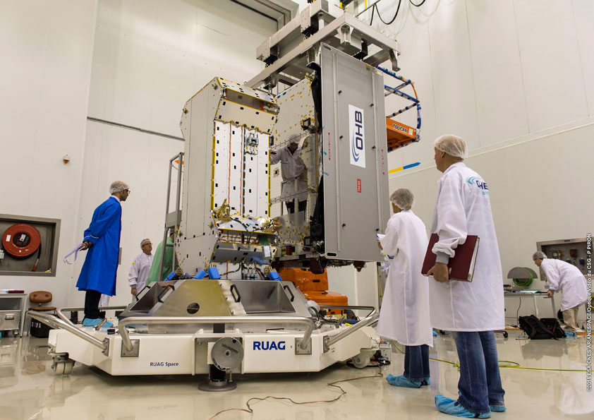
The completed dispenser unit is ready to be transferred from the S5 payload preparation facility for its integration atop Soyuz’ Fregat upper stage.
During a 10-day testing period, receivers in Tres Cantos, Spain and Poing, Germany, showed the successful tracking and data demodulation of the encrypted signals from the available Galileo satellites, with periods where all satellites transmitting E6 encrypted signals were tracked simultaneously. The tests verified the Galileo Commercial Service (CS) signal’s encryption functionalities, with the data received containing authentication and high accuracy information previously generated outside the Galileo system. This is an essential feature to ensuring Galileo’s high accuracy and authentication services.
The Galileo Commercial Service will deliver a range of added-value features, including positioning accurate to decimeter level and an authentication element. The Galileo CS demonstrator began its proof of concept earlier this year, with early service expected to start in 2016.
Once operational, the CS will provide access to two additional encrypted signals on the E6 band, delivering a higher data throughput rate and increased accuracy. The tests are the result of a collective effort involving teams and projects of AALECS (Authentication and Accurate Location Experimentation with the Commercial Service), supported by the European Commission, the GSA, the European Space Agency (ESA), and the Galileo operator Spaceopal.
The AALECS project is building a platform to connect to the European GNSS Service Centre (GSC) and transmit real-time CS data through the Galileo satellites. This platform will be operational by 2015 and will demonstrate the real performance of future high-accuracy and authentication services of Galileo prior to early service availability.
The European Commission launched AALECS in January 2014, and it was awarded to a consortium led by GMV including CGI, Qascom, IFEN, Veripos, and KU Leuven.
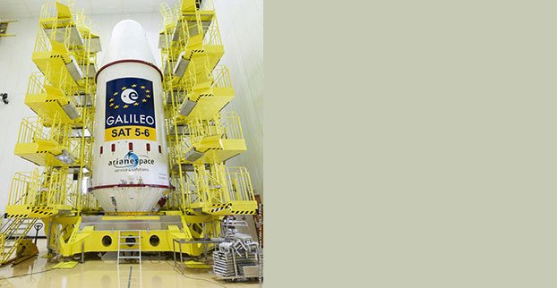
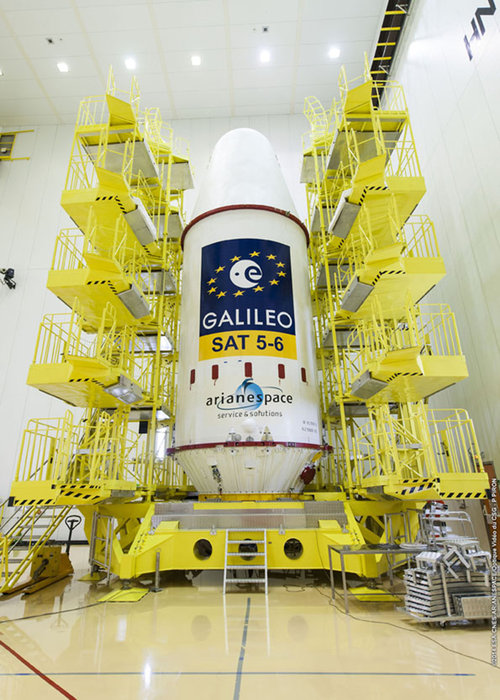
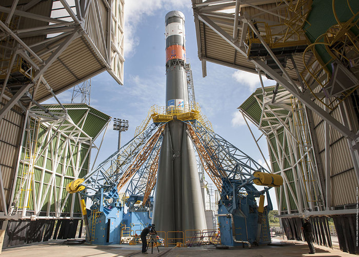
New Launch. At press time, the next Galileo satellites were set to launch on August 21, ushering in the system deployment phase and paving the way for the start of initial services. Galileo SATs 5 and 6 were scheduled to lift off from Europe’s Spaceport in French Guiana on top of a Soyuz rocket. They are expected to become operational, after initial in-orbit testing, in autumn.
The two satellites will join the four Galileo in-orbit validation satellites already in space. Launched in pairs in October 2011 and October 2012, these four — the minimum required to obtain a position fix — demonstrated and validated the system’s space and ground segments.
SATs 7 and 8 are scheduled to follow by end of year 2014. Then the constellation will be gradually deployed with six to eight satellites launched per year, along with addition of remaining elements of the ground network.
Adjacent-Band Compatibility Workshop Set for D.C.
The U.S. Department of Transportation is holding a “GPS Adjacent Band Compatibility Assessment Workshop” on September 18, 10 a.m.–5 p.m. Eastern Daylight Time. Registration for the workshop is required, and closes September 4. The general public can either attend in person or via WebEx.
The workshop is being held to discuss implementation of a GPS Adjacent Band Compatibility Assessment. Discussion will focus on the various implementation steps of the assessment, including development of GPS receiver use cases, identification of representative GPS receivers, and development of a test and analysis program. “In particular, emphasis will be placed on the information needed from GPS receiver and antenna manufacturers, and the logistics of procuring and handling that information to safeguard manufacturer proprietary data,” according to the Federal Register.
The sponsoring agency is the Office of the Assistant Secretary for Research and Technology, Department of Transportation.
The meeting will be held at the U.S. Department of Transportation, John A. Volpe National Transportation Systems Center, 55 Broadway, Cambridge, MA 02142. ID is required to enter the building. For details, see the Federal Register notice.
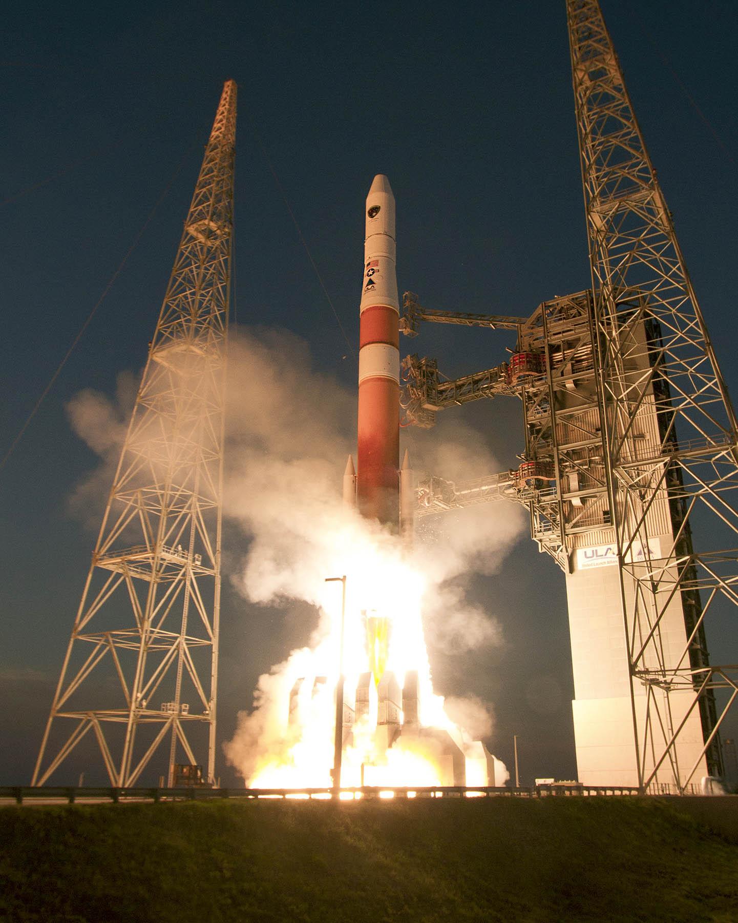
GPS IIF-7 Successfully Launched
Last USAF Launch to Rely on Radar as GPS Tracking Takes Over
A United Launch Alliance (ULA) Atlas V rocket carrying the seventh GPS IIF satellite for the U.S. Air Force launched at 11:23 p.m. EDT Friday, August 1 (03:23 UTC, August 2), from Space Launch Complex-41 at Cape Canaveral, Florida.The Boeing-built satellite has sent the signals to controllers that confirm it is currently operating properly within the constellation.
Boeing and the Air Force will complete the full on-orbit checkout of the satellite in August. The GPS IIFs offer improved signal accuracy, better anti-jamming capability, longer design life and the new civilian L5 signal.
“We are providing our Air Force partner and GPS users with a steady supply of advanced GPS IIFs,” said Craig Cooning, president of Boeing Network & Space Systems. “Our robust launch tempo requires vigilance and attention to detail, and mission success is our top priority. We continue to partner with the Air Force and ULA to effectively execute the launch schedule.”
GPS IIF-7 is the seventh of 12 such satellites Boeing has built for the U.S. Air Force, and the third on-orbit delivery this year. GPS IIF-8, slated for launch during the fourth quarter, arrived at Cape Canaveral on July 16 to undergo final launch preparations. GPS IIF-7 will join a worldwide timing and navigation system utilizing 24 satellites in six different planes, with a minimum of four satellites per plane positioned in orbit approximately 11,000 miles above the Earth’s surface.
“Congratulations to the U.S. Air Force and all of our mission partners on the successful launch of the Atlas V carrying the GPS IIF-7 satellite,” said Jim Sponnick, ULA vice president, Atlas and Delta Programs. “ULA launch vehicles have delivered all of the current generation of GPS satellites, which are providing ever-improving capabilities for users around the world.”
This mission was launched aboard an Atlas V Evolved Expendable Launch Vehicle (EELV) 401 configuration vehicle, which includes a 4-meter-diameter payload fairing. The Atlas booster for this mission was powered by the RD AMROSS RD-180 engine, and the Centaur upper stage was powered by a single Aerojet Rocketdyne RL10A engine.
The EELV program was established by the United States Air Force to provide assured access to space for Department of Defense and other government payloads. The commercially developed EELV program supports the full range of government mission requirements, while delivering on schedule and providing significant cost savings over the heritage launch systems.
C-Band Radar. The launch August 1 marked the final time the Air Force is expected to rely on C-band radars to track rockets immediately following liftoff.
Future Air Force launches, both from the Cape and from Vandenberg Air Force Base in California, will rely on GPS signals for post-liftoff tracking, service officials said. The Air Force and its primary launch services provider, ULA, have been working for years on the capability, which features rocket-mounted GPS receivers that transmit position-location data to controllers on the ground.
“It’s something that’s been a long time coming,” Walt Lauderdale, GPS IIF-7 mission director, said during a July 25 conference call with reporters. The new technique has been tested and proven at both at Cape Canaveral and Vandenberg over the last few years, he said.
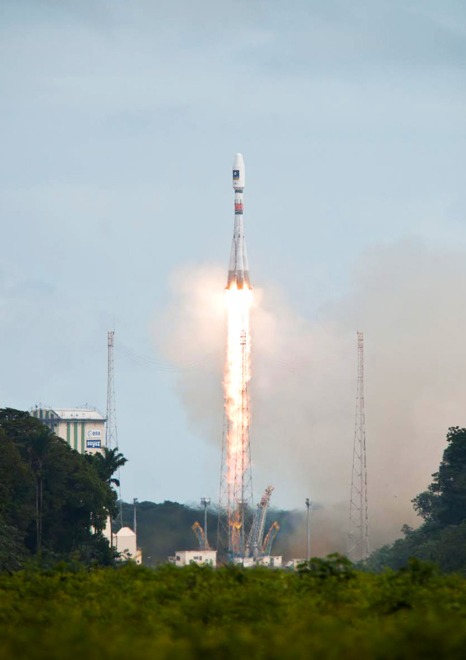
“Following the failure on Friday August 22nd to inject Galileo satellites 5 and 6 into the correct orbit, the European Commission has requested Arianespace and the European Space Agency (ESA) to provide full details of the incident, together with a schedule and an action plan to rectify the problem.”
This is the only official face showing, but extremely high levels of activity take place behind the curtain, studying what might have caused several million Euros of hardware to end up much lower above the Earth than desired. Meanwhile, active speculation in the satnav blogosphere provides glimpses of possible outcomes from the latest satellite disaster — not exclusive to Galileo, by any means — created in all likelihood by a malfunction aboard its Soyuz launcher and/or the Fregat upper stage thereof.
The full official EC announcement is available here.
The satellites are under the control of the European Space Operations Centre (ESOC), ESA’s main mission control center in Darmstadt, Germany. But they are far out off position — more than 3,500 kilometers of space away, so far as to make their eventual use as part of the Galileo constellation very unlikely. Discussions continue with ESA and Arianespace regarding whether or not the satellites are likely to be of use, but odds are against it.
Their onboard fuel is not enough to compensate for the launch shortfall to reach higher orbits under their own power. ESA scientists are studying how they might still possibly be used, far from their optimum position,s within the Galileo constellation.
According to an Arianespace press release on August 23, the target orbit was circular, inclined at 55 degrees with a semi-major axis of 29,900 kilometers, but what they got was an elliptical orbit, eccentricity of 0.23, semi-major axis of 26,200 kilometers and inclined at 49.8 degrees.
On August 28, the Russian newspaper Izvestia reported that “The failure of the European Union’s Galileo satellites to reach their intended orbital position was likely caused by software errors in the Fregat-MT rocket’s upper-stage.”
“The nonstandard operation of the integrated management system was likely caused by an error in the embedded software. As a result, the upper stage received an incorrect flight assignment, and, operating in full accordance with the embedded software, it has delivered the units to the wrong destination,” an unnamed source from Russian space Agency Roscosmos was quoted as saying by the newspaper.
An independent inquiry panel has been set up by Ariane. It is headed by former ESA Inspector General Peter Dubock. It starts work on August 28. The panel includes a couple of academics and a majority of ESA and EC figures.
Ferdinando Nelli Feroci, the new EC Commissioner for Industry and Entrepreneurship.
The new EC commissioner in this area, Ferdinando Nelli Feroci has invited ESA and Arianespace to his study during the first week of September to present the initial results of the inquiry.
The commissioner commented, “The problem with the launch of the two Galileo satellites is very unfortunate. The European Commission will participate in an inquiry with ESA to understand the causes of the incident and to verify the extent to which the two satellites could be used for the Galileo programme. I remain convinced of the strategic importance of Galileo and I am confident that the deployment of the constellation of satellites will continue as planned.”
The commissioner expects that the Galileo constellation will be fully deployed by the end of this decade. This may qualify as optimism because system planners had envisioned for six spares – and three are already blown.
Ariane and ESA did not insure the satellites.
According to back-of-the-envelope calculations, system operators are now one short of the minimum 24 needed for full 24/7 global coverage, as they have 4 IOVs up (1 broken) and 22 FOCs on order (2 launched and now in what could be called a junk orbit) which makes a potential maximum 23 sats that have actually been ordered – one short of the target.
The Satellites Are Alright
Satellite manufacturer OHB Systems of Bremen, Germany, issued a release stating that “Controllers at ESA’s ESOC control centre in Darmstadt, Germany, confirm the good health and the nominal behaviour of both satellites. They are in a safe configuration, are thermally stable, have stable pointing to the sun and sufficient power production. All platform subsystems have been checked and they work properly. Also the procedures to deploy the solar arrays are successfully performed and all solar arrays are properly unfolded.”
Further, “The orbit anomaly has no impact on the production and delivery of the in total further 20 satellites. Two FOC*-satellites are currently at ESTEC test facilities in Noordwijk, the remaining are in various status of integration. ”
Blogging the Boondoggle
The chairman of the Executive Board of the German Aerospace Center, Johann-Dietrich ‘Jan’ Wörner, writes an interesting blog. The current installment opens with a quote from Elon Musk: “Rockets are tricky.”
Wörner goes on to say, “The Soyuz launcher lifted off from the European Spaceport in French Guiana. Initially, all of the measurements suggested a perfect mission; the launcher took off at the scheduled time, followed the prescribed trajectory, and the stage separation was carried out correctly. However, the first problem became apparent when the two satellites proved unable to deploy their solar arrays as intended. A more detailed analysis then revealed that the eccentricity, the altitude and the inclination of the satellites’ orbits with respect to Earth’s equator did not meet the specifications. The upper stage had also evidently failed to induce the planned rotation around the longitudinal axis of the spacecraft (known as ‘barbeque’ mode, designed to maintain favourable thermal conditions during exposure to the Sun).”
Further discussion of the possible causes of the anomaly can be found on a Russian site, which focuses on the Fregat stage thrusters and indicates that the Russians think the barbeque maneuver was completed, and thus not the problem.
The other big issue is how the telemetry didn’t pick up the issue straight away.
There is avid speculation and a number of interesting theories being aired on the Canadian Space Geodesy Forum. For subscriptions to this vital listserv, visit here.
Following the major anomaly that occurred on August 22 during the Soyuz ST mission carrying two satellites in the Galileo constellation, Arianespace announced today, in conjunction with the European Space Agency (ESA) and the European Commission, the appointment of an independent inquiry commission.
The commission is chaired by Peter Dubock, former ESA Inspector General. Its mandate is to establish the circumstances of the anomaly, to identify the root causes and associated aggravating factors, and make recommendations to correct the identified defect and to allow for a safe return to flight for all Soyuz launches from the Guiana Space Center (CSG).
The commission will start its work on August 28 and submit its initial conclusions as early as September 8.
The inquiry commission comprises the following members:
Peter Dubock, former ESA Inspector General, Chairman;
Professor Guido Colasurdo, University of Roma “Sapienza”, full professor of flight mechanics;
Michel Courtois, former ESA Technical Director;
Paul Flament, European Commission, Head of Unit, Galileo and Egnos Programmes Management, DG for Entreprise and Industry;
Giuliano Gatti, ESA, Galileo Program Technical Officer;
Professor Wolfgang Kubbat, former head of the Institute of Flight Systems and Automatic Control at the Technical University of Darmstadt;
Isabelle Rongier, CNES Inspector General;
Toni Tolker Nielsen, ESA Deputy Inspector General.
To maintain links with the Russian partners in the Soyuz at CSG program, the head of the Russian space agency Roscosmos, on request from the head of Arianespace, has designated Alexander Daniliuk, Deputy Director General of TsNIImash, as board liaison.
Arianespace Chairman and CEO Stéphane Israël said: “I would like to thank Peter Dubock for having accepted the chairmanship of this commission, which was appointed in conjunction with ESA and the European Commission and with the support of the space agencies from France (CNES), Germany (DLR) and Italy (ASI), along with a team of high-level European experts. The commission will now be able to carry out its work independently, operating under a very tight schedule. We sincerely hope that the commission’s recommendations will lead to a rapid resumption of missions, while ensuring the high reliability expected of our Soyuz launches from CSG.”
After the separation of the two Galileo satellites launched August 22, ongoing analysis of the data provided by the telemetry stations operated by the European Space Agency (ESA) and the French space agency CNES showed that the satellites were not in the expected orbit.
According to the initial analyses, an anomaly is thought to have occurred during the flight phase involving the Fregat upper stage, causing the satellites to be injected into a noncompliant orbit.
The liftoff and first part of the mission proceeded nominally, reports Arianespace, leading to release of the satellites according to the planned timetable, and reception of signals from the satellites. However, the targeted orbit was circular, inclined at 55 degrees with a semi major axis of 29,900 kilometers. The satellites are now in an elliptical orbit, with excentricity of 0.23, a semi major axis of 26,200 km and inclined at 49.8 degrees.
Both the Fregat upper stage and the two satellites are in a stable condition and position that entails no risk for people on the ground. The residual propellants on the Fregat stage have been purged and the stage was depressurized normally.
Studies and data analyses are continuing in Kourou, French Guiana, and at Arianespace headquarters in Evry, near Paris, under the direction of Stéphane Israël, Chairman and CEO of Arianespace, in conjunction with the Russian partners in the Soyuz in French Guiana program (Russian space agency Roscomos and the manufacturers RKTs-Progress and NPO Lavotchkine), as well as Arianespace’s customer ESA and its industrial partners, to determine the scope of the anomaly and its impact on the mission.
Following the announcement made by Arianespace on the anomalies of the orbit injection of the Galileo satellites, ESA said that the teams of industries and agencies involved in the early operations of the satellites are investigating the potential implications on the mission.
Both satellites have been acquired and are safely controlled and operated from ESOC, ESA’s Operations Centre in Darmstadt, Germany. Further information on the status of the satellites will be made available after the preliminary analysis of the situation.
“Our aim is of course to fully understand this anomaly,” said Stéphane Israël, Chairman and CEO of Arianespace. “Everybody at Arianespace is totally focused on meeting this objective. Starting Monday, Arianespace, in association with ESA and the European Commission, will designate an independent inquiry board to determine the exact causes of this anomaly and to draw conclusions and develop corrective actions that will allow us to resume launches of Soyuz from the Guiana Space Center (CSG) in complete safety and as quickly as possible. The board will coordinate its work with Russian partners in the Soyuz at CSG program. Arianespace is determined to help meet the European Union’s goals for the Galileo program without undue delay. We would like to thank ESA, the European Commission and CNES for the very productive discussions since becoming aware of the occurrence of the anomaly. While it is too early to determine the exact causes, we would like to offer our sincere excuses to ESA and the European Commission for this orbital injection that did not meet expectations.”
New NORAD element sets from Sunday confirm that the satellites and the Fregat upper stage are in the wrong orbits:
A sixth GPS IIF satellite was launched aboard a United Launch Alliance Delta 4 rocket from Cape Canaveral at 8:08 p.m. EDT May 16.
The satellite, designated GPS IIF-6 and built by Boeing, is one of the next-generation GPS satellites, incorporating improvements to provide greater accuracy, increased signals, and enhanced performance for users.
According to Boeing, each GPS IIF satellite has greater navigational accuracy through improvements in atomic clock technology and a new civilian L5 signal to aid commercial aviation and search and rescue operations.
Interestingly, the rocket is the first to be tracked via GPS instead of by radar.
United Launch Alliance’s Atlas and Delta rockets are transitioning to GPS metric tracking for range safety functions, which protect the public and property should a launch vehicle veer off course. The move is a money-saving upgrade to the military’s aging range infrastructure.
A special avionics system on the launcher transmitted the location. For decades, most rockets launching from Cape Canaveral, Florida, and Vandenberg Air Force Base, California, have been tracked by C-band radar.
Two more GPS IIF satellites are scheduled to launch before the end of the year.
Galileo FOC Satellites Reach Spaceport
Galileo’s first two full operational capability (FOC) satellites arrived in Kourou, French Guiana, on May 7, in preparation for launch this summer.
Manufactured by OHB in Bremen, Germany, with navigation payloads contributed by Surrey Satellite Technology Ltd. in Guildford, UK, these satellites — the first of 22 full-capability models — had spent several months at ESA’s Technical Centre, ESTEC, in Noordwijk, the Netherlands, where they underwent exhaustive testing in simulated space conditions.
The Galileo satellites are named for the children who won a painting competition organized by the European Commission in 2011. Doresa and Milena, the first two FOC satellites, will be launched together aboard a Soyuz rocket, joining the four Galileos already in orbit. Adam, the third Galileo FOC satellite, is now undergoing testing under space conditions at ESTEC. Anastacia, the fourth Galileo FOC satellite, will begin final testing at OHB in Bremen before being shipped to ESTEC.
“A steady stream of satellites is foreseen, coming from OHB to ESTEC for acceptance testing and then on to French Guiana,” said an ESA official.
Arianespace is already facing an exceptionally crowded launch manifest in 2014. A well-informed source opined, “If one were to hazard a guess, here is the most likely scenario: O3b arrives ready for launch several weeks ahead of Galileo and secures the June launch. Galileo moves to August and is promised a second launch in the autumn. O3b’s planned second launch in 2014 is moved to early 2015, as is the planned third launch of Galileo.
“The effect of these schedule slips on the cost of the Galileo program, which is about a year late — cost overruns that Tajani has vowed will not be paid by the commission — is a subject for another day.”
New Loran at 5 Meters
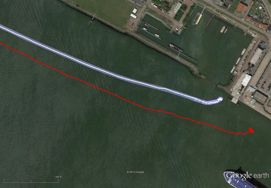
The red track is based on raw eLoran data without any corrections. The transparent blue line is made by GPS-RTK and is widened to 10 meters, giving the required ± 5-meter limits of eDLoran. The white line is output from the eDLoran receiver, which stays within the borders of the 10-meter-wide transparent blue line.
Dutch consultants Reelektronika showed results from a prototype enhanced differential Loran (eDLoran) system, extensively tested in the Europort (Rotterdam) area, at the European Navigation Conference held in April. The tests achieved accuracies of 5 meters. A full technical article describing the equipment, methodology, and test results will appear in the July issue of GPS World.
Harbor pilots require accuracies of 5 meters and some form of robustness or back-up for GNSS systems in case of jamming, unintentional interference, system failure, or other disruption.
The current eLoran system cannot get better than 10-meter accuracy. The new eDLoran opens up new possibilities for multiple applications:
Installing eDLoran reference stations is fast, simple, and cost effective.
As there is no data channel bandwidth limitation, multiple reference stations can be installed, which offers increased reliability and makes the system more robust against terrorism and lightning damage.
A single or multiple eDLoran servers can be installed in a protected area. There is hardly a practical limit in the number of differential reference stations to serve.
CNAV on L2C and L5 Initiated
On April 28, U.S. Air Force Space Command began broadcasting civil navigation (CNAV) messages on all operational GPS satellites capable of transmitting the L2C and L5 signals. L2C is designed for commercial needs and L5 meets safety-of-life transportation requirements.
“These new CNAV messages will enable manufacturers to develop and test advanced civil receivers and make for a more robust position, navigation, and timing (PNT) solution available to the civilian public,” said Maj. Gen. Robert E. Wheeler. “We do not anticipate any GPS satellite outages or legacy degradations as a result of the pre-operational deployment of these frequencies, and those currently using the GPS Standard Positioning Service should not be impacted.”
Initial CNAV broadcast occurs at a reduced data accuracy and update frequency compared to GPS signals in use today. In December 2014, CNAV data updates will increase to a daily rate, bringing L2C and L5 signal-in-space accuracy on par with legacy signals. However, derived position accuracy cannot be guaranteed during the pre-operational deployment. These signals are primarily used to test various equipment and should be employed at the users’ own risk; not used for safety-of-life or other critical purposes.
The Air Force will broadcast L2C messages with the health bit set “healthy,” as was the case during a June 2013 test. L5 messages will be set “unhealthy,” but as experience grows with L5 broadcast and implementation of signal monitoring is achieved, this status may change upon review.
Artist’s concept of a GPS III satellite in orbit, courtesy of Lockheed Martin.
Air Force Orders GPS III Satellites 05 and 06 from Lockheed Martin
A December 12 contract modification provided Air Force funding to Lockheed Martin to complete the fifth and sixth GPS III space vehicles (SV 05-06). Lockheeed originally received funding to procure long-lead parts for satellites five through eight (SV 05-08) in February 2013.
The $200,700,415 cost-plus-incentive-fee modification (P00276) on an existing contract (FA8807-08-C-0010) for GPS III space vehicles 05 and 06 means that work will be performed at Littleton. Colorado and Clifton, New Jersey, and is expected to be completed by Dec. 14, 2017 for space vehicle 05 and June 14, 2018 for space vehicle 06. The Air Force Space and Missile Systems Center Contracting Directorate, Los Angeles Air Force Base, California, is the contracting activity.
Galileo Achieves First Airborne Tracking
The European Space Agency’s Galileo satellites have achieved their first aerial fix of longitude, latitude, and altitude, enabling the inflight tracking of a test aircraft.
ESA’s four Galileo satellites in orbit have supported months of positioning tests on the ground across Europe since the first fix in March. Now the first aerial tracking using Galileo has taken place, determining the position of an aircraft using only its own independent navigation system.
The milestone took place on a Fairchild Metro-II above Gilze-Rijen Air Force Base in the Netherlands on November 12. It was part of an aerial campaign overseen jointly by ESA and the National Aerospace Laboratory of the Netherlands, NLR, with the support of Eurocontrol, the European Organisation for the Safety of Air Navigation, and LVNL, the Dutch Air Navigation Service Provider.
A pair of Galileo test receivers was used aboard the aircraft, the same kind employed for Galileo testing in the field and in labs across Europe. They were connected to an aeronautical-certified triple-frequency Galileo-ready antenna mounted on top of the aircraft.
Tests were scheduled during periods when all four Galileo satellites were visible in the sky. The receivers fixed the plane’s position, as well as determining key variables such as the position, velocity, and timing accuracy; time to first fix; signal-to-noise ratio; range error; and range–rate error.
Testing covered both Galileo’s publicly available Open Service and the more precise, encrypted Public Regulated Service, whose availability is limited to governmental entities.
Flights covered all major phases: take off, straight and level flight with constant speed, orbit, straight and level flight with alternating speeds, turns with a maximum bank angle of 60 degrees, pull-ups and push-overs, approaches and landings.
The flights also allowed positioning to be carried out during a wide variety of conditions, such as vibrations, speeds up to 456 km/h, accelerations up to 2 ghorizontal and 0.5–1.5 gvertical, and rapid jerks. The maximum altitude reached during the flights was 3,000 meters.
GPS III Prototype Proves Constellation Compatibility
The Lockheed Martin prototype of the next-generation GPS satellite, the GPS III, has proven that it is backwardly compatible with the existing GPS satellite constellation in orbit.
During tests concluded on October 17, Lockheed Martin’s GPS III testbed successfully communicated via cross-links to Air Force simulators of the current GPS constellation in orbit. The current GPS constellation includes GPS IIR, GPS IIR-M, and GPS IIF satellites.
Testing also demonstrated the ability of an Air Force receiver to track navigation signals transmitted by the GPS III Nonflight Satellite Testbed (GNST). The GNST is a full-sized, functional satellite prototype at Cape Canaveral Air Force Station.
“These tests represent the first time when the GNST’s flight-like hardware has communicated with flight-like hardware from the rest of the GPS constellation and with a navigation receiver,” explained Paul Miller, Lockheed Martin’s director for GPS III Development. “This provides early confidence in the GPS III’s design to bring advanced capabilities to our nation, while also being backward-compatible.”
The first flight-ready GPS III satellite is expected to arrive at Cape Canaveral in 2014, for launch by the Air Force in 2015.
GPS III satellites will be the first GPS space vehicles with a new L1C civil signal designed to make it interoperable with other international global navigation satellite systems.
The GNST has helped to identify and resolve development issues prior to integration and test of the first GPS III flight space vehicle (SV 01). It has gone through the development, test, and production process for the GPS III program first, significantly reducing risk for the flight vehicles, improving production predictability, increasing mission assurance, and lowering overall program costs.
The GPS III team is led by the Global Positioning Systems Directorate at the U.S. Air Force Space and Missile Systems Center.
Lockheed Martin is the GPS III prime contractor, with teammates including ITT Exelis, General Dynamics, Infinity Systems Engineering, Honeywell, ATK, and other subcontractors.
Good News for Users and Manufacturers
The U.S. Air Force is directing transmission of continuous CNAV message-populated L2C and L5 signals starting in April 2014. The move is designed to help development of user equipment compatible with the civil signals. Full text of the CNAV memo appears below.
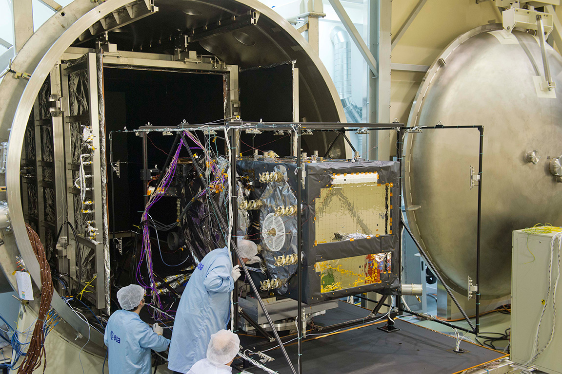
Galileo FOC Satellites Endure Simulated Space Tests
The European Space Agency’s newest Galileo satellite has emerged from five weeks of simulated space conditions. On November 29, a hatch slid open to end its thermal-vacuum test, a milestone on the way to orbit.
The satellite was placed in the 4.5-meter-diameter Phenix chamber in ESA’s ESTEC Test Centre in Noordwijk, the Netherlands, in late October. Once inside, the air was pumped out to create a space-quality vacuum. Temperature extremes were also reproduced, with the six copper walls of the thermal tent cooled by liquid nitrogen down to –180°C.
A second Galileo vehicle has been undergoing the same rigors at the site, along with a vibration and shock test to reproduce separation from the launcher. Thermal-vacuum testing on the second model will begin in early 2014. The two satellites will be launched on a Soyuz rocket from Europe’s Spaceport in French Guiana in mid-2014.
The next satellite is expected to arrive at ESTEC in March, with further satellites following every seven weeks or so. A total of 22 FOC satellites are being built by OHB in Germany, with navigation payloads being delivered from Surrey Satellite Technology Ltd. in the UK.
The first Galileo Full Operational Capability satellite emerges from the Phenix test chamber after five weeks of thermal–vacuum testing.
Recently released views of the next two Galileo satellites in the European Space Agency’s testing lab, along with dual-launch rumblings from the U.S. Air Force and Lockheed Martin, occasion this story about two birds with one drone. That is, an unmanned autonomous vehicle bound for the exosphere. The rest of the GNSS world is on board with this topic; isn’t it about time GPS caught up?
The first two Galileo Full Operational Capability (FOC) satellites will launch as a pair, earlier advertised as a September blast, now possibly delayed until December; a second dynamic duo will follow sometime thereafter. Then two again, and two, and two, until the Ariane 5 rocket launches four at once. Four!
The latest official U.S. Air Force plans say that by the ninth GPS III satellite (SV-09), the program plans to initiate programmatic and hardware changes to allow for the first-ever GPS dual launch. The motive, of course, is cost savings. The GPS program (probably) has no need to hurry, as other GNSSes do, in order to have a full constellation operative broadcasting — previous predictions about constellation gaps notwithstanding.
Even with dual launch, according to Lockheed Martin Navigation Systems vice president Keoki Jackson (and here I am drawing from Don Jewell’s Space Symposium column), from SV-09 forward the savings will only amount to about $70 million per launch, because it will require a larger launch vehicle.
Only $70 million. Well, to quote Senator Everett Dirksen, adjusting for inflation, “$70 million here, $70 million there, pretty soon, you’re talking real money.”
Take this all in the context of GPS III having reached the point that it will cost nearly $450 million to place a single GPS space vehicle and payload in orbit.
Rising costs and the possibility to combat them with dual launches constitute at least one of the driving forces behind the NavSat or NibbleSat drawing-board concept: a small GPS satellite, without the burden of other non-nav payloads.
Coincidentally, an initiative underway seeks to evaluate “new launch entrants,” according to General Willie Shelton, commander, Air Force Space Command. “If a new entrant can come in and provide a cost-effective launch capability for several launches, then we will look seriously at them as well,” he told Don Jewell in an interview nearly a year ago.
Jewell: “Why don’t we move into the arena of trying to pin down a vehicle or set of vehicles for dual launch? You and I once discussed GPS III vehicles 7-8 for that honor, and you mentioned at the time that it was a moving target. Where do we stand today?
General Shelton: Don, I think we are now probably talking about GPS III vehicles 9-10. We are still in the study phase on this issue with Lockheed Martin and United Launch Alliance. We are still trying to figure out how we would do dual launch and what kind of capabilities we need to develop. I think this is really the wave of the future…being able to put two up simultaneously will save us a lot in launch costs.”
In April of this year, John Frye, Lockheed Martin’s GPS III capability and affordability insertion manager, reiterated, in comments regarding the Delta Preliminary Design Review (dPDR) for the GPS III satellite, “The design modifications from this dPDR address ways to further reduce Air Force launch costs by $50 million per satellite through dual launch of two GPS III space vehicles on a single booster. This successful dPDR milestone sets the stage to proceed with SV09 design maturation.”
Rockets. Recently, the U.S. Air Force Space and Missile Systems Center (SMC) signed a Cooperative Research and Development Agreement (CRADA) with Space Exploration Technologies Corp., better known as SpaceX, as part of the company’s effort to certify its Falcon 9 v1.1 launch system for National Security Space (NSS) missions.
SMC and SpaceX will look at the Falcon’s flight history, vehicle design, reliability, safety systems, and other aspects. Once the evaluation is complete, the SMC commander will determine whether SpaceX has the capability to successfully launch NSS missions using the Falcon 9 v1.1.
Currently, United Launch Alliance’s Delta IV and Atlas V are the only certified launch vehicles capable of lifting NSS payloads — such as the GPS satellites — into orbit.
The Falcon CRADA may be a preliminary, tentative move towards dual-launch capability. Consider:
An earlier iteration, Falcon 9, can reportedly lift payloads of 4,850 kilograms (10,700 lb) to geostationary transfer orbit (GTO). The Falcon 9 v1.1— subject of the CRADA and scheduled for first flight in mid-2013—will use a longer first stage powered by nine Merlin 1D engines arranged in an octagonal pattern. Development testing of the v1.1 Falcon 9 first stage was just completed in June. These improvements will increase the payload capability by nearly 50 percent. The new first stage can also be used as side boosters on Falcon Heavy, which reportedly will have a capability of lifting 12,000 kg (26,000 lb) to GTO.
According to an Air Force fact sheet, the GPS III satellite has a launch weight of 8,115 lb.
The Atlas V 401 rocket, most recently used to launch the GPS IIF-4 satellite in May, has a GTO launch capability of 4,750 kg. (10,472 lb.) A steroid version of the Delta IV, the Delta IV Heavy, has a GTO launch capability of 13,130 kg (28,950 lb), more than any other currently available launch vehicle. It also carries a more substantial price tag.
To sum up these various vectors pointing largely in the same direction, GPS has a potential in the somewhat near-mid distant future of going to dual launch.
Meanwhile, this has been fait accompli for the other GNSSes.
Galileo
The first two in-orbit validation (IOV) satellites built by Astrium traveled aloft together in October 2011, as did the third and fourth IOV satellites in October 2012.
According Paul Flament, European Commission Programme Manager and Head of the EU Satellite Navigation Programme Unit, in an interview earlier this year with GPS World, “Satellites 5 and 6 will be launched in September of this year, aboard a Soyuz launcher from Kourou, and numbers 7 and 8 will follow in December.” These launches may since have been re-adjusted to later dates, respectively.
“Then, in 2013 we will see three Soyuz launches of two satellites each. We do not have the precise launch dates yet, but they are likely to be in April, June, and September. In December 2014, we expect to have the first launch using the Ariane 5 launcher, which is capable of deploying four satellites in one go. This means that by the end of 2014 Galileo will have deployed 18 satellites in orbit.
“In 2015, there will be two Ariane 5 launches, one in the middle of the year, one at the end, each carrying four satellites.”
GLONASS
Within days, perhaps, three GLONASS-M satellites will blast off together from Baikonur: GLONASS 48, 49, 50. This is only the latest of GLONASS triple launches.
As Richard Langley is my witness, the Russians accomplished a GLONASS hat-trick as long ago as September 1986! The first in a more recent series of triplets, in December 2010, failed rather spectacularly and cost Russia an estimate 5 billion roubles ($160 million), setting back GLONASS by six months. The system has since intermingled single- and triple-satellite launches.
Compass
China has demonstrated success with two dual launches of mid-Earth orbit satellites, among its constellation lodged at varied heights. Compass-M3 and Compass-M4 rose together in April 2012, as did M5 and M6 in September of that year.
In the early hours of May 15, Galileo’s first full operational capability (FOC) satellite left the manufacturer’s integration hall in Bremen, Germany. The satellite, assembled by OHB System AG, is now headed for Noordwijk in the Netherlands, where it will undergo an environmental testing campaign and further system testing at the ESTEC’s Test Center on the premises of the European Space Agency (ESA).
Before the satellite was shipped, it had successfully completed integration and system testing, according to OHB System.
The first Galileo FOC satellite. (Photo credit: OHB System AG.)
Its twin FOC satellite is in the final phase of completion at OHB System. Over the next few weeks, it will also be integrated and tested, after which it will be shipped to Noordwijk. The two satellites are to be placed in orbit on board a Soyuz launcher, which will is planned to lift off from Kourou in French Guyana this fall.
These two satellites are the first of a series of 22 Galileo FOC satellites manufactured by OHB System and its industrial partners. The FOC phase of the Galileo program is managed and funded by the European Union. The European Commission and ESA have signed a delegation agreement by which ESA acts as design and procurement agent on behalf of the commission.
At ESA’s test center, thermal vacuum testing will simulate the temperature extremes the satellites must endure in the airlessness of space throughout their 12-year working lifetimes. Without any moderating atmosphere, temperatures can shift hundreds of degrees from sunlight to shadow.
Other activities on the schedule include shaker and acoustic noise testing — simulating the vibration and noise of launch — as well as electromagnetic compatibility and antenna testing, placing the satellite in chambers shielded from all external radio signals to reproduce infinite space and check that its various antennas and electrical systems are interoperable without harmful interference.
Each satellite will offer the full range of Galileo positioning, navigation and timing services, plus search and rescue message relays, their accuracy ensured by on-board atomic clocks kept synchronized by a worldwide ground network.
“The Galileo FOC satellites provide the same capabilities as the previous IOV satellites, but with improved performance, such as higher transmit power,” explained Giuliano Gatti, head of the Galileo Space Segment Procurement Office. “They are to all intents a new design that requires a full checkout before getting the green light for launch. By fully validating this satellite, the second flight model due to follow it here at beginning of June, and the third one due to arrive in ESTEC at middle of July, we gain full knowledge of their characteristics, and the further satellites in the series will require less rigorous functional testing.”
Beating up the backstretch neck and neck, tied for third in the GNSS race, Galileo and Compass today offer some signals and some satellites to GNSS users — as long as those users are researchers. Galileo has more going for it in the way of signals, while Compass holds an edge in the number of satellites. Without an interface control document (ICD) to guide user/researchers and most importantly manufacturers in the employment of its signals, Compass satellites, however they may increase, are practically useless to anyone outside China. A Compass ICD has been rumored before and is now rumored again. Wait and see before placing your bets.
The fourth Galileo in-orbit validation (IOV) satellite, Flight Model 4 (FM4), began transmitting signals on December 12, joining its co-launched confrère FM3, which began airing navigation signals on December 1. The FM4 spacecraft uses PRN code E20. As of this writing, FM3 is broadcasting E1, E5, and E6 signals, and FM4 is broadcasting E1 and E5 signals; we don’t know if and when FM4 E6 signals start(ed) until ESA tells us.
GPS World authors Oliver Montenbruck (German Space Operations Center) and Richard Langley (University of New Brunswick) have written an early analysis of the signals from FM3; this account will appear in the January issue of the magazine. A few selected excerpts from that article, and one figure:
“Anyone with commonly available GNSS receivers can presently access the open signals in the E1, E5a, and E5b frequency bands as well as the wide-band E5 AltBOC signal.
Figure 1: Pseudorange errors of IOV-3 tracking at Tanegashima, Japan, using the E1 BOC(1,1) signal (top) and the E5 AltBOC signal (center). The elevation angle over time is shown in the bottom panel.
“According to an ESA statement, FM3will continue to use binary offset carrier modulation — specifically BOC(1,1) — on the E1 Open Service signals for the time being. In contrast to this, the first pair of IOV satellites has already started to use composite binary offset carrier modulation, which offers better multipath suppression in the received signal.
“The E5 AltBOC pseudorange measurements in particular exhibit an exceptionally low noise and multipath level of better than 10 centimeters at mid- and high-elevation angles.”
After discussing and displaying some carrier-phase measurements of the Galileo FM3 E1, E5, and E6 signals, Montenbruck and Langley conclude; “This level of performance highlights the potential benefit of Galileo signals in advanced triple-frequency techniques such as undifferenced ambiguity resolution and ionospheric monitoring.”
Theoretically, the total of four Galileo IOV satellites now in medium-Earth orbit yield the minimum number needed to perform a 3D navigation fix, although no statement of initial — or even sketchy — operating capability has been issued by the European Space Agency (ESA), nor is one expected.
Antonio Tajani, vice-president of the European Commission (EC) and head of the EC directorate-general responsible for industry and entrepreneurship, continues to publicly maintain a “political objective [of] the delivery of the first services before the end of 2014,” based on 18 orbiting satellites. In a December speech, he revised the basis for that position slightly to say the civil Open Service (OS) could be declared operational with as few as 12 satellites.
The system operators had announced three dual-satellite launches in 2013, two dual-satellite launches and one four-satellite launch in 2014, hypothetically producing an operable constellation of 18 satellites by the end of the promised 2014. However, unconfirmed reports from Europe suggest that problems with manufacture of the next set of 14 Galileo satellites mean that no launches at all will take place until Q4 of 2013. Whether this will push out the service delivery date beyond 2014 or not remains open to conjecture.
Compass
Another matter open to conjecture and much speculation is whether the world will soon — or ever — see an interface control document (ICD) for China’s Compass system. More than a year ago, I wrote that “The ICD has been rumored to be available previously to receiver manufacturers within China, creating some disgruntlement among companies outside the country . . . GPS/Compass chips and receivers are being actively developed by many Chinese manufacturers and research institutes.” Indeed, conference presentations, leading to a published article in this magazine’s October issue, “What Is Achievable with the Current Compass Constellation,“ confirm that this is so.
And yet, the rest of the world neither has nor holds a Compass ICD.
The end-of-year rumor mill has kicked into gear again, though. A GNSS industry representative stationed in Shanghai, China sent this message recently to a U.S. colleague: “Latest unofficial news said that the Compass Interface Control Document (ICD) will be released on 27th this month, and will be available on the internet on 28th.”
European Commission Vice President Antonio Tajani announced in London that the consortium led by OHB System AG and Surrey Satellite Technology Ltd. (SSTL) will build a further eight satellites for the European Union’s Galileo satellite navigation program under the supervision of the European Space Agency.
The new contract will see SSTL continuing its role as payload prime, assembling, integrating and testing the navigation payloads in the UK, whilst OHB System, as the prime contractor, builds the eight satellite platforms and executes the final integration of all the satellites in Germany. The SSTL-OHB partnership is already building fourteen satellites for the Galileo program and will draw on its heritage and experience to produce the additional satellites to demanding schedules.
Matt Perkins, SSTL Group CEO commented “SSTL has played a key role in the development of the Galileo program for nine years and we have the commitment, experience and track record to deliver this substantial contract. We are delighted to have been selected with our partner, OHB, to continue to play our part in building Europe’s operational navigation system.”
SSTL is assembling the Galileo program payloads at its recently opened purpose-built Kepler technical facility in Guildford, UK. Under the contract, SSTL is fully responsible for the construction and test of the navigation payloads. SSTL will manufacture the electrical harnesses and the electronics to interface the navigation payload with the satellite platform. The remaining payload equipment will be externally procured by SSTL from European and other suppliers. SSTL's payload solution is based on European-sourced atomic clocks, navigation signal generators, high power travelling wave tube amplifiers and antennas and will provide all of Galileo’s services.
Galileo is Europe’s own Global Navigation Satellite System (GNSS), providing real-time positioning, navigation and timing services with unrivalled accuracy and integrity. It will be interoperable with the American GPS system and Russia’s GLONASS system.
The Full Operational Capability phase of the Galileo program is managed and fully funded by the European Union. The Commission and ESA have signed a delegation agreement by which ESA acts as design and procurement agent on behalf of the Commission. The views expressed in this Press Release can in no way be taken to reflect the official opinion of the European Union and/or ESA. “Galileo” is a trademark subject to OHIM application number 002742237 by EU and ESA.

 After the separation of the two Galileo satellites