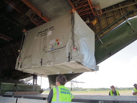
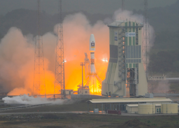
The first two satellites for Europe’s Galileo global navigation satellite system were lofted into orbit October 21 by the first Russian Soyuz vehicle ever launched from Europe’s Spaceport in French Guiana in a milestone mission, reports the European Space Agency (ESA).
The launch occurred one day after initially scheduled to resolve a problem with the ground-support fueling system.
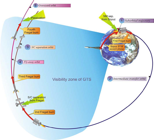
The Soyuz VS01 flight, operated by Arianespace, started with liftoff from the new launch complex in French Guiana at 10:30 UTC on October 21. All of the Soyuz stages performed as expected and the Fregat-MT upper stage released the Galileo satellites into their target orbit at 23,222 kilometers altitude, 3 hours 49 minutes after liftoff.
The two Galileo satellites are part of the In-Orbit Validation (IOV) phase that will see the Galileo system’s space, ground, and user segments extensively tested. During initial operations, the satellites will be controlled by a joint ESA and CNES French space agency team in Toulouse, France. Once that week-long phase ends, the satellites will be handed over to the Ober-pfaffenhofen Galileo Control Centre near Munich, operated by the DLR German Aerospace Center, which will be responsible for routine operations. Operating the satellite payloads to provide navigation services will be the task of the Fucino Control Centre, near Rome, operated by Telespazio.
The next two Galileo satellites, completing the IOV quartet, are scheduled for launch in summer 2012. Together, alll four are intended to prove the design of the Galileo system in advance of the other 26 satellites.
These first four satellites, built by a consortium led by EADS Astrium Germany, will form the operational nucleus of the full Galileo satnav constellation. According to ESA, the satellites combine the best atomic clock ever flown for navigation — accurate to one second in three million years — with a powerful transmitter to broadcast precise navigation data worldwide.

Artist’s depiction of a Galileo satellites being ejected from the dispenser.
Second IIF Good Now
The second GPS Block IIF satellite, SVN63/PRN01, launched in mid-July, was finally set healthy on October 14. The delay in bringing the satellite into service was due, in part, to extended testing of the cesium atomic frequency standard (AFS) on the satellite.
GPS IIF satellites carry three AFSs: one cesium and two rubidiums. The performance of the cesium AFS, independently confirmed, was poor. A switch to one of the rubidium AFSs took place on October 5.
U.S. Agencies Speak Out on LightSquared; Others Hide Their Cards
The U.S. House of Representatives Committee on Science, Space, and Technology has released some of the impact statements provided by federal agencies to the National Telecommunications and Information Administration (NTIA). The reports reveal deep concerns about and opposition to the LightSquared proposal, and detail cost estimates and other adverse impacts to government-wide operations should it go forward.
The NTIA itself has refused to make these agency reports public, rebuffing a Freedom of Information Act (FOIA) request by GPS World magazine and, so far, giving the same response to congressional committees on both the House and Senate side.
Missing in Action. The House Committee does not yet have access to all the agency statements; still missing are those from:
- the Department of Homeland Security,
- the Department of Commerce,
- the National Oceanic and Atmospheric Administration,
- the National Institutes of Standards and Technology.
The House committee has written to those departments asking for their reports; GPS World has also filed further FOIA requests specifically with those agencies. The Department of Defense impact statement is presumed to be classified.
Seventy-Two Billion. The Federal Aviation Administration (FAA) impact statement is the strongest statement of those provided so far to the House committee. It asserts, among many other findings, that the LightSquared proposal would cost the aviation community at least $72 billion, preclude elimination/reduction of an estimated 794 air-traffic fatalities over the next 10 years, set back planned air-traffic safety and efficiency measures by that same period, affect U.S. leadership in aviation, and damage the international market for U.S. satellite technology.
“FAA cannot conclude that operations using just the lower portion of the spectrum are compatible with civil aircraft receivers without definition of LightSquared’s end-state deployment and further study,” the FAA said. “Proposed LightSquared deployment (both upper and lower channels by 2014) would result in an estimated aviation community cost impact of at least $72 billion and delay NextGen implementation by approximately 10 years.
“Proposed LightSquared operations would severely impact the efficiency and modernization of the safest, most efficient aerospace system in the world.”
Not Feasible. The National Aeronautics and Space Administration stated, in part:
“NASA feels that due to the severity of the operational impacts, to both government and commercial users, it is conclusive that LightSquared’s implementation on the upper 10-MHz is not feasible in the near or long-term.”
Constellation Updates from ION-GNSS
During the Civil GPS Service Interface Committee (CGSIC) meeting held in conjunction with the ION GNSS 2011 conference in September, several presentations were given on the status and future of the global navigation satellite systems. Here are highlights, with updated information from elsewhere:
GPS. As of today, 30 satellites are in operation and set healthy. SVN27/PRN27, a Block IIA satellite launched in 1992, was decommissioned on August 10, 2011. The satellite has been removed from broadcast almanacs but continues to transmit L-band signals, presumably for end-of-life testing.
SVN35 returned to active service, once again, this time as PRN30, on August 16, to replace SVN30/PRN30, which was decommissioned from active service on July 20. SVN35 is being moved to the B1-F slot, previously occupied by SVN30.
There are currently four backup or residual satellites: SVNs 30, 32, 37, and 49. SVN30 is deemed no longer usable and there are plans to dispose of it.
SVN24/PRN24, a Block IIA satellite launched in 1991 and the second oldest active GPS satellite, reportedly experienced a reaction wheel failure on September 30. It has stopped broadcasting L-band signals.
GLONASS. Currently, 23 GLONASS satellites transmit usable L-band signals; 22 are set healthy. The first GLONASS-K1 satellite is still undergoing flight tests and is set unhealthy. According to Sergey Revnivykh, deputy director general, Central Research Institute of Machine Building of the Russian Federal Space Agency, the satellite will likely not be set healthy for users in the near future, not even for just the legacy FDMA signals. It will be considered a backup satellite that could be pressed into service if necessary. This decision was taken based on the fact that five GLONASS-M satellites are scheduled to launch this fall — indeed, one did so on October 2 — and they should be adequate to maintain a healthy 24-satellite constellation for some time. The current GLONASS signal specification cannot handle more than 24 operational satellites.
CDMA signals will be available to users from in-orbit GLONASS-K satellites by 2014.
QZSS. The Japanese press reported that a government ministerial council consisting of the entire cabinet and headed by Prime Minister Yoshihiko Noda has taken the decision to expand the Quasi-Zenith Satellite System to seven satellites and will seek 4.1 billion yen (about $53 million) in the fiscal 2012 national budget to start the process. According to Hiroshi Nishiguchi of the Japan GPS Council, QZSS has a top priority in the budget.
The future QZSS constellation structure is still under design. Nishiguchi stated that the constellation could involve a mixture of inclined geosynchronous orbit (IGSO) and geostationary Earth orbit (GEO) satellites. For a seven-satellite constellation, options include three IGSOs + four GEOs, or four IGSOs + three GEOs, or five IGSOs + two GEOs. He said that hopefully the funding and the future constellation structure will be known by the end of the year.
Beidou-2/Compass. A special Compass workshop (see also the October issue of GPS World) stated that there are nine Compass satellites “in service.” But that may not be correct. While nine Beidou-2 or Compass satellites have been launched, Beidou G2, the first GEO to be launched, appears to be uncontrollable and is in a librating orbit. Some reports, perhaps overly optimistic, claim this satellite is undergoing “in-orbit maintenance.”
The last IGSO satellite to be launched, Beidou IGSO4, may not be in service yet. One workshop presenter indicated that the currently used constellation consists of three GEOs and three IGSO satellites. It seems that the medium Earth orbit (MEO) satellite, Beidou M1, is not considered useful for actual applications at the present time. It was also stated that this satellite is undergoing “in-orbit maintenance.”’
Two more Beidou-2/Compass satellites are to be launched in 2011 and five satellites are to be launched in 2012 to bring the number of operational satellites to 14 by the end of 2012: five GEOs, five IGSOs, and four MEOs. This is a sufficient number of satellites to provide the planned regional Phase II service. A 30-satellite global service, expected by 2020, will reportedly use three GEOs, three IGSOs, and 24 MEOs.
Beidou-2/Compass will also offer a 1-meter level differential service.
A Beidou-2/Compass Interface Control Document (ICD) is to be published this month. As of press time for this magazine, it had not yet appeared.
— Richard B. Langley