A U.S. judge dismissed the bulk of two lawsuits by LightSquared and equity owner Harbinger Capital Partners, reports Reuters. The suits accused Trimble, Garmin and Deere & Co. of misleading them about interference concerns and hastening the company’s fall into bankruptcy.
In an opinion issued Feb. 5 in Manhattan federal court, Judge Richard Berman threw out Harbinger’s lawsuit, and denied nine of 11 claims by LightSquared.
LightSquared has been in bankruptcy since 2012, when the Federal Communications Commission revoked its license to build a planned wireless network over concerns it could interfere with GPS.
The lawsuits alleged that Deere, Garmin International , Trimble Navigation Ltd, and a GPS industry group led LightSquared to believe the planned network would not pose an interference risk. It wasn’t until LightSquared had pumped $4 billion into the project, the plaintiffs argued, that the GPS industry voiced their concerns.
Judge Berman dismissed many claims from both plaintiffs, including breach of contract and civil conspiracy, leaving alive only LightSquared’s claims for negligent misrepresentation and constructive fraud.
Because the judge did not dismiss all claims, LightSquared could still be able to probe the GPS companies’ books and records during discovery.
Despite major GPS fitness device OEMs announcing new fitness products at January’s International Consumer Electronics Show in Las Vegas, it looks like an increasingly difficult battle between smart devices and wearables, according to analysts at ABI Research.
Garmin launched its Vivofit fitness band and Vivoki/Vivahub corporate wellness solution. Magallen is one of the few companies in the GPS device OEM space that continues to show flashes of innovation, opening up its Echo watch platform to a range of third-party smartphone application developers.
At the high-end of the GPS fitness watch market, Polar has launched a new multi-sport watch, which features a barometric pressure sensor, support for new features such as a cycling power pedal. TomTom has launched an iOS application that links its current GPS watch range to an iPhone via Bluetooth.
In ABI Research’s quarterly GPS/GNSS Device tracker, the impact of these new device categories on dedicated GPS fitness device growth can be fully seen. Senior analyst Patrick Connolly comments, “Our forecasts for the overall GPS-enabled fitness area remain strong, hitting $2.6 Billion in 2018, but as was the case with turn-by-turn navigation, converged devices and wearables will take an increasing part of the available market. The adage of keeping what we have is important here, retaining a firm eye on growth in professional users, with hardware and in particular eyewear, a major distinguisher.”
Practice director Dominique Bonte adds, “Of the announcements, Garmin’s move into corporate wellness was the most striking. We are about to see a huge technological shift in the corporate/business sector, around BYOD, BYOW, wellness, security, and efficiency. What is interesting is that Garmin does not include a location element, which will be a core enabler in this sea change.”
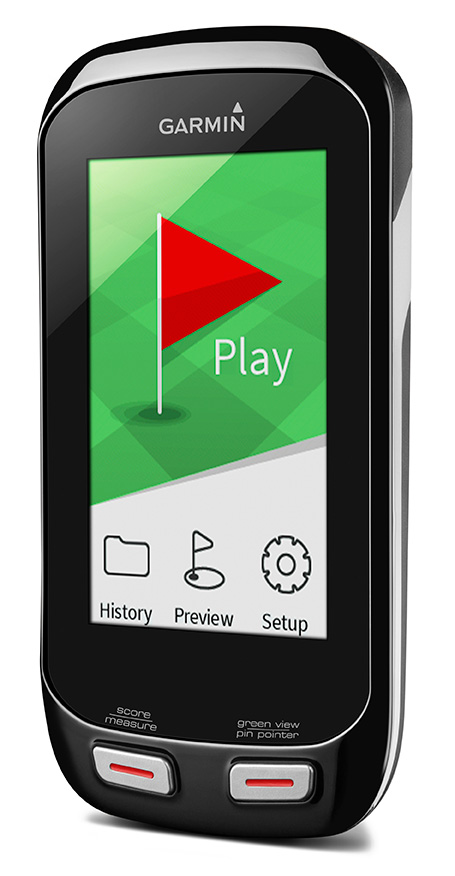
Garmin International has introduced two new handhelds geared for the golf aficionado, including a new top-of-the-line model, the Approach G8.
The Approach G7 and G8 golf handhelds have color touchscreens, more than 30,000 preloaded international courses, a rechargeable battery capable of multiple rounds, and new measurement features such as PlaysLike Distance, which shows adjusted range for uphill and downhill shots.
For golfers who prefer to leave their smartphones in their bags, the new Approach handhelds offer Smart Notification technology, which lets the user pair a compatible iPhone 4S or later to receive emails, texts, and call alerts on the device (Android compatibility is expected in the second quarter of this year). The devices are also compatible with Garmin Connect, so users can upload their scores and track their progress over time.
Both the Approach G7 and G8 incorporate the new measurement feature PlaysLike Distance, which adjusts distances for uphill and downhill shots, so players get the most accurate yardage measurements. Both devices also offer Club Advice, which remembers how far users hit each club and makes recommendations based on shot distances.
Another new feature in the G7 and G8 golf handhelds is the Big Numbers mode, so users can easily see the vital information they need without squinting or reading glasses.
The Approach G7 and G8 handhelds come preloaded with more than 30,000 international courses, with no extra subscriptions or fees. Both devices give precise distance to the front, back and center of the green, as well as layup and dogleg distances. Both devices have a rechargeable battery that plays an entire weekend of golf (15 hours) on a single charge.
The Approach G7 and G8 double as digital scorecards with scoring options for Stroke Play, Stableford, Skins and Match Play with adjustable handicaps. Users can save, review, share and print scores for up to four players. With the vibrant screen, the G7 and G8 offer colorful layup arcs at 100, 150, 200 and even 250 yards, so users know exactly how far to hit when laying up.
The Touch Targeting feature lets users touch any point on the display, and will give the precise distance to that exact spot, no matter if it is on the fairway, a hazard, a landing area, or even the front, middle or back of the green.
Like other Approach devices, the G7 and G8 have Green View, which allows users to zero in on a map of the green and manually position the pin in order to get the most accurate yardages. There is also an advanced Stat Tracking feature in the G7 and G8, which keeps track of fairways hit, greens in regulation and putts per round. These stats can be viewed during the round, or can be downloaded afterwards.
The premium Approach G8 also provides blind shot assistance with the new PinPointer feature, which shows the user the exact center of the green even if it’s not visible, and points them in the right direction for more accurate blind shots. Additionally, it adds Wi-Fi, so the G8 will automatically update courses when connected to Wi-Fi at no additional cost. The G8 rounds out the Approach family as the top-of-the-line golf handheld from Garmin.
New to the Garmin golf lineup, the Approach G7 and G8 will now be compatible with Garmin Connect. With the recent revamp of the online community, owners with Approach G7 and G8 will be able to upload, analyze and share their scorecards, as well as other data like fairways hit, greens in regulation, shot distance and number of putts. Users can keep track of whom they’ve played against, and who won each round. They can analyze course data, and see hole-by-hole details to understand their own trends and tendencies to improve their game. This is great to track users’ progress and improvements over time for every course they play.
Rugged, and with a water rating of IPX7, the Approach G7 and G8 are durable enough to withstand a rainstorm, or users’ golf bags without fear of damage. The Approach G7 and G8 will be available in Q1 2014. The Approach G7 will retail for $299.99 and the Approach G8 will retail for $399.99, and will be available at specialty golf retailers, golf course pro-shops and on garmin.com.
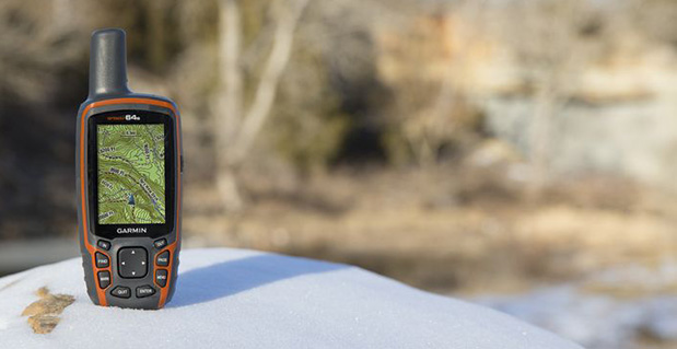
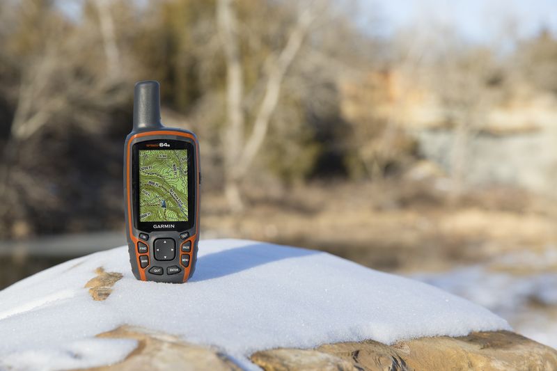
Garmin International Inc., a unit of Garmin Ltd., today announced the GPSMAP 64 series of rugged outdoor handhelds. The GPSMAP 64 series brings a dual GPS and GLONASS receiver, preloaded geocaches and smartphone connectivity for LiveTrack and Smart Notification to its product line for hikers, hunters, and geocachers.
“Building on the popularity of the GPSMAP series, the new GPSMAP 64 series improves functionality to make a top-notch device even better,” said Dan Bartel, Garmin vice president of worldwide sales. “The GPSMAP 64 is ideal for anyone, no matter if it’s their first handheld, or if they’ve used Garmin for years. It combines trusted Garmin technology with the comfort of a device people know and love.”
The GPSMAP 64 series has a 2.6-inch sunlight-readable transflective color display and a high-sensitivity GPS and GLONASS receiver with a quad helix antenna for superior reception. With the addition of GLONASS satellites, the time it takes for the receiver to lock on to a position is (on average) approximately 20 percent faster than using GPS alone. This allows users to get their position quickly and precisely even in heavy cover and deep canyon.
The GPSMAP 64 series features three distinct water-resistant (IPX7) models to suit various activities and interests. The basic GPSMAP 64 includes a built-in worldwide basemap with shaded relief, and supports BirdsEye Satellite imagery and TOPO U.S. 24K maps. The GPSMAP 64s adds a 3-axis electronic compass and barometric altimeter. Additionally, the 64s adds wireless connectivity for data transfer between other compatible Garmin handhelds and mobile apps, and for Smart Notification technology. With this, users can receive emails, texts and alerts on the device (when paired with an iPhone 4S and later). This allows users’ smartphones to be safely protected from the elements. The 64s also comes with a one-year subscription of BirdsEye Satellite Imagery. The GPSMAP 64st includes preloaded U.S. 100K topographic maps. With this, users will be able to search for points of interest by name or proximity to their location and view descriptive details for terrain contours, topo elevations, summits and geographical points.
For outdoor adventurers, the rugged GPSMAP 64 devices are compatible with BaseCamp, a free software download that allows users to view and organize maps, waypoints, routes and tracks. The 64s and 64st models are compatible with the BaseCamp mobile app for data transfer, and the Garmin Connect mobile app, for features such as LiveTrack. With LiveTrack, users can pair their device with the app, and invite friends and family to follow their activity in real time. This provides peace of mind, especially if users are alone. Through ANT+, the 64s and 64st models are also compatible with external sensors such as an external temperature sensor and heart rate monitor. With ANT+, the 64s and 64st models can act as a remote for the new VIRB and VIRB Elite action cameras.
Each device comes preloaded with the locations of 250,000 geocaches from Geocaching.com. Devices store and display key information to find the hidden containers including the geocache coordinates, terrain rating, its difficulty, hints and descriptions, so users no longer have to manually enter coordinates or print out geocache info. By going paperless, users are helping the environment, and improving their efficiency. If users would like to continue geocaching beyond the preloaded geocaches, when they register their device they can sign up for the free premium membership trial through Geocaching.com, and download more geocaches. The GPSMAP 64 devices can store millions more, so users will no longer have to pick and choose which geocaches they want to load on their device.
All of the devices in the GPSMAP 64 series have a dual-battery system, where both standard AA batteries and a rechargeable NiMH battery pack (sold separately) can be used. The devices have internal memory (4GB for 64/64s and 8GB for 64st), and a microSD card slot to store additional data and maps.
The new GPSMAP 64 series will be available this month. The GPSMAP 64 will retail for $299.99, the GPSMAP 64s will retail for $399.99, and the GPSMAP 64st will retail for $499.99.
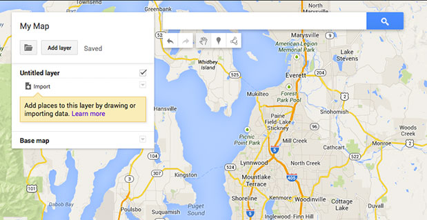
Google Maps aren’t just for finding directions for consumers. The company is courting small businesses to grab a greater market share and provide differentiation from its competitors. In a slow news month, it appears Google, the 800-pound gorilla in the location industry, has a strong start in business markets.
Google’s recent decision to roll out Maps Engine Pro, its software that allows small business to use the company’s location tools to create maps from location databases, is a solid step in the business-to-business market. However, the company also said there will be a mobile application for Maps Engine Pro, called Google Maps Engine, which will allow small businesses and users to edit and create maps while mobile.
Companies can use the app to optimize personnel and assets, build mapping apps, and create internal and external maps that use data layers to make business decisions. Depending on licensing, Maps Engine Pro costs $5 per user, per month — or $50 per user, per year.
One reason to roll out the enterprise product: Brian McClendon, vice president of Google Maps, said that there are 1 billion monthly active Google Maps users, making the business product familiar to companies who want to plot location data.
Magnetic Indoor Positioning?
Although much-hyped in the last two years, most indoor positioning has been powered by both GPS and Wi-Fi positioning in most tests and rollouts worldwide. However, a startup called IndoorAtlas, which recently opened an office in Sunnyvale, California, and partnered with Finnish grocery chain Fonella, according to published reports, is using magnetic technology via compass chips in smartphones.
Rather than using Wi-Fi signals to triangulate a device’s location, IndoorAtlas tracks differences in the Earth’s magnetic field to pinpoint location within a building. The magnetic field is all around most objects and animals. On the company website, this tidbit is found: “Many animals utilize local variations in the Earth’s magnetic field to find their way around. These magnetic variations commonly exist inside buildings as well. Many sources can contribute to these variations including Earth’s magnetic field, and the structures of the building. Modern smartphones can sense and record these magnetic variations to map indoor locations.”
IndoorAtlas’ technology doesn’t require additional infrastructure like wireless access points, so the technology can be used by retailers. Other markets include search and rescue, museum tours, and a navigation aid for disabled people.
Location Companies Going After Higher End Markets As Commoditization Settles In
As location technology, specifically GPS, becomes more of a commodity as many industry observers say, companies are looking at higher-margin market segments. For instance, Garmin, which has seen the portable navigation device market decrease, has been focusing on more expensive and specialized products.
While still a big business for Garmin, PNDs’ market share has been eroded by tablets, smartphones — and even expensive installed telematics systems, which have grown with the connected vehicle’s rise.
Garmin has offered several different types of high-end watches for swimmers, pilots, runners, golfers and others in the outdoor market. The newest entry is a $450 watch called Tactix, which any Navy SEAL could love. It features an altimeter, barometer, and jumpmaster software for airborne operations, and it’s even waterproof to a 50-meter depth.
LBS Insider to Cover CES in January
LBS Insider will be on site in Las Vegas to cover the huge Consumer Electronics Show. At CES, the connected vehicle market continues to be showcased. In published reports, Scott Keogh, Audi USA president, said that the company will make announcements about Audi Connect at the show.
T-Mobile US provides 3G connectivity to Audi’s Connect service in the United States through an embedded SIM in the car’s dash. T-Mobile’s plan, which includes Wi-Fi for as many as eight devices, is offered to new and existing owners of cars equipped with Audi Connect. It costs $450 for data services for 30 months — or users pay $30 per month if they select the month-to-month option. Some of the features includes access weather, real-time news and fuel prices. Both Google Earth and Google Voice are offered.
At CES, the LBS market has been de-emphasized by wireless carriers in the past three years. Instead, most location-related panels have been dedicated to connected vehicles.
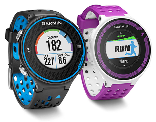
Garmin International Inc., a unit of Garmin Ltd., the global leader in satellite navigation, is now offering the Forerunner 620 and Forerunner 220 GPS running watches, both of which have color displays. The Forerunner 620 offers advanced features like recovery advisor, race predictor and VO2 max (maximal oxygen uptake) estimate to help runners train and achieve race goals. When used with the new HRM-Run (heart rate) monitor, the 620 also provides feedback on running form.
For indoor training, such as on a treadmill, the 620 and 220’s built-in accelerometer tracks distance and pace, so runners don’t need a separate sensor. Both models boast Garmin’s unique one-inch Chroma color display to easily interpret data.
“Whether running indoors or out, Forerunner 620 and 220 will change the way runners look at training,” said Dan Bartel, Garmin vice president of worldwide sales. “Advanced features in the 620 such as recovery advisor, VO2 max estimate, race predictor and stats on running economy, combined with connected features and training plan options found in both the 620 and 220, make these watches must haves for runners of all levels. To keep runners motivated the watches also notice if runners hit any personal records on that run, like their fastest mile, 5k, 10k, half or full marathon or their longest run to date.”
Regardless of a runner’s experience, motivation, or how far or fast they go, they likely want to know how they can improve and objectively measure their fitness. Forerunner 620 does just that by estimating runners’ VO2 max, which is a good indicator of athletic capability. Previously, the only way to accurately obtain VO2 max was by paying for a lab test.
When used with a heart rate monitor, the 620 incorporates several pieces of data, like running speed, beats per minute and heart rate variability, into an advanced algorithm to estimate runners’ VO2 max. The number itself indicates the maximum volume of oxygen a runner can consume per minute, per kilogram of body weight at their max performance. Theoretically, the more oxygen runners can use during high-level exercise, the more energy they can produce. A color gauge on the watch display shows how a runner’s VO2 max data compares to other individuals of their gender and age range. Based on the VO2 max estimate, the 620 can predict a runner’s race time for several distances. This can give runners a time target for their next race, assuming they’ve completed proper training.
When wearing HRM-Run, Forerunner 620’s recovery advisor and recovery check take the guesswork out when it comes to planning recovery time between hard workouts. Just like a coach, it learns the runner and their physiology based on heart rate data, so it factors this against their last workout and then shows how much time before they are fully recovered and ready for their next hard running workout. Color-coding on the high-resolution Chroma display gauge makes it easy to interpret — green means they are good to go. When runners see red on the display and a recovery time of more than three days, they might consider taking a rest day or just doing a light recovery run.
HRM-Run also has an accelerometer in the module that measures torso movement in order to calculate 3 different running metrics:
Cadence — the number of steps per minute. It displays the total steps (right and left combined)
Vertical oscillation — the bounce in runners’ running motion. It displays the vertical motion of a runners’ torso, measured in centimeters.
Ground contact time — the amount of time in each step that you spend on the ground while running, measured in milliseconds.
Thanks to their Bluetooth Smart wireless upload capabilities, Forerunner 620 and 220 can send runners’ run data to the Garmin online community, Garmin Connect, without being connected to a computer. It can transfer the data through the Garmin Connect Mobile app on their compatible smartphone. Additional connected features include live tracking, which allows runners’ friends and fans to follow along and see their stats in real-time. Runners must have their phone paired with their 620 or 220 throughout the run to use the LiveTrack feature. Victories, goals achieved and successes can be shared on runners’ social media sites by posting updates through the Garmin Connect Mobile app.
With the growing popularity of the run/walk training method in the distance running community (example: a runner runs for five minutes, walks for one minute and repeats for the duration of the course), Garmin has included a run/walk alert. This alert allows Forerunner 620 and 220’s other features, such as, Auto Lap and Auto Pause, to remain active during a run/walk session.
Both Forerunner 620 and 220 are water-resistant to 50m and can stand up to much more than rain, sweat and splashes. The Forerunner 620 has a touchscreen display responsive enough that it can be operated with running gloves, while the 220 is operated with easy to push buttons. Both models have rechargeable batteries lasting up to six weeks in watch mode and up to 10 hours in training mode.
Besides my family and friends, two major influences have guided my life. One is GPS, and the other is flying, although I’m not a pilot. Most of the flying was on business trips for GPS. I’ve been writing a book about my experiences and how I helped in a small way to bring GPS to the world. I estimate I’ve spent about eight months aboard airplanes, logging almost 2.5 million miles. During that time, I visited many places throughout the world, acting as a catalyst to promote the use of GPS and to obtain GPS business for my employers and for myself. I kept an extensive log of my travels and it enabled me to recreate much of what happened, and my impressions of why events occurred.
In 1968, after two engineering degrees and five years working in communications systems, I met a business development director from Magnavox, which had teamed with Hughes Aircraft, where I worked, on a study contract. We both attended a briefing on the contract status; that day was my first encounter with what would become known as GPS.
I attended one more meeting about the 621B satellite program. The U.S. Air Force had no funding for a full-up 621B, so instead it focused on proving that the technology was viable. We were asked to bid on supplying a receiver that would precisely measure a half-mile of cable using a spread-spectrum signal. I vividly recall a Hughes VP stating that 621B would never go anywhere, and besides, Hughes was only interested in building synchronous satellites. Our 621B competitor, TRW, agreed take the follow-on contract. TRW was acquired by Northrop Grumman in 2002. The Air Force felt it needed two competitors in case one failed, so it offered a second contract to Magnavox. The company took the contract, which became its first hardware entry in the world of GPS.
Before long, I received an offer from Magnavox to join the world’s leading experts on implementing anti-jam communications systems using then-classified, direct-sequence spread-spectrum technology. Magnavox had been working in the field since it was formed in the early 1960s, building the first anti-jam modems for the Initial Defense Communications Satellite Program (IDCSP) and now pursuing a follow-on program. Its main business areas were satcom, tactical communications, and positioning programs such as the 621B receiver. There also was a group building Transit satellite receivers for the Navy. Transit was really the first navigation satellite, growing out of experiments at Johns Hopkins University Applied Physics Lab, using Sputnik signals to determine one’s position on Earth by tracking the Doppler signal of a satellite in a known orbit. Besides the Naval Research Lab, Magnavox built the only Timation receivers, an early competitor to GPS for solving military positioning needs using a satellite system.
While I was still working at Magnavox on satcom, the 621B receiver was completed and we proved you could use a spread-spectrum signal to accurately measure distance. Once again, the Air Force did not have funds to launch navigation satellites so it proceeded with a new effort called “621B User Equipment Definition and Experiments Program.” The prime contractor was Grumman Aircraft. The idea was to put four transmitters on the ground and have an aircraft with a receiver fly over them and try to determine the aircraft’s position. The signals were to look as if they came from four satellites and were received by an antenna on the bottom of the plane. Grumman decided to use a receiver built by Hazeltine, which had some experience in spread spectrum but nowhere near as much as Magnavox. For this reason, the Air Force leased another receiver from us, asking how much? We came up with the number $450,000, our development and build cost. They agreed, and we called the receiver the MX450. It flew beside the Hazeltine receiver on the NC-135 aircraft at the White Sands Missile Range. Most of the usable test data came from the MX450, showing residual errors between the aircraft solution and the range tracking system to be less than five feet. This data was crucial in getting DoD approval in 1973 to proceed with Phase 1 of GPS. But we should have called it the MX495 because we overran the cost by $45,000.
A Tale of Two Contracts
The procurement for Phase 1 GPS came together as two major contracts. There would be a small number of satellites that Rockwell would win competitively and would lead to many years and billions of dollars in future GPS satellites, as it became part of Boeing Corp. ITT would build its own payload and go on to be the major supplier of GPS payloads to this day. The other contract, a study contract, was awarded to three companies: General Dynamics Electronics (GDE), Philco-Ford, and Grumman. Two of the contractors performing that study, which ended in proposals for the design of the ground network and several types of user equipment (GPS receivers), would be chosen to create the designs. Then one of the two would be selected to actually implement Phase 1 of GPS.
After the first round down-select, we were now playing in the big leagues, GDE/Magnavox against Philco/TRW. The Philco leader, Jim Spilker, and our guru, Charlie Cahn, had to work together along with Rockwell engineers to define a common signal for GPS. The product of their work is still in use as it was defined then, at least for the civil C/A GPS signal. There were tradeoffs and compromises. The length of the short code was a contentious issue. TRW had built a 512-bit correlator, and Philco pushed that for the C/A-code. Cahn wanted 2048 bits to minimize inter-satellite signal interference. They compromised on 1024 bits. Charlie wanted a serially transmitted short code/long code for the military signal to enable long-code acquisition, a technique we had used in all our modems. But Spilker pushed for the codes to be transmitted in phase quadrature, a more elegant solution that prevailed. The need for a short code arose because the receiver could not acquire the long military signal unless it knew time to microseconds accuracy. The military code was very, very long. By first acquiring the short, repetitive C/A signal, the receiver could read its data and determine time close enough to make a long-code acquisition search practical.
The GDE/Magnavox team won the Phase 1 contract, and we were developing the first military and civil GPS user equipment (UE). Our Phase 1 UE contract included quantities of a 4-channel, high dynamics set for the F-4 fighter aircraft; a 2-channel aircraft set for the bigger and slower C-141 and helicopters; a manpack; and a civil aircraft set that looked like a TACAN and used only the C/A GPS signal. The three aircraft sets were called the X-set, Y-set and Z-set, respectively. Before long, Col. Brad Parkinson, director of the Joint Program Office, decided that there should also be a competitive high-dynamics set and another manpack, and awarded a contract to Texas Instruments. The USAF avionics laboratory wanted a piece of the GPS action so it awarded a what it called a “high technology” GPS UE contract to Rockwell Collins.
For various reasons, many not of its own making, Collins eventually became the number-one supplier of military GPS UE, long after Magnavox faded from the scene. (Hughes and then Raytheon eventually acquired the Magnavox GPS crew, where some of my former colleagues still work today.) The Collins unit flew in the C-141. Our X-set flew in a pod under the F-4. The complement of equipment, GPS receiver, navigation computer, power supply, and so on, was too big to be installed into the aircraft, so it was housed in the pod.
Building the Crew
To staff the contract required hiring many new engineers. We scoured our competitors and prior employers that had people experienced in the needed hardware and software disciplines, and were able to create a crew that went on to become major contributors to GPS developments for decades. Some started their own GPS companies, like Min Kao who, with Garry Burrel of King radio, later became the MIN and GAR in GARMIN. Another GPS company started by Magnavox people is CAST Navigation, a GPS simulator manufacturer.
The Magnavox Marine Division developed commercial Transit receiver and integrated shipboard navigation systems and survey systems. Later on, it pioneered GPS-based marine navigation systems and eventually split off into another company called Navcom, formed by Jim Litton, which later became part of John Deere. Several notable GPS experts from that Magnavox cadre like Tom Stansell, Ron Hatch (still with Navcom), and Jerry Knight are actively consulting today. So with all modesty, I have to say that I too was part of that original group who can claim some degree of fatherhood for GPS user equipment and receivers.
Over the next several years, I became an ambassador for GPS, traveling the world, particularly to visit potential military GPS users in NATO and at other allies. In the late 1970s, Magnavox and Collins were awarded the Phase 2 user-equipment developments. About a year before the production contract was awarded to Collins, I had left Magnavox to join Interstate Electronics (IEC), now a major part of L-3 Communications, to lead its efforts to become a military GPS user-equipment supplier. IEC had a unique technology for tracking submarine-launched ballistic missiles using a GPS translator tracking system. We succeeded in applying it to the DOD test ranges and for Trident missile tracking and submarine navigation. In my later years there, we eventually miniaturized the GPS receiver to the point where it could be applied to guiding missiles and projectiles.
After nine years at IEC, I decided to go out on my own as a consultant and formed Global Systems and Marketing, Inc. For the next 20 years I worked on various assignments from most of the major GPS companies and several small businesses that were trying to find a position in the GPS market. I also participated as an expert witness in many legal cases involving GPS, from patent disputes to accident reconstruction to parolee tracking.
Looking back now from the beginning of my retirement, I can obviously say I’ve learned a lot. Two things stick out in my mind:
Never believe the schedule and budget anyone offers up, because new developments will likely take longer and cost more than originally estimated;
When you stop being better, you stop being good.
I know the future holds more miraculous applications of GNSS technology because of all the brilliant, innovative people working in the field that I have met, and those that I haven’t met but have read about in places like GPS World. You are all very fortunate to be part of what I call the most important dual-use system (after the Internet) ever invented.
Len Jacobson is a retired GPS consultant, having worked in the field since 1968. He is still active in the Institute of Navigation, having been Western regional vice president twice and held leadership roles in several of its conferences. He lives in Long Beach, California. Visit his site at www.lenjacobson.com.
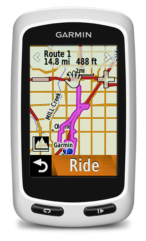
Garmin International Inc., a unit of Garmin Ltd., today announced the Edge Touring and Edge Touring Plus GPS navigators designed for touring cyclists, commuters, mountain bikers and those seeking navigation on their handle bars. Edge Touring and Edge Touring Plus work like a GPS navigator for a car, yet with bike-specific features, preloaded maps and points of interest to help cyclists to find their way. They provide both on-road and off-road navigation and can provide round-trip ride options based on a set distance.
The Edge Touring and Edge Touring Plus will debut at the Eurobike exhibition August 28-31 in Friedrichshafen, Germany (Hall A5, booth 201) and at Interbike in Las Vegas, Nevada (booth 11058), September 18-20, where they will be prominently displayed.
“The new Edge Touring and Edge Touring Plus are perfect for those whose bikes mean adventure, freedom, exploration and a way of life,” said Dan Bartel, Garmin vice president of worldwide sales. “Easy to set up, easy to use and preloaded with bike-specific maps, they will let riders navigate safely and securely to their destinations.”
Edge Touring comes preloaded with bike-specific maps that make it easy for cyclists to stay on the route and find their way back again. Whether cyclists are riding from A to B, asking Edge Touring to provide a round trip route, or following a ride that they have planned or downloaded from Garmin Connector Garmin Adventures, Edge Touring will guide them on their ride with clear turn-by-turn visual instructions. Cyclists can choose between Cycling, Tour Cycling and Mountain Bike modes to calculate the most appropriate route. Edge Touring will then guide cyclists on suitable roads or bike-paths to their destination. With the new round trip routing feature, cyclists need only to input the distance they want to ride and Edge Touring will do the rest. It will calculate up to three routes to choose from, including their distance and elevation profiles. Cyclists can compare the routes, choose the one to follow and are one tap of the screen away from turn-by-turn directions the entire way.
This Garmin video shows Edge Touring and Touring Plus in action:
Edge Touring is robust and water resistant and has a 2.6’-inch touchscreen that works in the wet and with gloves. It weighs less than 100g and fits on the stem or on the bars. The rechargeable battery will last up to 17 hours, and it is also compatible with optional solar external battery pack, which will give an additional 20 hours of ride time. Edge Touring displays key ride data such as time, speed, average speed, max speed, distance and much more. Cyclists can view from 1 to 10 fields on a clear customizable screen. Edge Touring comes with a quarter-turn bike mount and can be easily transferred between bikes.
Edge Touring records how far, how fast and where cyclists ride so users can replay, relive and share each ride in detail once it has been uploaded to Garmin Connect. Cyclists can share their own rides or search for ones others have completed in Garmin Connect or look for Adventures in Garmin’s free Basecampsoftware. Cyclists can also create custom courses within Garmin Connect and send them directly to their Edge Touring.
Edge Touring Plus provides all bike-specific features of Edge Touring, in addition to compatibility with ANT+heart rate monitors to help cyclists know how hard they are working, and will even display key data such as range or remaining charge from ANT+ compatible eBikes. It also includes a barometric altimeter for accurate elevation, gradient, ascent and descent data.
Edge Touring and Touring Plus are expected to ship fall 2013 and have a suggested retail price of $249.99 and $299.99 respectively.
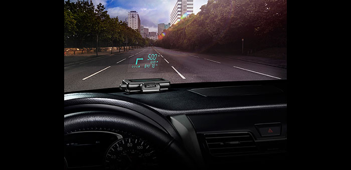
Garmin International Inc. has announced HUD, the company’s first portable head-up display for smartphone navigation apps. With the HUD display, drivers can view navigation directions projected onto a transparent film on the windshield or an attached reflector lens. Garmin said by providing comprehensive road guidance at a glance and right within the driver’s line of sight, HUD can help increase safety and reduce driver distraction.
HUD receives navigation information from a Bluetooth-enabled smartphone running a Garmin StreetPilot or NAVIGON app.
“Head-up displays currently have their place in select high-end cars, but HUD makes this technology available as an aftermarket accessory for any vehicle, at an affordable price,” said Dan Bartel, Garmin vice president of worldwide sales. HUD has an MSRP of $129.99. Garmin StreetPilot and NAVIGON apps, starting at $29.99 for a regional map (NAVIGON U.S. Central, East or West), provide premium turn-by-turn navigation for smartphones, including onboard maps, lane guidance, speed limit warnings, real-time traffic, and other features.
HUD offers more navigation details than other portable head-up displays, yet presents them in a simplified way that doesn’t divert the driver’s attention from the road, Garmin said. The directions are easy to follow and allow drivers to navigate even the most challenging interchanges and traffic situations with ease. HUD displays turn arrows, distance to the next turn, current speed and speed limit, as well as estimated time of arrival. It even lets drivers know what lane to be in for the next maneuver and alerts them when they exceed the speed limit, the company said. HUD also warns users of potential traffic delays and upcoming safety camera locations. The crisp display automatically adjusts the brightness level so projections are clearly visible in direct sunlight or at night.
Complementing the visual display, spoken turn-by-turn directions are provided simultaneously by a compatible Garmin or Navigon app, either through the smartphone speaker or a Bluetooth-connected car stereo. Music streamed to the car stereo from the smartphone will automatically fade out for turn-by-turn voice prompts. HUD also continues to display navigation information while taking incoming calls.
Users can choose between displaying HUD navigation information on their windshield, with the included, transparent film, or on to the included reflector lens that attaches directly to HUD. The device pairs wirelessly with a compatible Bluetooth-enabled iPhone, Android phone or Windows Phone 8. An integrated USB port on the vehicle power/adapter cable makes it easy to charge the smartphone while driving, Garmin said.
Game Golf, a wearable technology and integrated software platform for golf, is available for pre-0rder, and expected to be released this summer. Backed by professional golfers Graeme McDowell and Lee Westwood, it seamlessly records a player’s golf game to make the game more engaging, visual, interactive, shareable and social, both on and off the course.
“Game Golf not only gives everyone access to crucial data to dramatically improve your golf game and handicap, but it also makes playing more motivating, rewarding, social and fun,” said Graeme McDowell, 2010 U.S. Open Champion and Game Golf investor. “The product is extremely intuitive, doesn’t disrupt your game and is essential for any golfer looking to understand their game better, knock down their handicap, give themselves a competitive edge and compete with their friends and family across the globe.”
Game Golf is designed by fuseproject and Yves Béhar, CEO of fuseproject and Chief Creative Officer at Jawbone, the maker of the wireless Jambox speaker. The Game Golf elegant and discreet wearable device tracks the data around the course, and uploads the data automatically to an intuitive app which allows you to track, analyze and share the data collected. It tracks the most important statistics from your golf game, including club-by-club performance, fairway accuracy, greens in regulation and putting.
“The design of the Game Golf app and product has been closely integrated: a beautiful and dynamic presentation of play data, easy and fun ways to share, non-disruptive hardware and experience,” said Yves Béhar, CEO of fuseproject. “The design and user interface is crafted to deliver a 21st-century experience of the game.”
The product uses a combination of positional technology, motion sensors and near field communication to capture the golfer’s data from the course. The device is engineered to be power efficient and extend battery life beyond that of the average smartphone and provides two full rounds of tracking on one charge. Data from the device is synced to the cloud via Bluetooth to a smartphone or via USB to a PC.
“The golf community has been calling out for a product that tracks their game effortlessly, shares results with friends and provides intuitive data with which they can analyze to constantly improve their game — and Game Golf is here to provide that,” said John McGuire, CEO and Co-Founder, Game. “A new era of quantification and gamification is rapidly and radically changing the way we live, work and play. Existing golf technologies only provide technology that helps on the course, but we provide the complete package, giving you everything you need to improve your game and compete before, during and after you take to the course.”
A new group, the GPS Innovation Alliance, has formed and announced itself as the voice of the U.S. GPS industry and community of users, to “support the ever-increasing importance of GPS” in the U.S. capital, Washington, D.C. The organization subsumes and replaces both the U.S. GPS Industry Council, an entity of longstanding, and the Coalition to Save Our GPS, which arose in March 2011 in response to a Federal Communications Commission (FCC) conditional waiver granted to LightSquared.
The alliance appears to reflect a desire on the part of some industry members to take a more aggressive approach inside the Washington Beltway, a sign, it would seem, of the political times. Some of those involved spoke informally of a desire to take advantage of contacts made on Capitol Hill and in the media during the highly visible LightSquared combat, fought in the glare of media attention heretofore unknown in industry circles.
Members of the Alliance are drawn from a variety of fields and businesses reliant on GPS, as well as leading manufacturers of GPS equipment. The former group includes, aviation, agriculture, construction, transportation, first responders, and surveying and mapping, and consumer organizations representing users of GPS for boating and other outdoor activities, and in automobiles, smartphones, and tablets.
Joining John Deere, Garmin, and Trimble — three lead drivers of the Coalition effort at the FCC — are NovAtel Inc. and Topcon Positioning Systems. All five were previously long-time members of the USGIC, and they appear as founding members of the alliance at www.gpsalliance.org.
Affiliate members listed on the website include the Association of Equipment Manufacturers, General Aviation Manufacturers Association, National Association of Manufacturers, Association for Unmanned Aerial Vehicles International, and Boat Owners Association of the United States.
The alliance plans to build on “the proud heritage and extensive expertise of the United States GPS Industry Council (USGIC), which was formed in 1991 to promote broader commercial applications of GPS and to expand global markets while assisting in safeguarding the technology’s military advantages. The council has a long history of highly effective advocacy on behalf of the GPS industry, as well as serving as a trusted source of objective information for policy makers, the media and the public both in the U.S. and around the world.” The alliance website gives a longer statement about the history and record of the USGIC, highlighting its role in international negotiations.
Michael Swiek, executive director of the USGIC, has transitioned to become the executive director, executive branch and international, of the Innovation Alliance. In addition to working closely with leading offices of executive branch departments of the U.S. government, he will continue well-established dialogs with governmental, private sector and academic entities in areas critical to GPS and satellite navigation among key players in Europe, Japan, Russia, Korea, China, and elsewhere.
Heather Hennessey, a principal of Innovative Federal Strategies LLC, a “comprehensive government relations firm,” has taken the position of executive director, legislative, at the alliance. Hennessey has seven years of service in the House of Representatives, including two years as chief of staff for Congressman Jack Kingston of Georgia.
An active voice in alliance representations on Capitol Hill will presumably be that of Jim Kirkland, vice president and general counsel for Trimble. Kirkland was the most prominent spokesperson for the coalition during the LightSquared battle, which appears to be either over or nearly so. “The alliance is committed to ensuring constructive, robust dialog between GPS users, manufacturers and policy makers on critical policy issues affecting GPS,” Kirkland said, “a commitment Trimble is pleased to be a part of as the industry continues to innovate and modernize.”
The alliance mission statement cites the importance of GPS to global economy and infrastructure; vows to aid further GPS innovation, creativity and entrepreneurship; and to protect, promote and enhance the use of GPS.
The GPS Innovation Alliance officially launched on February 13 with a reception on Capitol Hill, a traditional lobbying tactic that previous efforts had perhaps not envisioned. The organization has also hired a public relations firm, Prism Public Affairs, and commissioned a logo.
Butler National Corporation, which specializes in the aerospace sector of structural modification, maintenance, repair, and overhaul, announces issuance of the Supplemental Type Certificate (STC) for installation of the new Garmin GTN series of navigators that provide GPS, navigation, and communications. The installation is for GTN 750 navigators in the Learjet Models 35/35A/36/36A with the FC-200 autopilot and the Learjet Model 24.
The Garmin GTN series features intuitive touchscreen controls and a large-screen display that give Learjet pilots unprecedented access to high-resolution mapping, graphical flight planning, and geo-referenced charting, among many other features. The installation also features new GPS roll-steering that allows seamless navigation operations with turn anticipation and waypoint sequencing interfaced to the autopilot.
“This approval offers a significant and economical avionics upgrade for the Lear 30 series airplanes,” said Clark Stewart, president and CEO of Butler. “The STC for the new Garmin GTN series allows us to tap into a sizeable upgrade market for retrofit of flight management systems. The Garmin GTN upgrade provides significant functionality upgrades, including WAAS GPS approaches and roll-steering interface to the autopilot.”
“We have designed the installation to provide cost-effective options to meet the various Learjet operator requirements. We will be offering the GTN Learjet installations through our avionics facility Kings Avionics starting under $100,000,” commented Craig Stewart, Aerospace division president.
Butler National Corporation operates in the Aerospace and Services business segments. The Aerospace segment focuses on the manufacturing of support systems for commercial and military aircraft including the Butler National TSD for the Boeing 737 and 747 Classic aircraft, switching equipment for Boeing McDonnell Douglas Aircraft, weapon control systems for Boeing Helicopter, and performance enhancement structural modifications for Learjet, Cessna, Dassault, and Beechcraft business aircraft.