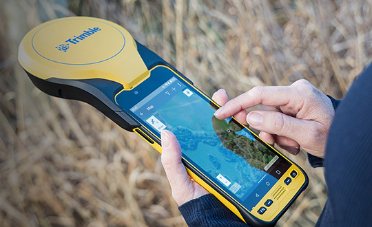
Trimble has announced a new high-performance data collector for its Mapping and Geographic Information Systems (GIS) portfolio — the Trimble TDC650 handheld. Built for GIS data collection, inspection and asset management activities, the TDC650 provides users a rugged solution with scalable high-accuracy GNSS positioning for professional field workflows.
The TDC650 is fully integrated with today’s demanding GIS data environment, powered by the Trimble Software Development Kit (SDK) that enables precision GNSS positioning for apps such as Esri ArcGIS Field Maps and Trimble TerraFlex software. The TDC650 is also a scalable solution that allows customers to choose their desired accuracy down to the centimeter-level to meet needs and budget requirements.
“This is an ideal tool for customers tasked with modernizing critical utilities including electric, gas and telecommunications networks,” said Gareth Gibson, marketing director, Trimble Mapping and GIS. “The precision, quality and data integration workflows needed to map the physical world to a digital one in these projects requires a modern data-collection platform like the TDC650.”
City, state and local governments and utilities will benefit from this solution, which is part of the larger Trimble Public Sector ecosystem that includes Cityworks software for stormwater inspections and Trimble Unity for monitoring municipal water pressure and hazards. As GIS data continues to grow more complex, Trimble helps simplify, visualize and make sense of the data so customers can make better decisions in managing their communities’ assets.
New utility network management extension combines advanced system of record with location-based analytics.
Esri, the geographic information system (GIS) technology and spatial analytics company, is releasing advanced network capabilities for utilities as part of the company’s ArcGIS platform.
The ArcGIS Utility Network Management extension, which delivers the new utility network, lets users create, manage and share complete data about networks from source to demand, such as residential meters for electric, water, wastewater, gas, district heating and telecommunications companies.
These network management capabilities enhance Esri’s current utility platform for handling billions of data elements while providing access to the utility network on any device, anytime, anywhere. For the first time, workers will be able to edit and trace the path of a network from a smart device while in the field and share information securely and more easily with those who need it. Previously, each utility subnetwork — like transmission lines, substations, and distribution and low-voltage networks — had its own separate GIS database.
The utility network provides a holistic system for every component of the utility supply chain right down to the customer, as well as the ability to store unprecedented detail on each of these components, which will be very important as utilities evolve to provide higher fidelity information to operational systems.
“We are very excited about the release of our next-generation utility platform,” said Jeff Rashid, Esri global director for utilities and communications. “These advanced capabilities will help utilities and telecoms provide greater details about their networks across their organization, at a rate of speed not seen in the past.”
The ArcGIS Utility Network Management extension allows the utility network to be completely cross-platform capable, meaning it is not confined to users of desktop GIS software. Before this innovation, location data was not easily accessible for fieldworkers or executives, managers, service technicians, and accountants who needed to have accurate, real-time understanding of utility assets.
In addition, Esri partners in the utility field will be able to use this network to add greater value to their workflow, create new solutions allowing personnel to be more efficient, and to better satisfy the needs of their customers.
“We are excited about the new capabilities in Esri’s utility network management platform and look forward to evolving the ArcFM Solution XI Series to offer utilities unprecedented value,” said Jay Stinson, general manager, Schneider Electric Geospatial Business. “This next generation platform enables us to build a world class ecosystem for managing the design and construction workflow. The continued strength of the historic Esri and SE partnership will help utilities realize the full potential of their GIS investment, equipping them to address the challenges facing today’s digital utility.”
Avineon Inc. has launched a new portion of the Avineon Innovation Lab dedicated to articles, white papers and videos highlighting the impact of Esri’s Network Management System in the ArcGIS Platform. Avineon is a provider of geospatial, information technology and engineering support services.
The new section focuses on Avineon’s contributions, expertise and partnership with Esri on the next evolution of GIS Network Management: the Utility Network.
Part of the ArcGIS platform, the Utility Network is available on any device.
GIS services and solutions have been a part of Avineon’s success for the last 25 years, which is keeping pace with evolving technology and the impact GIS has on companies in the utility and telecommunications industries.
The Utility Network lets users create, manage, and share electric, water, wastewater, gas, district heating, and telecommunications asset data. The beta release of the Utility Network comes with base data models for electric, gas and water networks.
The technology is capable of supporting other networks — such as district heating, telecommunication and wastewater — but, for now, users need to build their own data models or rely on partners. Esri will provide base data models in some of these areas in later releases.
“Avineon has been a valuable partner and contributor to Esri’s Utility Network throughout the early adopter program, providing valuable feedback to our product teams,” commented Bill Meehan, Director of Utility Solutions for Esri. “The resulting Network Management System in the ArcGIS Platform will support utility and telecommunication companies as they execute their business plans for innovation, digital transition and transformation, sustainability, and smart ecosystems (smart grid, smart buildings, smart transportation, smart cities, etc.). We believe Avineon’s partnership with Esri and offerings like Avineon’s Head Start program, as well as observations into the practical applications of the Utility Network, through their Innovation Lab, will help industries understand the strategic and tactical pathway to maximize the value of their GIS now and into the future.”
Joel Campbell, Avineon’s vice president of Commercial Systems, added, “As an Esri business partner, it is exciting to support our customers and contribute to Esri’s vision of the ArcGIS Platform. These new capabilities serve as the foundation for delivering a new generation of business applications leveraging web and services patterns as well as evolved network management capabilities. We at Avineon look forward to utilizing our Innovation Lab as an outlet to share the lessons learned, best practices, and case studies around the newest evolution of GIS and its impact on the utility and telecommunication industries.”
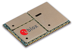
Bartec Pixavihas launched the “Impact X intrinsically safe smartphone” based on u-blox’ rugged 3G cellular module technology designed for devices used in tough industrial and outdoor environments. Bartec Pixavi is a manufacturer of mobile devices used in hazardous or explosive environments such as oil platforms, mines and chemical plants.
“Our Impact X smartphone is designed with the most robust, reliable and safe components available to ensure security and provide reliable connectivity to workers in potentially dangerous locations,” said Christian Rokseth, CEO of Bartec Pixavi. “We chose u-blox’ cellular module technology because of its industry-leading performance, excellent environmental tolerance and reliability.”
u-blox LISA u230 module. Photo: u-blox
The Impact X is CSA Class 1, Zone 1, IECEx and ATEX Zone 1 certified, explosion proof, waterproof and extremely ruggedized. At the heart of the Impact X is u-blox’ professional-grade LISA-U230 six-band 3G cellular module with 2G fallback capability. LISA modules also provide fully integrated access to u-blox GNSS receivers to enable advanced location-aware applications. Antenna diversity permits LISA-U2 modules to provide the highest data speeds.
“The Impact X is an excellent example of a high-performance mobile device that demands performance well beyond what is provided by standard mobile phones,” said Armin Boeshenz, General Manager of u‑blox sales EMEA. “We are extremely pleased to be a key module supplier to demanding customers such as Bartec Pixavi as proof of our industry-leading quality and reliability.”
u-blox LISA-U2 modules are suited for networks worldwide. Features include data-rates of up to 21.1 Mb/s (downlink), a rich set of Internet protocols, very small footprint, very low power consumption and extended operating temperature range of -40 to +85 degrees C.
PeopleNet, a Trimble company and provider of fleet mobility technology that optimizes performance and decision-making management, has launched a mapping and navigation solution for its Energy Services suite, serving U.S. fleets in the upstream and midstream sectors.
“Our Energy Services suite capitalizes on our proven fleet mobility solutions that increase efficiency, safety and compliance for all oilfield service segments, including producers, oilfield construction and well service companies, as well as haulers of fluid and crude oil. In addition, we’re leveraging our parent and sister companies’ industry-standard lone-worker, mapping and navigation technologies to fast-track development of new services to continue improving operations for Energy Services fleets,” said David Buhl, leader of PeopleNet’s dedicated Energy Services Division.
PeopleNet’s new Energy Services mapping and navigation solutions are based on exclusive, detailed maps of private and leased oilfield roads that facilitate vehicle navigation to and from well sites, coordination of disparate workforces to promote efficiency, location monitoring of equipment to ensure vehicles are on the correct route for least-cost routing. The Oil and Gas Map Portal is a web-based application used by back-office dispatch personnel to manage the navigation needs of vehicles and includes reporting, dashboards, and scorecards that help manage compliance with producer-landowner road-usage agreements.
CoPilot Oil and Gas Navigation is an in-cab application that uses oil and gas field mapping for providing turn-by-turn directions to the driver to enable on-time arrivals and scheduling. Location data, including wells, is installed onto the in-cab device and is accessible in the points of interest menu. When a location is selected, the application provides turn-by-turn directions to the driver.
A growing number of energy services fleets are using PeopleNet technology to promote on-time schedules, enhance service levels and improve safety/compliance, including Gibson, Missouri Basin Well Service, Nuverra Environmental Solutions, Rockwater, and Tankstar USA.
These new services are based on reliable two-way messaging and GPS, supported by tri-mode communications (cellular, satellite and Wi-Fi). They are being added to PeopleNet’s current Energy Services offerings, which include: Crude Workflow for improving driver efficiency; eDriverLogs HOS application with oil field regulations; Speed Gauge speed monitoring; and Automated Fuel Tax reporting for eliminating manual trip sheets.
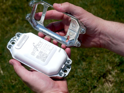
GT-1 asset tracker combines GPS, RFID, and Bluetooth technologies. Photo: Geoforce
Geoforce, Inc. is announcing commercial availability of its GT-1 asset tracking device that can track field equipment in locations and conditions previously too challenging for other devices to function effectively. A globally certified GPS device, the GT-1 enables oil and gas service providers to proactively monitor and share data on vehicles and equipment for more cost effective operations, helping to meet ongoing environmental responsibilities, the company said.
“We have been waiting a long time for a device like this,” said Michael Rolston, operations manager at Permian Equipment Rentals. “It’s small, it’s incredibly rugged, it will last years without replacement. It’s also surprisingly low cost — given all its features and capabilities.”
The GT-1 was previously offered in limited release to several major international service and rental companies beginning in the fourth quarter of 2012. To date, thousands have shipped and are actively tracking oilfield assets around the globe.
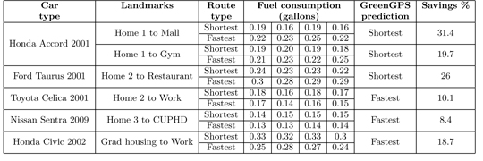
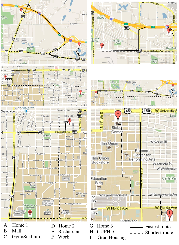
Most GPS devices in cars today give the driver two choices: shortest route or fastest route. GreenGPS provides a third option: most fuel-efficient route.
With gas prices skyrocketing, many drivers would be happy to spend a few more minutes on the road, or take a different route, if it meant burning less gas.
The answer could be the GreenGPS navigation service, now being developed by researchers at the University of Illinois at Urbana Champaign (UIUC), which finds the most fuel-efficient route for your vehicle.
“The most fuel-efficient route may be different from the shortest route because the latter may pass through downtown stop-and-go traffic,” explained Tarek Abdelzaher, project lead and computer science professor. “It may also be different from the fastest route because vehicles are not as fuel efficient at higher speeds.”
All cars manufactured in the U.S. since 1996 come with a standard interface to their internal gauges and engine measurements called the On-Board Diagnostics Interface, or OBD-II. GreenGPS runs on the driver’s GPS-enabled cell phone and uses an off-the-shelf wireless adaptor plugged into the vehicle’s OBD-II port to receive engine readings via Bluetooth.
The cell phone collects the readings and connects to a server that models the engine’s fuel efficiency and customizes navigation advice to the particular vehicle, Abdelzaher explained.
The best route computed by GreenGPS to the same destination may differ from one vehicle to another. “For example, my vehicle uses about 20-25 percent more gas in stop-and-go traffic compared to free-flowing traffic, whereas my wife’s car uses closer to 40 percent more,” Abdelzaher said. “GreenGPS may recommend to her a path that is longer but has no traffic, whereas it might recommend to me a path that incurs some traffic but is shorter.”
To users, GreenGPS looks like a regular navigation service. The driver specifies a destination, then ask the service to find a route. “It runs on your cell phone, except that in addition to the fastest and shortest route options, it offers the ‘least-fuel route’ option,” Abdelzaher said. “If the driver chooses that option, they receive the GreenGPS-recommended fuel-efficient route.”
The program works best with a small hardware addition to collect readings specific to the vehicle. “In order for the advice to be customized to the performance of your specific vehicle, the driver should invest in buying the OBD-II adaptor. It costs about $50 and is a one-time investment,” Abdelzaher said.
“If the driver does not wish to buy the adaptor, they can still use GreenGPS and supply the make, model, and year of their vehicle. In this case, GreenGPS will use data from other vehicles of the same make, model, and year, or vehicles as close to them as possible to compute the navigation advice,” Abdelzaher said. This social networking component is also being developed as part of the project.
The system pulls the GPS data from the driver’s cellphone. “If you use a GPS phone (and most smartphones have GPS), the system simply finds out your current location from your phone. Otherwise, you would need to supply both source and destination addresses (like you would when you get directions from Google Maps) and the system will show you the route on a map.”
Gas-Saving Pilots. In the first stage of testing, the team solicited volunteers to drive in the area of their university, in Urbana-Champaign, a city of 170,000. In all, 1,000 miles were driven by 16 different cars. Results demonstrated that following the fuel-efficient route saves on average 6 percent over the shortest route, and 13 percent over the fastest. “This was done on flat terrain and in the absence of significant congestion,” Abdelzaher said. “We expect that testing in higher traffic and richer topology will increase the variability in fuel consumption among different routes, resulting in even more potential savings when following the most fuel-efficient route. Verifying this conjecture is currently a topic of investigation for our ongoing research project.”
Abdelzaher said his team has just started the second stage. “In the second stage of testing, we will deploy GreenGPS on the UIUC Facilities and Services fleet (about 100 cars) and monitor performance over a longer period of time. Preparations for this deployment are currently under way. We also expect to offer GreenGPS publicly to any other volunteers who wish to help with testing.”
Impressed by early findings of gas savings, the second phase is being funded in part by a $300,000 grant from the National Science Foundation. Abdelzaher and Robin Kravets, another UIUC computer science faculty member, were awarded the grant this spring. It will help deploy GreenGPS among the campus fleet cars, and track and analyze the results.
“By sharing data on speed, fuel efficiency, and location of vehicles, better real-time navigation services can be developed that guide drivers to routes that are maximally fuel-efficient for their cars, hence reducing transportation carbon footprint,” the grant reads. “This project helps usher in a new era of sensing applications with more integration of humans, networks, and the physical world, which may have a significant impact on the economy, energy, and the environment by reducing transportation energy cost and carbon footprint.”
Other grant providers are the Office of Naval Research, which is funding research on the technology’s networking component, and IBM through its Smarter Planet initiative. As a part of this project, 200 or more cars in the Urbana-Champaign area of various makes and models will be fitted with GreenGPS. Through a social network of drivers, data and routes collected can be shared and used by those who don’t have the OBM-II adaptor installed.
Fuel consumptions for the various roundtrips between different landmarks.The landmarks and corresponding shortest and fastest routes.