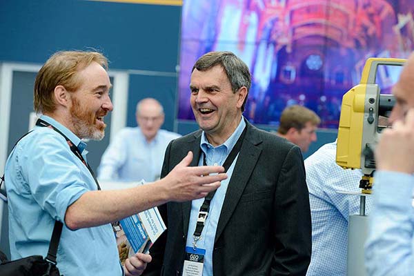
Topcon Positioning Systems attended GEO Business in London this month to showcase its latest solutions to improve survey and geospatial workflows.
The event, which took place at Excel London June 4-5, showcased hardware, software and workflow technologies across capture reality, surveying solutions, engineering surveys, and GIS mapping and utilities, including the company’s new suite of 3D scanning solutions. The scanning solutions offer integrated software that enables high-speed data capture and immediate analysis for a wide array of geomatics applications.
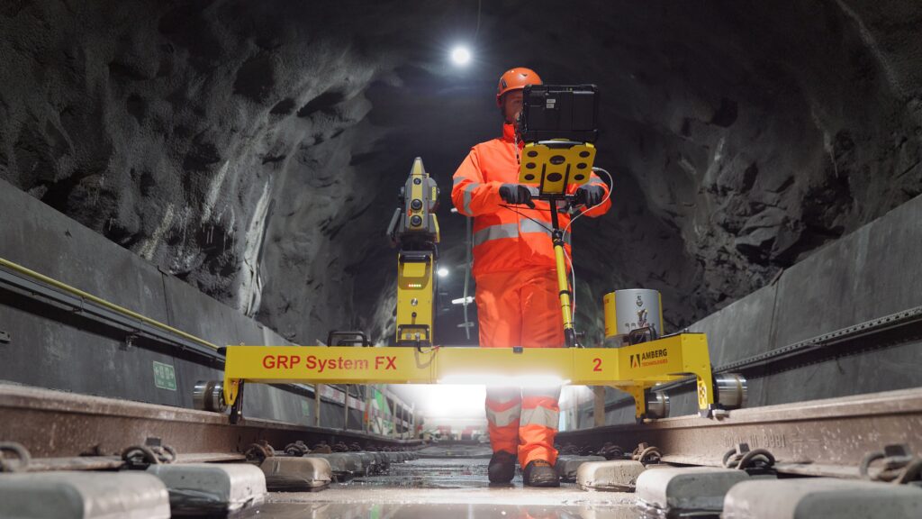
Topcon is partnering with Amberg Technologies on rail solutions. (Credit: Topcon)
“Smarter workflows for rail survey data”: Bruno Fileno, senior segment manager geomatics, gave an in-depth look at integration efforts between Topcon and Amberg Technologies that focus on how interoperable workflows streamline surveying tasks such as track alignment, geometry verification, and clearance assessment.
“Control, confidence, custody: How surveyors defend georeferenced SLAM workflows”: Phil Marsh, director of scanning sales EMEA, shared a practical framework for delivering georeferenced SLAM results, with tips on combining RTK with survey control and independent checkpoints, and building a lightweight QA pack to prove accuracy – producing outputs surveyors can get behind and clients can sign off.
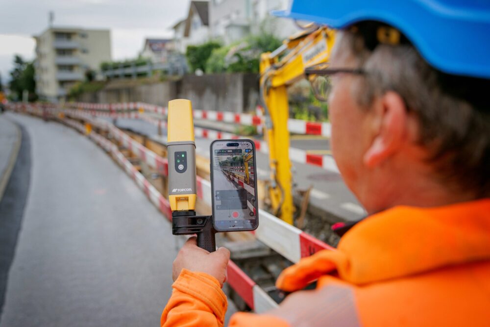
“From ground to cloud: Transforming utilities with accessible digital workflows”: Nathan Ward, business development manager, utilities solutions EMEA, explored the newest innovations in utilities mapping, explaining how seamless data capture with the Topcon CR-H1 handheld device and automated cloud processing can deliver date-stamped records that cut delays, reduce rework, and speed up sign-off and payment.
Diversified Communications, organizer of the GEO Business 2021 event, announced that the show will be moved from May 19-20 to Nov. 24-25. It will still take place at ExCel London.
GEO Business connects the data holders and processors with the people who benefit from the applications and insight, which geospatial information provides.
“Although all the signs are positive for a restart for large scale events from Easter, we feel May could be a little early to give everyone the best possible chance for a great show,” said Diversified Communications. “So after consulting with the geospatial community, we’ve made the tough decision to push GEO Business back to the autumn for one year.”
GEO Business will give attendees the opportunity to explore the latest geospatial technology, learn from industry experts, try technology before they it buy, grow their professional work and boost their careers, organizers added.
GEO Business, the United Kingdom’s largest geospatial exhibition and conference, has announced that registration is now open.
The GEO Business show has grown every year since its inception, and the 2018 show looks set to be the most successful show to date with more exhibition space and a brand new seminar program. The event will return to the Business Design Centre, in London, UK, May 22-23.
Since its record-breaking 2017 event last year, which welcomed 2,386 geomatics and geospatial professionals from around the world (a 48 percent increase since the launch in 2014), the exhibition has expanded onto the upper level. Exhibitors span the entire geospatial industry, showcasing cutting-edge technology and solutions that will mold the future of the industry.
The 2018 GEO Business show will expand to the second level of the Business Design Center. (Photo: GEO Business)
Confirmed exhibitors for 2018 include Survey Solutions Scotland, Land Registry, GAP Group, Phase One, Viametris, Surphaser/ MD3D, DHF Satellite and Ordnance Survey Ireland.
New for 2018 is a free-to-attend seminar program designed to demonstrate the remarkable impact geospatial technologies and solutions on the global environment. The program will feature case studies from companies demonstrating how they are reducing costs and risk while increasing productivity.
The 2017 GEO Business exhibit. (Photo: GEO Business)
The latest in augmented reality, building information management (BIM), geospatial information systems (GIS) and big data, laser scanning, mobile mapping, remote sensing and satellites, smart cities, surveying, UAVs, virtual reality and visualization will feature within the fields of architecture and construction, commercial property, environmental, equipment theft, floods, forestry, heritage, highways, hydrography, mining, rail and tunneling.
With geospatial technology now impacting on more and more industries, GEO Business is attracting visitors from a wider range of industry sectors than ever before.
“The geospatial industry is experiencing a huge transformation, everywhere you look at the moment you bare witness to the term ‘geospatial,’” Show Director Caroline Hobden said. “Innovative technology is steadily making its presence known in everyday life, whether it is through the revolutionary capabilities of augmented/virtual reality or the extraordinary data recorded by drones to name just a few, the world is sitting up and taking notice.
“Even the U.K. government budget made mention of geospatial at the end of last year and as a result we excitedly await further announcements about the Geospatial Commission whose focus will be on location aware technologies revolutionising the digital economy.”
The exhibition and seminar program will run alongside a strategic senior-level conference of invited speakers presenting and debating the role of geospatial in powering the Fourth Industrial Revolution, said GEO Business. The Fourth Industrial Revolution is changing how we live, work and communicate. It is reshaping government, education, healthcare and commerce — almost every aspect of life. The conference will celebrate, challenge and develop the role that geospatial has to play in maximizing the digital economy as part of this revolution.
Visitors will also have the unique opportunity to attend the well-established commercial workshop program hosted by exhibitors demonstrating their latest products and services and a full line-up of innovative social activities designed for informal networking with colleagues old and new.
The exhibition, workshops and seminars are free to attend. There is a fee-to-attend the conference with an early-bird discounted rate for registrations before April 16. Public sector, association members and student discounts are also available. Visitors are encouraged to register online in advance to beat the queues onsite.
For more information on stand sales or visitor registration, contact Caroline Hobden at [email protected] or call +44 (0)1453 836363.
GEO Business, the London-based international showcase for the geospatial industry, has unveiled its commercial workshop program for 2017.
Featuring more than 80 workshops from 200 international exhibitors, GEO Business is expected to attract over 3,000 visitors from around the world. Held at the Business Design Centre in London on May 23-24, the workshops and exhibition are all free to attend.
Tailored specifically to equip geomatics and geospatial professionals with practical demonstrations of the latest research, services and technology in action, the 80-strong workshop line-up covers everything from automation, multi-channel GPR, topographic surveying, and wearable technology to 3D modeling and visualization, hyperspectral imaging, UAV developments and laser scanning.
“Visitors to this year’s GEO Business will be treated to our most exciting line-up of hands-on commercial workshops yet,” said show director Caroline Hobden. “They’ll enjoy opportunities to experience first-hand, ground breaking new products and services from leading industry innovators, many of which won’t be exhibiting at any other event in the U.K. this year. Being able to compare what’s on offer in the market, and get advice and inspiration to ensure you make the best decisions for your business, is what makes GEO Business such an invaluable experience to the thousands of visitors that attend every year.” The full line-up is now online.
Workshop highlights include:
Next-generation condition reporting and assessment using artificial intelligence and robotics as a service: Learn how these emerging and disruptive technologies can deliver far-reaching gains in productivity and capability (hosted by SCISYS UK).
Reality modeling: The capture of infrastructure assets’ as-operated conditions, by the use of simple photos or point clouds into a reality mesh (hosted by Bentley Systems International).
HERON, the wearable mobile surveying system: Indoor or outdoor applications, walking or driving configuration able to provide 3D real-time mapping, real-time localization, change detection analysis and a powerful software brain to adjust and optimize scans (hosted by Gexcel).
Using MAPublisher to create quality maps: Output to HTML5, GeoPDF and the Avenza Maps app using a wide range of GI tools in Adobe Illustrator (hosted by XYZ Maps).
NTM, the country’s most detailed tree map: Updated and upgraded. What’s changed, and who’s using it? (hosted by Bluesky International).
Ordnance Survey: Catch up with the latest news on products, services and apps.
Hyperspectral Imaging: To support design and maintenance of infrastructure corridors (hosted by Cyient).
“We’re very much looking forward to GEO Business 2017, and the opportunity to share ideas and innovations around satellite data with delegates in both our workshop session and on our stand,” said Jonathan Summer, business development director at Earth -i UK. “This is an important event on our calendar for this year.”
A few decades ago, few could have foreseen some of the technological advancements that now seem commonplace. The geospatial industry has certainly seen its share of game-changers. Applying these changes — and figuring out what’s next — is an over-arching theme at GEO Business 2017.
In addition to the workshops and presentations, the show will feature 200 exhibitors and a packed conference program of keynotes offering real-time insights into the challenges and opportunities ahead. The exhibitor list is available online.
For more information, and to register for a free ticket to attend the exhibition and workshops, visit www.geobusinessshow.com/register. Continuing Professional Development points are available at all workshops and conference sessions. Conference prices start at £15 per day.
GEO Business is shaping up to be an important show in the geospatial calendar, with 3,000 international visitors expected to attend. Registration is now open and visitors are set to descend upon the Business Design Centre in London May 24-25 to take part in the showcase for the ever-changing geospatial industry.
This year’s conference is features prominent speakers within the geospatial hemisphere, and the workshop program is set to be the most technically and commercially relevant yet.
From its beginnings as a UK-centric show, GEO Business has won the support of an international audience. For the first time since its launch show, the event will be held outside of UK and international holiday periods, which has been welcomed by both exhibitors and visitors.
“This event is very much being driven by industry. We are out there listening and being guided by the trade associations, societies, exhibitors and visitors and are working tirelessly to develop an event where there is a real sense of ownership within the community,” said Event Director Caroline Hobden. “The support we’ve had, and continue to have, has been phenomenal and it’s this level of involvement that makes this show such a success. Expectations are high for 2016 and we are looking forward to delivering the best show yet!”
The program includes a two-day conference featuring presentations from leading geospatial experts that will focus on geospatial economic efficiency, infrastructure, innovation and sustainability.
The exhibition is free to attend and visitors will be surrounded by products and services from approximately 200 multinational companies, including Leica Geosystems, Topcon, Trimble and Microsoft / Vexcel Imaging and smaller niche service companies. The line-up of exhibitor includes for the first time Land Registry, Korec and Landmark. The exhibition will also feature a brand new GIS Zone and UAV Zone.
GEO Business 2016 will also run a series of free-to-attend commercial workshops, where exhibiting companies can provide hands-on experiences into the features and benefits of their products and services.
The organizers of GEO Business 2016 have issued a call for abstracts for the 2016 conference, which will be held May 25–26 at the Business Design Centre in London, according to a news release.
The conference committee is seeking revolutionary and thought-provoking abstracts that “truly demonstrate the remarkable impact geospatial technologies and solutions are having on our global environment.” Over the two-day conference, expert presenters will explore how geospatial solutions have enabled projects to run more efficiently, ensuring that they are delivered on time, whilst saving money and reducing risk, organizers said.
Topics include:
Geospatial Economic Efficiency – case studies are welcomed that show how significant cost-savings were made following the implementation of geospatial technology.
Geospatial Infrastructure – with more building recently promised by the government, papers are invited showing how geospatial technology is key to efficient infrastructure solutions.
Geospatial Innovation – with geo-technologies being implemented in more and more industries case studies should explore new and innovative solutions.
Geospatial Sustainability – with sustainability becoming more crucial to business practices, examples should show how geospatial technology supports ecological monitoring and management.
Abstracts are due before Jan. 22, 2016. All submitted abstracts will be reviewed by the technical conference committee, including Ian Bush, conference chairman.
“On behalf of my fellow committee members, it gives me great pleasure to welcome interested parties to submit an abstract for the GEO Business 2016 Call for Papers, Bush says. “We look forward to receiving thought provoking abstracts from all corners of the industry and formulating an exciting program that will educate, entertain and entice delegates from around the globe.”
Along with the conference will be an exhibition showcasing 200 of the most innovative international geospatial companies, GEO Business says, and a full schedule of workshop sessions.
The full conference program will be launched in March 2016.
GEO Business 2015, which took place at the Business Design Centre in London May 27-28, report another successful show following its launch in 2014. Visitors were queuing to get in on the first day and the overall attendance was up 25 percent on the 2014 show. More than 2,000 people attended from 47 countries, positioning GEO Business as a truly international show, organizers said.
A highlight of GEO Business show was the international exhibition with a bigger and improved layout from the 2014 launch show, incorporating an additional lower floor area and exhibitors from 20 different countries. Running alongside the exhibition was a conference that hosted presentations about projects and more than 140 free commercial workshops and outside demonstration sessions for hands-on product testing, which proved a real benefit to visitors with some sessions so packed there was standing room only.
Caroline Hobden, Event Director for GEO Business, commented, “We have had so much positive feedback following the show and are thrilled to see such an increase in attendance in just a year since we launched the first show. We are keen to support the community through our annual show by offering an opportunity to share knowledge, promote cutting-edge commercial solutions and provide networking opportunities.”
Derry Long, Business Development Manager of MBS Survey Software Ltd., was one of many who provided personal feedback after the event. “GEO Business is now the established show for everyone involved or interested in geospatial activities. Once again GEO Business delivered a top quality exhibition and conference that showcases the best that the geospatial community has to offer. We will be back next year.”
The GEO Business conference featured an exceptional line-up of presentations with updates about high profile projects and technologies. The keynote address by Kate Hall, director of the Built Environment at HS2, the UK’s proposed new high speed rail line, attracted much interest with an enlightening talk about how high quality geospatial and GIS data will form the core of rail travel in the future. Other popular subjects included wearable GIS tools, future technologies, and BIM — with the second keynote address by Stephen Hamil, director of Design and Innovation at NBS National Building Specification, providing insight into BIM tools for digital planning and project management.
Conference Chairman Graham Mills (chairman of Technics Group and past president of The Survey Association) reported a conference that was bustling with delegates, explaining, ”The conference perfectly represented the energy of the geospatial industry at the moment, with inspiring presentations to reflect all the opportunities of a growing community. I’m delighted to have achieved this through our 50 papers.”
In addition to the exhibition, conference and workshops, GEO Business also hosted a lively social program with welcome drinks and a gala dinner which raised over £1700 for the charity MapAction. MapAction is on standby 365 days a year, ready to deploy skilled volunteers to the scene of a disaster within hours of an alert. The humanitarian mapping service they deliver can make the difference between life and death for survivors.
Caroline Hobden, summarized, “With so much achieved at our second GEO Business event, we’re already looking forward to our 2016 event where we hope to reach an even greater level of success for the industry. GEO Business 2016 will once again return to the Business Design Centre on May 24-25, 2016 and we look forward to welcoming the industry once again.”
Following its debut in 2014, GEO Business returns to The Business Design Centre in London on May 27-28.
GEO Business 2015 combines a central trade exhibition with a conference program with 50 presentations and 140 live commercial workshops.
The presentations and workshops, which provide first-hand demonstrations, have grown in number by 34 percent over the first year. Also larger this year is the exhibit space, by 64 percent, organizers said. The exhibit features more than 200 exhibitors showcasing the latest geospatial technology and services.
The show’s unifying vision is to promote closer collaboration across the geospatial community and to provide a platform that effectively showcases both the professionalism of this industry and the role that it will play in future economic growth. It was born out of consultation with industry and as a result is organized in collaboration with the Chartered Institution of Civil Engineering Surveyors (ICES), the Royal Institution of Chartered Surveyors (RICS), The Survey Association (TSA), the Association for Geographic Information (AGI) and more recently the Institution of Civil Engineers (ICE).
In 2014, more than 1,600 attendees from 39 countries took part. Learn more at the conference website.
Success of the inaugural GEO Business show, held in London May 28-29, means the new gathering will take place again.
The show saw more than 1,600 attendees from 39 countries. It combined a bustling central trade exhibition — featuring 118 exhibitors showcasing the latest geospatial technology and services — with a conference program of cutting-edge keynotes and presentations plus 96 commercial workshops.
GEO Business is organized in collaboration with the UK’s key geospatial and survey organizations — the Survey Association (TSA), the Royal Institution of Chartered Surveyors (RICS), the Chartered Institution of Civil Engineering Surveyors (ICES) and the Association for Geographic Information (AGI).
“The show’s unifying vision was to promote closer collaboration across the geospatial community and to provide a platform that effectively showcases both the professionalism of this industry and the role that it will play in the future economic growth of our country,” the organizer said in a statement. “To cite the words of one exhibitor, Derry Long, business development manager at MBS Survey Software, the new show marked ‘the dawn of a new era for the geospatial community’.”
“From the moment the doors opened, there was a real buzz on the show floor and it was evident that we had gained the support from the community in the launch of this show,” said Versha Carter, group exhibition director of GEO Business. “It was fantastic to see the entire geospatial industry united together doing business. There was a genuine sense of the industry coming together to connect and share their experiences and methods, to see how they could learn from each other and improve the way they work. We now have a really solid foundation from which to grow and develop the show, and are already looking forward to GEO Business 2015.”
The hounds of spring are on winter’s traces. As Galileo emerges from its long, cold slumber, the energy of a new constellation radiates through the skies to encourage blossoms across Europe. ESA’s recent declaration of in-orbit validation means the downstream satnav market can now truly get going.
If a lot of demand has yet to be demonstrated, certainly a lot of pioneer applications have been developed, and the pent-up current is about to flow. Witness a plethora of GNSS and geospatial conferences in March, April, May, and June, from Munich to Rotterdam to Geneva to London, and on to Prague. The presentations at these gatherings no longer lean so heavily on academic and technical projections and predictions, but embody real-world applications and actual products. Long awaited, Europe’s GNSS spring has finally sprung.
Brad Parkinson, the chief and original architect of GPS, fittingly kicked off the season this month in London, where he told a UK conference that GNSS needs to be made more robust to ensure worldwide availability of services to users. His concerns over signal availability relate to threats such as the loss of authorized frequency spectrum (implicitly creating licensed jammers), space weather due to hyperactive ionospheric conditions, and deliberate or inadvertent jamming of GNSS signals. Parkinson made his remarks as the keynote speech at GNSS Vulnerabilities and Resilient PNT 2014, hosted by the Royal Institute of Navigation.
Coming up soon, Dr. Parkinson will also deliver the keynote address for the European Navigation Conference on April 15 in the Netherlands — but more on that anon.
Munich Satellite Navigation Summit, Munich, March 25–27
The scene now shifts southward to Bavaria, where the long-running Munich Summit gathers government, financial, industrial, and scientific dignitaries for high-level perspective on all GNSS, certainly with a Galileo emphasis but prominently featuring GPS, GLONASS, BeiDou, QZSS, IRNSS, and SBAS.
The technical program of the Munich Satellite Navigation Summit includes a multitude of panel discussions involving invited speakers on further topics such as the legal issues of privacy devices and GNSS re-transmitters, achieving precise point positioning (PPP) on a global scale, the role of other autonomous sensors in future navigation, monitoring of climate and natural disasters, and integrated applications of GNSS and Earth observation.
The summit will also officially open the European Satellite Navigation and provide a parallel track on Copernicus, the European Commission´s Earth observation program.
GPS World’s contributing editor Tony Murfin will file a complete report on the Munich Summit in the inaugural issue of EAGER, the European GNSS and Earth Observation Report. Subscriptions are free to this new quarterly email newsletter at the preceding link.
EAGER will feature news of European industry, agency, and scientific developments in satellite-based positioning, navigation, and timing; geospatial technology; Earth observation from space; digital mapping; and location-based services. EAGER focuses on the EU programs Galileo, EGNOS, and Copernicus along with their applications, but also encompasses European involvement in the other GNSSs and their geospatial applications of all kinds. Knowledgeable reporting from European sources, and interviews with and articles by European GNSS/geospatial community leaders. The latest technologies, launch schedules, applications, equipment, and industry and policy developments.
ENC GNSS 2014, Rotterdam, April 14–17
More than 120 technical papers will be presented at the European Navigation Conference (ENC 2014), under the thematic header Technology, Innovation, Business. As previously mentioned, Bradford Parkinson will deliver one of the two keynotes on “Assured PNT – Assured World Economic Benefits,” joined on the podium by Prof. Erik Theunissen of Delft Technical University, speaking on “So You Think You Are Safe.”
The program continues with a Galileo session, in which ESA will present the latest results of Galileo IOV and future plans for FOC.
Preliminary meetings will be held by the European Maritime Radionavigation Forum (EMRF), the Resilient PNT Forum, EUGIN, IAIN, and European Journal of Navigation. On Tuesday, another kick-off (!!) of the European Satellite Navigation Competition (ESNC) 2014 will take place.
The Netherlands Institute of Navigation’s organizing committee chair Jac Spaans (also a long-time Editorial Advisory Board member of this magazine, and furthermore a knight in the Order of Orange-Nassau) is pleased to invite all satnav enthusiasts to the conference, taking place the week before Easter, allowing you to extend your stay and enjoy the tulip fields, the windmills, and other objects of interest in The Netherlands. Host-city Rotterdam, one of the biggest ports in the world, gives proof the Dutch saying, “In Rotterdam they do not sell shirts with long sleeves, because they roll them up anyway.”
Another of GPS World’s contributing editors, Don Jewell, will attend and report on the conference, either in his Defense PNT newsletter in May or as a guest columnist in this GNSS Design & Test newsletter of that month. To be sure, his column will also appear prominently in the second (June) issue of EAGER, the European GNSS and Earth Observation Report. Subscriptions are free to this new quarterly email newsletter at the preceding link.
Geospatial World Forum, Geneva, May 5–9
Now in its sixth edition, the Geospatial World Forum concentrates on geographic information systems (GIS) in mapping, remote sensing, satellite navigation as applied to the electricity sector and energy distribution; architecture, engineering, and construction; sustainable agricultural industrialization; smart cities, municipal management; disaster preparedness and coping, natural hazard monitoring; big data as a competitive business asset, business intelligence, and market analysis; multi-sensor integration for monitoring; geospatial’s role in healthcare; global peace and prosperity; and last but by no means least, in fact probably the most important in our long term, climate change.
Next up on our busy travel schedule — and nothing says an industry is growing like the launch of another new conference — comes GEO Business, primarily an exhibition but also conference featuring industrial training and demonstrations featuring the technology and services used by those working with spatial data.
GEO Business boasts that it was born out of consultation with key industry leaders, and as a result the show is organized in collaboration with the Chartered Institution of Civil Engineering Surveyors (ICES), the Royal Institution of Chartered Surveyors (RICS), The Survey Association (TSA), and the Association for Geographic Information (AGI). This is a joint cooperative event involving major players, both organizational and industrial, in the geospatial community.
Presentations will be given by Leica Geosystems (Mobile GIS), Esri UK, Carlson Software, Fugro (Advanced airborne survey), Trimble, GeoPlace (spatial addressing), Altus Positioning Systems (single- and dual-frequency data collection), Topcon (global-scope monitoring), Spectra Precision, Ordnance Survey (geospatial data management), iXBlue, and others.
By this point, I should start charging a subscription fee to anyone who has failed to sign up for EAGER.
European Space Solutions 2014, Prague, June 11–13
photo: European Space Solutions
Finally, the European Space Solutions conference in Prague has yet to be formally announced by the European GNSS Agency, but a pre-registration page is open.
The 2013 generation of this conference featured sessions on indoor location-based services and solutions, environmental protection, emergency response and disaster management, mobile applications, sustainable energy, road and traffic management, and the future of the Galileo Public Regulated Service, an encrypted navigation service designed to be more resistant to jamming, involuntary interference and spoofing, designated for authorized users.
Tim Reynolds, GPS World’s newest contributing editor, will likely report from Prague on this, as he will from several of the earlier spring shows. Based in Brussels for the last decade-plus, Tim will provide in-depth and up-close perspective on Galileo, Copernicus, and all things Europe connected with space and satellite navigation. His main public forum will be EAGER, the European GNSS and Earth Observation Report, but he will also furnish regular stories for the Navigate! e-newsletter and this one.