Hexagon has joined the Multilateral Memorandum of Understanding (MMoU) on Strengthening the Global Geodesy Supply Chain.
The MMOU is a shared recognition by the United Nations Global Geodetic Centre of Excellence (UN-GGCE) — alongside member state government departments and agencies, private sector companies, organizations, associations, and academic institutions — that action is required to make the foundations of positioning, navigation and timing services robust.
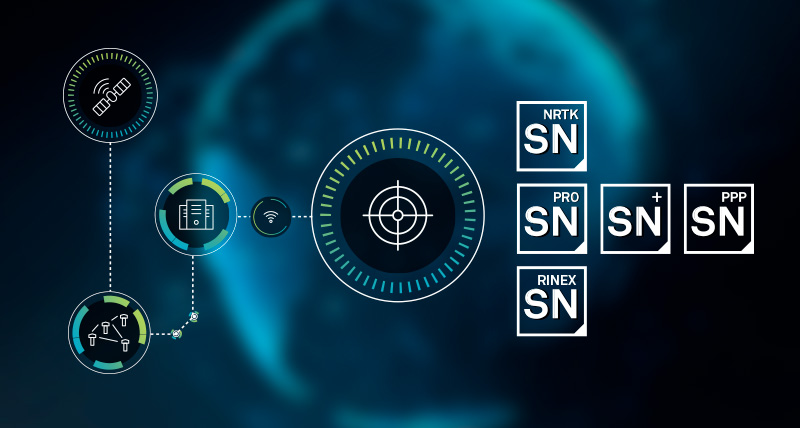
With HxGN SmartNet, Hexagon has built a reliable, scalable GNSS infrastructure that integrates physical reference stations, specialized software such as Leica Spider, and a secure environment for distributing precise positioning data. Supporting tens of thousands of users worldwide, SmartNet delivers the accuracy and continuity essential for daily operations across many sectors.
The MMoU signatories hope to advance resilient positioning services and strengthen geospatial capabilities for nations around the world. Through joint initiatives, they aim to:
Enhance continuity and accuracy of GNSS-based positioning services
Strengthen resilience against signal interference
Support countries in developing and maintaining geodetic infrastructure
Expand education and workforce development in geodesy.
These initiatives ultimately help end users access more consistent accuracy, higher service availability, and stronger resilience against jamming or spoofing.
The MMoU was signed by Henning Sandfort, president, Geosystems Business Area, Hexagon, and Dieter Fritsch, Hexagon’s representative to the UN-GGIM Private Sector Network, on Nov. 17.
“Joining the MMoU underscores our commitment to ensuring that accurate, dependable geospatial information is accessible to governments and organisations worldwide,” Sandfort said.
“Hexagon’s contribution under the MMoU demonstrates the importance of global collaboration between Member States, UN and the geospatial industry,” said Nicholas Brown, head of Office at the UN-GGCE. “Hexagon is a key player of GNSS technology and digital reality solutions and therefore mostly welcomed to contribute the future vision of a strengthened global geodesy supply chain.
My May 2025GPS World newsletter highlighted the American Association for Geodetic Surveying (AAGS) “Certificate for Geodetic Surveying” Program. This newsletter will update readers on the program. As I mentioned in the May 2025 newsletter, the Certificate for Geodetic Surveying program is designed to meet the needs of surveyors and others who perform spatial analyses and computations using geodetic methods.
Some of you may not be familiar with AAGS. The American Association for Geodetic Surveying (AAGS) aims to guide the community of geodetic, surveying and land information data users into the 21st century by working together to develop new educational programs — such as presentations, seminars, and workshops on geodetic surveying — and by publishing articles and papers that share the latest scientific and technological advances, along with advice for cost-effective, efficient implementation. AAGS also encourages a deeper understanding of geodesy by offering educational materials in geodesy, geodetic surveying and related fields.
The AAGS Board meets on the second Wednesday of each month at 4:00 p.m. (Eastern Time). Please visit the AAGS website and consider joining our monthly board meetings — a forum to share ideas and learn about geospatial products and services. All are welcome. To be added to the attendee list, email me at [email protected].
Here’s the latest on the certification program: AAGS has developed questions covering the seven core areas of minimum competence in geodetic certification: (1) Geometric Geodesy, (2) Physical Geodesy, (3) Accuracy and Error, (4) Temporal Aspects, (5) Global Navigation Satellite Systems, (6) Geodetic Survey Networks, and (7) Standards and Guidelines. For details on each topic, see my May 2025 GPS World newsletter. The information below includes examples the Board is considering for the exam.
In the ECEF coordinate system, the X and Y axes define
minor axis of a reference ellipsoid
spin axis of the Earth
prime meridian and north pole
|equatorial plane
Physical Geodesy
The term ‘deflection of the vertical’ applies to what?
Error introduced when the curvature of the earth is not accounted for
The angular difference between the perpendicular to a reference ellipsoid and perpendicular to the field of gravity at a location.
The distortion induced on the Earth’s gravitational field by a large mass beneath the surface
The difference between true and geodetic North at a location.
Accuracy and Error
A __________________ is the difference between the observed value and the most probable value.
blunder
residual
standard deviation
systematic error
Temporal Aspects
What is the purpose of National Geodetic Survey’s EPP model?
To transform ITRF coordinates to NAD 83 (2011) Epoch 2010.00.
To transform ITRF coordinates to a 2022 Terrestrial Reference Frames Epoch 2020.0 (a way of describing a plate’s rotation).
To transform ITRF coordinates to WGS84 Epoch 2020.00.
Global Navigation Satellite Systems (GNSS)
The satellite ______________________ sets up an arbitrary threshold below which GPS satellites should not be measured.
azimuth
inclination angle
mask angle
zenith angle
Geodetic Survey Networks
In a GPS network adjustment, primary reason for the minimally constrained adjustment is to ensure that
a) the baseline components are free of large errors
b) the control point coordinates have no errors
c) the degree of freedom of adjustment is correct
d) integer ambiguities have been determined correctly
Standards and Guidelines
Which of the following statements about the State Plane Coordinates System (SPCS) is false?
Eliminates having individual adjacent surveys based on different assumed coordinates
Extensive highway projects can start at one control point and close on another at some distance away.
If a monument is lost, one can use other SPCS monuments to recover the lost monument.
Since SPCS utilizes a “developable surface” to project ground points onto a plane, the resulting projection is “distortion free”
The draft questions are under expert review to ensure they target the right geodetic concepts and effectively assess the knowledge needed by those creating geospatial products and services. Our aim isn’t to make everyone a geodesist, but to ensure anyone producing geospatial products understands enough geodesy to create, depict, and document them correctly. AAGS is partnering with NSPS to implement the program, aiming for a 2026 launch. I’ll share updates in future emails.
We’ve discussed producing shorter YouTube sessions focused on key concepts from the seven competency areas of the geodetic certification program. These would complement the existing member-only educational videos on the AAGS website. For details, see the Resources tab on the AAGS website.
YouTube of Real-Time GNSS Networks: RTN Alignment — User Perspective and Managing RTNs.
New 4-Part Educational Video Series on Real-Time GNSS Networks (RTNs) – RTN Alignment The American Association for Geodetic Surveying (AAGS) is pleased to share a comprehensive four-part video series focused on Real-Time GNSS Networks (RTNs) and RTN Alignment — a topic that continues to grow in importance as more agencies, universities, and private organizations operate or rely on RTNs. This series brings together academic researchers and industry practitioners to provide clear user-level guidance and practical network-management insights grounded in current research and real-world field experience. Part 1 — RTN Alignment-User Perspective: Lecture : https://lnkd.in/eMuBqRkz Chase Simpson (Assistant Professor of Practice, Oregon State University) explains RTN fundamentals, field procedures, accuracy expectations, and how to combine real-time GNSS with conventional surveying. Part 2 — RTN Alignment-User Perspective: Q&A: https://lnkd.in/e_5vcM7Y A panel discussion addressing weighting strategies, redundant observations, GEOID2022 implications, and best practices for verifying RTN accuracy in the field. Part 3 — Managing RTNs: Lecture: https://lnkd.in/eV5P-daq William Ohene (PhD Student, Oregon State University) presents new research on monitoring core station stability, detecting reference station issues, and aligning RTNs with the National Spatial Reference System (NSRS). Part 4 — Managing RTNs: Q&A: https://lnkd.in/ejpkJq2Z A follow-up discussion on operational considerations for RTN managers, network density, coordinate updates, and improving user confidence across real-time networks.
Why AAGS is sharing this series As part of our mission to support professional education and strengthen the geodetic surveying community, AAGS is committed to providing accessible, high-quality resources on emerging practices, technologies, and research.
This RTN series supports surveyors, geodesists, GIS professionals, and RTN operators who rely on accurate real-time positioning.
AAGS extends our appreciation to: • Lecturer: Chase Simpson • Lecturer: William Ohene • Moderator: Dave Zilkoski • Panel contributors: Karen Meckel, Müge Albayrak, and Brian Weave
We hope this series supports your professional practice, education initiatives, and technical development.
Please feel free to share your thoughts or questions — we welcome community discussion.
As noted, AAGS members can access educational material on the AAGS website covering geodetic topics that will help answer many exam questions. Numerous external resources are also available. For example, NOAA’s National Geodetic Survey (NGS) offers webinars, online lessons, and educational videos, and GeoLearn provides continuing education courses for surveyors.
Please visit the AAGS website and consider attending our monthly Board meetings. If you’d like to attend, want more information about AAGS, are interested in serving on a committee, or wish to collaborate on YouTube sessions about geospatial topics, email me at [email protected].
The UK Hydrographic Office (UKHO) hosted the UK’s first cross-government geodesy, positioning, navigation and timing working group in October. Representatives from 19 government bodies shared insight on the risks, opportunities and interdependencies linked to PNT systems, including GNSS.
On Nov. 19, the UK announced a £155M investment in PNT. The working group will continue to support collaboration and exchange knowledge as further resilience actions progress, according to the UKHO.
GNSS supports critical activities across the UK economy. It provides accurate location and timing for communications, maritime and aviation safety, and the smooth running of power and financial networks. As threats to space-based systems grow, improving national resilience is increasingly important.
“The UKHO’s expertise in geodesy plays a key role in helping the UK understand and protect PNT services. Our specialists provide trusted positioning and timing advice across defense and civil programs, including supporting the safety of navigation in UK waters,” the agency said.
“It is fantastic to hear that the work with eLoran, GNSS Interference Monitoring Programme, Space Based Time Transfer and the National Timing Centre have received ongoing funding,” said Joe Pearce, senior geodesy and PNT specialist, UKHO. “This funding will assist both our data collection and the mariner. It will protect and assist future geodesy and PNT, improving resilience as these systems come increasingly under threat.”
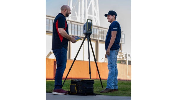
Trimble has provided advanced geospatial equipment to Fresno State’s Geomatics Engineering Program in collaboration with California Surveying & Drafting Supply, a Cansel company (CSDS). The equipment is designed to facilitate experiential learning in optical surveying, photogrammetry, GIS, GNSS and scanning workflows, helping to equip geomatics students with the skills needed for future careers. As part of this collaboration, Fresno State will open a Trimble Technology Lab on campus in 2026 as a place for students to get hands-on experience and training.
As the nation’s first four-year, nationally accredited geomatics program and California’s only Accreditation Board for Engineering and Technology-accredited four-year offering, Fresno State has long been a hub for training the geospatial professionals who power land surveying companies throughout the Western U.S., including entities like Caltrans and PG&E. CSDS, with its expertise in bridging academic needs with industry solutions, was instrumental in bringing Trimble on board to expand the program’s equipment inventory, foster innovation and ensure the program’s sustainability as a talent pipeline for California’s geospatial industry.
“This strategic alliance is key to revitalizing and aligning educational offerings with the cutting-edge tools that define the profession,” said Tom Cardenas, senior vice president at CSDS. “Beyond offering students a hands-on learning approach, this project establishes a scalable model for addressing the surveyor shortage through industry and education collaboration. It’s a clear commitment to reshaping the future of geospatial education in California.”
The Bureau of Labor Statistics reports a significant decline from 56,200 employed surveyors in the U.S. in 2010 to 47,770 in 2020. In California, where more than 2,000 surveyors depend on advanced technologies to support a booming construction and utility sector, the shortage poses a tangible threat to projects ranging from highway expansions to renewable energy installations.
“Fresno State is a critical pipeline for California’s geospatial workforce. The collaboration with CSDS and Trimble amplifies our collective mission to align educational offerings with the state-of-the-art tools that meet the demands of a rapidly evolving industry,” said Bryan Gibert, director of sales enablement at Trimble. “This collaboration is about creating an ecosystem that draws in talent and prepares them for immediate impact.”
The equipment includes Trimble GNSS base receivers, data collectors and network capabilities; Trimble S7 robotic total stations; Trimble DiNi digital levels; Trimble X9 3D laser scanners with T10x tablets; and licenses for Trimble Business Center, Trimble RealWorks and other highly technical software such as Trimble’s aerial photogrammetry module for TBC and Trimble eCognition. Trimble also outfitted Fresno State’s Geomatics Engineering program with several C5 mechanical total stations for a complete, turnkey solution. Both Trimble and CSDS provide configuration, calibration and on-site training for the technology.
“We emphasize hands-on training in our facility, complete with high-end computers, advanced distance learning tech and collaborative research projects with local agencies like CSDS,” said Scott Peterson, associate professor and program coordinator of the Geomatics Engineering Program at Fresno State. “While we had solid foundations from previous industry partnerships, we needed to expand with Trimble technologies to align our geomatics education with what the overwhelming majority of California professionals use every day. This turnkey solution, from GNSS to scanners and software, prepares our students for real-world challenges across geomatics and construction, leveraging our control network for practical training.”
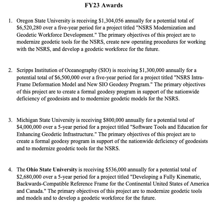
In my November 2023GPS World newsletter, I highlighted the announcement made by the National Geodetic Survey (NGS) of the recipients of the National Oceanic Atmospheric Administration (NOAA) FY 23 Geospatial Modeling Competition Awards. The primary objective of these projects is to modernize geodetic tools and models as well as develop a geodetic workforce for the future. My past two GPS World newsletters, February 2024 and March 2024, highlighted two of the grantees — Scripps Institution of Oceanography and The Ohio State University — that included developing models to address what NGS denotes as the Intra-Frame Deformation Model (IFDM). This newsletter will address another NGS geospatial modeling grant awardee, which is the proposal made by Oregon State University (OSU).
The title of the OSU proposal is “NSRS Modernization and Geodetic Workforce Development.” Christopher Parrish, Ph.D., director of the Geospatial Center for the Arctic and Pacific (GCAP), is the lead principal investigator (PI). I met him when we both worked for the NGS years ago. The goal of the OSU project is to improve the National Spatial Reference System (NSRS) and enhance workforce development and geodetic science.
I will highlight several items in the proposal, but first, I must address the issue of two universities with the same acronym, which is “OSU.” In my opinion, since The Ohio State University officially used the acronym first, it is The OSU, but Chris said we are just going to have to agree to disagree. See “Two Universities with the Same Acronym” for the facts.
There could be some confusion in my newsletters because the acronym OSU is used by The Ohio State University and Oregon State University. That said, in the remainder of this newsletter, OSU will refer to Oregon State University.
The OSU project is organized by the following three themes:
1) Development and Investigation of Geodetic Tools, Models, and Workflows.
2) Enhancement of Geodetic Infrastructure.
3) Geodetic Partnerships, Education and Outreach.
The project will develop and support a new generation of geodesists, surveyors and geospatial professionals. The plan will build on OSU’s Geomatics graduate program, the University of Alaska Anchorage (UAA) undergraduate Geomatics program, and partnerships throughout the nation to provide opportunities for both undergraduate and graduate students to directly participate in cutting-edge research. This part of the proposal will help address the geodesy crisis. As I mentioned in my March 2024 newsletter, I have been highlighting the geodesy crisis and programs that advance the science of geodesy — July 2020, November 2022, and December 2022.
The goals of the OSU proposal will be achieved through the following five objectives:
Objective 1: Develop and test novel approaches to integrate precise point positioning (PPP) and real-time networks (RTNs) into the NSRS, including the development of a real-time network (RTN) alignment service. The current focus includes:
Explore alternative methods to monitor RTN health.
Develop a semi-automatic workflow for aligning RTNs to the NSRS.
Create an accessible web-based interface to empower surveying practitioners and RTN managers with real-time network alignment information.
The proposal states: Auser-friendly real-time network alignment program will be very helpful to RTN operators during the implementation of the new, modernized NSRS.
Part of the proposal includes contributing to the development and evaluation of NGS’s OPUS Projects web tool for the inclusion of multi-GNSS, gravity, leveling and total station observations.
The inclusion of additional types of data into OPUS Projects will allow users to incorporate all survey data from their projects into the new, modernized NSRS such as leveling data to estimate NAPGD2022 orthometric heights.
Objective 2: Create standard operating procedures (SOPs) to ensure proper implementation of and transition to the new 2022 datums for geospatial applications such as topographic mapping, photogrammetric surveys and asset inventories.
Developing standard operating procedures will provide consistency between different surveying and mapping agencies, as well as routines developed by software companies during the implementation phase of the new, modernized NSRS.
The OSU proposal includes developing automated methods to manage the Oregon Real-Time GNSS Network (ORGN) to improve the ability of users to observe real-time coordinates in the new, modernized NSRS.
This work is very important to all RTN operators. It will lead to the development of a National Real-Time Network (RTN) alignment service that will allow RTN operators/managers to align their RTN with the new, modernized NSRS.
Objective 3: Improve the Columbia River Inter-Tribal Fish Commission’s, and the Yurok Tribe’s hydrodynamic models of the Columbia and Klamath Rivers through use of the modernized NSRS.
This may seem like a very local benefit, which it obviously is, but the RTN improvements enabled through their other tasks will support efficient, accurate bathymetry collection at greatly reduced cost and will extend training into a broader community of users. NAPGD2022 and GEOID2022 will improve the use of the data for hydrodynamic modeling throughout the nation. Therefore, these enhancements will enable improvement in the modeling of water levels in other water systems and in the accurate representation of dynamics of shallow water habitat. This is a benefit that will be useful to many NSRS users.
Objective 4: Assist in the development and testing of OPUS-Projects and M-PAGES. As previously mentioned, part of the proposal includes contributing to the development and evaluation of OPUS Projects for the inclusion of multi-GNSS.
This is important because incorporating multiple satellite systems, such as GPS, GLONASS, Galileo and BeiDou, into the processing routine will improve the precision and accuracy of coordinates, especially in the height component.
Objective 5: Develop and train the next generation of geodesists, surveyors and geospatial professionals and broaden participation in these fields through existing and new collaborative programs between the tribal, academic and government members of the Geospatial Center for the Artic and Pacific (GCAP), where education and outreach are part of its mission. GCAP provides training workshops covering topics such as GNSS, geodesy, 3D laser scanning and least squares adjustments.
These types of workshops are usually locally given but part of the proposal includes working with Oregon State E-campus to expand the workshops to an online education program. This will benefit a lot of surveyors, mappers, and geospatial users across the Nation.
These five objectives will be achieved through eight focused tasks organized into the three themes previously mentioned. The new, modernized NSRS will affect in some way the daily operations of all geospatial users. I have highlighted several tasks that, in my opinion, are critical to the implementation of the new, modernized NSRS. For example, incorporating all types of geodetic data into OPUS Projects will help facilitate the implementation of the new NSRS; developing a National RTN Alignment Service will allow RTN operators/managers to align their RTN properly and correctly with the new, modernized NSRS; and working with Oregon State E-campus to expand the workshops to an online education program will increase outreach efforts that will benefit many users across the geospatial community.
Key benefits:
Enhancing and extending diverse use of the NSRS where these advances are most needed.
CORS postprocessing with PPP will facilitate both CORS monitoring and position.
Providing impactful and critical workforce development such as new career opportunities for future generations by expanding undergraduate and geomatics education opportunities and capacity as well as career advancement and upskilling opportunities for the existing workforce.
New outreach programs will actively engage Alaska Native communities and K-12 students.
Graduate and undergraduate students involved with the project will have unique interdisciplinary experiential learning opportunities collaborating with professionals.
Providing broader impacts to society and the planet, including improved resilience to coastal and seismic hazards with improved monitoring capabilities, and developing a diverse geodetic science and geomatics workforce in a currently underserved region.
This newsletter and my past two GPS World newsletters highlighted three of the NGS Geospatial Modeling grantees, Scripps Institution of Oceanography, The OSU, and OSU, which included creating geodesy curriculums that will help address the geodesy crisis. Changes in these geomatic programs will provide students with the skills in geospatial systems that will make available opportunities for employment in the public and private sectors. My next newsletter will address the fourth NGS geospatial modeling grant awardee: Michigan State University’s proposal.
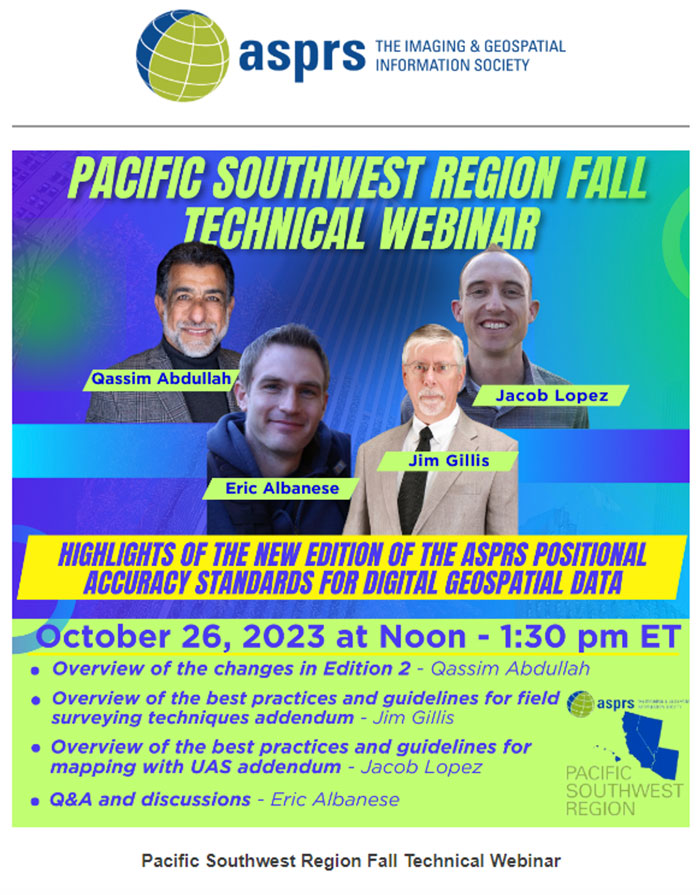
On Oct. 26, 2023, I participated in an American Society for Photogrammetry and Remote Sensing (ASPRS) Pacific Southwest Region Fall Technical webinar. The webinar provided an overview of the ASPRS Positional Accuracy Standards for Digital Geospatial Data (Edition 2, Version 1.0 – August 2023). The document can be downloaded here.
ASPRS Webinar Announcement. (Image: ASPRS)
I also participated — virtually — in the Nov. 2, 2023, California Spatial Reference Center (CSRC) Coordinating Council fall meeting where Dr. Riadh Munjy, California State University, Fresno, discussed the revisions to the ASPRS Positional Accuracy Standards for Geospatial Data.
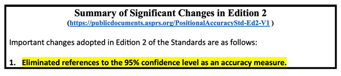
The most significant changes introduced in this second edition of the standards include:
Elimination of references to the 95% confidence level as an accuracy measure.
Relaxation of the accuracy requirement for ground control and checkpoints.
Consideration of survey checkpoint accuracy when computing final product accuracy.
Removal of the pass/fail requirement for Vegetated Vertical Accuracy (VVA) for lidar data.
Increase the minimum number of checkpoints required for product accuracy assessment from 20 to 30.
Limiting the maximum number of checkpoints for large projects to 120.
Introduction of a new term: three-dimensional positional accuracy.
Addition of Best Practices and Guidelines Addenda for:
General Best Practices and Guidelines
Field Surveying of Ground Control and Checkpoints
Mapping with Photogrammetry
Mapping with Lidar
Mapping with UAS
As outlined above, Edition 2 contains Best Practices and Guidelines for (1) General Best Practices and Guidelines and (2) Field Surveying of Ground Control and Checkpoints. The three addenda listed in the table of contents: Mapping with Photogrammetry, Mapping with Lidar, and Mapping with UAS will be available for public comment later, and will be added to Edition 2, Version 2.0.
Dr. Abdullah informed me that these addenda are on track to be put out for public comments during December 2023, therefore he believes they will probably be published in January or February 2024. The box titled “Summary of Significant Changes in Edition 2” provides the changes with the reason and justification for each change. The document can be downloaded from ASPRS here.
One of the changes is to relax the accuracy requirement for ground control and checkpoints. At first glance, this seems like the wrong thing to do. However, after understanding the justification, the requirement for ground truth still needs to be at least twice as accurate as the product.
Both Dr. Abdullah and Dr. Munjy’s emphasized in their presentations that the current accuracy requirements for ground controls in photogrammetric work of four-times better than the produced products, and the checkpoint accuracy requirement is three-times better than the assessed product. This makes it difficult, if it is not impossible, to use RTK-based techniques for this type of surveying. This by itself is not the reason for the change. During Dr. Abdullah’s presentation, he provided the following reasons for the change:
“Experience taught us that the requirements of four-times and three-times adopted in edition 1 of the standards are excessive and too restrictive, partly due to the reason outlined in (b) below.
Today’s sensors, software, and processing methodology are more accurate and the room for errors in the product is diminishing, therefore we do not need a safety factor of 3 or 4 to obtain accurate products.
Increasing demand for higher accuracy geospatial products.”
The new standards now factor in the accuracy of the survey checkpoints when determining the accuracy of the product. During Dr. Abdullah’s presentation, he provided the following reason for the change, “As we are producing more accurate products, errors in surveying techniques of the checkpoints used to assess product accuracy, although small, can no longer be neglected and it should be represented in computing the product accuracy.” He also highlighted that, “As product accuracy increases, the impact of error in checkpoints on the computed product accuracy increases.” The document provides equations used to compute the values. See below.
A very significant change, in my opinion, is the removal of the standards for Vegetated Vertical Accuracy (VVA) for lidar data. See below.
VVA not used as a criterion for acceptance. (Image: ASPRS)
I am not sure I agree with the reasoning, but I understand why it was done. GNSS-based surveys do not perform well in vegetated areas, and this is the technology used to validate the non-vegetated vertical accuracies (NVA). That said, there are non-GNSS technologies — sometimes denoted as traditional surveying methods — that could be used to validate VVA, so this seems like an elimination of a requirement based on the limitation of a particular technology.
Traditional surveying methods that use geodetic levels, theodolites, and total stations to measure distances, angles, and heights are still used by surveyors to perform certain projects. Since there are other surveying methods that could be used for evaluating the VVA, it does not seem like a valid reason for a change.
The ASPRS standards does state that, “for projects where vegetated terrain is dominant, the data producer and the client may agree on an acceptable threshold for the VVA.” Therefore, the client can require the surveyor to meet a specific accuracy level for vegetated areas. I am sure this was discussed during the working meeting, so I leave it to the experts to make the appropriate decisions and recommendations.
Finally, it should be noted that, as discussed above, the new ASPRS standards eliminated the reference to the 95% confidence level as an accuracy measure. The document provides the following statement about the National Standard for Spatial Data Accuracy (NSSDA):
“The National Standard for Spatial Data Accuracy (NSSDA) documents the equations for the computation of RMSEX, RMSEY, RMSER and RMSEZ, as well as horizontal (radial) and vertical accuracies at the 95% confidence levels — AccuracyR and AccuracyZ, respectively. These statistics assume that errors approximate a normal error distribution and that the mean error is small relative to the target accuracy. The ASPRS Positional Accuracy Standards for Digital Geospatial Data reporting methodology is based on RMSE alone, and thus differs from the NSSDA reporting methodology. Additionally, these Standards include error inherited from ground control and checkpoints in the computed final product accuracy.”
Appendix D of the ASPRS document provides the equations with an example for computing the accuracy statistics. The document also has a section with examples for users who wish to relate the ASPRS 2023 Standards to the FGDC National Standard for Spatial Data Accuracy (NSSDA).
Dr. Munjy ended his presentation at the CSRS 2023 fall meeting with the following statements:
“ASPRS Accuracy Standards 2023 have become more aligned with science and statistical theory,” and “These Standards are intended to be a living document which can be updated in future editions to reflect changing technologies and user needs.”
I would encourage all users to download the document to better understand the changes and reasons for the changes. It can be downloaded here.
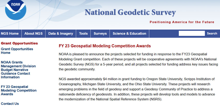
In my last column, I highlighted the announcement made by the National Geodetic Survey (NGS) of the recipients of the NOAA FY 23 Geospatial Modeling Competition Awards. As shown in the image below, NGS awarded approximately $4 million in grant funding to four institutions for projects that will research emerging problems in the field of geodesy, develop tools and models to advance the modernization of the National Spatial Reference System (NSRS), and help address a nationwide deficiency of geodesists.
Image: NGS
I had the opportunity to speak with Juliana Blackwell, director of the NGS, about the geospatial awards. I asked her how the grants will help NGS in its development of products and services as well as the implementation of the modernized NSRS.
“The geospatial modeling grant is an opportunity to expand our abilities within NGS to address research challenges, diversify the tools we provide, and multiply our future workforce,” Blackwell said. “I’m excited about the competitive and collaborative nature of the grant and the chance for NGS to work with a variety of academic institutions.”
NGS awarded the grant funding to four institutions including Oregon State University, Scripps Institute of Oceanography, Michigan State University, and the Ohio State University. Looking at the summary of the awards, there appears to be some overlapping interest between grantees that could lead to a diverse set of solutions to a problem or task. I will report on specific tasks and outcomes as more details become available.
I was pleased to see that grant proposals included developing new geodetic tools and operating procedures for working with the new, modernized NSRS. Hopefully, these universities will engage the geospatial user community when developing new tools so the tools will be useful during the implementation of the new NSRS.
Summary of the Geospatial Awards (Image: NGS)
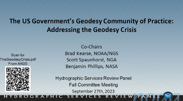
Besides providing funds for the geospatial grants, NGS is collaborating with other federal agencies to address the geodesy crisis. This collaboration, denoted as the “Geodesy Community of Practice (COP),” includes four agencies — NGS, National Geospatial-Intelligence Agency (NGA), National Aeronautics and Space Administration (NASA), and United States Geological Survey (USGS). The co-chairs of the group discussed the group’s actions and goals at the Hydrographic Services Review Panel (HSRP) fall committee meeting held in Silver Spring, Maryland, on Sept. 27-29.
Geodesy Community of Practice. (Image: NOAA’s Hydrographic Services Review Panel)
The HSRP involves four NOAA offices: three National Ocean Service (NOS) program offices -NGS, the Center for Operational Oceanographic Products and Services (CO-OPS), the Office of Coast Survey (CS), and the University of New Hampshire’s Joint Hydrographic Center and Center for Coastal and Ocean Mapping. More information and the presentations from the HSRP meeting can be obtained here. The purpose of the committee is to review and provide NOAA with independent advice on their products and services.
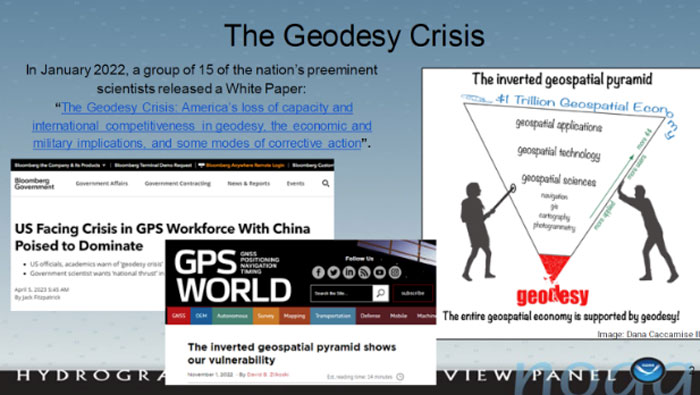
I attended the three-day HRSP meeting as a virtual participant. As previously noted, NGS is one of the NOS offices that’s part of the HSRP. As the Director of NGS, Blackwell participated in the 2023 fall HSRP meeting. A majority of the meeting discussed the geodesy crisis. In my opinion, this is due to Blackwell’s efforts to highlight the importance of geodesy to NOAA products and services.
The presentation by the co-chairs of the Geodesy Community of Practice highlighted a few articles that have brought the geodesy crisis to the attention of the geospatial user community. Anyone keeping up with my columns knows that I have been highlighting the geodesy crisis and programs that advance the science of geodesy (July 2020, November 2022, December 2022, and April 2023). The geodesy crisis white paper is posted on the American Association for Geodetic Surveying (AAGS)website.
Image: NOAA’s Hydrographic Services Review Panel)
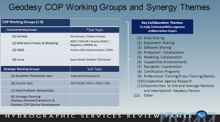
The Geodesy COP established working groups to address topics that are important to all geospatial users. All the agencies are supporting the working groups which should help create more effective and efficient solutions to technical geodetic issues.
Image: NOAA’s Hydrographic Services Review Panel
A goal of the Geodetic Community of Practice is to train future geodesists. The advancements in satellites and computers have enabled geodesy to expand into many different disciplines. Geodetic science and technology now underpin many sciences, large areas of engineering (such as driverless vehicles and UAVs), navigation, precision agriculture, smart cities, and location-based services.Major U.S. companies, such as Google and FedEx, as well as the automobile industry, precision farming companies and mining companies also need more accurate geodetic models, tools, and algorithms.Therefore, these companies also need trained geodesists to perform important research on topics that address their specific geodetic requirements.I highlighted this in my July 20, 2020, GPS World First Fix article.To address the geodesy tradecraft, the COP includes providing professional government assignments.That said, many industries that rely on accurate and consistent geodetic information should also provide professional geodetic assignments.
Training future geodesists. (Image: NOAA’s Hydrographic Services Review Panel)
I asked Blackwell how she thought the U.S. government’s Geodesy Community of Practice will help NGS and the geodesy crisis.
“The Geodesy Community of Practice is in the beginning phase right now with the collaboration among federal agencies with geodetic missions, NOAA/NGS, NGA, NASA, and USGS,” Blackwell said. “There is already a benefit in sharing research, workforce, and operational needs and leveraging our resources. I envision expanded engagement with academia, private industry, and other government agencies as the community of practice matures.”
In my opinion, the Geodesy Community of Practice’s integrated working groups consisting of individuals with different backgrounds and skills addressing geospatial problems will help to advance the field of geodesy. I believe that integrated and collaborative organizations create the best geospatial solutions; the Geodesy COP is an embodiment of this concept.
Of course, as I have stated in many of my columns, I like to remind everyone that “geodesy is the foundation for all geospatial products and services.”
Anyone keeping up with my columns may know that I have been highlighting the geodesy crisis and programs that advance the science of geodesy (July 2020, November 2022, December 2022, and March 2023). On June 13-15, I had the privilege of participating in a working group event convened by the Geomatics Emerging Scientist Consortium for Education, Research and Capabilities Enhancement (GEO-ESCON). The GEO-ESCON, established in the summer of 2022, is a multi-university consortium serving the need of the Office of Geomatics of the National Geospatial-Intelligence Agency (NGA) for personnel with advanced geomatics expertise, a sustainable pipeline of critical geomatics skillsets, and capabilities enhancement in geomatics and other applied sciences. The 15-member consortium is led by The Ohio State University (OSU), which serves as GEO-ESCON’s managing higher education partner.
GEO-ESCON is part of OSU’s Battelle Center for Science, Engineering and Public Policy in the John Glenn College of Public Affairs. As stated in an OSU press release, OSU was selected for its role with GEO-ESCON because of its longstanding commitment to geodetic education — its collegiate geodetic program is the oldest in the United States and offers undergraduate and graduate degrees in both geodetic engineering and geodetic science.
OSU is home to more than 80 researchers across six colleges who focus on core research and development aspects of geospatial science and technology, including geodesy, remote sensing, photogrammetry, GIS, positioning, navigation, and timing (PNT), computer vision, mobility, smart cities, data analytics, autonomous systems (UAS, UUS and UGV), medical imaging, and precision agriculture.
The GEO-ESCON consortium is designed to create a geographically distributed, multi-disciplinary network of universities to educate the federal geomatics workforce at advanced levels and provide opportunities for applied research and technology development. Higher education institutions are invited to participate in GEO-ESCON based on their capabilities in geomatics. As of July 18, the consortium has 15 members and two additional universities are in the process of becoming members. Click here for all GEO-ESCON member institutions.
GEO-ESCON convened the June Geomatics Challenge Working Group to discuss pressing geomatics challenges and discuss potential solutions. The event facilitated dialogue between representatives from NGA’s Office of Geomatics and academic attendees on geomatics challenges of national priority that could result in actionable proposals to address the challenges. The working group enables representatives of GEO-ESCON member institutions to gain a deeper understanding of NGA’s geomatics priorities, build relationships with NGA leaders, collaborate with colleagues at other institutions, and provide recommendations to GEO-ESCON and the NGA. There were 47 academic participants representing 14 universities.
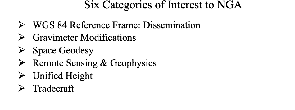
NGA aims to encourage institutions with varied expertise to propose solutions that achieve greater outcomes through collaborative work. The agency provided six broad categories of geomatics challenges for discussion. See the image below for the categories of interest.
Proposals submitted in response to the June Geomatics Challenges Request for Proposals (RFP) will be eligible for funding consideration and selected activities are expected to be awarded before the fall semester.
The word “tradecraft” in the categories of interest was intriguing. In general, tradecraft refers to the skills, techniques, and practices used by professionals in various fields to carry out their work effectively and discreetly. During World War II, however, the term became associated with spy work and now is mostly used to refer to the techniques and procedures of espionage. NGA is concerned with the dramatic drop in the number of individuals pursuing careers in geodesy — that is, the geodesy crisis in the United States.
Event attendees were asked to prioritize the topic(s) that most interested them, so that they could join a small group on the topic to identify issues, and discuss approaches, solutions, and potential actions for the challenge. Several universities had multiple representatives, so they selected different topics aligned with their individual interest.
The meeting had professional workshop facilitators, technical advisors, NGA subject matter experts (SME), and student recorders. Facilitators encouraged the full participation of all attendees to elicit a range of viewpoints and generate previously unconsidered solutions that could bridge differences in approach — resulting in solutions that were supported by many.
The small groups aligned with a specific challenge utilized the expertise of technical advisors — experts in geomatics or related fields with considerable industry, government, and/or research experience — who supported the development and maturation of proposed Geomatics Challenge solutions. The role of technical advisors was to work with the other leaders in their small group to encourage the full participation of all attendees and mentor the groups toward the generation of novel solutions. I was a technical advisor for the “unified height” topic.
NGA’s SME participated in the working group activities and provided additional context for the individual topics, and other unclassified details related to the Geomatics Challenges.
To capture the discussions at the group meetings, student recorders took detailed notes during the small group discussions. The recorders were graduate students — primarily in geodesy or other STEM fields — and they did an excellent job of capturing the discussion, action items, and potential proposals.
As previously stated, individuals self-selected the topic that interested them but over the course of the three-day meeting individuals were asked to participate in other Geomatics Challenge small groups to provide constructive critiques to produce the best research projects. This was an excellent concept that, in my opinion, helped to improve draft proposals and identify new collaborative projects.
As an example, the need for a unified height system that defines, assesses and correlates all height measurement processes became very evident when individuals participating in the “remote sensing and geophysics” topic engaged with the “unified height” topic members. This joint-topic group meeting helped form new partnerships and formulate new proposals.
The GEO-ESCON and the participating institutions have an ambitious schedule of submitting and awarding the grant proposals before the end of the government’s fiscal year. That said, the participants appeared to be up to the challenge and prepared to make it happen. For obvious reasons, I cannot describe any of the projects discussed, but I will highlight them when they become available for public distribution.
For now, I would like to state that GEO-ESCON is a great program, and it supports the advancement of the science of geodesy and geomatics. I believe that integrated and collaborative organizations are necessary for the successful development of geospatial products and services, and GEO-ESCON is the epitome of this concept. If you believe your institution would benefit from joining this consortium, I encourage you to visit their website to learn more or reach out directly to GEO-ESCON’s team ([email protected]). Click here to subscribe and stay up to date on GEO-ESCON news.
In conclusion, as in my previous column, I would like to remind everyone that geodesy is the foundation for all geospatial products and services.
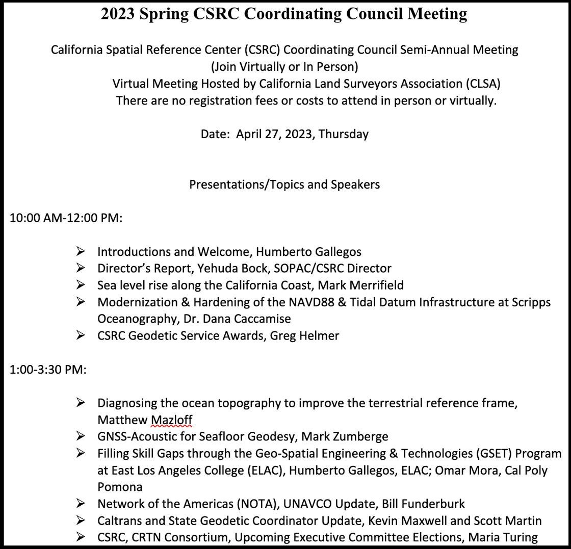
On April 27, I attended (virtually) the spring 2023 meeting of the California Spatial Reference Center (CSRC) coordinating council. See the agenda below. This column will highlight some activities with which the CSRS is involved and how it’s advancing the science of geodesy. Anyone who has been following my latest columns knows that I am an advocate for any person or organization that promotes the advancement of geodesy and recognizes that the United States is experiencing a geodetic crisis.
First, I would like to state that Yehuda Bock, the director of CSRS, has been instrumental in advancing accurate geodetic positioning for as long as I have known him. I first met Bock in 1978 while I was attending the Ohio State University.
A video of the meeting is available from the CSRC here.
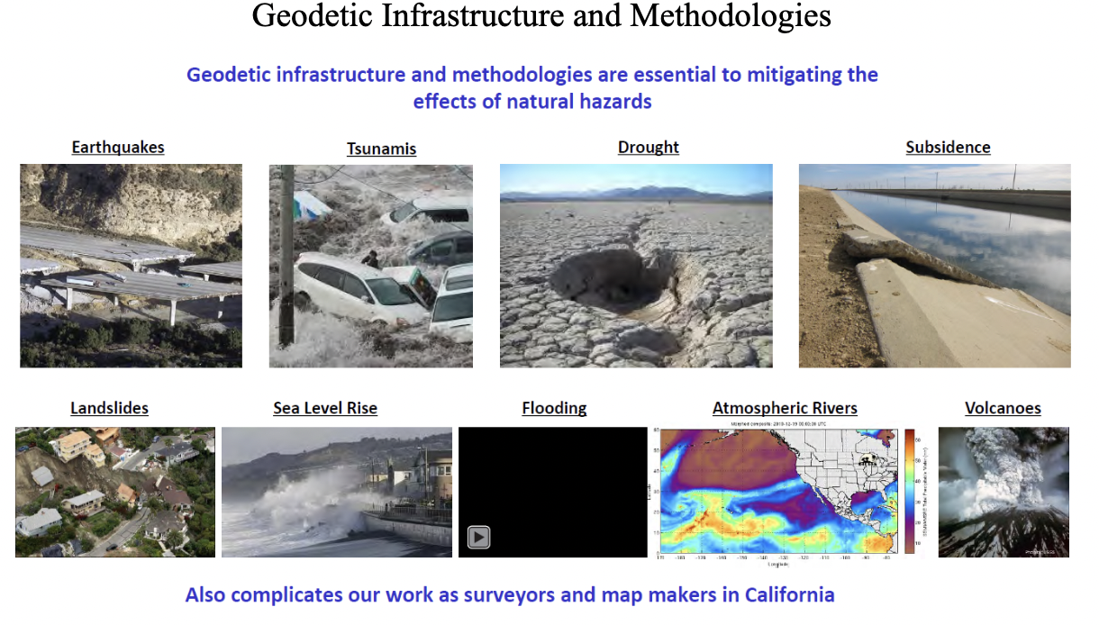
During the meeting, Bock presented the director’s report. He started with mentioning how geodetic infrastructure and methodologies are essential to mitigating the effects of natural hazards. That is something that affects everyone in the world, especially California, and one of the reasons that I always end my email messages and presentations with the following statement: “Geodesy is the foundation for all geospatial products and services.”
Geodetic infrastructure and methodologies. (Image: Yehuda Bock, Scripps Institution of Oceanography)
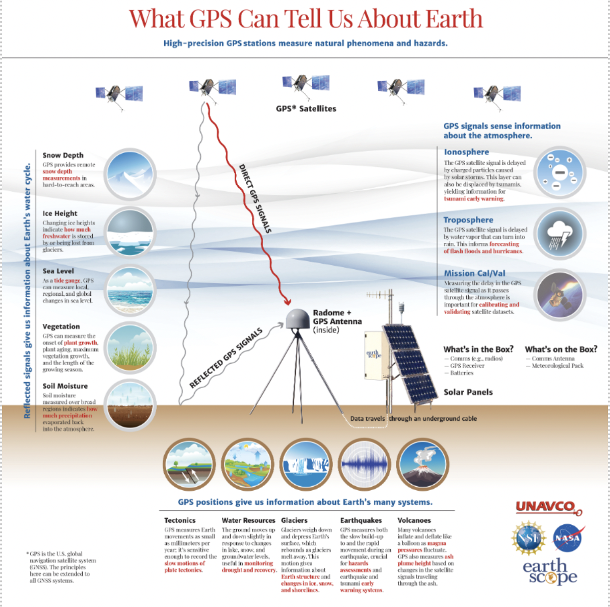
Bock highlighted how GNSS is important to explaining natural phenomena and hazards of the Earth. Most individuals use GNSS to know where they are on a map on a phone, but GNSS (and geodesy) is so much more important to the average citizen than just knowing their location on Earth. As you can see from the image below, GNSS positioning provides information about many of Earth’s systems, such as changes in local mean sea level, the values of atmospheric parameters, the status of water resources, and the movement of the Earth’s surface due to tectonic plates, glaciers, earthquakes and volcanoes. One or more of these activities are important to every individual in the world.
(Image: Yehuda Bock, Scripps Institution of Oceanography)
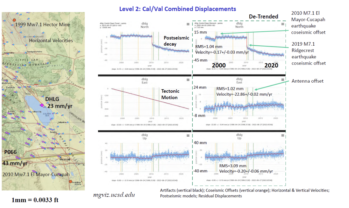
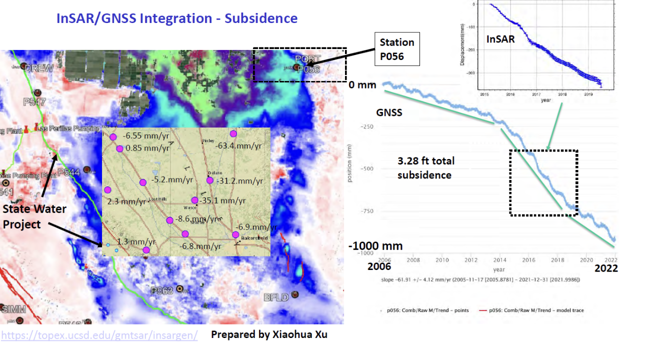
Bockprovided examples of how GNSS has been used to investigate and monitor earthquakes, which is extremely important in California. See the image below.
Displacement due to earthquakes. (Image: Yehuda Bock, Scripps Institution of Oceanography)
He highlighted a methodology of a kinematic datum that uses an intra-frame velocity model to estimate positions at any location and at anytime with respect to a reference frame and epoch.This concept is part of the National Geodetic Survey’s new, modernized, National Spatial Reference System (NSRS). Several of my previouscolumns have discussed NGS’NSRS and time-dependent coordinates (for example, see my August 2022column).
(Image: Yehuda Bock, Scripps Institution of Oceanography)
California’s geodetic network is significantly affected by crustal movement. To help address this issue, the CSRS updated the NAD 83 coordinates. It’s denoted as CSRS epoch 2017.5 (NAD 83). See the image below for the project report on the update. This is important to anyone surveying in California because of the crustal movement affecting the coordinates of the monuments. California is well positioned to implement NGS’ NSRS. Part of the implementation of the CSRC epoch 2017.50 (NAD 83) was to have the new epoch-date coordinates transmitted with RTCM 3.0 data streams. This is something that other RTN operators from around the nation will have to do after NGS publishes the NSRS coordinates. The CSRS is a model from which others can learn.
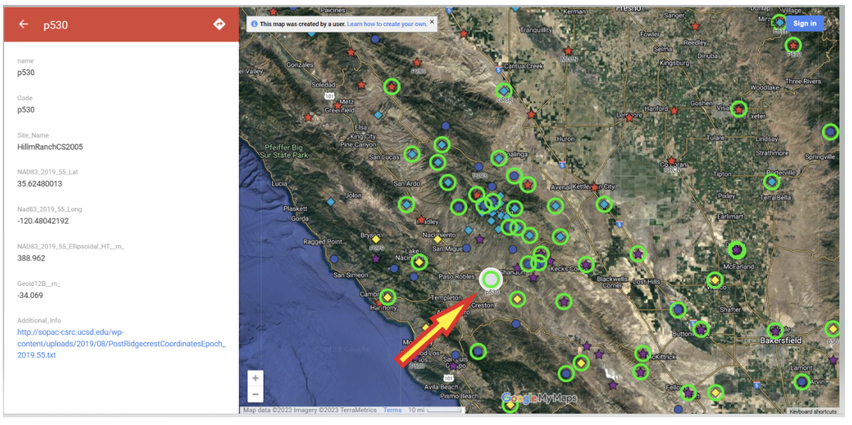
Users that access CSRC’sepoch 2017.50 website, can find thecoordinates of marks published in CSRC epoch 2017.50 (NAD83). See the image below for an example.
Mark p530 in CSRC epoch 2017.50 (NAD83). (Image: CSRC Website)
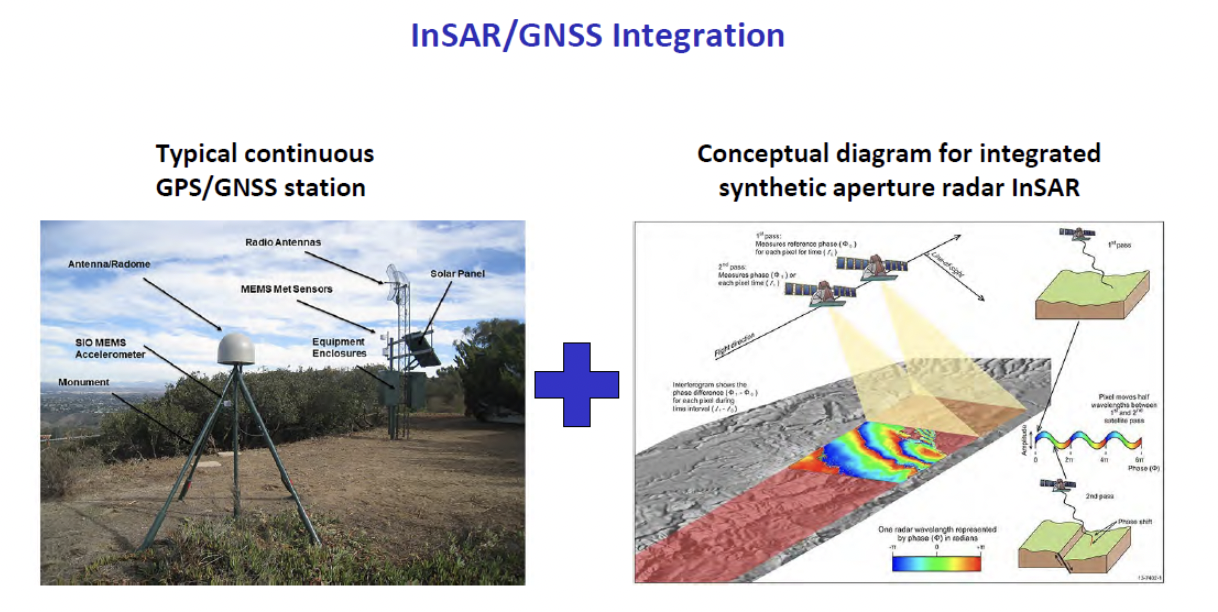
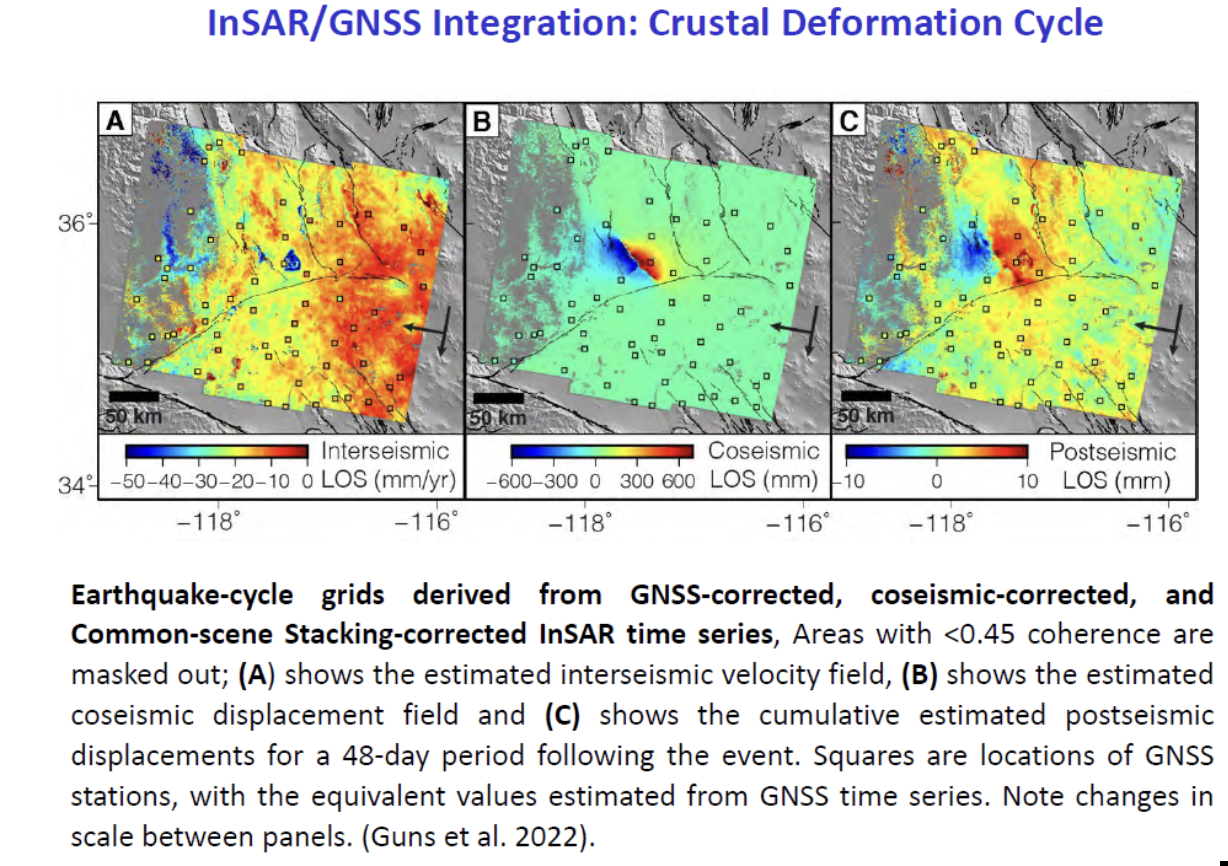
Bockdiscussed the integration of InSAR and GNSS to estimate accurateland changes over large areal extents. This type of research can help in developingan accurateintra–frame deformation model (IFDM) to account for movement between survey epoch coordinates (SEC) and reference epoch coordinates (REC). See my August 2022column for more on NGS’s definition of SEC and REC coordinates.
(Image: Yehuda Bock, Scripps Institution of Oceanography)
(Image: Yehuda Bock, Scripps Institution of Oceanography)
(Image: Yehuda Bock, Scripps Institution of Oceanography)
The rest of the director’s report included the following topics:
reference surfaces for unified reference frame
observation systems: terrestrial and marine geoids
unified reference frame
GNSS-IR
airborne gravity
geoid model
machine l;earning
tracking atmospheric rivers with GNSS meteorology
tracking extreme weather events with GNSS meteorology
cluster analysis to unsupervised analysis of GNSS time series isolate geophysical effects
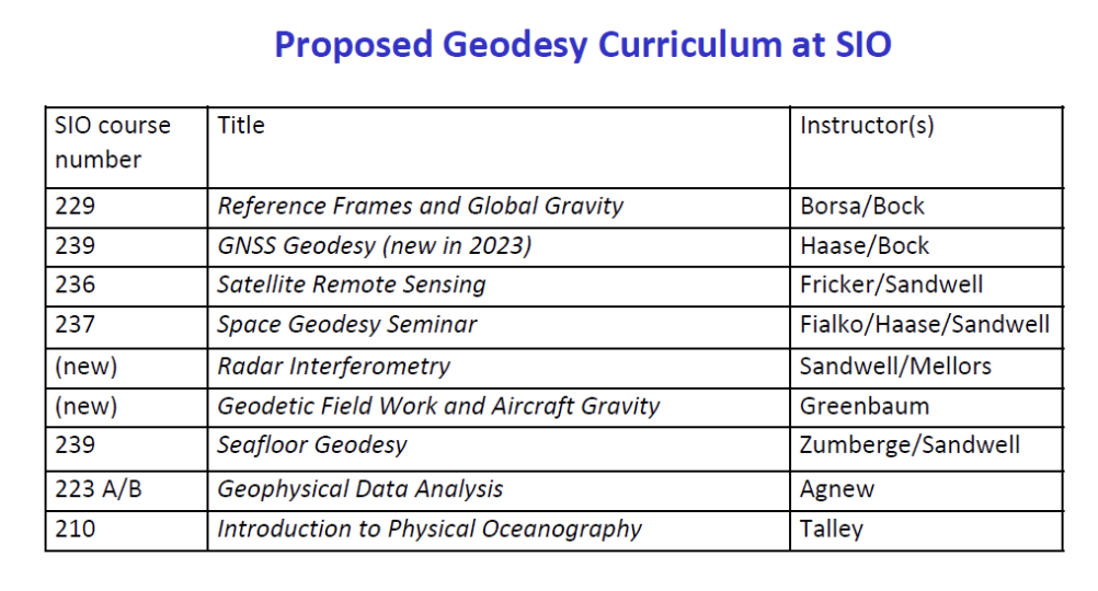
proposed geodesy curriculum at SIO.
The last one was the most important one to me because developing educational curriculums that include geodetic topics will help advance the science of geodesy.
(Image: Yehuda Bock, Scripps Institution of Oceanography)
Other speakers at the coordinating council meeting discussed the use of geodetic science in projects such as measuring sea level rise along the California coast as well as performing geodesy on the seafloor.
There was an interesting presentation by Humberto Gallegos discussing how to fill the skill gaps through the Geo-Spatial Engineering and Technologies (GSET) program at East Los Angeles College (ELAC). This program is helpful in developing future surveyors and geodesists.
(Image: EarthScope)
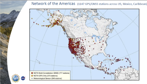
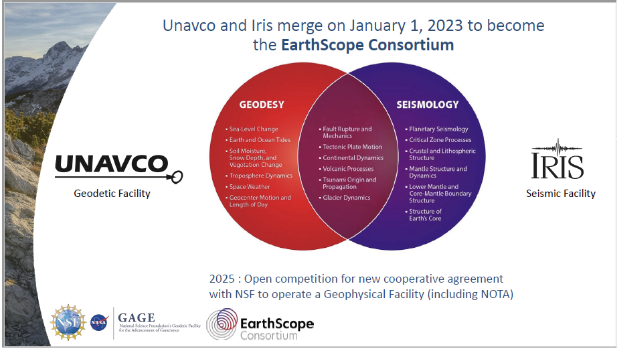
There also was a presentation on EarthScope by Bill Funderburk. See below for a few slides from Bill’s presentation. The presentation discussed the update on the Network of the Americas (NOTA). Bill provided information on NOTA partners, NOTA network and data, NOTA in California, and the EarthScope merger. His presentation also highlighted the many partners that support the NOTA, which includes 1,147 GPS/GNSS stations across the United States, Mexico and the Caribbean. Many individuals may not know it, but UNAVCO and IRIS merged on January 1, to become the EarthScope Consortium. Readers can find more information on this new organization here.
(Image: EarthScope)
(Image: EarthScope)
I only highlighted a few items from the meeting. Please see the video of the meeting for more details.
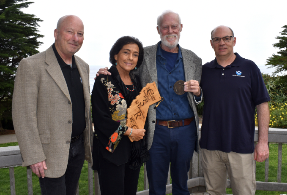
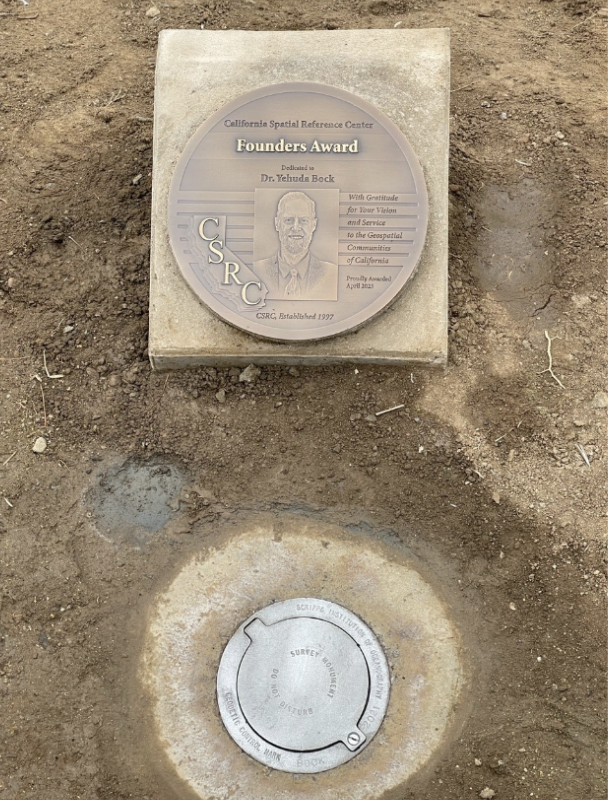
During the meeting, Bock was also presented with the CSRC Founders Award. It was a great honor for me to say a few words recognizing the important contributions that Bock has made to the geodetic community over the past five decades. It is in large part due to his leadership that California has progressed so much in geospatial positioning services. The following are a few photos from the ceremony and a statement from the CSRS.
Recognition Statement from the California Spatial Reference Center
“Distinguished Research Scientist, Yehuda Bock, was recognized by the California Spatial Reference Center (CSRC: http://sopac-csrc.ucsd.edu/index.php/csrc/) with the Founders Day Award. Presented by Dana Caccamise, Bock was honored for the “thriving science and community outreach facilitated through [his] vision and implementation of the Center for decades.” With Bock’s guidance, CSRC was established in 1997 as a partnership with surveyors, engineers, GIS professionals, the National Geodetic Survey (NGS), the California Department of Transportation (Caltrans), and the geodetic and geophysical communities, and has become of IGPP’s most successful outreach efforts.”
From left to right: Gregory Helmer, Sharona Benami, Yehuda Bock, Dana J Caccamise II (Image: Karissa Duran, Scripps Institution of Oceanography)
The dedicated plaque and monument. (Image: Karissa Duran, Scripps Institution of Oceanography)
In my opinion, integrated and collaborative organizations are necessary for the successful development of geospatial products and services.
I would like to highlight how the Ohio State University is integrating geodesy in a geology program. The Ohio State University Geology Field Camp is a geology class that is held every year. This year, the OSU Geodetic Department is going to participate in the program to explain how the science of geodesy is helpful to geologists. The plan is to provide exercises to explain how the camp’s activities can be enhanced with geodetic techniques.
The 2023 geology summer field course lasts six weeks. This year, the course starts on Thursday, June 1, and ends on Friday, July 14. Students receive six semester credit hours for completion of the course.
The course emphasize the following:
observation of stratigraphic units and their characteristics
interpretation and synthesis of structures, paleoenvironments, and geologic history
presentation of results by means of geologic maps and cross-sections
experience with 3D visualization, GIS, GPS and computer analysis of field data
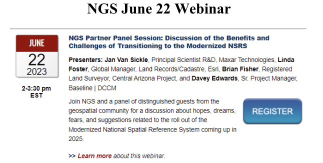
In conclusion, on June 22, NGS is hosting a webinar that will discuss some of the benefits and challenges of transitioning to the modernized NSRS. The presenters are not NGS employees. They are guest speakers from the geospatial community. I would encourage all users to register for this webinar.
On March 20, 2023, I wrote a short announcement about a funding opportunity by the National Geodetic Survey (NGS) to support the science of geodesy.
As mentioned in previous columns, Everett Hinkley wrote about the geodesy crisis in an ION article. Hinkley’s article summarized several action items that could help improve the lack of trained geodesists in the United States. One action was to encourage U.S. government support in the form of grants, professional development of staff, and research collaborations/affiliations. A pilot PhD geodesy educational program with three National Geospatial-Intelligence Agency (NGA) and one NGS employee is in place. He stated that the NGA expects to continue growing this program. Click here for more information on NGA’s academic research program.
NGS’ geospatial modeling grant is another example of this action item. There needs to be more funds added to this task, but it is a start. The program priorities under NGS’ grant program include: research and develop new methodologies for defining and applications for working with the NSRS; develop and evaluate tools, models, and guidelines to access, analyze, and manipulate geodetic data; enhance infrastructure of geodetic control, coastal remote sensing data, survey measurements, and other physical datasets that comprise the NSRS; support education, capacity building, and technology transfer for the future of geodesy; coordinate through partnerships with local, state, and regional users such as state and local governments, universities, and/or the public sector.
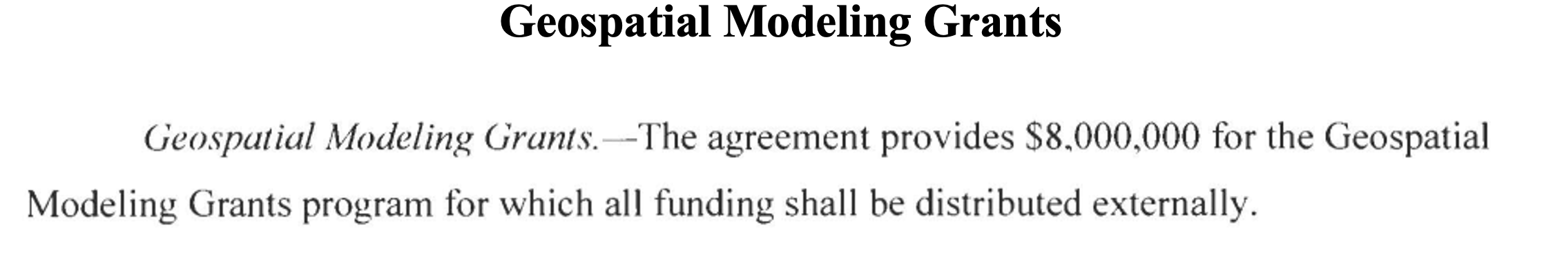
The geospatial modeling grant was included in the 2023 Omnibus Appropriations Bill. The agreement provides $8,000,000 for the program and states that all funding shall be distributed externally. Hopefully, the same amount or more will be in FY 24 appropriations. Additional information about NOAA’s appropriations can be found in the 2023 Omnibus Appropriation Bill under the explanatory statement for Commerce, Justice, Science and related agencies. The bill can be found here. To find the language in the bill click here, then search the document for “geospatial.” See the image below for the language in the bill.
Image: Senate.gov website
For those that are interested in the appropriation process, the image below provides a list of the senators that work on these agencies’ appropriations. If you are interested in learning more about the appropriation process and the geospatial modeling grants, contact your senator. The more congressional representatives know about the geodesy crisis — which includes the lack of trained geodesist as well as surveyors — the sooner they will support funds to help correct the problem. Click here for a list of senators on the Commerce, Justice, Science and Related Agencies Appropriation Committee.
Advancing geodesy with conferences
Another activity that promotes the advancement of geodesy and surveying are national and international surveying and mapping conferences. Before the American Congress on Surveying and Mapping (ACSM) disbanded, the four-member organization collaborated to convene annual surveying and mapping conferences in the United States. Topics like those presented at a FIG Working Week were presented at these conferences.
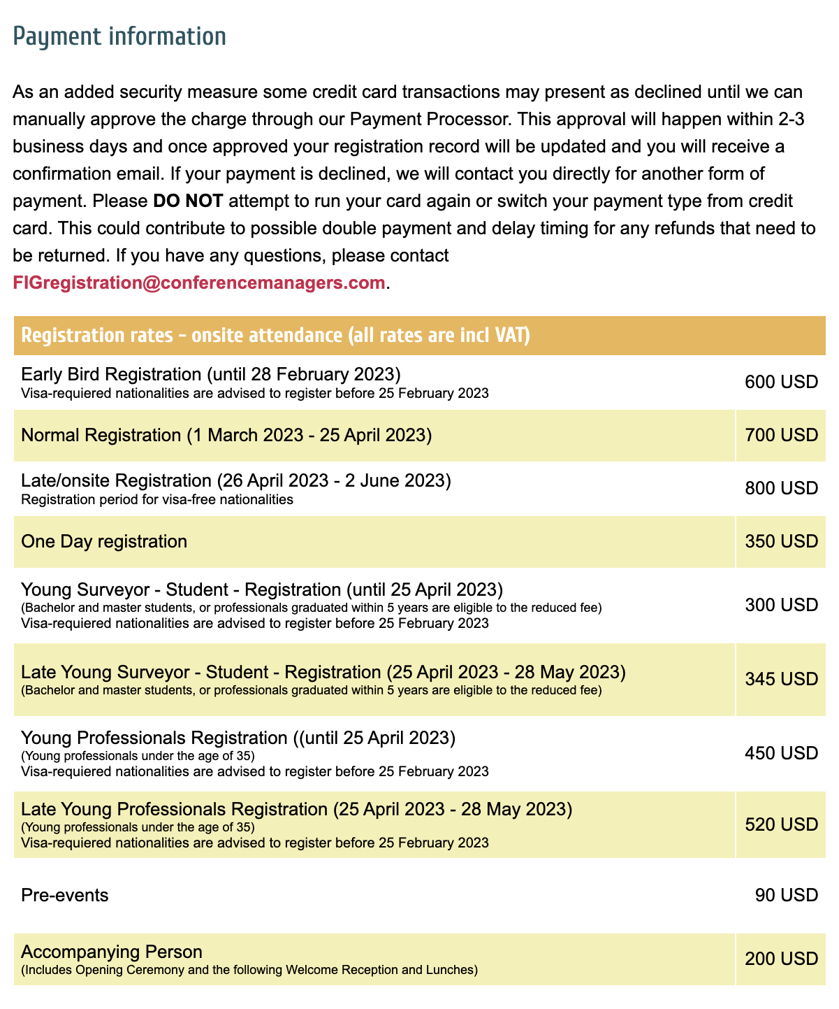
Since these ACSM conferences are no longer being held, I encourage users of geospatial data and GNSS technology to attend conferences like FIG Working Week 2023. I have participated in several FIG meetings and learned a lot from presentations as well as holding hallway meetings with experts from the international surveying and mapping community. In the March column, I highlighted that FIG Working Week 2023 is going to be held in Orlando, Florida, on May 28 – June 1. NGS will be presenting a full-day worth of content on NSRS modernization during the conference. I want to highlight some presentations that may be of interest to readers. Register for FIG Working Week 2023 here.
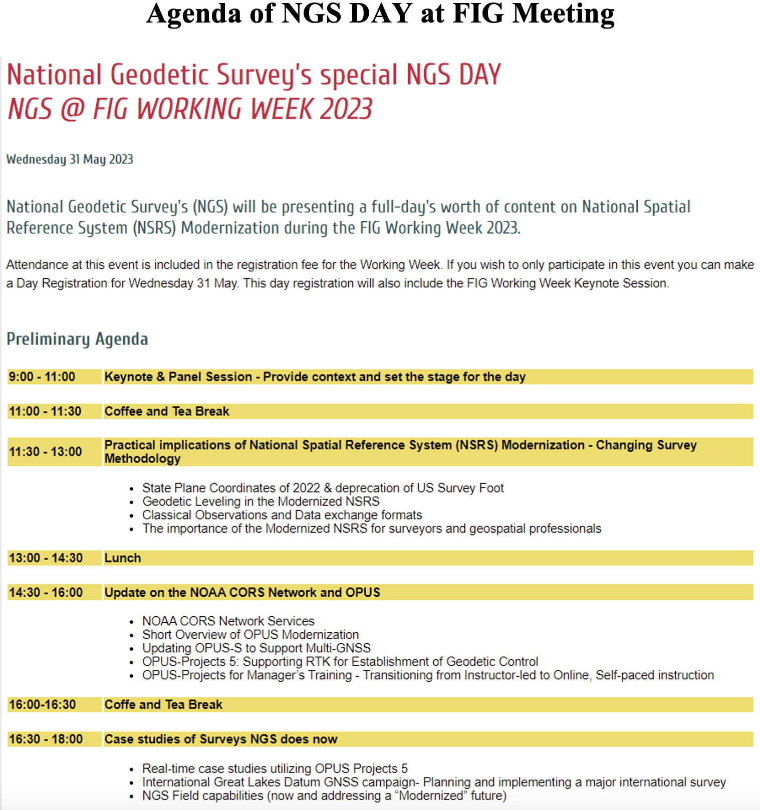
The image below provides a list of NGS presentations with scheduled times. There will be a panel session in the beginning of the day to set the context for the day.
Agenda of NGS DAY at FIG Meeting (Image: FIG website)
As in most conferences there are several ways participants can register, one day to the entire conference. This is a great opportunity to have discussions with the leadership of the National Geodetic Survey and individuals working on the development of the new, modernized NSRS.
Image: FIG website
There are a lot of presentations on various topics so, I would encourage readers to look through the entire agenda. FIG’s technical work is led by ten commissions. The August 2021 column provided information about the FIG commissions. See the list of commission below:
Commission 1 – Professional Standards and Practice Commission 2 – Professional Education Commission 3 – Spatial Information Management Commission 4 – Hydrography Commission 5 – Positioning and Measurement Commission 6 – Engineering Surveys Commission 7 – Cadastre and Land Management Commission 8 – Spatial Planning and Development Commission 9 – Valuation and the Management of Real Estate Commission 10 – Construction Economics and Management
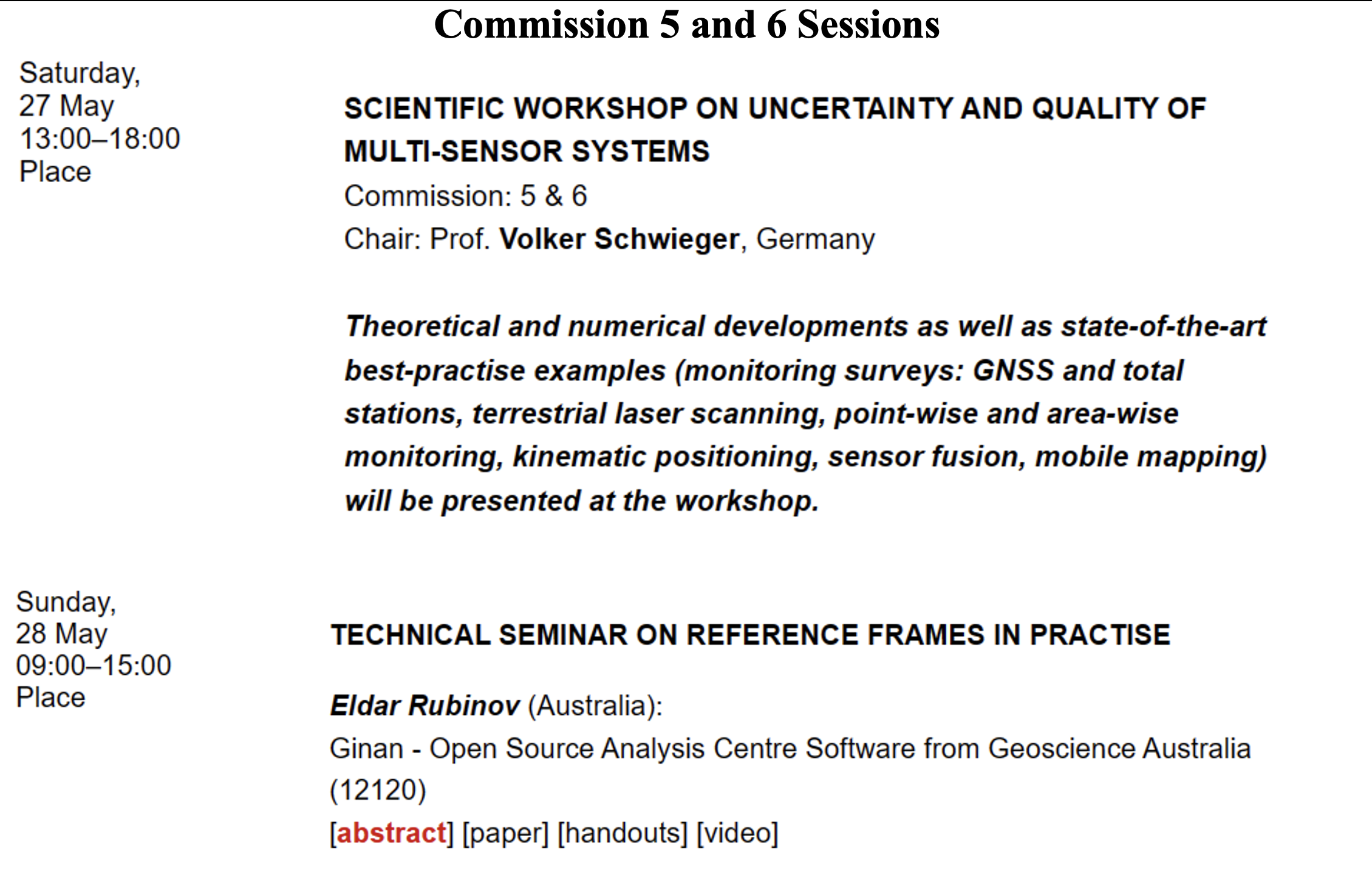
The full technical program lists the topics by date and time. I highlighted sessions by commission 5 and 6 that I think would be interested to the surveying and mapping community. See the image below.
Image: FIG website
Image: FIG website
Image: FIG website
Image: FIG website
Image: FIG website
Image: FIG website
Image: FIG website
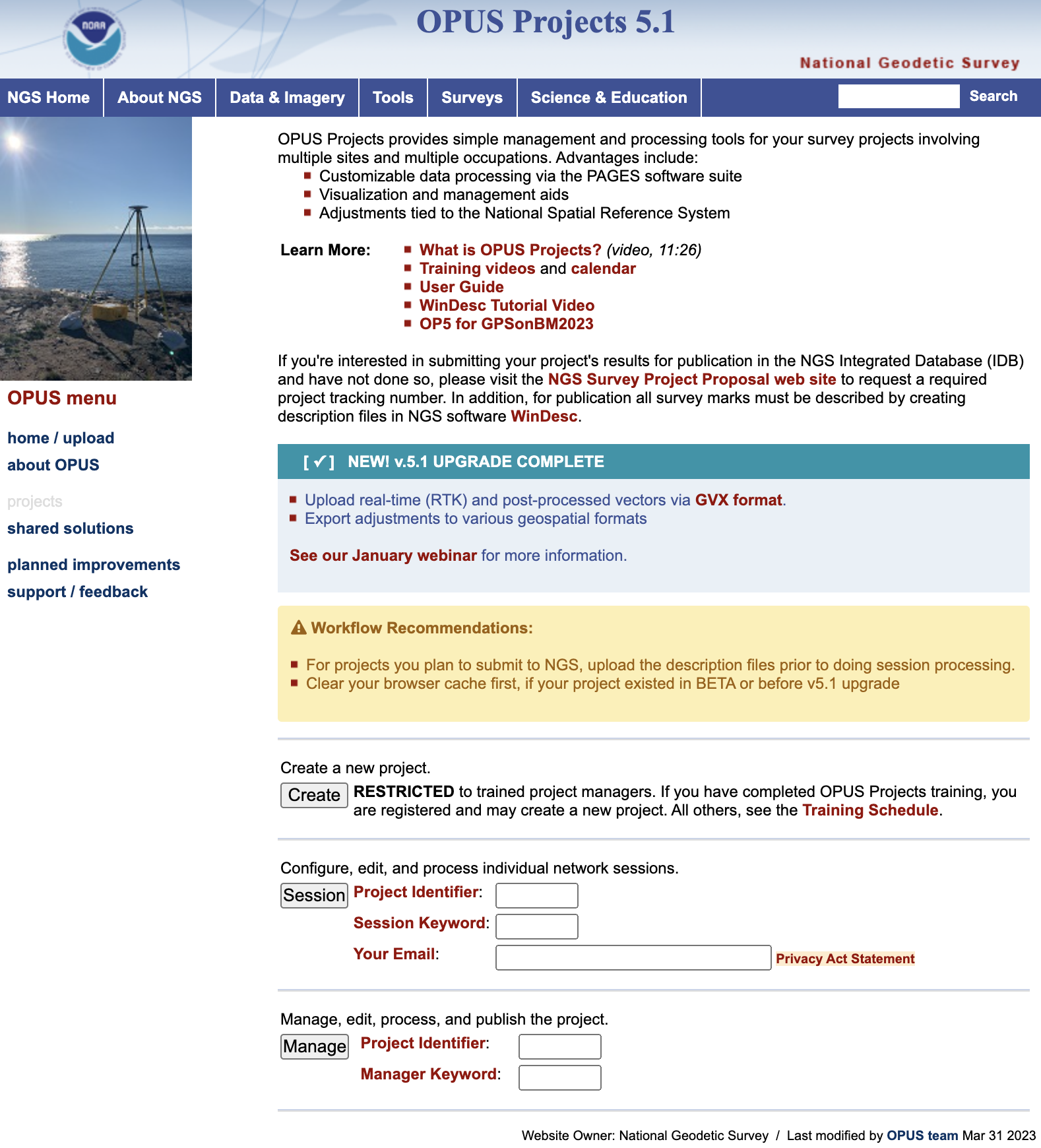
Finally, I would like to highlight a NGS product that is now in production mode. That is, OPUS Project 5.1 is now a production product. *NGS did not make an official announcement about this change, but if you access OPUS Project the new version comes up. As described in the March column, OPUS Project 5.1 routine allows the use of RTN vectors and post-processed vectors from vender software.
Clicking the “projects” icon on the OPUS page connects you to the latest version of OPUS Project 5.1. See image below. Please see the March column or NGS’ January webinar to learn more about OPUS Project 5.1.
Image: NGS Website
*Note: As of the writing of this column, March 29, it is still listed on the beta release section of NGS website. If you click on OPUS Project 5.1 in the Beta Release section, it will link to the production version of the routine.
In July 2020, my First Fix article discussed the Geodesy Crisis in the United States. In January 2022, Mike Bevis, collaborating with others, prepared a white paper titled “The Geodesy Crisis,” documenting the concern about the lack of trained geodesists in the United States. Since then, my November 2022 survey scene column highlighted that without investment in geodesy, the United States will not have the available skills and knowledge to develop new geodetic technologies and improve models to address challenges to society. In December 2022, Matteo Luccio discussed the urgent need for U.S. geodesists with Everett Hinkley, who works for the federal government, serves as a subject-matter expert on several high-level boards, and dubs himself a “concerned citizen geodesist.”
Well, things are starting to happen. NGS is soliciting grant proposals from eligible organizations to implement activities that modernize and improve the National Spatial Reference System (NSRS) and advance the science of geodesy in the United States. See the image below.
I realize that this is very short notice, but all Letters of Intent (LOIs) must be received no later than Wednesday, March 22, 2023. Full proposals do not have to be completed until April 24, 2023. The grant information and related material can be found here.
This is a great opportunity for institutions of higher education, state, local and Indian tribal governments to partner with industry and private consultants to advance the science of geodesy.
What are your thoughts on the “geodesy crisis” and what do you propose to address it?
Bernard Gruber
“Evidence seems to be very clear that we, as a country, need geodesists and that there has been a decline in investments, training, and research in geodesy. While our decline relative to China may be shocking, it should not be surprising. U.S. industry and government relentlessly pursues STEM graduates, or those with relevant experience, but that does not meet current needs. Besides maybe surveying, it is unclear to the public what the geodesy profession is all about, why it is needed, and quite frankly, why it is an exciting career choice.”
— Bernard Gruber Northrop Grumman
Does crowding of low-Earth-orbit (LEO) space — with new satellites and space debris — pose any problems for the launch or operations of GNSS satellites in medium Earth orbit (MEO)?
Ellen Hall
“This was a focused topic at SATELLITE 2022, where the discussion centered on the 6,000 tons of space debris circulating in LEO. Even the smallest piece of debris can be lethal to a satellite, so the key is to track and maneuver where possible. Add to that about 5,000 active satellites and plans to launch tens of thousands of additional ones into LEO over the next few years, and you have a serious problem to overcome. While there are treaties and plans for tracking and maneuvering these satellites, the debris is the real challenge.”