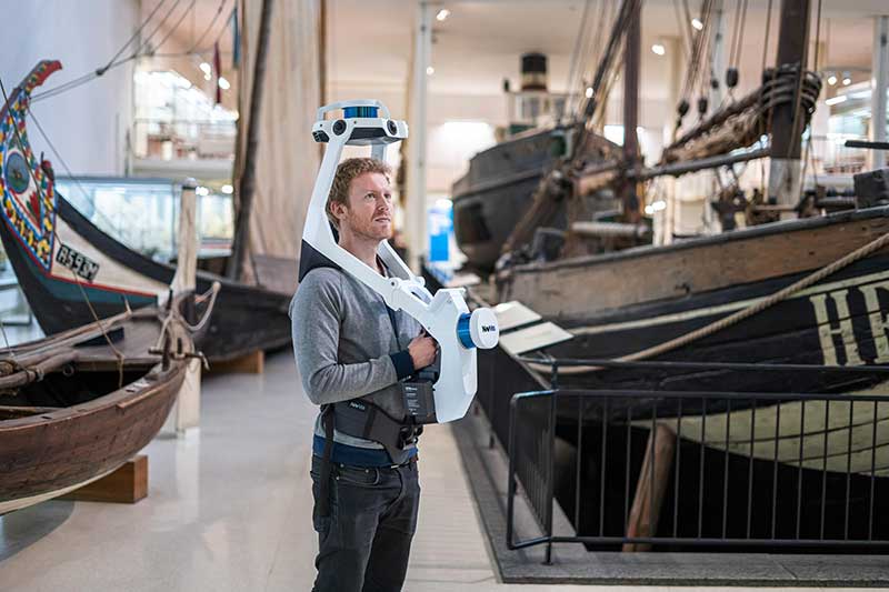
The all-in-one reality capture capabilities of NavVis VLX include both survey-grade point clouds and high-resolution panoramas. (Photo: NavVis)
NavVis has launched NavVis VLX, a wearable mapping system that captures high-quality data in built environments such as construction sites, staircases and small technical rooms.
The all-in-one reality capture capabilities of NavVis VLX include both survey-grade point clouds and high-resolution panoramas. The combination of high-quality data capture and a compact, economical design will transform the way architecture, engineering and construction (AEC) projects are captured with fast, efficient scanning for BIM and CAD applications, while also extending the scope of projects to new deliverables such as web-based digital twins, the company said.
NavVis VLX is equipped with two lidar sensors and captures survey-grade point clouds using the company’s SLAM technology, which was originally developed for the the NavVis M6 indoor mobile mapping system. NavVis VLX also captures high-resolution panorama images in a complete 360-degree field of view.
According to the company, this wearable device gives the operator more control over where the sensors are scanning. It also allows the user to view and interact with the built-in screen that provides live feedback of what has been scanned and the quality of the data being captured.
“We designed NavVis VLX to provide the AEC industry with a compact, versatile device that efficiently captures buildings and still delivers survey-grade point clouds,” said Georg Schroth, NavVis CTO. “Knowing that there is still an unmet need for high-quality mobile data capture in a wider range of building documentation applications, we set out to develop a more versatile device that can achieve what NavVis M6 does at a smaller scale and on a lower budget.”
According to NavVis, the data captured by the VLX can be applied to a wide range of applications, including conventional building documentation such as CAD drawings and BIM models, as well as to innovative digital twin solutions, such as NavVis IndoorViewer.
NavVis, headquartered in Munich, Germany, is a global provider of indoor spatial intelligence technology and solutions for enterprises. The company also has offices in New York and Shanghai.
Enables building stakeholders to take accurate measurements based on point clouds
The latest release of the NavVis IndoorViewer 3D building visualization software features a new tool that lets building stakeholders take highly accurate measurements based on point clouds in the realistic 360° image view.
NavVis, global provider of indoor spatial intelligence technology and enterprise solutions, announces the release of NavVis IndoorViewer 2.6. This major software release includes a new measurement tool that lets users take highly accurate measurements based on point clouds in realistic browser-based digital buildings.
This release also makes additional features available to structured e57 point cloud files, including automatically generating highly detailed floor plans and routing.
NavVis IndoorViewer is a popular deliverable among building stakeholders without the technical expertise to work with point clouds and modeling software, thanks to the realistic digital buildings and intuitive interface.
One of the features that has proven to be useful among users across multiple industries is the measurement tool. It enables users to take measurements remotely on any device, saving time otherwise spent traveling to the site.
The release of version 2.6 of NavVis IndoorViewer marks a major advance in the accuracy of virtual measurement tools. The tool has been redesigned to overcome two of the biggest problems with virtual measurement tools – accuracy and usability.
On the one hand, point cloud measurements are quite accurate. But often these software tools are not accessible or even usable for a wide range of building stakeholders who lack the expertise in working with point clouds. If, on the other hand, the tool uses images or even meshes, which are much more user-friendly than point clouds, the tools are usually not reliable enough to produce accurate results.
The new measurement tool in NavVis IndoorViewer combines the best of both worlds, thanks to a patent-pending magnifying feature that appears when taking measurements in the realistic 360° view. The magnifying feature reveals the exact section of the point cloud behind the image and lets users pick the point cloud point as the basis for a measurement while benefiting from the intuitive interface of the fully immersive walkthrough.
“When redesigning the measurement tool in NavVis IndoorViewer, we wanted to make sure that a wide range of stakeholders in every industry that works with built environments could benefit from the accuracy of point clouds when taking virtual measurements,” said Georg Schroth, NavVis CTO. “We are confident that the new magnifying feature in NavVis IndoorViewer achieves our goal. Now even stakeholders that are unfamiliar with point clouds have an easy, intuitive way to take measurements based on this highly accurate real world data.”
In addition to making strides in the accuracy of remote measurements, the interface of the tool has also been fully redesigned. This includes a new slider function that lets users view the 2D floor plan and 3D walkthrough side-by-side or move from one view to the other.
The dual view provides an overview of the entire building so that users can easily locate an asset or area while also viewing the location in the realistic 360° view. The fully immersive walkthrough makes it possible to virtually move through the area being measured or inspect the asset, as if the user were on site. Measurements being taken show up in both views.
The release of NavVis IndoorViewer 2.6 also introduces new feature support for e57 point cloud files captured by static scanners. Previous NavVis IndoorViewer releases have included a popular feature that lets laser scanning professionals upload structured e57 point cloud files and automatically generate realistic, fully immersive 360° walkthroughs that can be published and shared with clients as a web-based link.
With the release of NavVis IndoorViewer 2.6, two popular features that were previously only compatible with scan data captured by NavVis hardware are now available for point clouds uploaded as structured e57 files. The first is the generation of a navigation graph, which makes it possible to turn static scans into a fully immersive indoor routing tool. The second is the automatic generation of highly detailed floor plans. Now point cloud files uploaded as structured e57 files can be turned into digital floor plans in a few clicks.