The v4.1.0 update includes new SouthPAN SBAS capabilities and additions to the graphical user interface (GUI).
Ginan is an open-source toolkit for creating precise point positioning (PPP) analysis products, correction streams and positions. It is being actively developed in a Geoscience Australia Positioning Australia program.
The source code for the current version of Ginan is available for download from GitHub. New versions of Ginan with enhanced capabilities will be developed and released over time.
Geoscience Australia is establishing operational instances of Ginan that produce PPP analysis products and streams on a continuous basis, and which are available free of charge.
Geoscience Australia has released Ginan V4, the latest version of its home-grown, open-source toolkit for precise point positioning.
Developed under the Positioning Australia program, Ginan V4 delivers world-class GNSS capabilities to innovators, researchers and industry professionals.
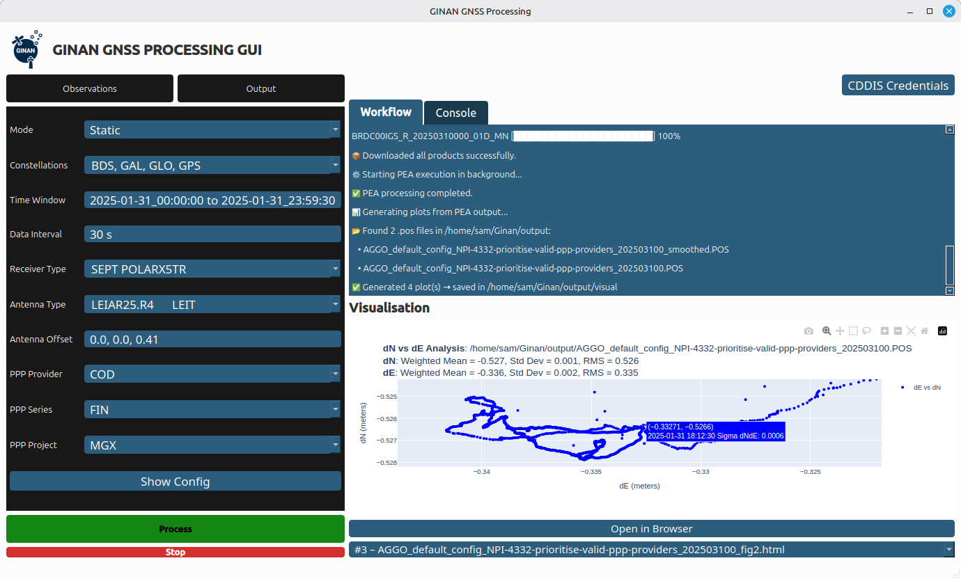
Version 4 features a new intuitive graphical user interface (GUI) that makes data processing faster, easier and more accessible. The new GUI was designed to lower the barrier to entry for users across sectors. With simple data loading and streamlined output downloads, the new interface enables anyone — from navigation specialists to disaster response teams — to harness centimeter-level accuracy without needing advanced technical expertise.
Ginan V4 also introduces enhanced robustness and improved software formatting, reducing errors and accelerating processing speeds. Users can expect smoother workflows and reliable results, whether calculating orbital mechanics or pinpointing precise locations on Earth’s surface.
Ginan V4 remains fully modular, empowering users to build their own capabilities depending on their needs. From surveying and geospatial analysis to emergency response and scientific research, the toolkit supports innovation across diverse applications.
Key benefits of Ginan V4
User-friendly interface. Simplifies data loading and output generation.
Enhanced robustness and speed. Fewer errors, faster processing.
Modular design. Customize capabilities for orbital mechanics, surveying or disaster response.
GNSS accuracy. Centimeter-level precision based on satellite observations.
Free and open source. Available to download via Geoscience Australia’s GitHub.
As part of Positioning Australia’s suite of capabilities, Ginan V4 reflects Geoscience Australia’s commitment to delivering GNSS capabilities that support innovation, safety and productivity. By making the software free and open source, the program ensures that Australian expertise continues to drive global advances in positioning technology.
Ginan V4 is available for free download on Geoscience Australia’s GitHub. More information can be found at ga.gov.au/positioning.
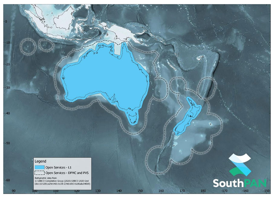
SouthPAN early Open Services coverage. (Image: Geosciences Australia)
The government of Australia has awarded Lockheed Martin a $1.18 billion contract to establish the Southern Positioning Augmentation Network (SouthPAN) to enhance precision.
The system is expected to be fully operational by 2028, and will be provided as a service for 19 years with an option to extend.
The program will use a unique, Lockheed Martin-developed, second-generation satellite-based augmentation system (SBAS) broadcasting on two frequencies to augment signals from two GPS and Galileo.
The SouthPAN initiative
The SouthPAN initiative will deliver a signal augmenting GPS and Galileo over the Australasia region, improving accuracy from 5-10 meters to within as little as 10 centimeters.
The greater positioning accuracy and integrity of the SouthPAN signal has applications across a range of users, including civil aviation, vehicle guidance, precision agriculture for efficiencies in crop management, tracking maritime shipments, and enabling navigation for drones and other unmanned vehicles.
Lockheed Martin Australia will work with the SouthPAN project team to establish a network of GNSS reference stations and satellite uplink facilities that will enable communications and transmissions with the SouthPAN space infrastructure.
SouthPAN is a partnership between Geoscience Australia and Toitū Te Whenua Land Information New Zealand (LINZ) under the Australia New Zealand Science, Research and Innovation Cooperation Agreement.
2017 testbed
Lockheed Martin tested a second-generation SBAS testbed in partnership with Geoscience Australia in 2017.
Lockheed Martin’s second-generation SBAS technology receives and monitors basic signals data from multiple GNSS through widely distributed reference stations. This data is collected by a SBAS testbed master station, which computes corrections and integrity bounds for each GNSS satellite signal, and generates augmentation messages.
The new messages are sent to an SBAS payload hosted aboard an Inmarsat geostationary Earth orbit satellite via an uplink antenna in Uralla, New South Wales. The Inmarsat satellite rebroadcasts the augmentation messages containing corrections and integrity data to the end users’ GNSS receivers. The whole process takes less than six seconds.
Lockheed Martin provided the systems integration expertise in addition to the Uralla radio frequency uplink; GMV-Spain provided its “magicGNSS” processors; Inmarsat provided the navigation payload hosted on the 4F1 geostationary satellite. The Australia and New Zealand Cooperative Research Centre for Spatial Information coordinated the demonstrator SBAS test-bed SBAS test-bed projects.
The SouthPAN contract will expand Lockheed Martin’s investments toward sustainable business growth in Australia. Currently, Lockheed Martin programs support 4,000 Australian jobs in advanced manufacturing and technology industries. The contract will grow that footprint with additional jobs in at least four states.