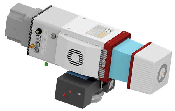
The miniVUX-2UAV airborne laser scanner. (Photo: Riegl)
The Riegl miniVUX-2UAV is a lightweight airborne laser scanner designed specifically for integration with unmanned aerial vehicles and systems.
Riegl added the new miniaturized UAV sensor to its portfolio of professional solutions for UAV-based surveying.
The sister type of the miniVUX-1UAV sensor, the miniVUX-2UAV offers 100 kHz and 200 kHz PRR. With the 200-kHz PRR, the sensor provides up to 200,000 measurements per second, and thus a dense point pattern on the ground for UAV-based applications that require the acquisition of small objects.
The Riegl miniVUX-2UAV makes use of Riegl waveform lidar technology, allowing echo digitization and online waveform processing. Multi-target resolution is the basis for penetrating dense foliage, and the wavelength is optimized for the measurement of snowy and icy terrain.
In addition to the stand-alone version of the miniVUX-2UAV, Riegl also offers fully-integrated solutions.
The GPS World staff reported live from Intergeo Sept. 17-19 in Stuttgart, Germany. The massive trade show, dubbed the “global hub of the geospatial community,” brings together more than 19,000 visitors from more than 114 countries and features approximately 640 exhibitors. Check out the latest industry news, as well as photos and videos from the event.
The Geospatial Management Office (GMO) is the designated coordinator of geospatial activities throughout the core of the Department of Homeland Security headquarters and its component agencies.
Part I described how and why the GMO was formed and some of the early activities when resources were limited and expectations were low. Following the devastation along the Gulf States from Hurricane Katrina, the efforts to coordinate and empower the GMO gained focus and energy.
Image: USDHS
Needed: Better coordination
The magnitude of devastation caused by Hurricane Katrina, the uneven response and the inability for all levels of government to act in a unified manner prominently showed the gaping hole in the nation’s geospatial coordination mechanisms. The irony in this lack of coordinated government action, and the blame placed on President Bush’s administration, was that the lack of a geographic framework had been identified as a vulnerability since the late 1800s following the Civil War and never fully addressed.
A patchwork of Executive Orders and other stop-gap actions were in place, but action was needed by the Legislative Branch to finally address this, and, as is too often the case, it took a major disaster to cut through the politics and make this happen, resulting in the Geospatial Data Act. For a more in depth analysis of the Geospatial Data Act read the November 2018 Geospatial Solutions article “Geospatial Data Act Will Bring Huge Changes to America and the World.”
Hurricane Katrina had a sobering influence on federal agencies, providing renewed focus to find new ways to share information, and communicate openly and effectively using a common standard and language.
Dan Cotter, director of the GMO from 2005 through 2007, understood this challenge. Following his predecessor, Ryan Cast (the first director of the GMO), Cotter furthered the relationship with the Federal Geographic Data Committee (FGDC), establishing a Homeland Security Working Group with several sub-groups to advance DHS’s mission. Heavy lifting began on the symbol standards, data model and the U.S. National Grid (USNG).
This collaborative effort was furthered when the GMO secured funding for the first agency-wide enterprise license agreement (ELA) with Esri for GIS applications, training and services. The ELA reduced the cost and administrative difficulties surrounding procurement of GIS software. This dramatically increased the number of GIS practitioners seeking to partner with DHS, FEMA and the GMO.
Cotter was tapped to be the DHS chief technological officer in March 2007, passing leadership to Jeff Booth, who advanced the portfolio and led significant efforts to optimize the geospatial toolset of DHS while migrating it into the federal data-center environment.
Establishing a culture of trust does not come easy in bureaucracies, and this was no different for DHS. Being a relatively new agency, agility and eagerness were key traits, especially with a very fast-paced and high-stakes environment. People would volunteer to take on requested tasks, but that blurred the lines of responsibility.
The launch of GeoCONOPS
The HSE GeoCONOPS is a strategic roadmap to understand and improve the coordination of geospatial activities across the entire spectrum of the Nation. Updated on July 22, 2019, (Graphic: GeoPlatform.gov)
The FGDC and other working groups helped make introductions for the DHS GMO, which furthered the need to clarify each department’s role in the bigger geospatial picture. Defining these various operational roles and responsibilities led to the creation of the Geospatial Concept of Operations, or GeoCONOPS.
GeoCONOPS was a multi-year initiative, and is a playbook for a range of disaster-related events. Though initially limited to the disaster response and FEMA’s mission, GeoCONOPS was a structured community effort to clarify the types and timing of critical geospatial data and analysis needed in a disaster and continues to grow to address other DHS mission areas.
GeoCONOPS was initially published annually as a book, but changes were made too often and it is now only maintained as a website. GeoCONOPS describes the use of geospatial technology in the five mission areas of DHS:
Prevent
Protect
Mitigate
Respond
Recover
It also contains a curated inventory of geospatial resources available to the homeland security enterprise. The final version of the book (v.6, 2015) is available for download. Though often seen as a product, it is likely that the process behind the GeoCONOPS development was of equal or more value as it helped to define the lanes and build much-needed trust among the federal geospatial actors.
Cover of HSE GeoCONOPS resource book, v.4. (Image: Geoplatform.gov)
Through this effective collaboration model, the GMO benefitted from other significant advances elsewhere in the agency and the broader geospatial community. The development of the Homeland Security Information Network (HSIN) delivered value as a portal for the exchange of information and geospatial products on a common operating network among DHS member partners. If there is a major event taking place, such as political conventions, the Super Bowl, or the Boston Marathon, HSIN is sure to be part of the event’s command and control.
Its value was further proven by leveraging HSIN’s user-authentication capability, providing a trusted access-control mechanism for HSIN and other web-hosted geospatial capabilities. These access controls greatly reduced the deployment burden on the Geospatial Information Infrastructure (GII), which is an on-premises version of Esri’s ArcGIS Online suite.
The GII allows for trusted partners to gain access to hosted data, create working groups, and develop and share maps and geospatial applications. The GII also provides access to customized Common Operational Picture (COP) applications providing geospatial situational awareness for a number of operational partners.
These COPs are a result of their own evolutionary pathway, leveraging technology developed by and for the National Geospatial-Intelligence Agency (Palenterra) and through a first-generation viewer called the Infrastructure Critical Asset Viewer (iCAV). Now, with the tools in the GII, highly customized COPs and dashboards are developed for specific events and incidents and shared on an as-needed basis with the full range of stakeholders.
Where NGA and DHS intersect
DHS’s development of a national geospatial dataset put NGA and DHS on intersecting paths. The National Geospatial-Intelligence Agency (NGA) only focused on foreign threats and supporting the warfighter, but after the attacks of September 11, 2001, homeland defense was added to its mission.
NGA’s proven success internationally allowed it to quickly focus on acquiring and developing the best available sources of data. This conventional mission for NGA led to the formation of a new stakeholder group; hence, the creation of the Homeland Foundation Level Data (HIFLD) committee, which developed the first national dataset designed for homeland security and critical infrastructure protection, the Homeland Security Infrastructure Program (HSIP).
Having been initiated in the intelligence community, HSIP’s distribution was strictly limited, which inhibited its adoption across the mission space. To broaden its use, plans were developed to migrate all or much of the program to DHS and to shift the burden of restriction from the need-to-justify sharing to the need-to-justify restricting. With this new emphasis on sharing and openness, HSIP evolved to the current HIFLD Open and HIFLD Secure versions.
The GMO solidified its mission and purpose with the elements of community, transparency, security, technology and data falling into place. Through the leadership of the former GMO directors, the foundation they laid established the GMO as a respected and strong advocate throughout the agency and its partners, from local governments up to the federal level, becoming known as the Homeland Security Enterprise (HSE).
The HSE established a very real link extending from the on-scene first responder to the White House. By the time David Alexander, Ph.D., passed the baton to David Lilley in 2016, the GMO could deliver on its promises and was ready to expand outward. Lilley focused on realigning efforts to match DHS’s policy supporting National Special Security Events (NSSE) and community outreach through its network of 78 fusion centers.
Shortly after Lilley departed DHS, Hurricane Harvey’s torrential downpours and historic deluge began. Acting Director Michael Donnelly agreed to an innovative HIFLD solution to support FEMA operations to help mitigate the flood of data and requests that typically accompanies events of this magnitude.
Hurricane Harvey was Donnelly’s initiation. Following this and storms that followed, Donnelly focused on steadily maturing the GMO through deliberate outreach efforts and strengthening partnerships, building on outreach to regional fusion centers and non-traditional mission areas such as cybersecurity.
While not typically an operational player, the DHS Geospatial Management Office has become a trusted partner to those on the front lines, providing expertise, data, insights and architecture. The GMO is a foundational resource for operators, elevating their capabilities as a force multiplier.
While we can only hope against another cataclysmic natural disaster or major attack, when one does occur, the nation’s geospatial community is better prepared to respond to and recover from whatever comes.
As the saying goes, the better one strives to become, the greater becomes one’s enemies; so, as threats continue to evolve, our investments into geospatial technologies and critical infrastructure will pay dividends now and in the future helping to secure America’s safety here and abroad.
Remember, next time you are watching a large, national level sports game or a big storm approaching, know that others are watching, too. Behind the scenes another game is being played — one with much higher stakes. The players, you’ll not see, and the names, you’ll never know, but safety is their mission and GIS one of their primary tools.
Nate Smith — co-author and main contributor because of his work with the GMO — gave the following presentation to GeoDC, Washington, D.C.’s, geospatial community of interest on GeoCONOPS.
Epilogue
An inspiration for this article was to recognize the DHS GMO and its partners for their growth and utility as demonstrated during Hurricane Harvey, on the assumption that it was not otherwise acknowledged by the community. Well, awkwardly, in between this two-part drama, recognition did come from the Federal Geographic Data Committee in the form of the 2018 Doug D. Nebert National Spatial Data Infrastructure (NSDI) Champion of the Year Award.
Nate Smith has worked at the confluence of geospatial information and disaster management in both the domestic (U.S.) and international domains since 1992. He has been an innovator and pioneer in this discipline through his work supporting USAID’s Office of Foreign Disaster Assistance, FEMA’s GIS Solutions Branch and the DHS Geospatial Management Office.
He refined his knowledge of requirements through work as an emergency first responder and international humanitarian, and has shared his knowledge and experience through courses delivered at a number of Universities. His background includes deployments to disaster locations around the world in support of operations and coordination efforts for events ranging from insect infestation to conflicts.
He is currently an independent consultant affiliated with the Florida International University Extreme Events Institute and FIU’s Academy for International Disaster Preparedness. He earned a BA in Geography from UMBC and a Masters in Urban and Regional Planning from Virginia Tech.
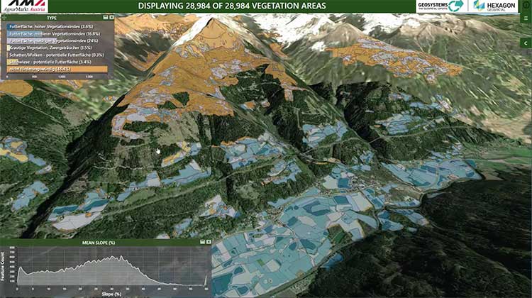
Hexagon’s Geospatial Division launched M.App Enterprise 2019 at its user conference, HxGN LIVE 2019. The latest version of M.App Enterprise integrates capabilities from Hexagon’s Luciad Portfolio to enhance data visualizations, analytics and management.
Designed to monitor assets, evaluate changes, and take action, M.App Enterprise is a privately-hosted platform that allows organizations to deploy Hexagon Smart M.Apps that dynamically address their location-based business problems.
The new features in M.App Enterprise 2019 lay the foundation for users to experience a 5D smart digital reality, where data is connected seamlessly through the convergence of the physical world with the digital and intelligence is built into all processes.
Screenshot: Hexagon Geospatial
“The enhanced M.App Enterprise is now powered by our Luciad technology, which allows users to have the best of both worlds when it comes to data visualization and advanced analytics to communicate information effortlessly, and in real-time,” said Georg Hammerer, chief technology officer – applications for Hexagon’s Geospatial Division. “This unified geospatial enterprise platform can now further enable users and partners to create vertical solutions for their markets and industry segments.”
The Luciad Portfolio integration will allow users to connect to, visualize and examine file-based vector and raster data from their Smart M.Apps in 3D. It also now renders terrain features realistically based on elevation data of the area.
For covering large geographical areas with a higher resolution, M.App Enterprise 2019 allows users to connect to tiled elevation coverages offered by LuciadFusion.
Furthermore, the addition of classification algorithms to the Spatial Workshop user interface enables M.App Enterprise to perform advanced remote sensing with machine learning.
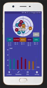
Global GNSS, a subsidiary of Polosoft Technologies, has launched a new mobile application named GNSS Surveyor, which is designed for the geospatial industry.
The application GNSS Surveyor provides location information and quality position data in real-time with sub-meter to centimeter accuracy. It needs to be connected to any external GNSS receiver via Bluetooth.
Features of the application include:
A one-touch configured command to communicate directly with the GNSS Bluetooth device.
Location information and quality of the position data in real-time with centimeter accuracy.
GPS data such as position, height, satellites and velocity.
Constellation information for GPS, GLONASS, Galileo, BeiDou, QZSS and SBAS satellites in the orbit.
Direct IP feature for RTK corrections data.
DMS to DD conversion or vice versa.
Real-time kinematic (RTK) correction data can be forwarded to a high-accuracy external device. The internal NTRIP client loads the RTCM data from the internet.
With GNSS Surveyor, location information is collected as latitude and longitude, altitude, speed or pace, bearing and UTC time.
GNSS precision includes global coverage, centimeter-level accuracy, fast time to first fix, multi-constellation and multi-band, and highest security, the company said.
Navigation uses include ground robotics navigation, lane-level navigation, heavy machine navigation, industrial navigation and tracking and commercial UAV.
Includes first draft of best practices for implementing GIS in elections.
Photo: iStock.com/YinYang
The National States Geographic Information Council (NSGIC) has released the first-year report of phase one of its Geo-Enabled Elections project, highlighting the project’s accomplishments in the first 12 months. These include completing a baseline assessment of how far states have come, to date, in terms of integrating geographic information systems (GIS) with electoral systems, as well as assembling a team of leaders and experts to help guide the project.
The project team has also facilitated conversations with a wide range of stakeholder groups, aimed at raising awareness of the importance of using geospatial technology to increase reliability and accuracy in elections.
The Geo-Enabled Elections project, phase one, runs from Oct. 1, 2017, to Sept. 30, 2019, with the aim to help strengthen electoral systems by supporting states in the adoption of GIS. Concretely, this means encouraging state governments to replace non-spatial “address file” systems with election precinct and voter data in a GIS format, leveraging that format’s inherent visual and analytical advantages.
The Geo-Enabled Elections project is partly funded by the bipartisan Democracy Fund Voice.
“During this first year, we’ve been encouraged to learn that while most voter data across the country is still kept in ‘address file’ tables, many state election directors are interested in the benefits that GIS can bring. Additionally, since most state governments have a geographic information officer (GIO) or equivalent on staff, the prospects for strengthening elections through the integration of GIS into electoral systems are very good,” said Dan Ross, NSGIC president and GIO for the State of Minnesota.
As part of the Geo-Enabled Elections project, NSGIC has been able to help build stronger connections between state officials responsible for the electoral system and state-level GIS subject matter experts, a critical first step towards the successful implementation of GIS in elections.
The organization, which is quickly becoming recognized as the center of expertise for how GIS can be deployed to strengthen electoral systems, also released the first draft of its best practices for how states may go about enhancing election accuracy using GIS. The five identified best practices are:
Convene a team of specialists
Collect and sustain a statewide voting unit GIS layer
Adopt and implement a statewide geocoding strategy
Assemble and provide best Available contextual GIS layers
Define and implement data validation processes
These draft best practices will be put to the test and further refined in five state-wide pilot studies taking place during the project’s second year. The best practices can be viewed in full as part of the first-year report.
NSGIC’s report also outlines the work that lies ahead for the project, as well as opportunities to impact geo-enabled elections in phase two of the project (pending funding).
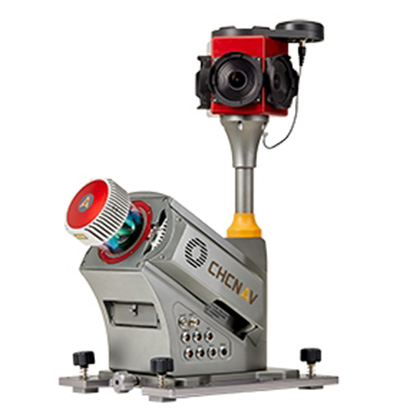
CHC Navigation has launched the Alpha3D Mobile Mapping solution, which provides a unique combination of sensor technologies and the company’s core GNSS expertise.
The Alpha3D is a high-performance, vehicle-independent mobile mapping solution that can capture mass data in continuously changing world environments, enabling geospatial professionals to get work done quickly and more accurately to increase their return on investment.
The Alpha3D can be mounted on a variety of platforms, including different type of vehicles, trains, railway trolleys and boats. It rapidly and efficiently collects high density, accurate point clouds and powerful image data. It also adds extra information from additional sensors, such as a high-resolution camera, thermal camera, echo sounder or extra profiler.
The Alpha3D combines high-performance hardware — including a long range, ultra-high speed, precise laser scanner, high-resolution HDR panoramic camera in combination with an advanced GNSS receiver and high-precision inertial measurement unit (IMU) — in one instrument in a light weight, compact yet rugged design, according to George Zhao, CEO of CHC Navigation.
“All theses features keep Alpha3D as one of most innovative system in market today,” Zhao said.
“With Alpha3D, users can collect more data faster and reduce time in the field more than 40% compared to traditional surveying instruments,” said Andrei Gobb, product manager of Mobile Mapping Solutions. “By combination of point clouds and high-resolution images, as well as information from additional sensors, there is no need to return to site for remeasurement.”
Extensis and LizardTech are uniting as one global company to help organizations increase their return on investment and the value of their digital assets, fonts and large imagery.
In 2017, Extensis and LizardTech collaborated on the development of new portfolio asset geo-referencing capabilities for applications in the geospatial, infrastructure, architecture/engineering/construction and building information modeling segments.
With Extensis’ market leadership in digital asset and font management combined with LizardTech’s expertise in image management and image compression technology, the united company is situated to provide a suite of solutions and support for digital asset challenges.
“Organizations today are investing in imagery of all kinds, including photography, aerial, and spatial, to name a few,” said Osamu Ikeda, CEO of Extensis. “Fully leveraging these digital files means having an easy and efficient way to organize, store, access and distribute them.”
Ikeda continued, “Uniting Extensis and LizardTech strengthens our ability to support our customers’ success and give them effective and time-tested solutions for maximizing the value of digital assets of all kinds.”
The combined company will operate under the Extensis brand, headquartered in Portland, Oregon, with an office presence in Seattle.
Starting now, LizardTech products (GeoExpress, Express Server, GeoViewer) will become part of the Extensis suite of solutions, which spans digital asset management, font asset management, brand asset management, image management and image compression.
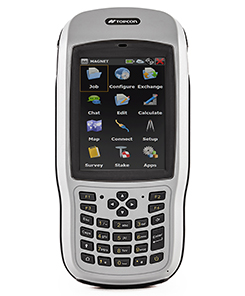
Topcon Positioning Group has introduced the T-18 handheld controller, which is designed to drive geopositioning, construction, mapping and vertical construction applications.
The controller includes a 3.7-inch sunlight-readable display with a 1-GHz processor, 1 GB of internal storage and up to 10 hours of battery life, the company said.
For data collection using Topcon’s MAGNET Field software, the T-18 controller offers a durable ergonomic solution with fast processing, a large screen, excellent connectivity and a long battery life.
Topcon MAGNET Field software offers a complete field solution for geopositioning professionals, enabling users to collect survey mapping data and perform construction and road layout using total stations, levels and GNSS receivers.
The T-18 features a 3.5G cellular modem for connectivity with Topcon MAGNET solutions for sending and receiving data to the cloud company account.
“The cellular option makes it easy to communicate with field crews when projects need to be changed or if important data is required back in the office. Additionally, the modem can be used for RTK (real-time kinematic) correction services,” Kerwin said.
Other key features include standard Bluetooth and Wi-Fi connectivity, as well as an IP65 rating for dust and water protection in demanding job site conditions.
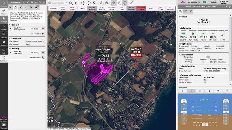
SenseFly is partnering with Trimble to optimize the drone mapping workflow for geospatial professionals.
The new integration is designed to ensure a smooth end-to-end mapping drone workflow. senseFly operators can now, within the recently launched eMotion 3.5 software, transform a senseFly S.O.D.A. camera’s georeferenced imagery into an automatically collated project (in .jxl format).
This enables the one-click import of drone imagery into the Trimble Business Center Aerial Photogrammetry module without the need for manual project creation and organization of images.
The senseFly-to-Trimble mapping workflow includes:
planning and monitoring a senseFly S.O.D.A.-based drone flight (in eMotion 3.5)
downloading the drone’s images for one-click georeferencing in eMotion 3.5 (Flight Data Manager)
clicking to create a .jxl format mapping project
opening a project within the Trimble Business Center Aerial Photogrammetry module
processing the drone’s imagery to generate orthophotos, contour maps, point clouds, digital surface models (DSMs) and feature maps
analyzing and acting upon the data.
Screenshot: Trimble
“Making work easier and more efficient for geospatial professionals is the goal that drives every solution we develop,” said Jean-Christophe Zufferey, senseFly co-founder and CEO. “Therefore, we are excited to collaborate with Trimble on more tightly integrating our solutions, since enhancements such as this new eMotion-to-Trimble Business Center workflow do exactly that, ensuring that the transition from data collection to acting upon this data is as seamless as possible.”
The senseFly S.O.D.A. is built for professional drone photogrammetry work. The 1-inch, 20-megapixel RGB camera captures sharp aerial images across a range of light conditions, allowing senseFly fixed-wing drone operators to produce detailed, vivid orthomosaics and ultra-accurate 3D digital surface models.
senseFly S.O.D.A. is compatible with most senseFly fixed-wing mapping drones, including the large-coverage eBee Plus.
Trimble Business Center allows surveyors and other geospatial professionals to combine aerial photography with data collected from GNSS receivers, total stations, 3D laser scanners and more, for a complete field-to-finish workflow. By combining imagery from unmanned aerial systems with ground-based survey data, users can visualize their project from both aerial and terrestrial perspectives, measure points within the images and create 3D models of the infrastructure and terrain.
GEO Business, the United Kingdom’s largest geospatial exhibition and conference, has announced that registration is now open.
The GEO Business show has grown every year since its inception, and the 2018 show looks set to be the most successful show to date with more exhibition space and a brand new seminar program. The event will return to the Business Design Centre, in London, UK, May 22-23.
Since its record-breaking 2017 event last year, which welcomed 2,386 geomatics and geospatial professionals from around the world (a 48 percent increase since the launch in 2014), the exhibition has expanded onto the upper level. Exhibitors span the entire geospatial industry, showcasing cutting-edge technology and solutions that will mold the future of the industry.
The 2018 GEO Business show will expand to the second level of the Business Design Center. (Photo: GEO Business)
Confirmed exhibitors for 2018 include Survey Solutions Scotland, Land Registry, GAP Group, Phase One, Viametris, Surphaser/ MD3D, DHF Satellite and Ordnance Survey Ireland.
New for 2018 is a free-to-attend seminar program designed to demonstrate the remarkable impact geospatial technologies and solutions on the global environment. The program will feature case studies from companies demonstrating how they are reducing costs and risk while increasing productivity.
The 2017 GEO Business exhibit. (Photo: GEO Business)
The latest in augmented reality, building information management (BIM), geospatial information systems (GIS) and big data, laser scanning, mobile mapping, remote sensing and satellites, smart cities, surveying, UAVs, virtual reality and visualization will feature within the fields of architecture and construction, commercial property, environmental, equipment theft, floods, forestry, heritage, highways, hydrography, mining, rail and tunneling.
With geospatial technology now impacting on more and more industries, GEO Business is attracting visitors from a wider range of industry sectors than ever before.
“The geospatial industry is experiencing a huge transformation, everywhere you look at the moment you bare witness to the term ‘geospatial,’” Show Director Caroline Hobden said. “Innovative technology is steadily making its presence known in everyday life, whether it is through the revolutionary capabilities of augmented/virtual reality or the extraordinary data recorded by drones to name just a few, the world is sitting up and taking notice.
“Even the U.K. government budget made mention of geospatial at the end of last year and as a result we excitedly await further announcements about the Geospatial Commission whose focus will be on location aware technologies revolutionising the digital economy.”
The exhibition and seminar program will run alongside a strategic senior-level conference of invited speakers presenting and debating the role of geospatial in powering the Fourth Industrial Revolution, said GEO Business. The Fourth Industrial Revolution is changing how we live, work and communicate. It is reshaping government, education, healthcare and commerce — almost every aspect of life. The conference will celebrate, challenge and develop the role that geospatial has to play in maximizing the digital economy as part of this revolution.
Visitors will also have the unique opportunity to attend the well-established commercial workshop program hosted by exhibitors demonstrating their latest products and services and a full line-up of innovative social activities designed for informal networking with colleagues old and new.
The exhibition, workshops and seminars are free to attend. There is a fee-to-attend the conference with an early-bird discounted rate for registrations before April 16. Public sector, association members and student discounts are also available. Visitors are encouraged to register online in advance to beat the queues onsite.
For more information on stand sales or visitor registration, contact Caroline Hobden at [email protected] or call +44 (0)1453 836363.
Esri, the spatial analytics company, has publishedThe GIS 20: Essential Skills, Third Edition, a book designed to quickly prepare those who need to use a geographic information system (GIS).
The GIS 20 is aimed at readers who are new to or unfamiliar with GIS, such as a professional interested in using the technology on the job to conduct analysis and create maps, or a student majoring in a subject other than GIS who could benefit from geospatial knowledge.
Avoiding a focus on the inner workings of a GIS and sticking instead to teaching the tasks and functions most frequently and commonly used, this quick-start guide provides clear, step-by-step instructions on how to do common GIS tasks.
These include downloading shapefiles and using essential tools in the software, preparing data for a map, geocoding addresses, making thematic and other types of maps, mapping latitude and longitude points collected with a GPS, using aerial photography in maps, and publishing maps.
Author Gina Clemmer is president of New Urban Research, Inc., a social research and training company based in Portland, Oregon. She has spent her career teaching everyone from executives in New York City to residents of fishing villages in Alaska to how understand the core concepts and use the tools of GIS for decision-making.
“This book is an extension of my passion to help everyday people quickly learn the fundamentals of ArcGIS,” Clemmer wrote in The GIS 20. “Once you see the power of GIS and see that you yourself can create maps easily, you simply can’t unsee it. GIS will change the way you think about presenting data and solving problems.”
The GIS 20: Essential Skills is available in print (ISBN: 9781589485129, 180 pages, US$49.99) and as an e-book (ISBN: 9781589485136, 180 pages, US$49.99). The print and e-book editions of the book can be obtained from online retailers worldwide, at esri.com/esripress, or by calling 1-800-447-9778. Outside the United States, visit esri.com/esripressorders for complete ordering options, or visit esri.com/distributors to contact your local Esri distributor. Interested retailers can contact Esri Press book distributor Ingram Publisher Services.