The v4.1.0 update includes new SouthPAN SBAS capabilities and additions to the graphical user interface (GUI).
Ginan is an open-source toolkit for creating precise point positioning (PPP) analysis products, correction streams and positions. It is being actively developed in a Geoscience Australia Positioning Australia program.
The source code for the current version of Ginan is available for download from GitHub. New versions of Ginan with enhanced capabilities will be developed and released over time.
Geoscience Australia is establishing operational instances of Ginan that produce PPP analysis products and streams on a continuous basis, and which are available free of charge.
Geoscience Australia has released Ginan V4, the latest version of its home-grown, open-source toolkit for precise point positioning.
Developed under the Positioning Australia program, Ginan V4 delivers world-class GNSS capabilities to innovators, researchers and industry professionals.
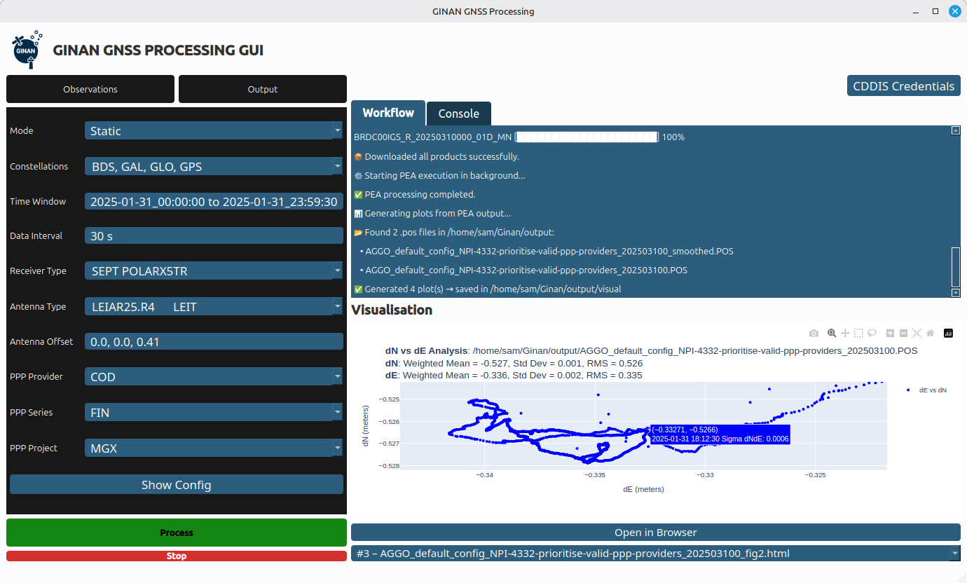
Version 4 features a new intuitive graphical user interface (GUI) that makes data processing faster, easier and more accessible. The new GUI was designed to lower the barrier to entry for users across sectors. With simple data loading and streamlined output downloads, the new interface enables anyone — from navigation specialists to disaster response teams — to harness centimeter-level accuracy without needing advanced technical expertise.
Ginan V4 also introduces enhanced robustness and improved software formatting, reducing errors and accelerating processing speeds. Users can expect smoother workflows and reliable results, whether calculating orbital mechanics or pinpointing precise locations on Earth’s surface.
Ginan V4 remains fully modular, empowering users to build their own capabilities depending on their needs. From surveying and geospatial analysis to emergency response and scientific research, the toolkit supports innovation across diverse applications.
Key benefits of Ginan V4
User-friendly interface. Simplifies data loading and output generation.
Enhanced robustness and speed. Fewer errors, faster processing.
Modular design. Customize capabilities for orbital mechanics, surveying or disaster response.
GNSS accuracy. Centimeter-level precision based on satellite observations.
Free and open source. Available to download via Geoscience Australia’s GitHub.
As part of Positioning Australia’s suite of capabilities, Ginan V4 reflects Geoscience Australia’s commitment to delivering GNSS capabilities that support innovation, safety and productivity. By making the software free and open source, the program ensures that Australian expertise continues to drive global advances in positioning technology.
Ginan V4 is available for free download on Geoscience Australia’s GitHub. More information can be found at ga.gov.au/positioning.
FrontierSI has signed a collaborative agreement with Geoscience Australia, Curtin University and the University of Newcastle to enhance Ginan with features specifically aimed at supporting low-Earth orbit (LEO) satellites as an important component of Geoscience Australia’s Positioning Australia program.
Ginan is Geoscience Australia’s GNSS analysis center software. It delivers a real-time positioning correction service through open-source software and additional positioning products to enable precise point positioning for Australian industry and users.
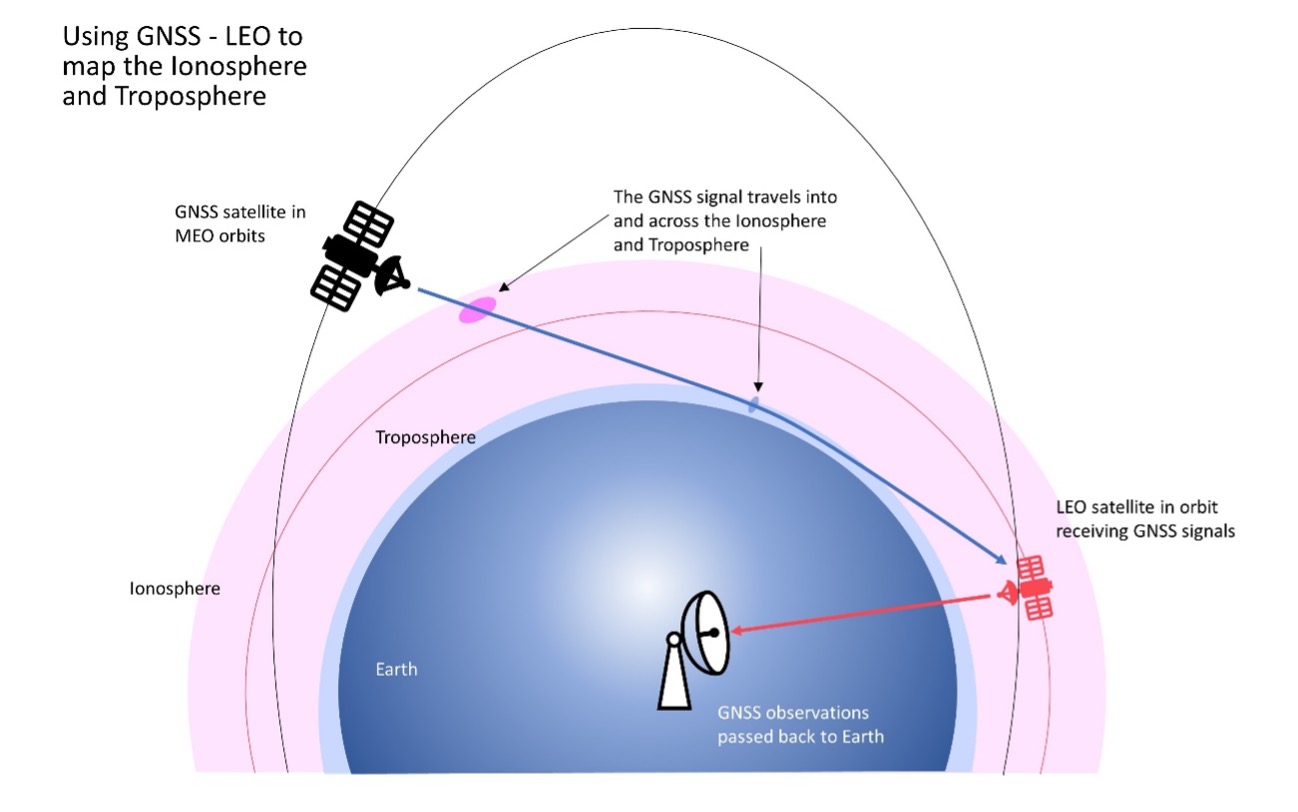
The design, development and deployment of LEO satellites has grown significantly over the last decade. The agreement with FrontierSI complements ongoing Ginan precise orbit determination (POD) development activities, focusing on the implementation of LEO satellite modeling and the orbit integrator/propagator capabilities needed to enable LEO GNSS data to be processed and high-precision LEO satellite trajectories estimated and predicted.
Such a capability will enable:
better monitoring of LEO satellites for station keeping, collision avoidance and end-of-life purposes
improved ionosphere and troposphere monitoring and modeling through the analysis of GNSS signal occultation, to provide data for weather prediction and precise positioning purposes.
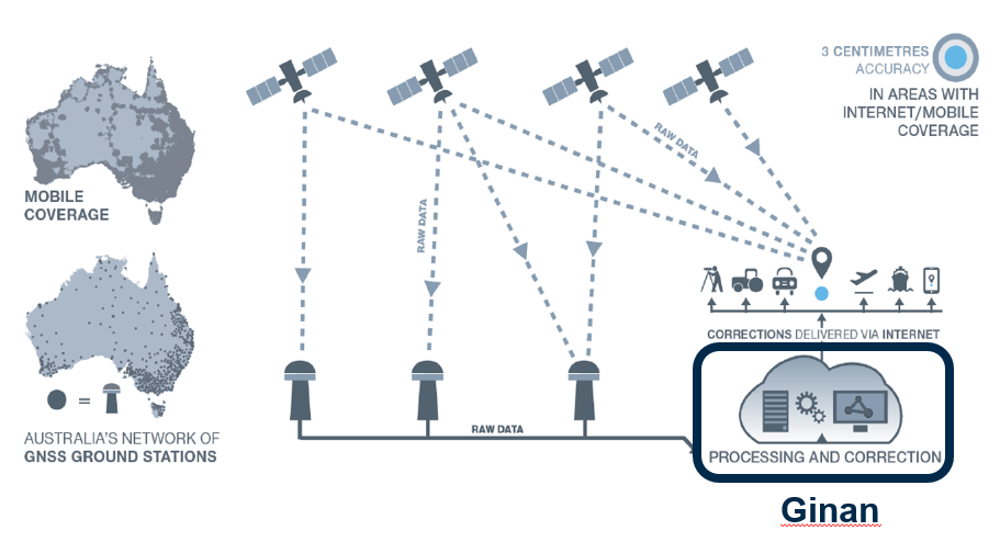
Geoscience Australia is developing open-source software — named Ginan — that will provide real-time corrections to positioning signals of all the GNSS constellations.
Once operational, Ginan will improve the accuracy of location data from 10 meters down to 3 to 5 centimeters for users with an internet and mobile connection. It will enable industry to provide reliable centimeter positioning to their customers, the agency said in a press release.
“Ginan is part of an exciting and innovative Australian Government program to enable precise positioning technology across the whole of the Australian continent,” said Martine Woolf, head of Geoscience Australia’s National Positioning Infrastructure Branch. “It will provide industry with the ability to use precise point positioning, bringing significant economic and social benefits to Australia.”
Examples of how this data could be used include reducing fertilizer and chemical spray waste in agriculture. It could also improve the operational efficiency of large mine sites through greater use of automation.
“Ginan will allow Australians to enjoy the benefits of precise positioning through the creation of new services and products, and in doing so, drive Australia’s economic growth,” Woolf said. “Our precise location data will inform of near real-time atmospheric conditions, which is already being used by the Bureau of Meteorology to assist with their weather predictions. It will also enable a greater understanding of movements in the Earth’s crust and provide insight into earthquakes, sea-level changes and the atmosphere.”
Ginan 1.0 will be publicly released in June 2022. An alpha version is now available on the Ginan GitHub repository, with a beta version planned for user testing from February 2022.
Ginan concept overview. This diagram illustrates how Australia’s network of GNSS ground station infrastructure streams GNSS satellite observations for Ginan to process and analyze, providing correction data to users through an internet connection. (Diagram: Geoscience Australia)
A thoughtful name
Ginan is named for a star that aided the First Australians as they navigated across the continent.
Woolf said the name of the software is a gift from the Wardaman people from the Northern Territory. Geoscience Australia sought permission to use the name Ginan as part of its commitment to respectfully engage and collaborate with Australia’s First Peoples.
“In the language of the Wardaman people, Ginan means ‘a red dilly-bag filled with songs of knowledge’. We like to think of this software as being similar to a dilly-bag full of knowledge because of the benefits it will unlock,” Woolf said. “Ginan is also the name of the fifth-brightest star in the Southern Cross. Just as the Southern Cross helped the First Australians to navigate this land, the positioning capability we are developing here at Geoscience Australia will enable us to know exactly where we are and where we are going.”
Wardaman Elder Diganbal Rosas said the dilly-bag was an important part of the Wardaman songline of the Katherine region. Songlines help to culturally and physically map land and seas through the transmission of traditional knowledge, cultural values, lore and wisdom across the landscapes. They are a living ancient memory code linking the environment, language and culture.
“Ginan [in our language] has all of the Wardaman knowledge regarding connection to country — all of the stars, the skies, the country, the people and the kinship. Everything we do is held in that dilly-bag, in that Ginan,” Rosas said. “The star teaches us many aspects of that spiritual connection to country, how it all began through those songlines, and how that story connects country to the stars. It is significant [that the Wardaman people have allowed Geoscience Australia to use this name] and I think it is a great opportunity for us to showcase our partnership.”
The Ginan initiative is part of Geoscience Australia’s Positioning Australia program, which is improving the accuracy of location-based data across the nation, bringing it from meters to centimeters.