Tag: GIS software

  • NV5 Geospatial releases cloud-based geospatial data management platform

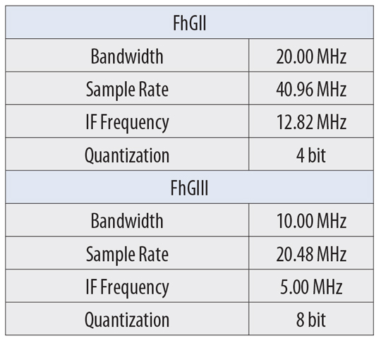
    NV5 Geospatial, powered by Quantum Spatial, has launched INSITE, a comprehensive cloud-based platform that enables users to more efficiently and cost-effectively manage their geospatial data, from acquisition to delivery.

    With applications designed for electric utilities and telecommunications, as well as federal, state and local governments, INSITE provides tools to support the entire geospatial data lifecycle, including project tracking, data collection and delivery, quality control, on-demand reporting, analytics and enterprise integration, the company said.

    Screenshot: NV5 Geospatial
    Screenshot: NV5 Geospatial

    INSITE also enables users to import, search, analyze, manage, integrate and export all types of geospatial data and multimedia. According to NV5 Geospatial, as a cloud-based platform, INSITE improves speed and efficiency, minimizes storage expenses and supports greater collaboration by eliminating the use of standalone hard drives or a dedicated computer.

    “Location-based data is critical for business and governments when it comes to managing risk, lowering costs, forecasting work and maintaining compliance,” said Mark Abatto, president and COO of NV5 Geospatial. “Yet there are numerous technical and organizational barriers that prevent them from optimizing use of this information. INSITE was purpose-built to break down these barriers, creating a single source of truth for all geospatial data within an organization. Now, with INSITE, distributed teams can collaborate more effectively, visualize data with ease and gain real-time insights through powerful analytics.”

    According to the company, the INSITE platform is the foundation of three primary categories of use: the INSITE Lifecycle, INSITE Core, and INSITE Facility and Pole Manager.INSITE Lifecycle provides visibility into project status through a web-based map with real-time tracking of data from acquisition through processing and delivery, while INSITE Core enables data visualization and interaction, including access to aerial imagery, lidar data, GIS layers, and more. Lastly, INSITE provides the basis for industry-specific applications, including INSITE Facility and INSITE Pole Manager. INSITE Facility provides configurable asset management, including planning, execution and tracking for inspections and maintenance on any asset and facility, and INSITE Pole Manager enables electric utilities to take advantage of automated pole modeling analytics that support joint use, clearance and integrity analysis programs.

    NV5 Geospatial will host a live launch webinar on Feb. 18 to provide an overview of INSITE. Register for the webinar here.

  • TCarta unveils Global Satellite Derived Bathymetry product line

    Image: TCarta
    Image: TCarta

    TCarta Marine has introduced a Global Satellite Derived Bathymetry (G-SDB) product line developed with a new seafloor depth measurement technique that leverages Machine Learning and NASA ICESat-2 laser data. According to the company, this G-SDB offering covers the entire Red Sea, with additional sets rolled out through the end of this year.

    The commercial TCarta G-SDB data sets and the seafloor measurement workflow that produces them were made possible through a Small Business Innovation Research Grant from the National Science Foundation (NSF).

    According to TCarta, G-SDB data sets contain bathymetric measurements to depths of more than 30 meters, depending on water clarity, at 10-meter resolution. The depth values for every 10-meter pixel are the combined result of numerous measurements, resulting in accuracy within 10% of depth or less, and providing a seamless water bottom surface map. G-SDB will be available globally for all oceans and seas, as well as large freshwater lakes where water conditions permit.

    “The new satellite-derived bathymetry technology extracts seafloor measurements by integrating multiple SDB algorithms and sensor types at scale and over broad geographic areas with a degree of confidence in data accuracy not previously possible,” said TCarta president Kyle Goodrich.

    TCarta launched Project Trident with NSF funding in 2018 with the goal of refining traditional satellite-derived bathymetry technology to extend its application into areas where it had not typically been successful, usually due to the turbidity or clarity of the water column. TCarta developed the new method using machine learning to iteratively evaluate Sentinel 2A/B multispectral satellite images, and even individual pixels within images, to select the sharpest and clearest ones for application of SDB extraction.

    “Thanks to the power and speed of cloud computing, we run the extraction algorithm repeatedly and on multiple satellite images acquired over the same geographic area on different dates. This dramatically increased the accuracy confidence in each depth measurement and minimizes data gaps,” Goodrich said.

    To further enhance the accuracy of the SDB measurements, TCarta developed an artificial intelligence-based technique for leveraging ICESat-2 data to train the SDB algorithm and validate results. Designed for polar ice elevation and tree canopy measurements, the ICESat-2 satellite carries a laser that captures remarkably accurate bathymetric data, the company said.

    TCarta Marine is a global provider of hydrospatial solutions. The TCarta product lines include high-resolution satellite-derived water depth and seafloor map products as well as 90- and 30-meter GIS-ready bathymetric data aggregated from numerous information sources.

  • IQGeo software company acquires OSPInsight for fiber optics

    IQGeo software company acquires OSPInsight for fiber optics

    logoIQGeo, a developer of geospatial productivity and collaboration software for the telecoms and utility industries, has acquired OSPInsight International Inc., a U.S.-based leader in fiber-optic network management.

    Under the terms of the agreement, IQGeo will purchase OSPInsight for $8.75 million, which will be funded through a mix of cash and shares. The completion of the acquisition is subject to shareholder final approval.

    The OSPInsight fiber planning and design software for the telecoms market is highly complementary with IQGeo’s geospatial software that also supports telecoms network operations, according to a press release from IQGeo. While the current IQGeo offering targets larger enterprise network deployments (tier 1 and tier 2 operators), the OSPInsight software is ideally suited for the needs of smaller networks (tier 3 and tier 4 operators) with simple, fast deployments.

    The combination of the two product lines, as well as the telecoms industry and software technology expertise, will enable IQGeo to service an expanded target market in existing and new geographies.

    “The entire IQGeo team is very excited about the business and technology potential that will be created by the acquisition of OSPInsight,” said Richard Petti, CEO at IQGeo. “With more than 25 years of industry experience, they have developed an excellent product line and established an impressive list of customers, while building a very strong reputation in the telecoms industry. We see this as a fantastic opportunity that provides IQGeo with a proven software solution and sales channel for tier 3 and tier 4 network operators and it gives the OSPInsight team the global reach and financial resources needed to take their software to a wider audience.”

    “The real winner in this acquisition will be OSPInsight customers,” explained Wade Anderson, CEO at OSPInsight. “Our customers will continue to enjoy the same level of support they’ve always had and have a greatly expanded product line for additional network management solutions. Existing and future OSPInsight customers will quickly have access to IQGeo’s industry-leading mobile software that digitizes field operations to improve network data quality and currency. The two product lines dovetail very nicely. I’m excited for the shared vision of providing world-class software that helps our telecoms customers transform their network operations. We can’t wait to get started.”

    You can learn more about the acquisition by visiting the IQGeo Investor page to view a video interview with Richard Petti, IQGeo’s CEO and Haywood Chapman, IQGeo’s CFO.

  • Comment sought on OGC API standard for geospatial web processing

    Comment sought on OGC API standard for geospatial web processing

    New process simplifies task of computational geospatial processing accessible via web services

    OGC logoThe Open Geospatial Consortium (OGC) seeks public comment on a new draft OGC API standard: OGC API – Processes – Part 1: Core. Comments are due by Oct. 19.

    The draft OGC API – Processes Standard specifies a Web API that enables the execution of computing processes and the retrieval of metadata describing their purpose and functionality. For example, these processes could combine raster, vector, coverage and/or point cloud data with well-defined algorithms to produce new raster, vector, coverage and/or point cloud information.

    The draft OGC API – Processes Standard builds on the Web Processing Service (WPS) 2.0 standard and defines the processing standards to communicate in a RESTful manner using JSON encodings. This API is a newer and more modern way of programming and interacting with resources over the web while allowing better integration into existing software packages.

    In many cases, location data, including data from sensors, must be processed before the information can be effectively used. OGC API – Processes, just like the OGC WPS Interface Standard, provides a standard interface that simplifies the task of making simple or complex computational geospatial processing services accessible via web services.

    Such services include well-known processes found in GIS software as well as specialized processes for 2D/3D/4D modeling and simulation. The API also makes it easy for developers to implement microservices that can handle location data.

    The draft OGC API – Processes Standard provides a similarly robust, interoperable, and versatile protocol for process execution across the Web. OGC API – Processes supports both immediate processing for computational tasks that take little time and asynchronous processing for more complex and time-consuming tasks.

    As with other OGC APIs, OGC API – Processes consists of optional parts that each provide extra functionality. This specification, Part 1: Core, is intended to be a minimal useful API for the execution of processes from the geospatial domain. There are no constraints on the types of processes that can be published through the API. Examples of processes that have been demonstrated during the development of the draft API standard include routing, contour generation, buffering, coverage processing and several others. The API is therefore expected to be applicable to several domains.

    The candidate OGC API – Processes – Part 1: Core standard is available for review and comment on the OGC Portal. Comments are due by October 19, 2020, and should be submitted via the method outlined on the OGC API – Processes – Part 1: Core draft Standard’s public comment request page.

  • Global Mapper v22 has 3D eye dome lighting and lidar painting

    Global Mapper v22 has 3D eye dome lighting and lidar painting

    Terrain Painting in Global Mapper v22. (Image: Blue Marble)
    Terrain Painting in Global Mapper v22. (Image: Blue Marble)

    Blue Marble Geographics has released version 22 of Global Mapper along with an upgrade to the accompanying Lidar Module.

    Global Mapper GIS software provides both novice and experienced geospatial professionals with a comprehensive array of spatial data processing tools, with access to a variety of data formats.

    Among other features, Version 22 includes

    • Eye Dome Lighting settings in the 3D viewer to help improve the visual display of vector and lidar data
    • a new tool for simplifying meshes or TINs
    • a new Spatial Operations tool for analyzing the relationship between overlapping vector features
    • a new option to measure the overlap between two or more lidar, raster/image and terrain layers
    • a new consolidated Digitizer Menu providing convenient access to all drawing and digitizing tools

    The Lidar Module, an optional add-on to Global Mapper, provides advanced point cloud processing tools, including Pixels to Points for photogrammetric point cloud creation using overlapping drone-captured images, automatic and manual point cloud classification, feature extraction, hydro-flattening, and more.

    Terrain Paint tool. The upgraded Lidar Module includes a new Terrain Paint tool for manipulating elevation values in a freeform way, a new algorithm to improve building classification results, improved building extraction with better 3D shape simplification for generating building footprints, a new option to create a process summary report when using the Pixels to Points process, dramatically faster rendering of lidar path profiles with a large number of points, and more.

    “The version 22 release illustrates Global Mapper’s rapidly expanding geospatial footprint,” stated Blue Marble’s President, Patrick Cunningham. “In this one release cycle, we have introduced countless new tools for GIS analysis.Global Mapper is truly an accessible yet powerful GIS platform. As always, we are pleased to be able to bring all of these capabilities together in one GIS platform while keeping the price affordable.”

    Blue Marble Application Specialists will hold a webinar Sept. 30 to showcase Global Mapper v22. This presentation is scheduled to begin at 2:00 pm (U.S. Eastern Time), and it will allow attendees to see the latest tools and ask questions about the new functionality. Registration is required.

  • MGISS accredited for UK government procurement, utility sector

    MGISS accredited for UK government procurement, utility sector

    MGISS logo

    Mobile GIS Services (MGISS) has been awarded a place on the United Kingdom government’s procurement platform G-Cloud.

    Designed to ease the procurement of cloud services by the public sector, the G-Cloud 12 framework makes it easier for customers to find, review and contract MGISS’s advanced geospatial software services through an online digital marketplace. Managed by Crown Commercial Services, it is forecast that successful suppliers, such as MGISS, will receive up to £2 billion in business.

    In a parallel achievement, MGISS has also been accredited as a supplier of software, hardware and support services to the utility sector by the supplier assurance company Achilles.

    A specialist in mapping and geographic information technology, MGISS also is working alongside organizations such as United Utilities and Northumbrian Water Group and it is hoped that successful qualification under the Achilles UVDB pre-qualification system will help MGISS gain further traction within this sector.

    MGISS has also attained the Workplace Wellbeing Charter. Recognizing a commitment to improving the lives of its team members, MGISS received accreditation across a number of facets including leadership, health and safety, mental health and absence management.

    “Although recognizing completely different aspects of the business these awards are all significant milestones and accomplishments in their own right and the entire team should be proud of the hard work and commitment they have expended to achieve them,” said MGISS Managing Director and Founder Mike Darracott. “The G-Cloud and Achilles accreditation will put MGISS front and center for the leading players within the public and utility sectors and this will help us capitalise on our work to date with organizations such as Surrey County Council and Wales and West Utilities.

    “The Workplace Wellbeing Charter not only recognizes our existing commitment to the health and wellbeing of our team it also gives a benchmark to work from and a toolset to work with to continuously improve,” he continued, “and a happier and healthier workforce will, we hope, make the business even better and stronger.”

  • GIS helps telecom industry meet new demands

    Image: nadla/E+/Getty Images
    Image: nadla/E+/Getty Images

    By Akshita Pacholi
    Allied Market Research

    With advantages provided by geographic information systems (GIS), the demand for GIS in the telecom industry has increased in recent years. According to a report published by Allied Market Research, the global telecom market is anticipated to garner $3.27 million by 2023.

    GIS has fortified the telecom industry by reducing costs and augmenting capital planning. GIS mapping can improve outage prediction, resource management and infrastructure determination.

    GIS also can help the emerging economies for independent energy, efficient infrastructure, and enhanced communication systems. GIS provides imagery, geocoding, modeling, routing and the required data for these applications.

    GIS is rising in popularity as it eases access to critical sources of business intelligence.

    Impacts in the telecom industry

    GIS mapping supports telecom companies with factors such as enhanced customer service with location data and imagery, efficient resource dispatch, and prompt sharing of location data. This enables telecom industries to track locations and have a better understanding of service layout.

    GIS mapping lets companies know the geospatial relationships of their facilities, resources and ground features, and provide faster and more effective customer service.

    GIS also helps identify faulty circuits. It can help model the solution online and offer best-case scenarios, resulting in improved operations and enhanced customer service.

    GIS mapping also helps the sales and service team understand their targets by tracking multiple layers of geospatial data and providing insight into the customer base.

    Information on network structure

    Almost every telecom company focuses on offering effective, functioning networks, along with network monitoring, testing of network elements, maintenance and customer services. The real-time network structure offered by GIS solutions enhances these monitoring and service activities.

    With GIS, networks get instant access to information such as customers’ history and rank, current network structure, signal quality in precise demography, and any need for maintenance or restoration of services. Moreover, GIS makes the services more reliable and fast.

    GIS solutions are also beneficial for determining market demand for future estimations. GIS offers a better understanding of the relationship between customers’ topographical presence and companies’ marketing operations. It helps companies identify networking issues and easily reach customers, along with offering information on other issues.

    With its precise geography, GIS helps telecom companies meet service demand and develop budgets for promotional activities and marketing campaigns.

    Enhancing telecom services

    With computers and mobile devices a necessity for most of us, many telecoms want to expand to provide services in rural areas — a major reason for their adoption of GIS.

    Another motivator is the surge in demand for augmented reality and virtual reality, part of the increase in the adoption of GIS for mobile and broadband services.

    Smart Cities. GIS provides a platform that works with Customer Relationship Management (CRM) systems, networks, databases, fault management system and wireless location. The demand for growth also depends on the rise in demand for satellite images by companies that provide maps and an increase in government spending to develop and build smart cities.

    Moreover, the rising use of technology, the internet, and other digital platforms in rural areas has sparked companies to expand their services.

    With companies focusing on broad network coverage, greater connectivity and emerging innovations such as 5G, the field of mobile telecommunications technology is anticipating opportunities to expand market growth.


    Akshita Pacholi has a master’s degree in English literature and is working as a content writer with Allied Market Research. 

  • Enview unveils 3D AI as a web application, Enview Explore

    Enview unveils 3D AI as a web application, Enview Explore

    Screenshot: Enview
    Screenshot: Enview

    Application empowers users with expert visualization and analysis of lidar

    Enview, a pioneer in the scalable processing of 3D geospatial data, has launched Enview Explore, a powerful web application that leverages artificial intelligence (AI) and cloud computing to automatically process 3D data at a high speed and scale.

    Also, Robert Cardillo, former director of the National Geospatial-Intelligence Agency (NGA), has joined the company’s board of directors. Following an oversubscribed round of funding in May, the company continues to experience growth and momentum in the market.

    Enview’s technology has been deployed on thousands of square miles worldwide to protect vital infrastructure and support mission-critical operations. Its unique method for classifying 3D data using neural networks and deep learning techniques reduces time to action by focusing on finding meaningful insights in 3D data.

    Previously offered as custom services for organizations such as Pacific Gas & Electric and the United States Air Force, this groundbreaking technology is now available for the first time as an easy-to-use, self-service web application.

    Screenshot: Enview
    Screenshot: Enview

    “Enview has built the world’s most scalable AI platform for transforming 3D point clouds into insight and action,” said San Gunawardana, Ph.D., co-founder and CEO of Enview. “We are solving one of the hardest problems in machine perception, and applying it to some of the most grounded and impactful challenges facing society. It is our goal to empower people with the confidence to perceive and navigate a rapidly changing world; Enview Explore is the natural next step in this journey and our team is excited to place this groundbreaking capability directly into the hands of operational end-users.”

    Key benefits of Enview Explore include:

    The power of 3D data. Three-dimensional unstructured data, such as lidar, contains incredible detail but is painfully slow to analyze manually. Enview solves this problem by combining its novel AI with the power of cloud computing to automate 3D classification and segmentation, giving users scalability that can support even nation-sized datasets.

    High speed. While current methods can take weeks or more to process data, Enview provides actionable insights in minutes. Enview Explore utilizes a new and innovative approach that applies AI to 3D data, yielding significantly faster results than traditional lidar software.

    Total data control. Enview Explore removes the need for outsourcing lidar to a third party by giving users the ability to perform classification, segmentation, terrain modeling, change detection, feature extraction, and intuitive visualization directly inside the application.

    Screenshot: Enview
    Screenshot: Enview

    “With this release, we wanted to show the world that you don’t need to be a professional to get expert analysis from lidar,” said Anthony Calamito, VP of Products for Enview. “Lidar and other 3D data hold tremendous value and provide unparalleled insight over 2D data sources. While unlocking that value traditionally has required an in-depth understanding of specialty software, Enview Explore lets anyone create meaningful insight from 3D data with just a few clicks.“

    The company also announced that Robert Cardillo has joined its Board of Directors. Cardillo served as the sixth director of the NGA from 2014 through 2019. In that position, he led the NGA under the authorities of the secretary of defense and director of National Intelligence to transform the agency’s future value proposition through innovative partnerships with the growing commercial geospatial industry.

    “Mapping the world in 3D opens new possibilities for national security and mission-critical infrastructure, including some of the most important challenges facing our nation today,” said Cardillo. “Enview has completely changed the game when it comes to what’s possible with lidar visualization and analysis, making unstructured data accessible and easy to use: in other words, creating coherence out of chaos. With a shared purpose and commitment, I look forward to working with the Enview team toward the future the world demands and our customers deserve.”

  • 1Spatial becomes corporate member of DAMA UK, releases software upgrades

    1Spatial becomes corporate member of DAMA UK, releases software upgrades

    Logo: 1Spatial

    1Spatial has released a number of updates, including its membership in the Data Management Association (DAMA) UK and two software updates.

    DAMA UK membership

    1Spatial is now a member of DAMA, a global community of data management professionals organized around local membership-based chapters. The chapters are supported by DAMA International, which maintains the data management body of knowledge and the certified data management professional certification. DAMA UK is a local chapter that aims to nurture a community of data professionals in the U.K. who champion the value of data management.

    1Integrate v2.7

    1Spatial has unveiled 1Integrate v2.7, which the company says ensures compliance of data for use across the enterprise and provides automated data validation, cleaning, transformation and enhancement. It also enables users to access the quality of data to ensure it meets defined specifications and is fit for purpose.

    This release adds support for Esri feature services via a connection to the ArcGIS server, enhanced security features and the ability to define custom task labels. It’s also able to toggle groups of indexes for improved efficiency when configuring data stores, as well as provide simple integration wit lightweight directory access protocol for WEbLogic installations. It features custom task labels, updated platform support and a clearer view of available datastores if FME is not being utilized alongside 1Integrate.

    “We have focused our improvements on data access, with the ability to connect to Esri ArcGIS Server essential as many of our customers are moving to SaaS offerings,” said Sarah Gadd, 1Integrate product manager. “We have also made improvements in usability, with the new custom tasks labels making even the most complex sessions easier to read and maintain. Our platform refresh means we can deliver the latest security enhancements, and by further expanding our datastore support we can offer customers even more options for data validation and enhancement.”

    1Data Gateway v2.1

    1Spatial also has released 1Data Gateway v2.1. According to the company, 1Data Gateway is a web-based portal for spatial data validation, processing and analytics. It provides a simple and controlled way to deliver validation rules, corrections and data enhancement processes for users with no training required and can be deployed on the cloud or on-premise, the company added.

    1Data Gateway (Image: 1Spatial)
    1Data Gateway (Image: 1Spatial)

    The release includes a variety of new features, including the introduction of conformance thresholds which enable the automatic rejection of submissions, giving customers more control over validation of their data. It also includes support for 1Integrate 2.7, user interface and washboarding improvements, support for missing features and attributes, task conformance pass thresholds, improved schema mapping management, media retention policies, more granularity in user permissions and export statistics in CSV format.

    “1Data Gateway is successfully serving large governmental and private agencies, helping them to ensure the quality of incoming data from supply chains is as they would expect,” said Ricardo Cifres, 1Data Gateway product manager. “With this new release we can deliver even more flexibility and security, improving our customer’s data governance processes even further.”

  • Blue Marble releases Global Mapper Mobile v2.1 with advanced GPS support

    Image: Blue Marble
    Image: Blue Marble Geographics

    Blue Marble Geographics has released version 2.1 of its mobile mapping application Global Mapper Mobile, with updates to both the free and Pro versions.

    Global Mapper Mobile is an iOS and Android application for viewing and collecting GIS data. It utilizes the GPS capabilities of mobile devices to provide situational awareness and locational intelligence for remote mapping projects.

    A complement to the desktop version of Global Mapper, the mobile edition can display all of the supported vector, raster, and elevation data formats and offers a powerful and efficient data collection tool. The latest release includes improvements to its vector feature styling, terrain layer support, and layer transparency setting.

    For advanced field mapping functionality, the latest release of the optional Pro version (available for purchase) introduces advanced GPS support. This allows users to connect to external, high-accuracy Bluetooth GPS devices from vendors such as Bad Elf and EOS, among others, directly from Global Mapper Mobile, allowing users to access detailed information including the current satellite constellation, precise location information and the raw NMEA stream.

    “Global Mapper Mobile v2.1 brings exciting new functionality to the application, much of which was highly driven by user requests and feedback,” said Jeffrey Hatzel, senior application specialist at Blue Marble Geographics.

    Blue Marble’s GIS software is used by hundreds of thousands of satisfied customers throughout the world who need affordable, user-friendly, yet powerful GIS solutions. Users come from a wide range of industries including software, oil and gas, mining, civil engineering, surveying, and technology companies, as well as government departments and academic institutions.

    Visit the website to learn more and download Global Mapper Mobile v.2.1.

  • UP42 partners with Vultus for precision ag solutions

    UP42 partners with Vultus for precision ag solutions

    Photo: UP42
    Photo: UP42

    UP42 has partnered with Vultus, which specializes in precision farming technologies.

    According to UP42, its customers can now use Vultus Fertilization Zoning Maps algorithms to fine-tune crop management — with more agricultural technologies coming soon.

    Founded in 2016 in Lund, Sweden, Vultus AB provides a geospatial infrastructure for precision farming. Vultus analyzes Earth observation satellite data with advanced artificial intelligence algorithms to give farmers insights into the health of crops within small sections of their fields, enabling them to apply fertilizers variably across the field.

    “Growers reduce nitrogen-based fertilizer use by up to one third while increasing yield by three to five percent with the Vultus technology,” said Robert Schmitt, Vultus CEO. “This results in lower operating costs and significantly less environmental harm.”

    Fertilization Zoning Maps — the first in a series of proprietary algorithms Vultus brings to UP42 as a partner — shows farmers which parts of their fields need more or less fertilizer. Fertilization Zoning Maps divide fields into five zones that are classified according to the variable fertilization rate the soil requires, Vultus said.

    By partnering with Vultus, UP42 also brings precision farming technologies to the users of its geospatial developer platform and marketplace for Earth observation data and analytics. With the addition of Vultus technologies, UP42 customers can now pick and choose combinations of data and processing algorithms for their area of interest and retrieve results on a single scalable platform.

    “We’re very happy to announce a new partnership with Vultus, an emerging leader in the agritech industry,” said Sean Wiid, UP42 CEO. “Our partnership is a key step towards providing UP42 users with a simplified way of building precision agriculture solutions. We look forward to launching new capabilities and supporting the agritech industry together.”

  • Touch GIS app introduces digital clinometer tool for geologists

    Touch GIS app introduces digital clinometer tool for geologists

    The new digital clinometer and attitude attribute type available in Touch GIS. (Image: TouchGIS)
    The new digital clinometer and attitude attribute type available in Touch GIS. (Image: Touch GIS)

    Touch GIS has introduced a digital clinometer tool to assist field geologists in recording strike and dip readings.

    Version 1.3 of the app also features a new “attitude” attribute type, which makes it easy to record and display these readings on the map.

    “We’ve been testing these new features with a number of field geologists, and we’re excited to finally be launching it broadly,” said Joe Wilson, head of products at Touch GIS. “While Touch GIS is valuable for a wide variety of field data collection, we’ve found that it’s especially popular with geologists.”

    As more and more field work is being done on mobile devices, it’s important to integrate them onto a single platform for collecting and sharing field data. Touch GIS has a mission to provide the most robust data collection featureset for mobile field mapping.

    Touch GIS also features powerful file support for industry-standard types, offline mapping capabilities, and accurate drawing tools for points, lines and polygons.

    Touch GIS has a free tier that allows users to explore a majority of its features. Premium subscribers can cache maps for offline use and export collected data.

    The app is available free for download on the Apple Store.