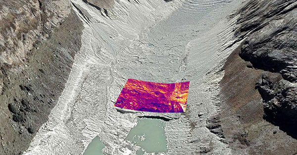
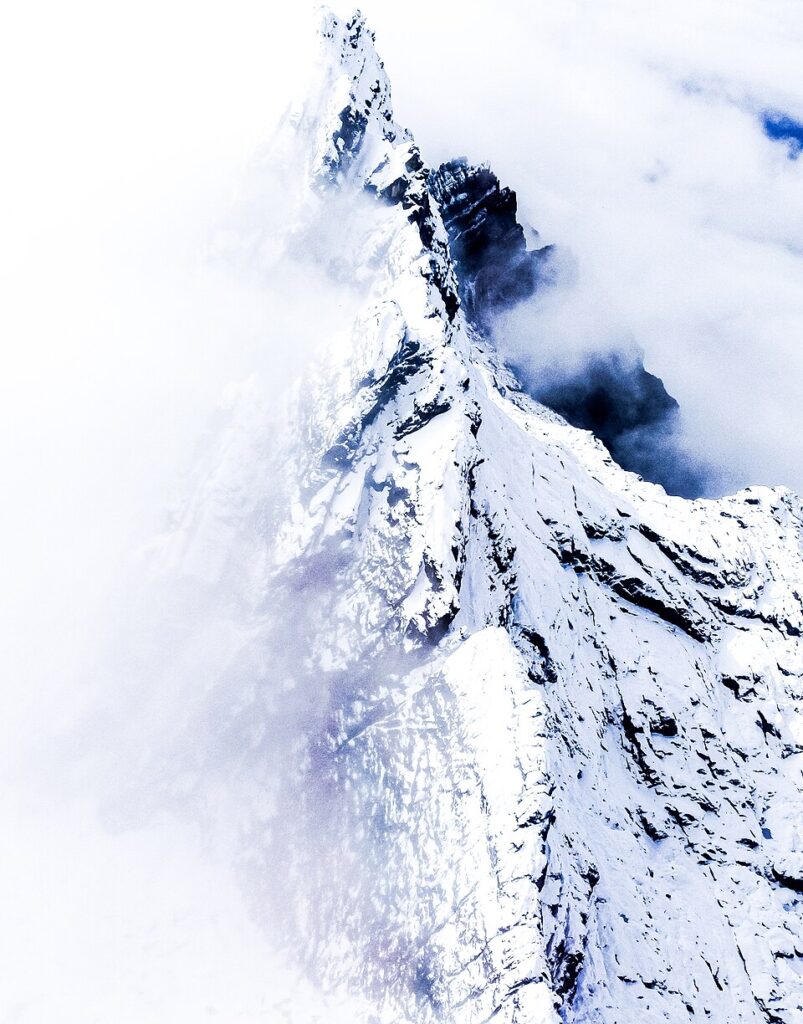
Data provides baseline measurement for tracking change at one of Earth’s last tropical ice fields in Puncak Jaya, Papua, Indonesia.
Trimble is supporting Project Pressure by providing advanced GNSS positioning technology and research funding for the nonprofit organization’s latest expedition to map the disappearing tropical glaciers of Puncak Jaya in Papua, Indonesia.
Project Pressure has released a centimeter-accurate, 3D model of the receding ice, created using Trimble positioning technology and drone-based photogrammetry. The model establishes a scientific baseline for calculating the rate of glacier recession and projecting the timeline of disappearance.
Puncak Jaya, the highest peak in Oceania and one of the Seven Summits, is expected to be the first of the seven continental peaks to lose its glaciers as global temperatures rise.
Local communities use the data to make informed choices about crop selection and prepare for expected water shortages caused by the loss of vital reservoirs.
This expedition marks the third successful outing in Project Pressure’s “Melting Topics” series, which focuses on mapping equatorial glaciers. Trimble provides its GNSS mapping technology and research funding from the Trimble Foundation Fund to support Project Pressure in gathering critical data in some of the world’s most remote and hostile environments.
“Mapping these glaciers before they disappear is of critical importance to establish a baseline to track the glacial regression and for the local communities to understand what is happening with their water source, allowing them to adapt to a changing climate,” said Eliot Jones, senior manager, strategy and partner development at Trimble. “Through a combination of precision technology, detailed project planning and rigorous science, the models created by Project Pressure are shared for scientific study and provide a visual reference for future generations.”
Precision under pressure in hostile terrain
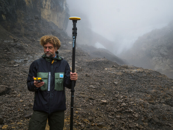
Mapping glaciers at altitudes exceeding 4,800 meters (15,000 feet) presents extreme logistical and environmental challenges. Near-constant cloud cover and heavy rainfall in Papua often render satellite imagery unusable, making ground-based georeferencing essential.
The expedition team installed precise geolocation reference points directly on the glacial surface at multiple locations. Using the Trimble Catalyst DA2 GNSS system and Trimble TDC600 handheld, researchers captured the exact coordinates of those points with centimeter-level accuracy. Drone imagery was then processed against the Trimble coordinates to produce a scientifically reliable 3D model of the glacier.
“Trimble makes incredibly complex technology feel simple in the field,” said Klaus Thymann, scientist and lead explorer. “When you’re standing on a glacier in freezing conditions, wearing thick gloves and surrounded by clouds, you don’t have time to fight with equipment. With Trimble, I can capture centimeter-accurate readings and the interface is so intuitive that even someone with no prior training can help collect data. That kind of reliability and simplicity is critical when you’re working in some of the most remote and challenging environments in the world.”
This approach builds on methods developed during Project Pressure’s 2024 expedition to the Rwenzori Mountains in Uganda, which also used Trimble technology.
The lightweight Trimble Catalyst DA2 GNSS system was critical for the expedition, which required helicopter access to Basecamp, followed by a trek to the launch point.