Tag: Global Mapper Mobile

  • Global Mapper Mobile expands GNSS device communication

    Global Mapper Mobile expands GNSS device communication

    Global Mapper Mobile version 2.3 with the Pro Module expands GNSS compatibility with TCP/IP communication and includes new field analysis tools

    Photo: Blue Marble Geographics
    Photo: Blue Marble Geographics

    Blue Marble Geographics has announced that Global Mapper Mobile version 2.3 provides additional options for connecting with GNSS receivers.

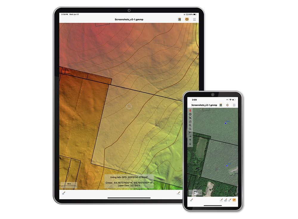
    The Global Mapper Mobile Pro Module has always included the ability to connect to external GPS devices, but version 2.3 expands this to include support for any GNSS device that uses TCP/IP communication. Additionally, this mobile update provides Global Mapper analysis tools for volume calculation and viewshed for terrain data.

    The mobile application of Global Mapper allows users to take the desktop functionality and existing data into the field for easy and accurate data collection and light processing. Since 2016, Global Mapper Mobile has been a user-friendly tool for capturing field data with portable iOS and Android mobile devices.

    Version 2.3, available in both the free and Pro versions, adds many updates and improvements to the application, including the option to record and save voice memos to vector features and add multiple field-captured images to a feature. Autosave now prevents the loss of changes made to a map.

    “Expanding user functionality in the field was the main focus of this release. Users of the base version of the application can utilize voice memos and the ability to save multiple photos to features for a more complete recording of field data,“ said Jeffrey Hatzel, Global Mapper Mobile product manager. “The Pro Module adds TCP/IP communication for external GNSS devices, expanding the list of compatible third-party devices. The addition of tools for volume calculation, viewshed analysis, and expanded projection support allows for even more workflows to be completed within the app.”

  • Blue Marble releases Global Mapper Mobile v2.1 with advanced GPS support

    Image: Blue Marble
    Image: Blue Marble Geographics

    Blue Marble Geographics has released version 2.1 of its mobile mapping application Global Mapper Mobile, with updates to both the free and Pro versions.

    Global Mapper Mobile is an iOS and Android application for viewing and collecting GIS data. It utilizes the GPS capabilities of mobile devices to provide situational awareness and locational intelligence for remote mapping projects.

    A complement to the desktop version of Global Mapper, the mobile edition can display all of the supported vector, raster, and elevation data formats and offers a powerful and efficient data collection tool. The latest release includes improvements to its vector feature styling, terrain layer support, and layer transparency setting.

    For advanced field mapping functionality, the latest release of the optional Pro version (available for purchase) introduces advanced GPS support. This allows users to connect to external, high-accuracy Bluetooth GPS devices from vendors such as Bad Elf and EOS, among others, directly from Global Mapper Mobile, allowing users to access detailed information including the current satellite constellation, precise location information and the raw NMEA stream.

    “Global Mapper Mobile v2.1 brings exciting new functionality to the application, much of which was highly driven by user requests and feedback,” said Jeffrey Hatzel, senior application specialist at Blue Marble Geographics.

    Blue Marble’s GIS software is used by hundreds of thousands of satisfied customers throughout the world who need affordable, user-friendly, yet powerful GIS solutions. Users come from a wide range of industries including software, oil and gas, mining, civil engineering, surveying, and technology companies, as well as government departments and academic institutions.

    Visit the website to learn more and download Global Mapper Mobile v.2.1.

  • Global Mapper app now on NGA’s IGAPP store

    Photo: Blue Marble
    Photo: Blue Marble

    Global Mapper Mobile is now available to U.S. government agencies through the Innovative GEOINT Application Provider Program (IGAPP).

    The mobile app is provided by Blue Marble Geographics.

    Administered by the National Geospatial-Intelligence Agency (NGA), the mission of IGAPP is to streamline the deployment of commercial mobile apps to government personnel by bridging the gap between traditional government contracting procedures and non-traditional businesses.

    Blue Marble’s GIS software is used by hundreds of thousands of mapping professionals throughout the world who need affordable, user-friendly, yet powerful GIS solutions. Users come from a wide range of industries including software, oil and gas, mining, civil engineering, surveying and technology companies, as well as government departments and academic institutions.

    Available on both iOS and Android platforms, Global Mapper Mobile enables remote access to mission-critical geospatial datasets in an easy-to-use application. Used in conjunction with the desktop version of the software, Global Mapper Mobile supports hundreds of GIS data formats — both raster and vector — and offers simple, form-based field data collection and geotagged photo capture.

    To address the specific needs of the geospatial intelligence (GEOINT) community, the IGAPP version of Global Mapper Mobile includes streaming access to online data services and the ability to store downloaded tiles for remote offline use.

    “IGAPP provides mission-relevant, cyber secure mobile apps to warfighters, aviators, mariners and first-responders,” according to John Holcomb, IGAPP program manager at Engility, the NGS’s broker for putting commercial applications into the GEOINT App Store. “The program provides commercial vendors with a rapid, cost effective, path to sell their products. We are thrilled to add the Global Mapper Mobile the store and look forward to getting into the hands of DoD users.”

    “Over the years, the GEOINT community has strongly supported our products and has provided valuable feedback that has helped ensure the functionality of our software is addressing the needs of geo-intelligence,” stated Patrick Cunningham, Blue Marble President. “We are delighted that Global Mapper Mobile is now available through IGAPP and that more and more field personnel now have easy access to this valuable app.”