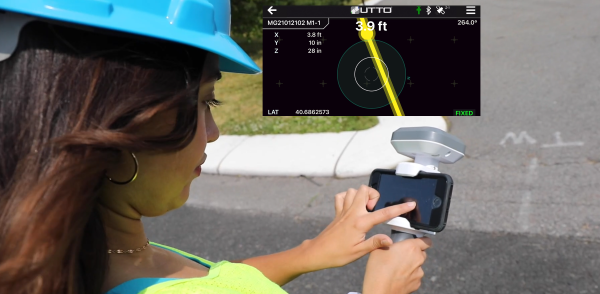
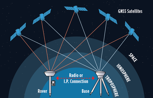
GEODNET, a decentralized real-time kinematic (RTK) network with more than 20,000 active stations worldwide, is now partnering with UTTO, a leading innovator in underground utility mapping and digital damage prevention solutions.
The partnership enables UTTO to leverage GEODNET’s global RTK correction services across its solutions, bringing enhanced centimeter-level accuracy to the utility locating and GIS industries.
UTTO is known for pioneering products such as the vLocate Mapper, which integrates directly with GIS platforms like Esri’s ArcGIS Field Maps to streamline underground asset mapping and verification. By adopting GEODNET’s RTK correction services, UTTO customers gain access to reliable, triple-band GNSS corrections delivered through a uniform, global network. This ensures consistent accuracy across regions and significantly reduces the complexity traditionally associated with GNSS corrections.
The collaboration provides UTTO users with seamless access to GEODNET’s correction services out of the box, eliminating the need for manual RTK configuration and reducing deployment friction for field teams. This simplifies the process of achieving centimeter-level accuracy in mapping underground infrastructure, while maintaining scalability for large utility operators and municipalities.
Key benefits of the partnership include:
Turnkey RTK Access. UTTO devices now integrate directly with GEODNET corrections, requiring no manual RTK setup.
Global Coverage. GEODNET’s network of 20,000+ stations ensures consistent high-precision positioning across multiple regions.
Utility Mapping Optimization. Enhanced accuracy for locating underground assets, reducing strikes and improving field efficiency.
GIS Integration. Seamless compatibility with platforms such as Esri ArcGIS.
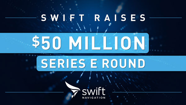
Swift Navigation has completed another funding round to fuel its centimeter-level precision service. The Skylark Precise Positioning Service is a cloud-based service that corrects errors in GNSS signals, improving accuracy to centimeter level and enabling mass-market adoption of applications in autonomous driving, robotics, precision logistics, and V2X communication.
Skylark is a real-time, cloud-based service that meets ISO 26262:2018 functional safety standards for road vehicles. Unlike ASIL-certified positioning solutions that rely on costly physical data centers, Skylark operates entirely in the cloud.
Skylark powers more than 10 million ADAS-enabled and autonomous vehicles worldwide and supports global programs for 20+ automotive OEMs and Tier 1 suppliers, top robotics companies, and a large commercial fleet operator.
This latest financing reflects strong market demand for Swift’s approach to precise positioning. Unlike traditional precise positioning technologies, Skylark leverages advanced atmospheric modeling, cloud-based architecture and carrier-grade networks to deliver unmatched reliability, safety and cost efficiency at scale.
The $50 million Series E financing round was led by Crosslink Capital. The round saw strong participation from existing investors New Enterprise Associates (NEA), Eclipse Ventures, EPIQ Capital Group, First Round Capital, TELUS Global Ventures, and Potentum Partners alongside new investors Niterra Ventures, AlTi Tiedemann Global, GRIDS Capital, Essentia Ventures, Shea Ventures, and EnerTech Capital. This funding brings Swift Navigation’s total capital raised to over $250 million.
One of the most persistent sources of GNSS error — ionospheric delay — has been challenging to correct in real time, especially for mass-market devices. While dual-frequency receivers and commercial correction services can mostly mitigate this issue, they remain too costly and impractical for the billions of smartphones and IoT devices that rely on single-frequency GNSS. Even for dual-frequency systems, the commonly used ionosphere-free linear combination amplifies multipath and receiver errors and reduces data redundancy — yielding only two usable combinations from four original measurements.
This landscape may be shifting with the introduction of GloTEC, a real-time global Total Electron Content (TEC) map from NOAA’s Space Weather Prediction Center (SWPC), released in February 2025. GloTEC assimilates both ground- and space-based observations to provide real-time global ionospheric corrections without relying on error-prone linear combinations.
Unlike coarse models such as the broadcast Klobuchar algorithm or forecast-only products such as the predicted IGS Global Ionosphere Maps, GloTEC updates every 10 minutes using real-time measurements. This high refresh rate establishes a new benchmark for open-access ionospheric nowcasting in GNSS applications.
Originally designed to monitor and mitigate space weather impacts on aviation and communications, GloTEC may also deliver a broader benefit: enabling precise, scalable GNSS corrections for low-cost, single-frequency devices, making high-accuracy positioning more accessible and democratic.
Why Nowcasting Matters for GNSS
The GNSS community has long had to choose between accuracy and latency. Predictive models, such as those from NASA CEDIS or CODETEC, can offer reasonable approximations but may fall short when real-time corrections are required, particularly in the context of navigation, asset tracking or autonomous systems.
Post-processed products (such as rapid/final IGS GIMs) provide excellent fidelity but are typically delayed by hours, days, or even weeks. This makes them useful for research or auditing, but not for real-time navigation needs.
Commercial correction services, such as Trimble RTX and Hexagon’s TerraStar, have filled the gap for high-value applications. These systems interpolate ionospheric corrections in real time, but at a significant cost and they typically require specialized GNSS receivers.
GloTEC bridges this gap by delivering a publicly accessible, high-refresh ionospheric product that can support near real-time corrections. Updated every 10 minutes with a 2.5° latitude and 5° longitude spatial resolution, GloTEC represents a major step forward for public sector GNSS capability, particularly in contexts where accuracy, reliability and scale are all crucial. The data has also been supporting the United States Space Force and is accessible through their Unified Data Library (UDL).
Technical Approach: Adapting GloTEC for Practical Use
While the potential of GloTEC is exciting, turning it into usable corrections for consumer-grade devices isn’t straightforward. TEC maps represent volumetric electron density, while most mass-market GNSS chipsets, especially in smartphones, expect simplified models, such as the eight-parameter Klobuchar model broadcast by GPS satellites. GloTEC is a three-dimensional data assimilation system that uses a Gauss-Markov Kalman Filter to estimate electron density in the ionosphere. It ingests slant TEC measurements from ground-based GNSS receivers and space-based radio occultation data, using the IRI-2016 model as its background state.
To bridge this mismatch, Zephr’s team has been exploring regional fitting techniques, whereby a local subset of GloTEC data is used to generate custom Klobuchar coefficients. These can be transmitted to devices via standardized protocols, such as the LTE Positioning Protocol (LPP), enabling improved ionospheric delay estimation with minimal changes to device-side computation. Even with a regionalized Klobuchar fit and LPP encoding, there is still the problem of accessing the GNSS chip to apply the corrections. To solve this problem, Zephr has created a virtualized positioning engine that takes the raw GNSS measurements from the chip and provides a purely software-based solver. This approach allows the team to implement a variety of more advanced positioning techniques using commodity hardware such as smartphones.
Field Testing: A Quantitative Step Forward
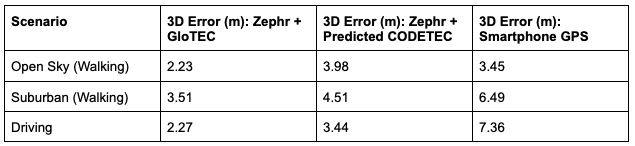
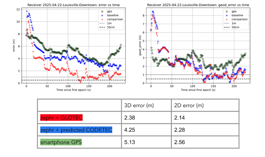
To evaluate the efficacy of GloTEC in improving GNSS accuracy, engineers at Zephr used the virtualized positioning engine to conduct 51 real-world campaigns across various conditions – including urban, suburban, static, walking, and driving – using a Pixel 8 smartphone and an RTK unit for ground truth.
The results were promising, as shown in Figure 1:
Figure 1: GloTEC vs. CODETEC vs. Android Native across multiple scenarios. (All figures provided by author)
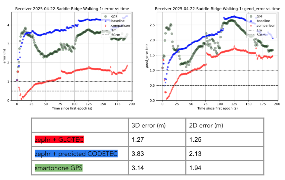
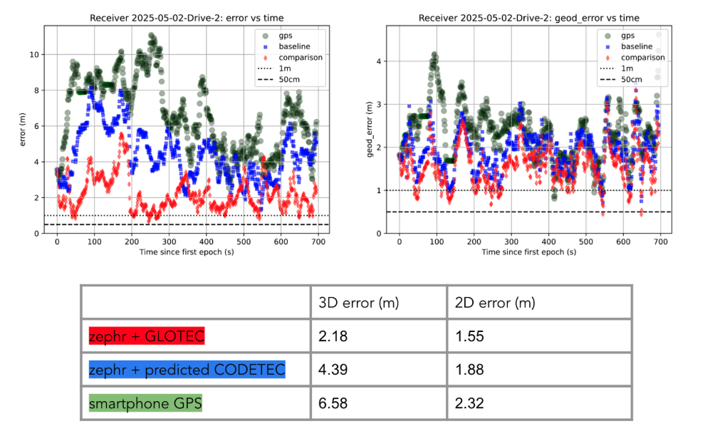
We can break down these results using detailed graphs for each scenario as examples. This will provide a more in-depth look at the positioning for specific traces through the outlined scenarios in Figure 2, Figure 3 and Figure 4:
Figure 2: GloTEC vs. CODETEC vs. Android Native for an open sky walking scenario
Figure 3: GloTEC vs. CODETEC vs. Android Native for a suburban downtown walking scenario.Figure 4: GloTEC vs. CODETEC vs. Android Native for a mixed sky driving test.
Across all categories, the GloTEC-based regional fitting approach significantly outperformed both the default GNSS solution (which uses broadcast data plus a Klobuchar mode) and the competing IGS products. Accuracy improved by up to 69% in driving scenarios and 46% in walking scenarios, compared to standard smartphone GPS.
While the Pixel 8 used in testing supports dual-frequency GNSS, smartphones face several practical limitations that hinder effective use of ionosphere-free dual-frequency combinations. These include limited signal availability (due to antenna constraints, L1/L5 support gaps, and partial constellation coverage), elevated multipath and noise (especially from omnidirectional antennas in dynamic conditions), and unstable clock biases that complicate error modeling. In fact, iono-free combinations can amplify multipath effects, potentially degrading accuracy in some conditions.
Despite these constraints, the results show that meaningful improvements in positioning are possible using a software-based approach with publicly available corrections. GloTEC, when paired with cooperative or cloud-based GNSS engines, offers a substantial step forward without requiring expensive commercial correction services or specialized hardware.
Broader Implications and Next Steps
While these results are promising, several challenges remain before GloTEC-based corrections can be broadly deployed:
Connectivity Requirements: Real-time access to GloTEC requires periodic downloads over cellular or Wi-Fi connections, raising questions about reliability in low-bandwidth or disconnected environments.
Global Calibration: The accuracy of regional fitting depends on local coverage density and VTEC variability. Further tuning may be needed in equatorial or polar regions, where ionospheric behavior is more volatile.
Nevertheless, the availability of GloTEC marks a significant milestone. For the first time, a free, real-time, high-resolution ionospheric correction product is accessible to developers, researchers, and engineers seeking to improve GNSS accuracy at scale. NOAA SWPC has plans to integrate more low-latency space-based and ground-based data into GloTEC in the near future. The new version of the model outputs will be released to the public once the results are validated. As techniques for applying it to mobile and IoT devices mature, the GNSS community may see a broad shift toward more precise, resilient, and cost-effective positioning systems.
GloTEC may have been designed to help forecasters monitor the response of the ionosphere due to space weather events, but its potential to provide an advanced tool for positioning on Earth is just beginning to be understood. In a world where nearly every mobile application depends on location, and where the cost of poor accuracy is rising (from package delivery failures to navigation errors), this kind of public infrastructure is invaluable.
Researchers and industry developers alike should explore how this NOAA capability can be integrated into their positioning systems. If properly supported, GloTEC could become one of the most impactful GNSS innovations of the decade.
In response to the recent wildfires in Southern California, Topcon Positioning Systems is now offering free access to its GNSS correction services network for emergency recovery efforts. The company is offering a 90-day subscription to its Topnet Live service, which delivers precise positioning data crucial for assessing damaged infrastructure, surveying, utility mapping and operating construction equipment.
The technology is being made available at no cost within affected areas to support first responders, public works teams, and other professionals involved in damage assessment, infrastructure repairs, and rebuilding initiatives. The service is compatible with any brand of receiver capable of using RTCM format NTRIP corrections.
“We want to help the efforts that are ongoing and aid in the future reconstruction of the damaged communities from these wildfires,” said Jason Killpack, director of Topcon emerging business development. “The 90-day emergency subscription service is free to anybody that needs them to get their essential job done.”
Individuals or organizations seeking to activate this service can contact participating Topcon distributors in California. Contact information is available on the company’s website for those interested in utilizing the emergency assistance.
GEODNET has released a real-time kinematic (RTK), centimeter-precision, GNSS corrections service designed for OEMs and system integrators of agricultural robotics. GEODNET is compatible with several GNSS receivers from major brands, on-vehicle automated steering, spraying kits, and most UAVs and robots.
The GEODNET corrections service has more than 1,700 total full-constellation reference stations worldwide and supports GPS, Galileo, GLONASS and BDS signals. It also has the RTCM 3.2 data format for maximum rover/receiver compatibility and NTRIP sign-on and access.
Additional local reference stations can be added.
Free GEODNET correction service trials are available now for qualified OEMs and system integrators in most agricultural regions globally. Interested parties can apply for a trial stream here.
While single-base real-time kinematics RTK can, under specific conditions, be the best option for certain applications in surveying and construction, corrections services typically eschew this solution in favor of network RTK, PPP, and PPP-RTK. There are, though, some agricultural networks made up of clusters of reference stations delivering RTK corrections. (Images: courtesy of Gavin Schrock and Courtney Townsend Bigmouse108/iStock / Getty Images/Gettu Images)
The boom in the development of corrections services for applications such as autonomy and robotics has brought a whole new slate of market players, and an expansion of services from established corrections providers. This has benefitted high-precision users as well as the new not-so-high-precision applications.
Whereas very high precision — centimeters — is of paramount importance to sectors such as precision agriculture, construction automation, surveying and mapping, new market sectors are less concerned with precision as they are with reliability, availability and resilience. There are many corrections services that can deliver reliable lane-level precision, decimeter precision, sub-meter or whatever the application requires.
Corrections have been around in various forms for nearly 30 years. Whereas traditional high-precision applications would access corrections services or network infrastructure directly, the user of a mass-market application, such as assisted or autonomous driving, receives corrections second or third hand.
A car manufacturer may install an integrated navigation and positioning system (GNSS is typically only one of many technologies in a complete system) from a vendor that receives corrections from one or more corrections services.
A Recap of the Technology
Uncorrected GNSS is limited to precisions in meters. This may be fine for many purposes, such as coarse navigation and local-based apps. However, for high precision uses, external augmentations (commonly referred to as “corrections”) add more and higher accuracy data to help mitigate multiple sources of error that otherwise limit standalone GNSS results. Various augmented data can be delivered via radio, the internet, or communications satellites. Delivery of augmentations by public or commercial generators of this add-on data is broadly referred to as “positioning services.”
Network RTK, implemented as real-time networks (RTN), covers hundreds of localities, states, and entire countries and is a go-to for many applications in surveying, mapping, construction, monitoring and agriculture. One disadvantage, compared to PPP, is reliance on terrestrial IP communications. (Images: courtesy of Gavin Schrock and Courtney Townsend Bigmouse108/iStock / Getty Images/Gettu Images)
There are two fundamental approaches to generating corrections: Observation Space Representation (OSR) and State Space Representation (SSR). OSR uses observations of one or more base receivers to derive correction values representative of local conditions. Examples of OSR include base-rover real-time kinematics (RTK) and network RTK (NRTK). SSR provides “states” of conditions derived from terrestrial tracking networks, to improve clock and orbit “products,” and may also include data from global, regional, or localized ionospheric and tropospheric models. Examples of SSR include precise point positioning (PPP) solutions.
Players in the corrections services sector include vendors who manufacture GNSS hardware, RTK systems, and NRTK software. One example is real-time networks (RTN), which have grown to cover hundreds of localities, states, regions, and even entire countries. Some of these vendors now operate their own wide region RTN. The same large vendors also have developed global PPP services. The most recent decade though has seen rapid growth in new corrections service providers that focus on one or more key markets and develop approaches specifically to serve them. For instance, many agricultural regions of the world have large clusters of RTK stations operated by a vendor or a cooperative. Some newer vendors, focused on the autonomy market, have developed global PPP services, regional NRTK, or hybrids for decimeter to meter precision. One Achilles heel of PPP is its relatively poor vertical precision compared to RTK and NRTK. This partly explains why adoption has been slow for certain high-precision applications, such as surveying.
Where corrections services have become quite interesting, is in amalgams of these approaches. In recent years, the rapid expansion of corrections services for mass-market applications has given rise to what developers call PPP-RTK. Ostensibly, this is to take advantage of the strengths in each approach, however it may be more about trade-offs between precision and the practicalities of serving wide regions in a cost-effective manner. There are many variations on how this hybridization is achieved; for example, PPP- ambiguity resolution (PPP-AR). PPP-RTK can be somewhat of a nebulous term, much in the same way as the term “AI” gets used. Developers of the specific PPP-RTK approaches for the many corrections services keep certain details close to their chests. Clients are less concerned with how it works as they are with the results.
Examples of Vendors
In compiling the following list, we tried to provide examples of all aspects of the corrections service industry — from GNSS network software development to hosting of national and regional networks to providing global PPP. This segment continues to grow; new players continue to develop solutions and enter the market, some with great fanfare, while others seek to stay under the radar. This list does not include the many hundreds of RTN worldwide — local, regional, or national — though the key providers of the NRTK software these networks use are listed.
One advantage of PPP and PPP-RTK over RTK and NRTK is that they can deliver augmentations by satellites, eliminating reliance on terrestrial communications networks. Satellite delivery has a downside: the number of communications satellites broadcasting the augmentations is limited, which can be problematic in sky-view challenged areas. (Image: courtesy of Gavin Schrock and Courtney Townsend Bigmouse108/iStock / Getty Images/Gettu Images)
Note that other vendors are also not listed, such as some that seek to limit their visibility to specific clients and partners. For example, some offer corrections services as an adjunct to inside hardware/software sales, and others work with developers of certain integrated navigation/autonomy systems. In addition, some of the smaller vendors may be working in conjunction with some of the more established developers, often licensing elements of their software, and in many instances piggybacking on their global tracking networks.
In alphabetical order: Atlas. From Hemisphere GNSS. A global PPP service delivered by L-band satellites. It includes tiered precision for different applications, such as surveying, mapping, and asset management. Atlas Basic, Atlas H30, Atlas H10: bit.ly/3V42qxj. CHCNAV. CPS NRTK software: bit.ly/3FI6zlN. It also hosts various RTN and has a global network partner program: bit.ly/3VQugOr. CNH. Advance Farming Software (AFS) RTK+ network delivering corrections mostly via cellular to primarily precision agriculture users: bit.ly/3YiCZur. DigiFarm. DigiFarm VBN. An example of another network that serves primarily agriculture users, however, it now has a spinoff to serve other high precision markets: bit.ly/3hgnYZs. eSurvey. GNSS NET, a VRS management software: bit.ly/3Py0uMp. Fugro. Global PPP corrections services; tiered precision for various applications, mostly maritime and marine construction. StarFix, SeaStar, MarineStar, OceanStar: bit.ly/3W4LkA8. Geo++. One of the first developers of GNSS network and PPP solutions. Its GNSMART software suite provides NRTK and SSR broadcast capabilities: bit.ly/3FhGE2Z. HERE Technologies. HD GNSS, a PPP-RTK solution for mass-market applications: bit.ly/3Fnle4H. Hi-Target. Hi-RTP, a global PPP- RTK service: bit.ly/3hi2xHv. IGS. International GNSS Service, a federation of agencies and research entities with a global tracking network of more than 400 reference stations. The IGS is a vital component of the global geodetic infrastructure. RTS is its real-time PPP service. It is not fast converging like many of the commercial services, but it is free for many applications. It is not broadcast via satellites, only via the internet: igs.org. Leica Geosystems. Part of Hexagon. Provider of NRTK software (Spider), and host of its own RTN covering various regions around the world (SmartNet), and global PPP (SmartLink): bit.ly/3uEwHb9. NovAtel. Part of Hexagon. Includes various tiers of PPP-RTK: RTK Assist, RTK Assist-Pro*, TerraStar-L, Oceanix, TerraStar-C PRO*, and TerraStar-X* (what NovAtel calls“RTK From the Sky”): bit.ly/3HzuqWh. Point One. RTK correction service called Polaris, available also via partners such as Bad Elf: bit.ly/3uPJGqA. Premium Positioning. RTKcorrections service called RTK Premium: bit.ly/3uT0xZi. Rx Networks. A mix of tiered positioning approaches for location- based applications. Truepoint. io (DGNSS, PPP, PPP-RTK): bit.ly/3We1rvT. SBAS (Public). Satellite-based augmentation systems, national or regional services. Like commercial PPP, SBAS corrections are mostly served via satellites. Public safety and civil aviation are the primary drivers for providing such services. For instance, in North America, the Wide Area Augmentation System (WAAS) was chartered by the Federal Aviation Administration (FAA). There are equivalent systems in Europe (EGNOS), India (GAGAN), Japan (MSAS and QZSS), Russia (SDCM), China (SNAS/BDSAS, which is still in development) and Australia and New Zealand (SouthPAN). Other systems are in development in South America and the Caribbean (SACCSA), Korea (KASS) and in Africa and the Indian Ocean (ASECNA). Sino/Comnav. CDC.NET CORS software, RTN software: bit.ly/3W56hvm. Swift Navigation. Skylark RTK and Skylark DGNSS services: bit.ly/3HyWVn5. Tersus GNSS. Tersus Advanced Positioning (TAP), a PPP service: bit.ly/3hoZkWD. Topcon. TopNet and Topnet Live. RTN Software, regional RTN, and PPP services: bit.ly/3FRRcaw. Trimble. RTN software, VRS Now (regional RTN), and tiered PPP services: CenterPoint RTX, RangePoint RTX, ViewPoint RTX, and FieldPoint RTX: bit.ly/3V3bbax. u-blox. PointPerfect regional PPP and PPP-RTK: bit.ly/3FPVmQo. Veripos. Part of Hexagon. Tiered global PPP services, originally focused on maritime applications: Standard, Ultra, APEX: bit.ly/3BBjfsf. Verizon. Telecom infrastructure-based PPP-RTK service called ThingSpace: bit.ly/3Fw1U55. Vodaphone. Currently developing corrections services in conjunction with Topcon: bit.ly/3Pug4s0.
Whatever the application, there are now many options for corrections services. Non-mass-market applications, for traditional high- precision uses, have been tapping such services for (in some cases) decades. The prize of primacy in the autonomy market has been in the sights of many of these vendors for many years, yet there have been relatively few real-world applications to date. That should be changing soon. Early adoptions such as GM’s Super Cruise, which is powered by the same core PPP technology as RTX, have been quite successful. Which will come out on top? That might be a moot question. With the potential of such markets so great, perhaps there is room for all of them, and more.
An interview with Markus Uster, head of product center positioning at u-blox about recent GNSS receiver innovations.
Uster
What was the most significant technical innovation in your GNSS receivers in the past five years?
The u-blox F9, launched in 2018, is our robust and versatile high-precision positioning technology platform. It was the first receiver to enable multi-band high-precision positioning solutions for mass-market industrial and automotive applications — and remains the benchmark for the industry today.
The platform combines multi-constellation (continuous reception of four satellite constellations) GNSS technology with dead reckoning and high-precision algorithms. It is also compatible with a variety of GNSS correction data services to achieve positioning accuracy down to the centimeter level.
The u-blox F9 platform is leading the next generation of high-precision navigation with its augmented reality, unmanned vehicles and various machine automation applications. It has since been integrated into a selection of modules catering to a wide range of applications.
What has it enabled users to do that they could not do before?
The u-blox F9 is a widely adopted multi-band GNSS platform for automotive and industrial applications. (Photo: u-blox)
In a nutshell, the u-blox F9 brought high-precision positioning to the mass market. The demand for scalable high-precision technology is growing rapidly, as evident in the automotive world with next-generation advanced driver-assistance systems (ADAS) and in robotics with applications such as UAVs and robotic lawnmowers. However, due to the complexity, size, power and cost restrictions of existing high-precision solutions, until now it has been difficult to meet the demands of these markets.
u-blox developed the u-blox F9 platform by building on the success of our NEO-M8P high-precision GNSS module series and drawing on our extensive experience in GNSS positioning technologies, including dead reckoning, multi-band, real-time kinematic (RTK) and GNSS correction services. The platform delivers the next level of scalable GNSS high-precision technology and shows how u-blox is consistently addressing challenges and driving the GNSS technology evolution.
What is a good example of this?
Integration of the u-blox F9 platform into various applications has proven quite successful in a diverse range of use cases. In the industrial realm, u-blox F9 technology enables mass adoption of commercial unmanned vehicle applications. One example is precision agriculture, where high-precision positioning cost-effectively enables vehicle guidance solutions to improve pass-to-pass accuracy resulting in improved crop yield and reduced consumption of pesticides, fertilizer and seeds. The u-blox F9 modules also paved the way for autonomous driving, including lane-level navigation for heads-up displays and vehicular infotainment systems, a prerequisite for highly automated and fully autonomous vehicles.
Onocoy has launched a project to provide a dense network of community-powered GNSS reference stations. Based on Web 3.0 and an innovative incentive program, onocoy’s project strives to ensure outstanding positioning data quality suitable for mass market applications such as drones, micro-mobility, robotic lawnmowers or autonomous vehicles.
In the past, ultra-precise GNSS navigation with real-time kinematics (RTK) was only available to high-end markets because of prohibitive costs. With increasing demand for higher accuracies and advances in receiver technology, along with the availability of new GNSS signals, RTK receiver prices have dropped, yet high correction service costs and insufficient business models for mass markets have limited large-scale application of RTK.
Onocoy’s project aims to provide scalable correction services by leveraging Web 3.0 methods and distributed ledger technology. Such technology will facilitate a decentralized approach to the number of GNSS reference stations, 20 times the density as exist now. Ultra-dense distribution of GNSS reference stations will allow global access to instant centimeter-level positioning.
“Utilizing Web 3.0 methods with distributed ledgers and smart contracts, onocoy is poised to create the world’s densest distribution of GNSS reference stations that will enable RTK positioning anywhere,” said Daniel Ammann, initiator of the onocoy project. “By applying an open governance system, the interests of all stakeholders are taken into account in a transparent manner, ensuring that the project effectively addresses the needs of the stakeholders.”
The project will enable users to have the highest quality in GNSS data thanks to rigorous data validation and an innovative incentive scheme for data miners, where high-quality data is rewarded. Costs will be kept at a minimum with cutting-edge technology implementation and the wide user base. As a result, users will have the freedom to shape their solution to fit their market’s needs.
Aceinna and Point One Navigation launch hardware and software platform for precise positioning in agriculture, construction, mapping, surveying, robotics and trucking
The OpenARC positioning service is now commercially available. OpenARC is a precise-positioning hardware and software platform for system integration of GNSS corrections with high-performance inertial navigation system (INS) and real-time kinematic (RTK) hardware.
OpenARC is offered by Aceinna, a developer of inertial-based guidance and navigation systems, and powered by Point One Navigation.
With an RTK positioning engine and GNSS corrections delivered from a ground-based network of secure base stations, OpenARC will reliably improve position accuracy for autonomous vehicles to centimeter-level accuracy. The platform combines Point One’s Polaris GNSS correction service with Aceinna’s OpenRTK330 hardware and software solution for developers of autonomous systems in trucking, precision agriculture, construction, mapping, surveying and robotics.
OpenARC provides high-precision positioning and localization applications, enabling centimeter-level accuracy for challenging tasks such as lane keeping, precision agricultural guidance, and UAV landing maneuvers.
OpenARC is integrated into the OpenRTK330LI navigation module to provide a secure, vertically integrated and easy-to-use positioning platform. OpenARC is very scalable, supporting single-unit installations and high-volume deployments.
Point One’s proprietary Polaris GNSS cloud correction service delivers superior station density in areas where operators need it the most, including urban centers and suburban surrounding areas, enabling cold convergence times of under 10 seconds.
Polaris provides continuous position monitoring and tracks all modern satellite constellations. Its base-station technology includes advanced anti-jam, interference mitigation, security and integrity monitoring. Its architecture allows for GNSS corrections in RTK or state space representation (SSR) configuration. Its open-source interfaces are compatible with multiple receivers and chipsets, and the service is compatible with any NTRIP/RTCM3 compliant receiver.
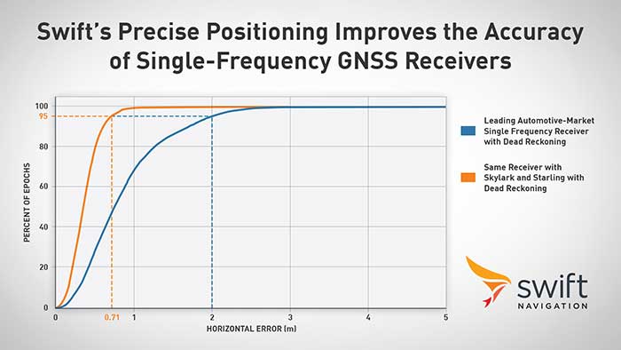
Swift Navigation announced its precise positioning platform can improve the performance of existing single-frequency GNSS positioning, found on most production vehicles today, from the standard average of 3 meters to lane-level accuracy without changing existing hardware and antenna.
According to Swift, these findings are demonstrated during the regular test drives the Swift team conducts to confirm the efficacy of its solutions and software updates. The graph depicts the improved positioning accuracy and availability when a single-frequency receiver is used with corrections from the Skylark precise positioning service and the Starling positioning engine, Swift said. A performance improvement from 2 meters to 0.7 meters for 95% of this mixed-environment drive was achieved on a production vehicle with a low-cost automotive receiver and antenna.
Graph: Swift Navigation
Skylark, Swift’s wide area, cloud-based GNSS corrections service delivers real-time, high-precision positioning, is hardware-independent and is most accurate and seamless when integrated with Starling as a complete solution. Starling is a high-precision positioning engine that works with a variety of automotive-grade GNSS chipsets and inertial sensors, making it ideal for autonomous, ADAS (advanced driver assistance systems), V2X (vehicle-to-everything) and navigation applications, Swift added. Starling is platform-independent and also enhances the measurements for commercially available GNSS receivers.
“Swift is excited to share these findings with the public,” said Joel Gibson, executive vice president of automotive at Swift. “The ability to provide higher accuracy to programs without requiring hardware changes can be a game changer for cost-sensitive programs and brings immediate visible benefit to navigation systems, V2X and many other applications.”
New players are offering GNSS correction services — pushing prices down and offering new business models. What opportunities does this open up?
Jules McNeff
“This trend is encouraging, as new entrants bring energy and new ideas, keeping the PNT technology sector fresh. GNSS corrections enhance the value of dynamic mapping coupled with grid-coordinate systems such as the U.S. National Grid in producing user-friendly geolocation values for delivery of people and things and especially enabling efficient, precise, land mobility activities such as spatial awareness for autonomous vehicle movement and command and control of emergency response operations.” — Jules McNeff Overlook Systems Technologies
Greg Turetzky
“In a 5G world where most devices regardless of size are connected, it make sense that those devices that are mobile are going to need to be located. Correction services are key to providing enhanced accuracy, and new business models are needed to address these new markets that are fundamentally different than traditional high-accuracy markets.” — Greg Turetzky Consultant
Jean-Marie Sleewaegen
“Traditional correction services rely on bidirectional communication between a user and a local correction provider. They offer centimeter accuracy over small regions. Instead, new services broadcast corrections applicable to larger areas and with flexible accuracy levels, from centimeters to decimeters. They bring benefits not only in pricing, but also in terms of accessibility, scalability and ease of use. They make accuracy transparent to the user, opening up the opportunity of high accuracy to mass-market and industrial applications.” — Jean-Marie Sleewaegen Septentrio
Australia-based Position Partners has launched MiRTK, an open architecture corrections service for GNSS equipment.
Internet-enabled, MiRTK offers an alternative to UHF radio correction services for high-accuracy GNSS. Unlike UHF radios, MiRTK is not limited by range from the GNSS base station and does not require line of sight with the survey rover or machine.
MiRTK uses a small modem that slides onto the accessory slot of the tripod and connects to the base station via a single cable.
A subscription service is available in locations with the Telstra network, mainly continental Australia.
MiRTK is designed for accurate GNSS positioning in the construction, mining and geospatial industries. It is compatible with all brands and models of GNSS from manufacturers including Topcon, Trimble, Leica Geosystems, Sokkia, Hemisphere and more.
“Until now, users that rely on high-precision GNSS for applications such as surveying and machine control had no option but to use UHF radios or a network RTK solution,” said Cameron Waters, geospatial business manager at Position Partners.
“Anyone that’s had to rely on UHF radio frequencies will have experienced problems, including interference, range limitations, costly licensing and severe penalties for breaching licensing laws. MiRTK offers an alternative that is refreshingly simple: no repeaters, no line of sight issues and no complex licensing,” he added.
The Galaxy lithium mine in Ravensthorpe, Western Australia. (Photo: jasonbennee/iStock / Getty Images Plus/Getty Images)
Another benefit, according to Waters, is the ability to utilise a single correction protocol across all GNSS equipment on site. This dramatically reduces complexity and potential connectivity issues. “MiRTK uses NTRIP and a user selectable format such as RTCM3 or CMR, that can be used universally regardless of the brand or model of equipment,” he said. “Users enjoy full speed, full constellation connectivity without the complex radio settings, baud rates, bandwidth or scrambling problems that you get when trying to utilize different GNSS systems with UHF radios.”
To set up the unit, users simply connect the modem to the base station, power the modem on and MiRTK will work for up to 20 hours continuously without charge. Each unit can connect with up to 10 devices such as survey rovers or machine systems as standard, with unlimited potential to scale up connections as required.
“The future of UHF is limited with lower bandwidth, higher density areas, increased governance, rising costs and little flexibility,” Waters said. “MiRTK gives customers a new approach to receive reliable correction data in a simple and hassle-free way, whilst utilizing their existing GNSS hardware.”