Tag: GNSS interferemce

  • Todd Humphreys: Russian satellites a cause of GNSS jamming across Europe

    Todd Humphreys: Russian satellites a cause of GNSS jamming across Europe

    Russian satellites have caused GPS outages of as long as 10 seconds across Europe, according to a new research paper, authored in part by GNSS expert Todd Humphreys.

    Humphreys is head of the Radionavigation Laboratory at the University of Texas at Austin. Separate research by Richard Bowden at Spanish company GMV supports the findings, according to The New York Times.

    In at least three of 75 instances identified since 2019, the interference originated from as many as three Russian satellites. The other cases implicate the same Russian early-warning network; though data is insufficient to pinpoint the source, the same type of signal was identified.

    Whether Russia knows of the interference — and its motives — is unknown, but the signals disrupt GPS, Galileo and BeiDou, and not Russia’s own GLONASS. The press office for the Russian Embassy in Washington, D.C. told The Times it had no comment.

    The paper, “Chasing Lightning: Detecting, Characterizing, and Identifying a Powerful Space-Based GNSS Interference Source” by Zachary L. Clements, Argyris Kriezis and Todd E. Humphreys, can be accessed here.

    The paper provides a comprehensive analysis of the GNSS interference phenomenon: wide-area transient interference from a space-based source causing up to 10-dB GNSS degradation across Europe since 2019 in the L1 band. The interference’s spatial, temporal and spectral properties are detailed. The researchers designed a framework to detect events using 1-Hz carrier-to-noise ratio observables from a network of 165 reference stations.

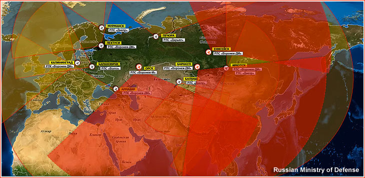
    The three satellites implicated in the interference are part of Russia’s Edinaya Kosmicheskaya Sistema (EKS) constellation, which detects missile launches and nuclear explosions around the world. The first instance of this widespread jamming was recorded in October 2019, a month after the first EKS satellite was launched.

    These cases are among the first known examples of GPS interference originating from space. Two historic cases of satellite interference were caused by technical glitches.

  • Russian sabotage of Baltic Sea states is analyzed in a new white paper

    Russian sabotage of Baltic Sea states is analyzed in a new white paper

    Russian acts targeting critical infrastructure, satellite signal interference paralyzing maritime and air navigation, and cognitive operations aimed at intimidating European societies are examples of Russian hybrid activities targeting the Baltic Sea region states.

    The paper, “White Paper on Russian Acts of Sabotage and Subversion against Members of the Council of the Baltic Sea States,” can be downloaded here. Authors Filip Bryjka, Anna Maria Dyner and Aleksandra Kozioł are with the Polish Institute of International Relations.

    The report explores GNSS signal disruptions in the Baltic Sea and how it affects the safety of maritime and air traffic.

    Scale and Methods of Russian Operations

    Since the beginning of the full-scale invasion of Ukraine, Russia has intensified its hybrid activities against NATO member states, particularly those that have most actively supported Ukrainian resistance. This group includes the members of the Council of the Baltic Sea States. It is against them that the vast majority of acts of diversion and sabotage recorded in Europe since February 2022 have been directed.

    Russia deploys a full spectrum of tools against the region:

    • Acts of diversion and sabotage targeting critical infrastructure.
    • Border incidents: Violations of airspace and maritime borders.
    • GNSS signal disruptions (satellite radio transmissions), creating operational problems for maritime and air navigation.
    • Cognitive influence, aimed at causing measurable damage, testing state responses, and inducing a sense of growing threat among societies.

    Recommendations: How to Counter Hybrid Threats?

    The offensive nature of Russian actions demonstrates an intent to destabilize NATO and EU countries. Effective defense requires developing shared mechanisms:

    • Close cooperation among agencies: Ensuring a high level of situational awareness through the coordination of activities (at both national and international levels) among military and civilian intelligence, counterintelligence, border guard services, and the police.
    • A dedicated information exchange system: Leveraging the geographical proximity and potential of the CBSS states to quickly share threat data.
    • Unambiguous attribution of persuasions: Publicly naming Russia as the author of the attacks. A lack of clear attribution hinders coordinated preventive and retaliatory measures.
    • A catalog of best practices: Developing common rules for monitoring, reporting, and responding to known and repetitive Russian operational patterns.

    The authors conclude that only a full spectrum of coherent measures taken by all states in the region, alongside NATO and EU structures, can effectively influence Russia and reduce the risk of future incidents.

  • Kolkata is latest Indian city to be affected by GNSS interference

    Kolkata is latest Indian city to be affected by GNSS interference

    India has issued a Notice to Air Missions (NOTAM) warning of possible GPS interference or signal loss along air traffic routes near Kolkata, reports Business Today.

    The NOTAM, valid Nov. 13-17, alerts airlines and pilots to remain vigilant to GNSS disruptions. It follows previous communications sharing issues with GNSS interference in New Delhi and Mumbai. Pilots and air traffic controllers also were asked to report any interference incidents within 10 minutes to the Directorate General of Civil Aviation (DGCA).

  • India increases efforts to collect GNSS spoofing data

    India increases efforts to collect GNSS spoofing data

    India’s aviation regulator, the Directorate General of Civil Aviation (DGCA), is collecting data on GPS interference and spoofing to have a better understanding of the situation, reports several news outlets in the country. The urge to collect data comes after the Delhi airport experienced issues in the past few days.

    Following a circular issued by the Directorate General of Civil Aviation in 2023, instances of GPS interference/spoofing have been reported since November 2023.

    Recently, several airlines have faced GPS spoofing at the New Delhi airport, with at least eight such instances on Nov. 5, said an unnamed DGCA official. The interference instances were noticed in domestic and international flights.

    Generally, interference issues are reported in border areas, rather than at Indira Gandhi International Airport, the country’s busiest. Daily flight movements have increased to more than 1,500 following an airport terminal upgrade completed in October.

    As many as 465 GPS interference and spoofing incidents were reported in the border region, mostly in the Amritsar and Jammu areas, between November 2023 and February 2025.

  • SeRo Systems offers integrated air and ground GNSS interference monitoring

    SeRo Systems offers integrated air and ground GNSS interference monitoring

    Combines airborne and ground-based GNSS interference monitoring in a single integrated system for unified situational awareness.

    SeRo Systems, a leader in air traffic surveillance security and monitoring solutions, has introduced a new ground-monitoring capability to its SecureTrack solution, enabling unified air- and ground-based detection of GNSS interference, including jamming and spoofing. This comprehensive feature delivers real-time detection, analysis and visualization of jamming and spoofing activity across all GNSS frequency bands and constellations in a single integrated solution.

    Compliant with the latest EASA and ICAO monitoring recommendations, it also offers data archival and analytics capabilities for detailed reporting. The company started rolling out this feature to users in Eastern Europe and the Baltics in mid-October.

    Designed for use by Air Navigation Service Providers (ANSPs), airport operators, spectrum regulators and other government agencies, this capability uses a dedicated and controlled deployment of SeRo’s GRX receivers to display continuous, high-resolution power spectral density data (spectrogram) covering an RF band over 318 MHz wide.

    Through advanced spectrum visualization and data aggregation, users gain valuable insights into the spectral fingerprint, enabling them to identify when interference occurs, which frequencies are affected, and distinguish between unintentional interference and targeted attacks.

    “With this release, our customers get the highest level of protection a single system can provide,” said Matthias Schäfer, CEO of SeRo Systems. “Until now, authorities had to rely on fragmented data from different systems to monitor air and ground operations. SecureTrack now provides a unified view of live and historical GNSS interference activity in an easy-to-use interface for faster incident detection and improved system integrity. This offers an intuitive and efficient way to visualize complex RF spectrum and signal data collected by our sensors in areas that are critical to GNSS operations. It’s the perfect solution for ANSPs, airport operators, and spectrum regulators who need comprehensive situational awareness in a single integrated tool.”

    With the system’s new continuous ground monitoring functions, users can view live spectrum activity or perform historical analysis over customizable time ranges. Data is displayed on intuitive waterfall and line charts that show signal amplitude over time, with color-coded intensity scales that make jamming and spoofing events immediately visible.

    Its upcoming automatic alerting feature will provide real-time warnings of potential jamming or spoofing incidents by detecting unexpected positioning, navigation and timing (PNT) signals as well as anomalous spectrum activity.

    The integrated Sky Plot offers additional insight into satellite positioning and antenna performance, helping users optimize installation geometry and, in the event of spoofing, understand which satellites and constellations are affected.