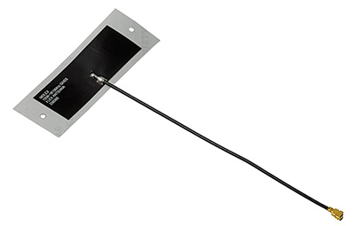
Swift Navigation and SimCom are partnering to deliver centimeter-level GNSS accuracy to high-volume robotics applications worldwide. The collaboration integrates Swift’s Skylark precise positioning service with SIMCom’s high-performance SIM66MD and SIM66D GNSS modules.
This combination allows manufacturers and developers using these modules to activate centimeter-accurate satellite positioning, dramatically improving the performance, safety and reliability of robotic lawnmowers, delivery robots, agricultural vehicles, and other autonomous systems. SIMCom’s GNSS modules have compact designs, low power consumption, and wide array of interfaces, making them suitable for seamless integration into diverse IoT and autonomous devices.
Swift’s Skylark Nx RTK, the highest precision variant of Skylark, leverages a proprietary atmospheric model to deliver continuous 1-2 cm accuracy across vast geographic areas, including all of Western Europe. The carrier-grade network eliminates the need for developers to manage base stations or switch between multiple correction providers, simplifying deployment of high-precision outdoor robots at scale.
Key benefits for autonomous navigation:
Autonomous Operation. Centimeter-level accuracy is essential for robots to execute complex tasks, such as following precise mowing patterns, planting seeds with exact spacing, or navigating narrow construction sites.
Safety and Geofencing. Precise localization enables reliable enforcement of virtual boundaries (geofencing), preventing robots from entering restricted zones or colliding with obstacles, which is critical for safety in public or shared spaces.
Improved Efficiency. Reliable 1-2 cm precision reduces path errors, minimizes overlap in coverage (e.g., in farming or lawn care), and ensures the robot consistently reaches its exact target destination, maximizing battery life and operational uptime.
Customers purchasing SIMCom’s SIM66MD and SIM66D modules now receive a six-month free trial of Skylark Nx RTK.
On Dec. 20, u-blox banned the use of its GNSS modules in military UAVs in the war between Russia and Ukraine. The company had become aware that its GNSS modules were being used in certain Russian reconnaissance UAVs and stated that this use was against company policy.
U-blox obtained media reports that Russia had stocked up on components in anticipation of war, then integrated products from the company in UAVs it manufactured after attacking Ukraine.
After Russia began its invasion of Ukraine, the company halted all sales to Russia, Russian territories, and Russian-occupied areas, as it intends its GNSS modules and other products to be used only commercially. U-blox company policy bans the use of its products in weapons, including systems for target identification.
U-blox is investigating the infringement of its policy and plans to take legal action if it has been violated. The company also condemns the invasion of Ukraine by Russian forces.
A roundup of recent products in the GNSS and inertial positioning industry from the October 2022 issue of GPS World magazine.
OEM
Software
Aids GNSS/INS installation
Photo: Septentrio
The RxLeverArm software tool aids integration of GNSS receivers that include inertial navigation systems (GNSS/INS). RxLeverArm is part of Septentrio’s RxTools software package included with every Septentrio GNSS/INS receiver. The new tool visualizes, validates and automatically calibrates the exact distance between the INS sensor and the antenna, removing the need for accurate distance measurements with complex instruments. For lever-arm compensation, users only need to measure the rough distance between the INS sensor and the main GNSS antenna reference points on the vehicle. Data is then logged under open-sky conditions, which allows the RxLeverArm tool to optimize the initial rough distance measurement and prevent common errors such as sign inversion.
Enables proof of concept for IoT products and applications
Photo: u-blox
The u-blox XPLR-IOT-1 IoT explorer kit is an all-in-one package to test, evaluate and validate applications for the internet of things (IoT). The board hosts an ultra-low-power MAX-M10S positioning module capable of concurrently tracking four GNSS constellations, delivering highly reliable location data. Integrating relevant u-blox technologies and services into a capable prototyping platform with a vast selection of sensors and interfaces as well as cloud connectivity, XPLR-IOT-1 makes it easier to explore the potential of IoT applications.
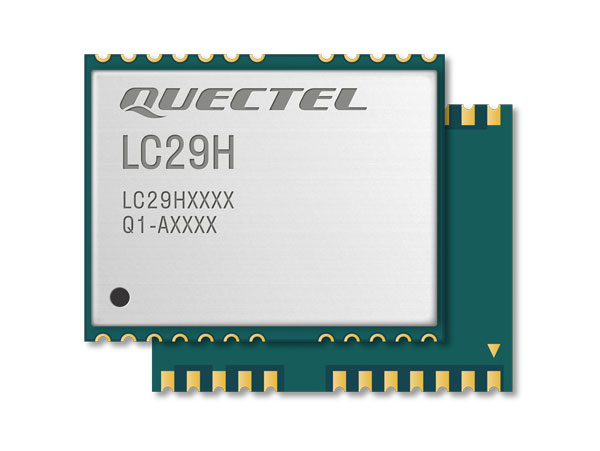
The LC29H is a dual-band multi-constellation GNSS module built using the Airoha AG3335 platform. It is available in multiple variants and optionally integrates real-time kinematic (RTK) and dead reckoning. The LC29H series offers high performance with power efficiency to meet the market needs of high-precision positioning at the centimeter and decimeter levels. The LC29H concurrently receives and processes signals from GPS, GLONASS, BeiDou, Galileo and QZSS. The modules are suited to an expanding market for autonomous lawn mowers, drones, precision agriculture, micro-mobility scooters and delivery robots.
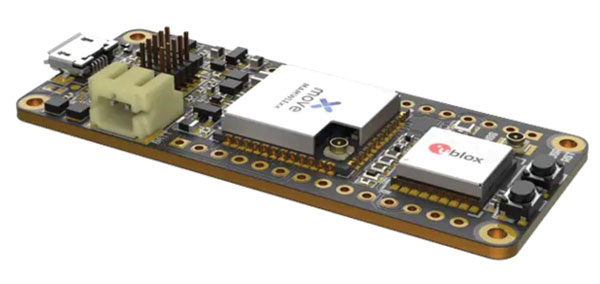
The Cicerone LoRa/GNSS board is a high-performance, low-power, Arduino MKR-compatible development board based on the u-blox MAX-M10S GNSS module and the MAMWLE LoRa module. It delivers high-performance GNSS, long-range wireless connection, and high-performance processing in a low-power solution for optimal battery life. The board allows users to build tracking applications worldwide with meter-level accuracy and to communicate long-range, low-power data via LoRaWAN. The integrated Li-Po charging circuit enables the Cicerone board to manage battery charging through the USB port. It has a compact 63 mm x 25 mm form factor and is compatible with all Arduino MKR shield boards. These boards all share a common pinout to enable developers to easily add expansions with minimal software changes.
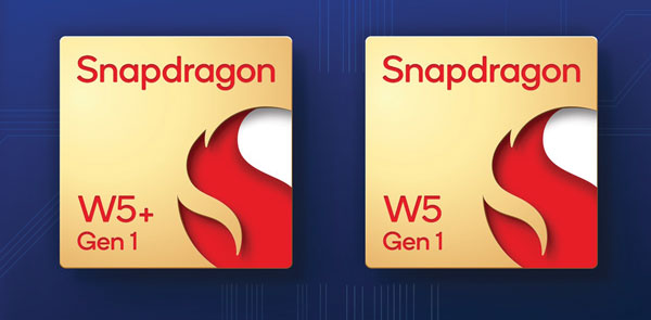
The Snapdragon W5 Gen 1 and W5+ Gen 1 platforms are designed to advance ultra-low power and breakthrough performance for next-generation connected wearables with a focus on extended battery life and premium user experiences. They incorporate innovations including low power islands for GNSS, Wi-Fi and audio; ultra-low power Bluetooth 5.3 architecture; and low power states such as Deep Sleep and Hibernate. New enhancements to the flagship Snapdragon W5+ platform offer 50% lower power, 2x higher performance, 2x richer features, and 30% smaller size, compared to the previous generation. The purpose-built platform is comprised of a 4 nm-based system-on-chip and 22 nm-based highly integrated always-on co-processor. By using these platforms, manufacturers can scale, differentiate and develop products faster in the continuously growing and segmenting wearables industry, Qualcomm said. Qualcomm also announced two reference designs from Compal and Pegatron, which showcase the capabilities of the platform and the company’s collaboration with ecosystem partners, helping customers develop products faster.
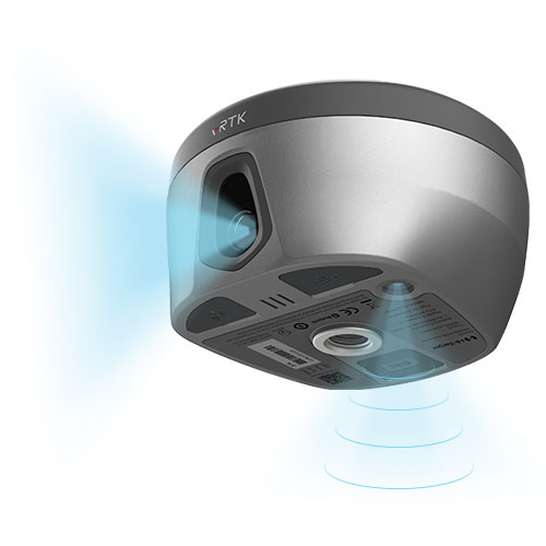
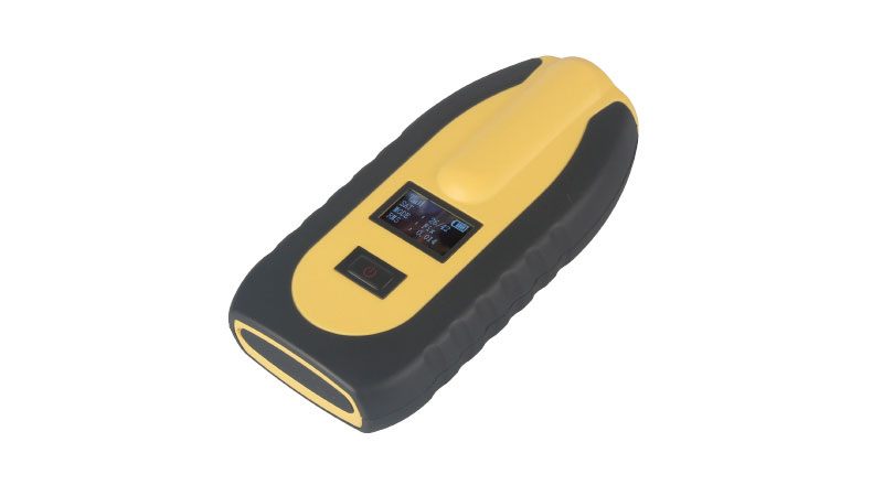
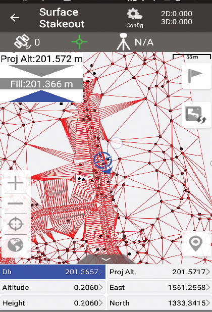
The pocket-sized vRTK GNSS real-time-kinematic (RTK) receiver is equipped with dual cameras to enable non-contact image surveying. It also has a nine-axis IMU module with auto installation for tilt surveying. Visual positioning technology combines imagery with high-precision positioning equipment, allowing users to obtain the location of the target from a distance. The Live View Stakeout function improves stakeout speed, while non-contact measurement greatly improves the usable range of GNSS. The vRTK receives 1,408 channels (GPS, GLONASS, BeiDou, Galileo, QZSS, IRNSS and SBAS). A new generation of GNSS engine supports the new frequency points B1C, B2a and B2b RTK decoding of BeiDou-3 satellites.
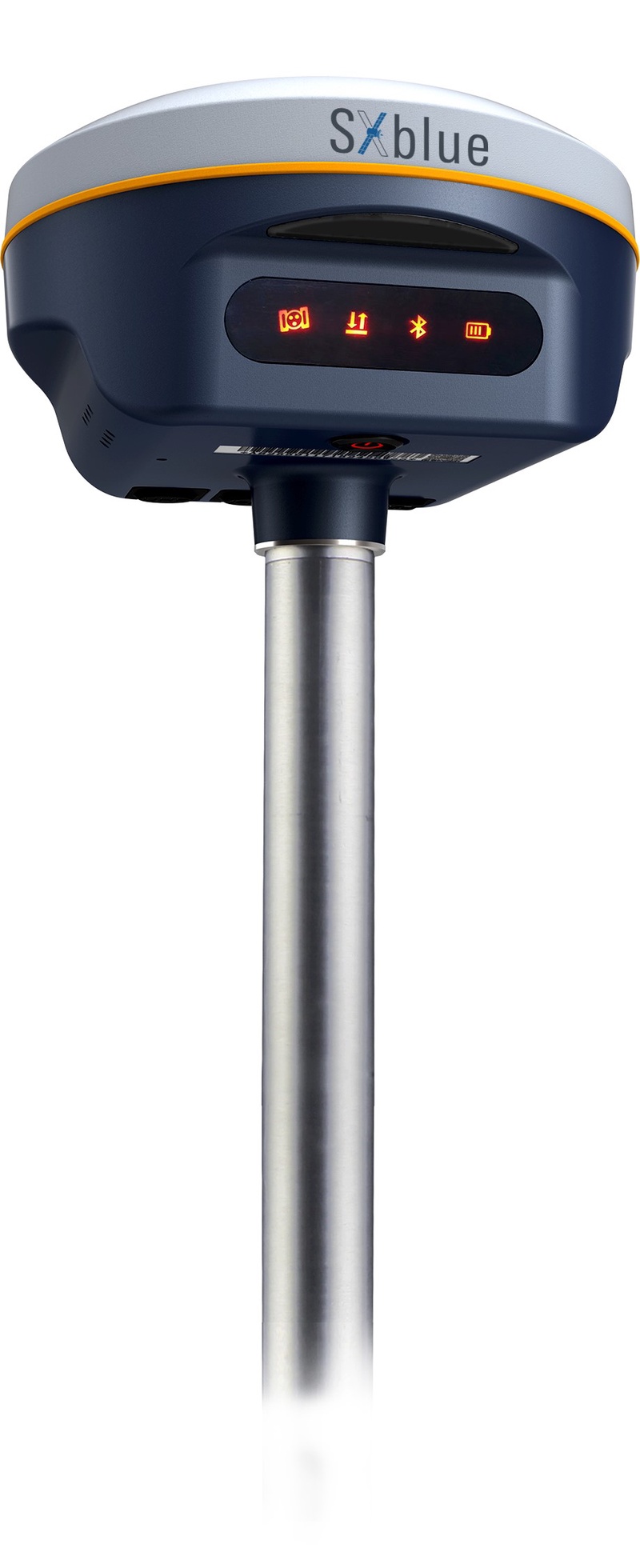
The SXblue SMART features an engine capable of tracking all-in-view GNSS signals, with interference mitigation and optimization for handling a wide frequency band. Weighing 850 g including battery, the SXblue SMART is compact and rugged. Its radio link is based on the Farlink protocol that allows a range of up to 8 km while reserving a wide bandwidth for transmission of real-time kinematic (RTK) data. In addition to a tilt sensor for measurements in hard-to-reach places, the SXblue SMART features a high-performance attitude measurement module that can detect and measure movement of the device. Also integrated are an inertial measurement unit and a thermometer for monitoring and controlling its internal temperature.
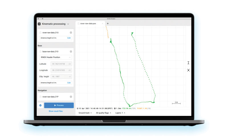
Emlid Studio is a new post-processed kinematic (PPK) application designed specifically for post-processing GNSS data. It allows users to convert raw GNSS logs into RINEX, post-process static and kinematic data, geotag images from drones (including DJI brand), and extract points from survey projects completed with Emlid’s ReachView 3 app. With Emlid Studio, users can post-process data recorded with Emlid Reach receivers and other GNSS receivers or NTRIP services. Post-processing requires RINEX observation and navigation files. Raw data in UBX and RTCM3 format also can be used through conversion.
The P1 GNSS receiver has a high-precision module that tracks GPS, GLONASS, BDS, Galileo, QZSS and SBAS to deliver centimeter-level real-time kinematic (RTK) accuracy even in harsh environments. It is also equipped with an anti-jamming and anti-spoofing algorithm. The P1 GNSS receiver has integrated the GNSS module and GNSS antenna while keeping the device as small as a smartphone, which makes it portable enough to be worn around the neck or placed in a pocket. With 4G/Bluetooth communication, the P1 supports real-time positioning data transmission, providing users with a stable correction data steam and positioning data uploads. The P1 also can be mounted on a pole.
Nuwa surveying smartphone app version 2.3.3.2 has vector map import and digital surface stakeout. The Nuwa app runs on Android and is reliable and easy to operate. It has rich and powerful functions that can help surveyors complete measurements more efficiently and accurately. The app is designed to work with the David and Oscar GNSS receivers from Tersus GNSS, plus other receivers that support NMEA-0183. Features include the ability to configure base, rover and static surveys; graphical interface with background map (online/import); CAD stakeout, road stakeout and earthwork; data management (import/export multiple formats); and Bluetooth and USB connection support.
Version 3.2 of the survey application 1Edit allows the use of Web Maps (WMS) to be used as background layers, making it easier for surveyors to identify assets and changes in context. It provides easier configuration of background maps and supports hybrid working practices for surveyors. Where offline background maps are required, 1Edit supports multiple raster files and handles large image files, providing visual context for geospatial data when there is no data signal. Enhanced support for complex geometries increases efficiency as features with multiple parts share common attributes and IDs.
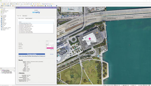
The Smarty U.S. Geocoding QGIS Plugin provides an easy way for users of the software platform to validate, standardize, and convert addresses to their latitude and longitude coordinates (geocodes). The plugin allows manual address entry as well as batch geocoding via CSV. It features a 95% match rate with the actual rooftop and parcel, as well as providing sub-address geocoding that can match secondary addresses such as apartment units and office-suite rooftops in building. The free plugin also includes supplemental metadata useful for many geographic information system (GIS) purposes.
Datasets for the United States, UK, Canada, Australia and Europe
Photo: Maptitude
Maptitude 2022 is a major release of the geographic information system (GIS) and mapping software. It includes up-to-date, accurate data encompassing expenditure, geodemographic segments, gross domestic product, medical and banking locations, branded business locations, traffic counts, building footprints, address points and financial assets, as well as the tools to leverage this information to improve the location intelligence of organizations in markets such as healthcare, franchising, communications, logistics, retail, real estate and banking.
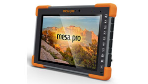
The Mesa Pro rugged tablet features 11th-generation Intel Core processors, a Windows 11 operating system, device customization options, a large sunlight-readable display and the “Juniper Rugged” company design. Standard Mesa Pro units come with an 11th Gen Intel Core i5 processor and 16 GB of LPDDR4x RAM. Core i7 and Celeron versions are also available. Each Mesa Pro configuration offers powerful performance and allows users to select the computing performance that fits their needs and budgets.
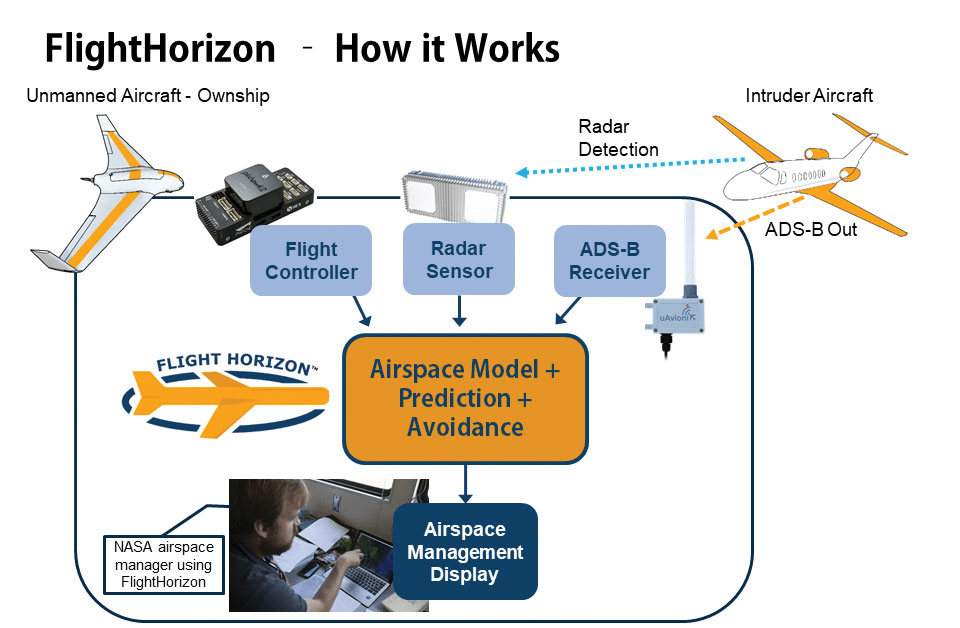
Data fusion across multiple data sources, including ADS-B
Photo: Vigilant Aerospace
FlightHorizon COMMANDER is a situational awareness and safety system for UAV airspace management. The system provides airspace managers with either a 2D or 3D view of all aircraft in the selected airspace using a combination of sensors and data sources to create an airspace safety picture for pilots, airspace managers and command centers. The system is based on an exclusively licensed NASA patent and prototype that has been used in extensive flight testing. FlightHorizon COMMANDER functions as a visualization tool for airspace management, an active situational awareness tool, and a detect-and-avoid system that enables unmanned aircraft to avoid other aircraft and keeps drone pilots and airspace managers aware of the location and air traffic around their UAS and in their airspace.
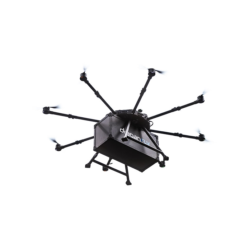
The Draganfly Heavy Lift Drone is a versatile, multi-rotor unmanned aerial vehicle designed to enhance deliveries and flight times. Compatible with a variety of interchangeable payloads, the heavy-duty drone can carry more and fly longer than the typical professional drone. It has a payload/cargo-lift capacity of 30 kg (67 lbs) and up to 55 minutes of flight time. The industrial UAV handles heavy winds and high elevations with ease. Its lifting capacity permits flexibility in carrying large high-end sensors such as hyperspectral and bathymetric lidar to conduct large-area surveys.
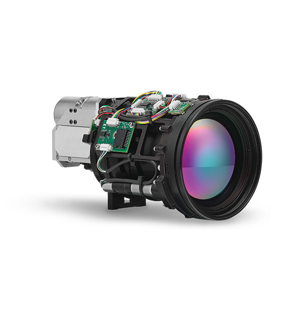
Allows rapid MWIR integration for commercial, industrial and defense applications
Photo: Teledyne FLIR
Part of the Neutrino IS series, the Neutrino LC CZ 15-300 is a new mid-wavelength infrared (MWIR) camera module with integrated continuous zoom lenses. Designed for integrated solutions requiring crisp, long-range MWIR imaging, the camera offers size, weight, power and cost (SWaP+C) benefits to original equipment manufacturers (OEMs) and system integrators for airborne, unmanned, C-UAS, security and targeting applications. The LC CZ 15-300 offers high performance, 640 x 512 high-definition MWIR imagery and 15 mm to 300 mm zoom capability for ruggedized products requiring long life, low power consumption and quiet, low-vibration operation. The camera module and lens are designed for each other, providing optimal performance.
A miniature drone with flapping wings was demonstrated at the Teknofest Black Sea aviation and defense industry event, which took place Aug. 30 to Sept. 4 at the Samsun Çarşamba Airport. With its low detectability, the nano drone is being developed to perform reconnaissance and surveillance missions. It is still in research and development.
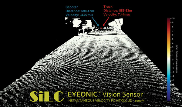
The Eyeonic Vision Sensor can perceive, identify and avoid objects at a range of more than 1 kilometer. The sensor is a frequency modulated continuous wave (FMCW) lidar transceiver that uses a silicon photonic chip. Long-range visibility is a requirement for autonomous vehicles, which require sufficient awareness to evade obstacles at highway speeds. This capability requires vision sensors to provide millimeter-level accuracy and depth at instantaneous velocity. The highly detailed and ultra-long-range information from the Eyeonic Vision Sensor enables robots to classify and predict their environments. The sensor is designed to be integrated into autonomous vehicles, security solutions and industrial robots.
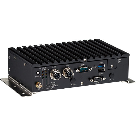
The nROK 1030 is a compact, rugged entry-level vehicle computer with an advanced GNSS receiver. The u-blox NEO-M9N module supports GPS, GLONASS, Galileo, BeiDou and QZSS signals. An Intel Atom x6211E dual-core processor 1.3 GHz/3 GHz (burst) is designed for harsh in-train environments. Its fanless, compact design is suitable for vehicles with limited space. The nROK 1030 has onboard CAN 2.0B for vehicle diagnostics and driver behavior management. WLAN Wi-Fi 6/6E/Wi-Fi 5 and WWAN 5G NR/LTE wireless data connectivity is optional. The nROK 1030 is flexible to meet the demands of various rolling-stock applications, such as wireless gateway, infotainment and digital radio data/voice transmission systems.
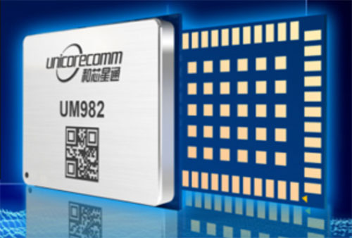
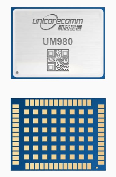
Rx Networks is offering for both the North and South American markets the next-generation high-precision GNSS modules from Unicore Communications, based in China.
Based on the new NebulasIV systems-on-chip (SOC), the UM960, UM980 and UM982 modules offer all-constellation, multi-frequency, high-precision real-time kinematic (RTK) positioning and heading capabilities.
Rx Networks is exhibiting at ION-GNSS+ taking place this week in Denver, at Booth 108, and will exhibit at Intergeo in Essen, Germany, Oct. 18-20, at Booth F2.033.
Available in a small footprint with low-power consumption, the Unicore modules are suited for use in reference stations, surveying and mapping, precision agriculture, heading applications, machine control, drones and robotics, vehicle navigation, precision timing, and more.
Photo: Unicore
Rx Networks is a key supplier of high-accuracy services and assistance data to a growing list of GNSS hardware manufacturers. As high-precision GNSS becomes ubiquitous, those seeking precise positioning solutions can now have Unicore GNSS hardware enlightened with Rx Networks data services.
“We are pleased to be bringing this new leading GNSS Technology into the Americas,” said Cameron Baird, head of Business Development, GNSS Hardware. “With further product miniaturization coupled with added performance, features and functionality, Unicore GNSS technology is well suited for all precision GNSS applications.”
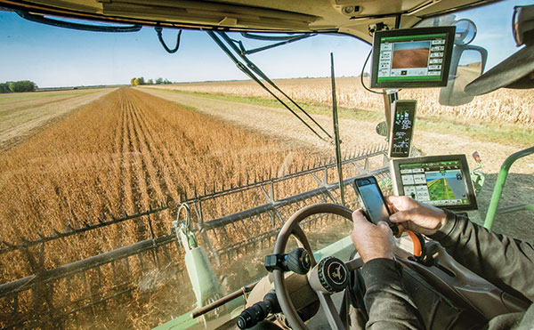
Fuel and fertilizer prices are at all-time highs, as farmers the world over are scrambling to find ways to stay financially afloat. Large commercial farms have long had a leg up over smaller holdings. They already have access to artificial intelligence (AI) and cutting-edge hardware to plan their operations and automate tasks. They run broad sensor networks to monitor soil quality, operate vision-enabled drones to monitor crop health, and let autonomous tractors steer across their fields to vastly improve their productivity.
These advanced systems have been prohibitively expensive, to the point that their costs are hard to justify for smaller holdings, less than two hectares in size, which make up the vast majority of the world’s more than 570 million farms. Many of these farmers simply don’t have access to sufficient capital to invest in new equipment, and continue to rely on older machines and human labor. For them, the vast promise of the digital revolution to increase the efficiency of agricultural operations — typically lumped together as smart farming or precision agriculture — has long remained just out of reach.
But change is in the air. Over the past few years, the popularization of the internet of things (IoT) and its underlying technologies has led to the development of a new and more affordable generation of precision farming solutions. These solutions are giving smallholdings tools to increase the quantity and the quality of their production. Combining satellite-based positioning, wireless connectivity and visual sensing with advanced algorithms including machine learning (ML) and artificial intelligence, these solutions promise to help farmers produce more for less, putting them on more equal footing with their larger commercial competitors.
In this article, we take stock of key trends driving the democratization of precision agriculture. We zoom in on some of the concrete applications transforming the operations of smaller farms the world over. We start by exploring the core enabling technologies, the applications they enable, and where they are headed.
Technological evolution on all fronts
Sensor-fusion platforms
At their heart, precision agriculture solutions are sensor fusion platforms, taking in data points from a variety of sensors, using algorithms to make sense of them, and extracting insights on which their users — machine or human — can act. As they mature, these sensor fusion platforms are becoming increasingly complex, crunching more and more types of sensor data with algorithms of growing sophistication to gain ever deeper and higher value insights.
These insights are often generated using AI and ML models that run at the edge of the network near the sensors — on the tractors, sprayers, or other devices themselves — rather than in the cloud.
Equipment manufacturers looking to integrate AI/ML at the edge are weighing their options in terms of adding application processors and hardware accelerators capable of running advanced ML models needed to fuse camera and sensor inputs to make real-time decisions. To simplify the adoption of AI/ML at the edge, many vendors are starting to integrate AI accelerators into their modules and systems-on-chip (SoCs), lowering the barrier to entry.
Original equipment manufacturers (OEMs), for their part, are choosing to integrate these SoCs even if their software capabilities are still behind. For them, building solutions with future-proof hardware is a potentially lucrative strategy for generating recurring revenues through firmware updates that provide advanced functions down the road.
Despite the abundance of evaluation kits from major vendors, scaling from prototypes to production with these solutions can be expensive. While integrated sensor fusion platforms with, for example, pre-loaded dynamic vehicle models for auto-steering or computer vision models for plant health can accelerate development for OEMs and reduce the need for software investment, they can be too generic and may not solve use-case-specific needs. More focused AI/ML may require more investment in data collection and training models, which, due to their proprietary nature could come at a higher price.
Camera systems are already widely relied on by autonomous tractors, visually monitoring the surrounding environment and feeding their data into computer-vision solutions where it is parsed. Context-rich, vision-based data can help optimize the distribution of agricultural inputs such as water, seeds, fertilizers and pesticides using real-time variable spray-rate control based on plant size and other metrics to significantly improve efficiencies and reduce overall costs.
Camera systems come with a set of challenges that need to be carefully managed. Lenses can become contaminated with water, debris, dust, and snow. Even though these issues impact all vision-based applications, including mass-market applications such as automated and autonomous driving, there are still no reliable methods of keeping them clean, aside from water-spraying nozzles (that can cause buildup on the lenses) and old-fashioned manual maintenance.
Additionally, the steep price of high-resolution cameras can drive up the cost of end solutions, as can data storage and communication when the visual data is processed in the cloud.
Global navigation satellite systems
Satellite-based positioning has also become a staple in precision agriculture solutions. Autonomous and guided tractors use the technology to drive vehicles along precise paths to increase pass-to-pass efficiency and reduce overlapping rows. Crop monitoring drones use GNSS technology to patrol predefined flight paths. And fully autonomous guided vehicles such as robotic lawnmowers use it to avoid restricted no-go zones. The latter three applications typically require centimeter-level positioning accuracies.
Centimeter-level GNSS technology has been available for well over a decade, with farmers subscribing to relatively costly GNSS correction services tailored to each user. However, it was only with the advent of affordable RTK services with availability in rural areas, as well as the dramatic decrease in cost for farmers to deploy their own RTK base stations using low-cost modules, that the price point of high precision positioning has come down far enough to make the service affordable to all but the least lucrative operations.
High precision GNSS technology brings the benefits of improved pass-to-pass efficiency – a general reduction of all agricultural inputs with all the financial, environmental, and health benefits that this entails. At the same time, it requires solutions to deal with signal delays and the resulting inaccuracies of multipath effects, caused when signals bounce off buildings, mountains, or other solid structures on their way to the GNSS receiver.
When delivered via the internet, the GNSS augmentation data stream requires an IP connection to the provider’s server. This poses challenges for farms that lack infrastructures such as Wi-Fi base stations, sub-GHz RF systems, or cellular network coverage.
Photo: Avalon_Studio/E+/Getty Images
Wireless connectivity
In some way or another, all advanced precision ag use cases depend on wireless connectivity. Environmental sensors and inspection drones need it to relay data to the cloud backend. Additionally, tractors, drones, and other farm robots depend on it to upload telematics data, report their status, enable predictive maintenance tools to reduce downtime, and receive GNSS augmentation data for high precision positioning.
While cellular connectivity is the easiest to use — all it takes to upload data straight to the cloud is a mobile data subscription and a SIM card — it has two key drawbacks. The first, mentioned earlier, is that the entire farm needs robust network coverage, which is not always a given in rural areas even in the United States and other developed countries. Also, when coverage is available, the cost of data transfers can quickly add up and become prohibitive for smaller, less profitable farms, as they may not be able to negotiate affordable connectivity plans as effectively as larger operations that have much higher data usage.
One way to address the coverage issue is by choosing the right wireless communication technology. Low power wide area technologies, such as LTE-M, NB-IoT, and Cat-1 solutions offer similar coverage to traditional LTE in many countries and are available at a fraction of the cost. When higher bandwidths are required, LTE Cat 4 or higher modules offer 150 Mbps+ of throughput. 5G modules enabling gigabit connectivity are available today, but solutions may cost up to 10-times more.
As an alternative, 5G Redcap – an upcoming 3GPP technology – seeks to provide a 5G compatible, affordable solution with medium bandwidth and lower complexity, enabling affordable hardware. We will likely start to see the first RedCap offerings from mobile network operators in 2025.
Artificial intelligence and machine learning at the edge offer an additional tool to reduce bandwidth requirements, by processing sensed data near the sensors themselves. Rather than streaming vast amounts of raw sensor data to the cloud, devices leveraging edge intelligence can reduce their wireless communication bandwidth requirements and cost by uploading only relevant information.
The trends driving democratization
Progress in sensing and sensor fusion platforms, camera systems, GNSS technology, and wireless connectivity is but one of the drivers democratizing precision agriculture. The other is an ongoing ecosystem-wide transformation that is breaking down many of the barriers that have kept precision agriculture solutions the preserve of large, lucrative farming operations.
Together, they are bringing down the cost of ownership of precision ag technology. Only just a few years ago, the only available solutions from major OEMs came with a hefty price tag, comprising expensive hardware and considerable recurring subscription fees, while requiring skilled labor to implement, operate, and maintain smart equipment.
Vendor lock-in enforced by locking telematics interface ports prevented farms from adopting aftermarket solutions — justified as a way to improve safety and vehicle reliability. Ultimately, however, this limited farmers’ ability to maintain their equipment themselves and to piece together cost-optimized solutions tailored to their specific needs using components from competing solution providers.
Today, all of this is changing. Hardware costs are down dramatically due, largely, to economies of scale unleashed by the Internet of Things’ explosive growth. Farmers now have access to affordable, user-friendly aftermarket solutions to upgrade tractors and other agricultural machines they already own that depend on a new generation of more cost-effective GNSS correction services. OEMs are introducing advanced functionality in their entry- to mid-range tractors in addition to their premium product line.
At the same time, the abundance of open-source projects, module-based solutions, and pre-certified radio technologies are making the development of precision ag solutions cheaper, bringing down the cost of off-the-shelf hardware. Add to that lower subscription costs for GNSS correction services thanks to improved broadcast distribution with SSR-RTK (state space representation-real-time kinematic).
The total cost of connectivity is dropping as well. Deploying connectivity infrastructure was long a non-negligible cost point, made up of wireless infrastructure and data subscription fees. Today, thanks to the increased availability of cost- and power-optimized wireless communication technologies with broader coverage (LTE-M, NB-IoT, LTE Cat 1), farmers can reap the benefits of the overall expansion of cellular network infrastructure.
Arguably one of the most promising trends driving the democratization of precision agriculture technology comes from the farming community itself in the form of do-it-yourself solutions based on open-source hardware and software designs.
Take AgOpenGPS, also referred to as AOG, an open-source auto-steering solution created by a Canadian farmer and software developer. AOG delivers all the hardware design files, the real-time microcontroller firmware, and software required to enable auto-steering on conventional tractors, regardless of their age. Thousands of hours invested by the AOG developer community have made the solution accessible to the masses, both financially — retrofitting tractors can cost less than USD $1,000 — and in terms of prerequisite knowledge.
A growing variety of precision agriculture platforms, from high-end commercial solutions that cater to the most profitable farms to low-cost do-it-yourself solutions that can pay for themselves in a year and are accessible to smaller, less profitable operations, are transforming the impact that precision agriculture can deliver. With the global food supply under tremendous pressure, this democratization of smart farming technology could come to play an important role in feeding the world.
To learn more about how u-blox enables high-precision autonomous vehicles and other smart farming applications, visit www.u-blox.com/precision-agriculture.
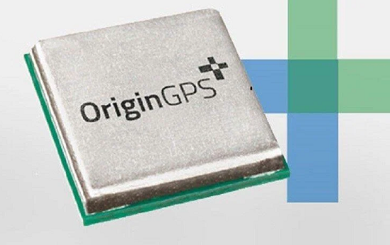
New products include a low-profile GPS module, a new-gen dual-frequency GNSS module and a super-mini IoT tracker
Photo: OriginGPS
OriginGPS will showcase new GPS and GNSS modules and a tiny tracker at Embedded World, Nuremberg, June 21-23, and at Electronica, Munich, Nov. 15-18.
Among products exhibited are:
the 7 x 7 mm ORG4572-MK05 GNSS module with a 10-Hz update rate
the new generation dual-frequency L1+L5 ORG4600, which provides centimeter-level accuracy with RTKLIB and NMEA with raw data in parallel
a low-profile GPS antenna module, the ORG1511-MK05
a new waterproof super-mini tracker measuring 4.9 x 2.7 x 1.4 cm and equipped with magnetic charging
high-performance solutions for a myriad of industries, from fish finders and oil and gas monitors to cargo tracking and gun control.
OriginGPS specializes in miniature GNSS modules and cellular internet of things (IoT) systems. Its high-performance solutions are suitable for every type of device designed to monitor and track valuable assets, whether stationary, in motion or both.
OriginGPS today offers a broad range of high-efficiency solutions, including traditional miniature GNSS modules and cellular IoT systems and devices to dramatically shorten time to market.
“When we realized that the component shortage was here to stay a while, we revisited our roadmap and added two GNSS modules, the ORG1510-MK05 and the ORG4572-MKO5,”said Amir Benyamini, vice president of research and development, OriginGPS. “These new models are based on available chipsets and boast a lead time of just 12 weeks. We also offer a similar lead time for our dual-frequency module.”
Current u-blox GNSS platforms — from u-blox M8 and beyond — support the recently completed BeiDou navigation satellite system modernizations, improving the availability of GNSS positioning services.
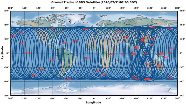
The opening ceremony of the BeiDou-3 global navigation satellite system (GNSS) was held in Beijing on July 31, officially celebrating the expansion of coverage offered by the critical Chinese space infrastructure to a global user base.
As a global supplier of GNSS positioning and wireless communication technologies, u-blox has been driving technological innovation and deeply involved in the Chinese market for many years.
Tests conducted across China and Europe have shown that including the BeiDou system can improve the positioning accuracy of GNSS receivers when multiple navigation satellite systems are tracked concurrently. When signals are partially obstructed, positioning accuracy can be significantly improved by incorporating the BeiDou system.
Data shows that in 2019, the overall output value of the Chinese satellite navigation and location service industry reached nearly 345 billion yuan, an increase of 14.4% over 2018, with the output value expected to exceed 400 billion yuan in 2020.
Graphic: China Satellite Navigation System Management Office Test Evaluation Research Center
Additional Services Provided by BeiDou
The BeiDou system provides a suite of additional services, including satellite and ground-based augmentation services, precise single-point positioning, precise timing and global short message services, laying a solid foundation for BeiDou’s ubiquitous navigation and tracking applications.
Applications of GNSS technology continue to diversify, leveraging the all-weather, all-time, tracking, navigation and timing services it offers. GNSS technology is penetrating deeper into traditional industrial verticals, such as agriculture, forestry, animal husbandry and fishery, power and energy, as well as in railway and air transportation, including their infrastructure construction and management.
At the same time, GNSS technology has become an indispensable and “smart” factor in emerging application fields such as the internet of things and the “internet of vehicles,” as well as in innovative applications such as autonomous driving, automatic parking and automatic logistics, and is now commonplace in many industrial and consumer use cases.
“U-blox has been closely following the modernization of the BeiDou navigation system and is ready to work with partners in various industries to promote the expansion of industry applications, expand emerging markets and jointly create a green industry ecosystem,” said Hamilton Chen, China country manager at u-blox.
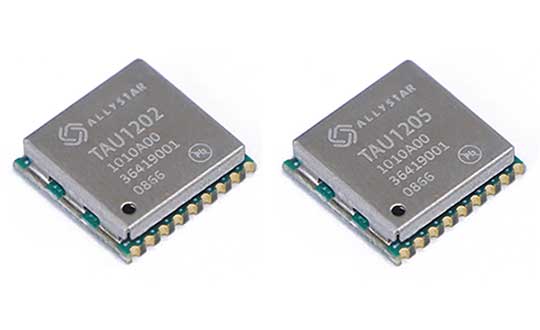
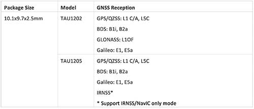
Allystar Technology Co. Ltd. has launched the dual-band multi-GNSS modules TAU1202/TAU1205, which support both the L1 and L5 bands to enhance sub-meter positioning accuracy. Constellations received include GPS, Galileo, GLONASS, BeiDou, QZSS and IRNSS.
Besides the L1 band, TAU1202 and TAU1205 also support L5/B2a/E5a, which are expected to have lower noise and significantly reduced multipath mitigation because of the higher chipping rate of L5 signals relative to L1 C/A code.
Chart: Allystar
TAU1205 supports IRNSS (NavIC) which makes it suitable for navigation in the urban areas of India and the Middle East, as there are seven NavIC satellites with a higher elevation than both GPS and Galileo satellites.
Photo: Allystar
Powered by Allystar Cynosure III GNSS chipset and with built-in low-noise amplifier and surface acoustic wave (SAW) filter, TAU1202 and TAU1205 provide higher sensitivity, ensuring exceptional acquisition and tracking performance even in weak signal areas.
Based on 40-nm manufacturing processes of the Cynosure III GNSS chipset and state-of-the art internal PMU, TAU1202/TAU1205 comes with very low power consumption at less than 40 mA.
Multiple communication interfaces including UART and I2C simplify customer designs and provide a better time-to-market for customers’ products.
“Due to its excellent performance in urban area, compact design and concurrent multi-GNSS reception, TAU1202/TAU1205 has become a popular selection for vehicle and asset tracking in worldwide,” said Zhang Yanping, Allystar product line manager. “The launch of TAU1202/TAU1205 shows Allystar continues to drive GNSS evolution in thte navigation mass market.”
Allystar started TAU1202/TAU1205 mass production in the second half of 2019.
When I was a kid, two of my hometown’s burger drive-ins attracted the hungry attention of my sister and myself, causing us to hound our parents to take us “out to dinner” upon the slightest pretext. Only one of them, however, boasted a sign claiming “400 million served.”
This was a staggering number to an eight-year-old. I hypothesized that everyone in the world must have consumed several by now — a very good argument for me to have one tonight.
The desire to provoke similar reasoning could form part of the motivation for the China Satellite Navigation Office to announce that sales of BeiDou-based chips have exceeded 80 million. Ran Chengqi, director of the CSNO, delivered the number in a report on the 10th China Satellite Navigation Conference held in Beijing on May 22.
“It would be stretching a point to say that satnav chips are the burgers of the future, but it’s not an exaggeration to assert that they are becoming a commodity on the world market.”
Now, 80 million falls short of 400 million, but that next hurdle is well within reach, considering the size, potential and explosive growth of the Chinese market, to say nothing of others along the Great Belt and Road, a global development area of infrastructure development and investments in 152 countries and organizations in Asia, Europe, Africa and the Middle East.
The BeiDou number pales in comparison to the 3.15 billion units of total GNSS chips that global consumption is expected to hit in 2022. By a reasonable projection, BeiDou-enabled chips will by then constitute a major if not the lion’s share of that number.
Of course, GPS-enabled chips will form a greater majority, if not the totality. All chips will — unless the world radically changes — be GPS-enabled to start, and then have some combination of other GNSS in addition.
Big Numbers. Ran Chengqi further said that 22-nanometer dual-frequency BeiDou chips are ready for commercial applications.
According to the China Global Television Network, 116 new positioning-capable cellphone models applied to enter the Chinese market in the first quarter of 2019; 82 of them carry BeiDou-enabled chips. The latest government report on the scale of China’s satnav industry anticipates it will reach 400 billion yuan (US$ 57.8 billion) by 2020.
The news agency stated that more than six million vehicles in 36 cities use BeiDou; long-distance operations and precision farming help raise output by 5% while saving 10% of fuel costs; and more than 70,000 fishing vessels employ BeiDou’s short messaging service.
BeiDou’s rapid success in a relatively short term echoes that of GPS and GNSS in general. It would be stretching a point to say that satnav chips are the burgers of the future, but it’s not any exaggeration or distortion to assert that they are becoming — if they have not already become — a commodity on the world market.
By the way, those golden arches have since 1994 stopped counting and updating their published burger tally. All the signs simply say “billions and billions served.”
A roundup of recent products in the GNSS and inertial positioning industry from the December 2018 issue of GPS World magazine.
OEM
Combination antenna
Long-range connectivity
Photo: Molex
The Molex highly compact 2.4/5-GHz combination GPS/Wi-Fi ceramic antenna is designed to be a cost-competitive solution covering the full GNSS band, 1.561 to 5.85 GHz. The triple-band ceramic antenna has Wi-Fi HaLow compatibility and is interference-resistant, supporting larger but lower (900-MHz) frequency ranges than 2.4/5-GHz connections. It also operates with lower power over longer ranges than 2.4/5-GHz Wi-Fi. Advanced Wi-Fi applications the internet of things, connected cars, smart homes and smart cities.
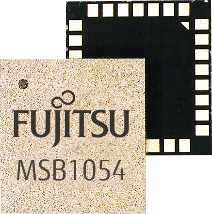
The MSB1054 multi-receiver module requires no external components, meeting needs of smartwatches, fitness trackers, logistics and navigation. Its Flash memory saves navigation data to optimize performance and provide a hot start. The ability to receive signals from several satellite systems significantly reduces the time to first fix. The module provides a built-in RF-front end (SAW filter, low-noise amplifier) as well as a temperature-compensated crystal oscillator (TCXO), so no external component is required other than an antenna. It measures 5.8 × 6.2 × 1 millimeters and uses 3.4 mA current in low-power mode, such as for tracking.
The GE310-GNSS is an internet of things (IoT) module with GSM/GPRS, multi-constellation satellite positioning and Bluetooth functionality in a 270-millimeter-squared form factor. It meets European demand for GSM/GPRS compact form factors and is part of Telit’s migration-support program that helps customers leverage 2G’s low cost and broad coverage while preparing for 4G and 5G. The GE310 enables OEMs and system integrators in asset management, utilities and telematics to meet the strong demand for low-cost, highly compact devices without tradeoffs in performance, reliability and functionality, particularly in regional markets such as Europe, where 2G is forecast to remain in strong growth in number of IoT connections for many years.
With multi-sensor fusion positioning and orientation
Photo: Unicore
The CLAP-B multi-GNSS/MEMS integrated inertial navigation board features a miniaturized high-performance inertial measurement unit (IMU) on a compact high-performance GNSS board. The high-accuracy GNSS positioning coupled with a high-precision gyro and accelerometer provides stable, continuous 3D position, velocity and attitude, as well as original acceleration and angular velocity measurements, even in GNSS-denied environments. CLAP (Concurrent Localization & Attitude Pilot) technology is a high-precision multi-sensor fusion positioning and orientation technology developed by Unicore. The board is compact, light weight and has low power consumption. It is designed for ease of integration and mass production, and is suitable for autonomous driving, smart surveying and UAVs.
The UNI-GR1 RTK GNSS receiver offers highly accurate heading and positioning output. It can be connected to any device through Wi-Fi, mobile data, radio, USB or serial cable. It simultaneously tracks GPS L1/L2/L5, GLONASS L1/L2, Galileo E1/E5a/E5b and Beidou B1/B2/B3 on 432 channels. The receiver has a built-in level, a LED ring driven by a nine-degrees-of-freedom inertial measurement unit. Users can configure numerous settings such as real-time kinematic, or begin surveying immediately with a smartphone or laptop.
Dynamic tilt functionality has been added to the Trimble SPS986 GNSS smart antenna. The dynamic tilt upgrade allows for faster data collection to enable construction surveyors to create larger digital terrain models faster and with improved accuracy. It can capture higher accuracy measurements on steeper slopes from a moving vehicle and more accurate volume measurements to save time and money on material planning. The dynamic tilt measurement mode also auto-measures antenna height. From inside the vehicle, contractors can set the height of the antenna and quickly interrogate surface models using the real-time 3D surface display in Trimble Siteworks field software.
The Skycatch Edge1 is an on-premise data processing and GNSS base station optimized for the Skycatch Explore1 and DJI Phantom 4 RTK drones. Field teams can fly a drone, process the data and receive centimeter-level data output in 30 minutes or less, directly to a tablet, without the need for internet or cellular connectivity. 2D maps and 3D point clouds can be shared from the tablet. The Edge1 includes built-in WiFi, LTE and reliable sub-5-centimeter accuracy, and delivers high-quality data output. It is also capable of running deep learning algorithms to extract more insights from collected data in near real time.
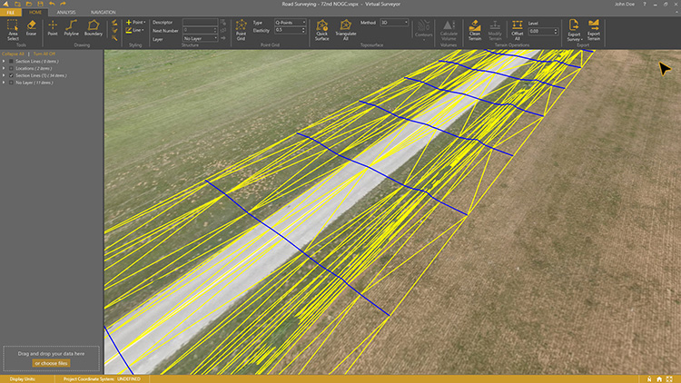
Drone surveying software Virtual Surveyor now eliminates the need for clients to use third-party applications to prepare data for processing. Version 6.1 handles on-the-fly projections that previously required a separate software package to set the data in the proper coordinate system. It bridges the gap between UAV photogrammetric processing applications and engineering computer-aided design (CAD) packages. The software generates an interactive onscreen environment with UAV orthophotos and digital surface models where the surveyor selects survey points and breaklines to define the topography, creating highly accurate topographic products for CAD input up to five times faster than otherwise possible. Surveyors can drag and drop all kinds of files into Virtual Surveyor: points, raster, vectors and point clouds. The point clouds are converted to a DSM for manipulation and processing, dramatically accelerating the time required to generate the CAD model.
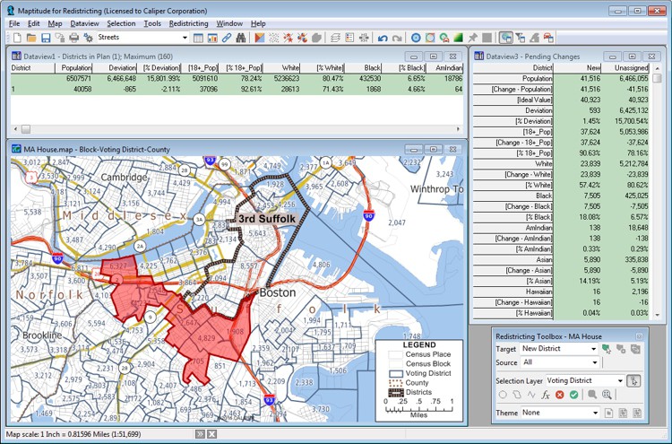
Includes Efficiency Gap Measure to explore redistricting problems
Screenshot: Mapitude
Maptitude for Redistricting is a professional tool for political redistricting. Maptitude provides measures and reports that support the creation of fair and balanced districts, and regularly enhances the software. Maptitude was used to democratize redistricting in California and is used by redistricters from independent commissions, non-profits, and civil rights groups, to the courts and political parties.
Stockpile measurements are up to 80% more accurate
Photo: DJI
The DJI Mavic 2 Pro drone is now part of the Kespry stockpile measurement solution for mining and aggregates companies. Kespry’s stockpile measurement solution produces data up to 80% more accurate than manual measurement. All of the survey data is stored in a central cloud application, accessible for analysis by the entire team. Large aggregates and mining companies can standardize and capture stockpile data across all their sites in the Kespry platform, while using Kespry 2s or DJI Mavic 2 Pro drones.
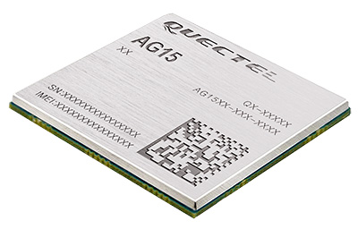
Designed for next-generation automotive applications
Image: Quectel
The automotive-grade C-V2X module AG15 features the Qualcomm 9150 C-V2X chipset paired with Quectel LTE module AG35. It is designed to meet the telematics and vehicle-to-everything (V2X) connectivity requirements of autonomous driving and road safety. It features a built-in multi-constellation high-precision GNSS (GPS/GLONASS/BeiDou/Galileo/QZSS) receiver with additional support from satellite-based augmentation systems (SBAS) and Qualcomm 3D dead-reckoning technology, which improves positioning accuracy and speed while simplifying customer designs. It is designed to allow low-latency, highly reliable and highly dense data exchange between vehicles and their surroundings, enabling effective information sharing among road users to avoid collisions, thus improving automotive safety, automated driving and traffic efficiency.
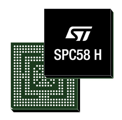
The SPC58 Chorus H microcontroller (MCU) line can run multiple applications concurrently to allow more flexible and cost-effective vehicle electronics architectures. The line is designed for high-end body, networking and security applications such as gateways, body-control modules, battery management and ADAS safety systems. The line has three high-performance processor cores, more than 1.2-MB RAM and powerful on-chip peripherals. The MCU securely delivers updates over the air for vehicle powertrain, body, chassis and infotainment features. With high security and large on-chip code storage, ST’s Chorus automotive microcontroller is a gateway/domain-controller chip capable of handling major OTA updates securely. Two independent Ethernet ports provide high-speed connectivity between multiple Chorus chips throughout the vehicle and enable responsive in-vehicle diagnostics.
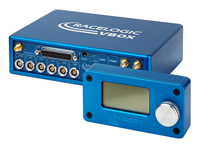
The VBOX 3i RTK is a real-time-kinematic-enabled version of the VBOX 3i dual antenna that can be used in conjunction with an RTK differential base station to obtain ±2-centimeter positional accuracy in real time at 100 Hz. The data logger combines the advantages of a twin antenna GPS setup with GLONASS satellite tracking. It can be used in vehicle tests where positional accuracy and repeatability are of key importance, such as lane departure testing, distance to a fixed object or precise mapping. The VBOX 3i RTK comes with the VBOX manager, a display enabling users to change dynamic modes and filter settings, set up slip angle data and define antenna locations.
The StarLink TrackerWi‑Fi advanced vehicle-tracking device combines u-blox GNSS, 4G and Wi-Fi technology, eliminating the need to equip vehicles with a separate mobile Wi‑Fi hotspot. StartLink is suitable for applications for connected cars, telematics, vehicle diagnostics, fleet management, vehicle security, usage-based insurance, and rental and leasing service companies. With the Wi‑Fi hotspot, users can tap into cellular 4G to transfer telematics data to the fleet manager and send real-time data to the driver’s smart device or infotainment system.
The Notilo Plus team with the iBubble. (Photo: Notilo Plus)
Notilo Plus has launched iBubble, a fully wireless, autonomous and intelligent underwater drone that can be used for search-and-rescue operations, naval or underwater infrastructure maintenance, and subsea patroling. iBubble can accompany divers for up to an hour and down to 197 feet depth, enabling superior underwater imaging. The remotely operated vehicle (ROV) was designed using a patented underwater localization technology, which is mainly based on acoustic signal transmission and image recognition (video tracking). By combining these technologies, iBubble is able to locate precisely its target underwater and shoot stable footage. The iBubble is equipped with an obstacle avoidance system, real-time image recognition, a stabilization system and direct surface control.
Anafi Work is an ultra compact tool for professionals, helping them make informed decisions using the drone’s aerial insights. Anafi Work includes the advanced Anafi drone equipped with an innovative imaging system, a 4K/21MP camera with a 180° vertical orientation, allowing users to capture images of inaccessible areas.The drone operates for 1 hour and 40 minutes with its 4 USB-C smart batteries. It can be transported anywhere in a compact shoulder bag. Professionals can create 3D models of buildings, quickly and easily, using a one-year subscription to Pix4Dmodel.
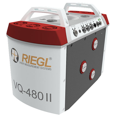
The Riegl VQ-480 II and VQ-580 II are designed for airborne applications at mid-altitudes for use on both manned and unmanned aircraft. The new Mark 2 designs of previous models improve both performance and user-friendliness. Both offer a measurement rate of up to 1,250,000 measurements/second and a 75-degree field of view of suitable for corridor mapping, city modeling and applications in agriculture and forestry. Weighing approximately 10kg, they are ready for integration into helicopters and unmanned UAVs with a higher payload capacity. The VQ-480 II and VQ-580 II are prepared for smooth GNSS/IMU integration, offer interfaces for up to five optional cameras, and are have built-in and removable storage.The VQ-480 II works at a laser wavelength of 1550 nm; the VQ-580 II at the1064 nm wavelength suited to measure on ice and snow.
DroneNode is a portable, compact and inconspicuous counter-drone jamming device that law enforcement can use at large outdoor events without raising public concern (it is not yet authorized for use in the U.S.) It can simultaneously jam 2.4 GHz, 5.8 GHz and GNSS L1 and L2 bands up to one kilometer, causing drones to return to their point of origin or land. It is also effective against swarm attacks. Emergency broadcasts, cellphone communication and other dedicated channels are unaffected.
Skydio R1 users now have the ability to follow cars. New modes include Car Follow, improved Lead Mode, and other improvements throughout the system, which is built on top of the Skydio Autonomy Engine. The engine operates 13 cameras, enabling it to map and understand the world in real time, allowing it to be fully autonomous and independently capture video footage. Its Nvidia Jetsonl AI runs neural networks that trained for the Car Follow feature on datasets of automobile images.
Septentrio has released version 4.2 firmware for the AsteRx4, AsteRx-U and the newly launched AsteRx-m2. The 4.2 firmware brings higher output rates, low and constant latency, support for TerraStar-C and a built-in NTRIP caster.
AsteRx-m2 UAS receiver.
The 4.2 firmware targets machine control applications delivering higher output rates with consistent and low latency. Maximum output rates have increased on all platforms: up to 100 Hz for the AsteRx4 and AsteRx-m2 and 50 Hz for the AsteRx-U, with latencies better than 10 ms and 20 ms respectively.
TerraStar-C is now supported, bringing precise point positioning (PPP) horizontal position precision to 4 cm. In addition, Septentrio algorithms deliver fast PPP re-convergence making PPP even more attractive for positioning in difficult environments.
For the AsteRx4 and the AsteRx-U, the 4.2 firmware enhances ease-of-use by including a built-in NTRIP caster. Correction data from the receiver is available for up to 10 NTRIP clients (or rovers) over the internet. The caster supports up to three mount points and can also rebroadcast correction data from a remote NTRIP server.
“For machine control and automation, Septentrio receivers have unique low-latency behaviour which is constant and independent of the update rate.” stated Francesca Clemente, Product Manager at Septentrio. She continued: “The 4.2 firmware demonstrates Septentrio’s commitment to advancing performance and functionality of its products.”