Tag: GNSS OEM board

  • ComNav GNSS OEM Boards Used in China Driving Test System

    Along with booming auto sales in China has come an increase in auto accidents, which has been a headache for the Chinese government. According to police statistics, most of the accidents in the past couple of years were being caused by new  drivers, who have been ignominiously dubbed “road killers.”

    One year ago, the China Police Ministry decided to change the method of licensing new drivers by using stricter methods for training and testing. The new system also was designed to avoid cheating.

    Under to the new testing system rules, the high-accuracy GNSS receiver became the ideal sensor to enforce the new testing, according to ComNav, a ShangHai-based OEM receiver maker. By offering a turnkey solution, from November 2012 to July 2013 ComNav sold more than 5,000 GNSS OEM boards/receivers for driver testing — the major share of that market.

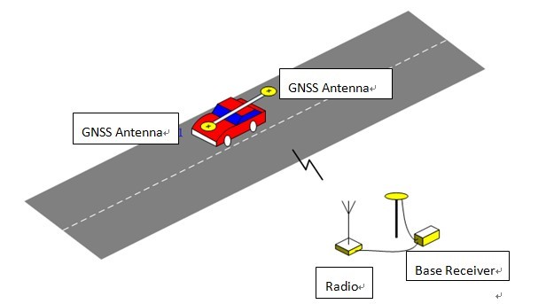
    The system uses the real-time kinematic (RTK) method to establish the accurate heading and position of the car, with a ComNav M600 GNSS receiver. A base station sends differential data to a rover installed on the car. With the help of 3G or Wi-Fi, the real-time data is transmitted to the control center. Examiners can then can judge whether the car is in the right area. Both the trainee and system will know the testing results without delay.

    Surveying the testing place, marking the testing area, and measuring the car shape need to be done before the installation.

    ComNav Technology Ltd. is a high-accuracy positioning solutions supplier that focuses on high-accuracy GNSS core technology R&D, manufacturing and marketing. ComNav is the first Chinese high-accuracy GNSS OEM board manufacturer and producer of a GPS+BeiDou OEM board.

    System diagram.
    System diagram. Source ComNav
    Side parking test.
    Side parking test. Source ComNav


  • Broadcom Launches GNSS Chip with Geofence Capabilities

    Broadcom Corporation has introduced the BCM47521, a GNSS chip with architecture that enables geofence capabilities while preserving battery life. According to Broadcom, the new chip opens the door to always-on location-aware applications such as social networking, place-based mobile commerce and local merchant advertising.

    Broadcom will showcase its GNSS innovations at the upcoming Mobile World Congress show in Barcelona, February 25-28.

    A geographical region of interest (“geofence”) is being used by many new and innovative location-aware applications. The geofence feature enables the application to receive a notification when a user enters or exits a virtual perimeter. However, the implementation of this feature in traditional architectures is not viable, as the applications processor needs to run constantly, causing rapid drain to the device’s battery. Broadcom’s new BCM47521 overcomes this issue, making it possible to continuously monitor geofence areas while consuming 60x less battery power.

    “The astounding growth of mobile devices is driving new opportunities for inventive applications that deliver valuable location-aware information,” said Scott Pomerantz, Broadcom vice president and general manager, GPS. “With the BCM47521’s low-power geofence mode, Broadcom is driving the next wave of system power consumption innovation that will allow OEMs to incorporate features that differentiate their mobile offerings and make location-aware, always-on applications a reality.”

    The BCM47521 chip also provides multi-constellation support by simultaneously collecting data from GPS, GLONASS, QZSS and SBAS, and using the best received signals, resulting in faster searches and more accurate real-time navigation, Broadcom said. Broadcom’s multi-constellation technology, coupled with advanced signal processing, provides faster positioning performance for improved user experience, especially in challenging urban environments where buildings and obstructions can dramatically impact accuracy and time-to-first-fix.

    A key feature is the 60x better system power efficiency versus a host-based architecture. An advanced host-offload mode monitors geofences in the background and only activates the applications processor when there is a trigger event, and smart algorithms adapt in real-time as the user gets closer to a geofence boundary.

  • Trimble Introduces Compact Receiver for Mobile Positioning Applications


    Trimble has introduced at the ION GNSS Conference in Nashville the Trimble BD920-W3G receiver and communication module. As part of Trimble’s GNSS OEM portfolio, the new compact module features centimeter-level, real-time kinematic (RTK) positioning capabilities coupled with Wi-Fi, Bluetooth and cellular that deliver flexible communication options for precise, mobile positioning. The BD920-W3G module’s connectivity and configuration ease allow system integrators and OEMs to easily add GNSS centimeter-level positioning to specialized or custom hardware solutions, Trimble said.

    “The OEM and system integrator communities demand high performance, reliability and support for their positioning solutions,” said Dale Hermann, director of marketing and sales. “The Trimble BD920-W3G delivers the latest in GNSS and communication technology in an easy-to-integrate form factor for demanding conditions and applications such as field computing, port automation, and lightweight robotic or unmanned vehicles.”

    The Trimble BD920-W3G module has been designed for applications requiring centimeter accuracy in a compact package. By integrating wireless communications on the same module, the task of receiving and transmitting data such as RTK corrections is greatly simplified. A single intuitive Web interface allows a variety of use cases to be supported. In addition to GNSS base and rover setups with Wi-Fi or UMTS modem, the module also allows simultaneous customer access to the Internet.

    The dual-frequency GPS/GLONASS BD920-W3G provides customers with a more integrated product that can reduce their integration effort and time to market. Wireless communications and Ethernet connectivity are available on the module to allow high-speed data transfer and configuration via standard Web browsers. USB and RS232 are also supported. By tightly integrating communications and GNSS receiver, integrators can reduce costs and integration complexity, the company said.

    The Trimble BD920-W3G is expected to be available in the first quarter of 2013 through Trimble’s Precision GNSS + Inertial sales channel worldwide. The BD920-W3G can be viewed in 3D on Trimble’s 3D Warehouse by SketchUp. OEMs and integrators can also download a 3D model into their applications. For more information, visit www.trimble.com/gnss-inertial.

  • Compact Modules for RTK GNSS

    Hemisphere GPS announces the Eclipse P300 and Eclipse P301 OEM modules — its next-generation high‑performance compact modules for RTK GNSS applications. Based on new Hemisphere GPS multi-function application firmware and Eclipse GNSS multi‑constellation technology, P300 and P301 provide the ability for tracking commercially available GNSS signals for precise positioning.

    P300 is a drop-in board replacement for Hemisphere GPS’ successful Crescent L1 board as well as the first‑generation miniEclipse P200 GPS-only OEM board. P301 is the company’s 20‑pin OEM module configured as a drop-in replacement for a different industry standard interface. Eclipse P300 and P301 improve GNSS positioning performance, particularly with RTK applications, through Hemisphere GPS’ patent-pending SureTrack technology. Benefits include extended and more robust RTK solutions as the rover RTK receiver will process all available signals even if they are not common with the base receiver. RTK solutions are therefore better maintained in challenging environments, with baselines of up to 50 km, and reacquisition times are improved resulting in more robust overall performance, the company said.

    P300 and P301 are designed for OEM system integrators who demand the highest level of multi-frequency positioning, accuracy, fast initialization time, and GNSS RTK solutions. Hemisphere GPS’ miniEclipse series includes a single frequency L1 GPS + L1 GLONASS model named P202. Both series are designed for developing integrated high-precision and control applications for geomatics, survey, machine control, and unmanned vehicle solutions.

    “P300, P301, and P202 all improve upon our already successful miniEclipse OEM modules adding GNSS support to our most compact modules for excellent accuracy and affordability,” said Phil Gabriel, vice president and general manager, Precision Products, for Hemisphere GPS. “System integrators have a wider range of Hemisphere GPS solutions from which to choose to develop world‑class high‑precision products.”

    Measuring 71 mm long and 41 mm wide, miniEclipse allows for easy integration, especially for integrators who are accustomed to Hemisphere GPS’ Crescent and miniEclipse OEM module performance and footprint.

    All miniEclipse modules are available through the Hemisphere GPS Precision Products global dealer network.