U-blox is partnering with ArduSimple, a Spanish company seeking to facilitate the adoption of centimeter-level GNSS technology for mass-market applications.
The companies partnered to develop the SimpleRTK2B single-board computer (SBC). The device, which is built around up to three u-blox ZED-F9P high-precision GNSS receivers, simplifies the development of centimeter-level positioning solutions supporting real-time kinematics (RTK), making the technology accessible to broader audiences.
The SimpleRTK2B-SBC was developed to make RTK technology as close to plug-and-play as possible. In addition to working as a stand-alone solution, customers can program their own applications with the company’s microPython API.
The SimpleRTK2B-SBC delivers mechanical integration with centimeter position on three axes (heading, pitch and roll), outputting on NMEA, RTCM, RS232 and CANBus interfaces via Ethernet, Bluetooth, Wi-Fi and 2G/3G/4G communication. It offers configurable input/output and an inertial measurement unit.
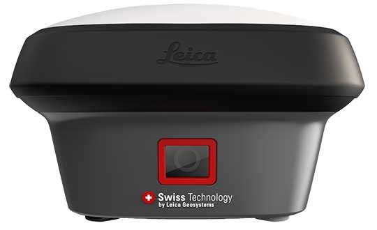
Hexagon AB has introduced the Leica GS18 I, a versatile, survey-grade GNSS RTK rover so powerful it enables surveyors to measure what they see, even structure in difficult-to-reach places, the company said.
It comes equipped with all the innovative functionality of the Leica GS18 T — Hexagon’s calibration-free, tilt-compensating GNSS solution immune to magnetic disturbances, plus the power of survey-grade visual positioning.
Through sensor fusion of GNSS, motion (IMU) and image (camera) technology, the Leica GS18 I enables the measurement of points from images. The ability to capture and measure sites via images goes far beyond the advantages of the GS18 T, which introduced the quick and convenient ability to measure points in spaces that cannot be measured with vertical poles, such as building corners, walls and points underneath obstacles (for instance, cars).
With the Leica GS18 I, professionals can now map areas that are difficult to reach physically, such as trenches, high power lines and busy roads, or blocked from GNSS signals, such as areas underneath bridges or canopies — safely and effortlessly from a distance.
“With the Leica GS18 I, mapping and surveying just got simpler, safer and more productive than ever before,” said Ola Rollén, Hexagon president and CEO. “The ability to quickly document an entire area of interest without the need to switch between tools or manoeuvre through obstacles frees up equipment and crews. Additionally, the simple and intuitive workflow of the Leica GS18 I brings the versatility of visual positioning to new user segments and applications — from utility service providers to crash scene investigators.”
The Leica GS18 I enables users to measure hundreds of points within minutes. Integration with Leica Captivate field software enables intuitive onsite point measurements and quality assurance from the field.
Further measurement of the captured images is supported by integration with Leica Infinity office software, which also enables the creation of automatically registered and referenced 3D point clouds from the images in standard export formats for use in a variety of point cloud software.
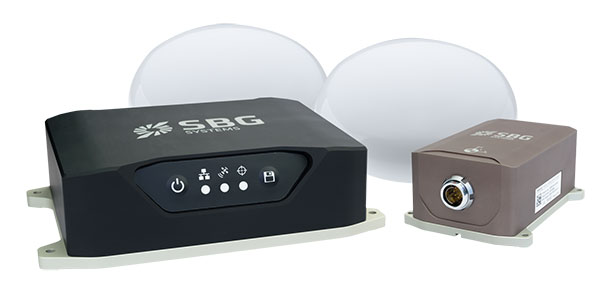
SBG Systems is launching the Navsight Land & Air Solution, high-performance inertial navigation designed to make surveyors’ mobile data collection easier, whether for mobile mapping, GIS or road inspection.
SBG Systems will release the Navsight Land & Air Solution at the Intergeo show in Frankfurt, Germany, Oct. 16-18.
The solution consists of an inertial measurement unit (IMU), available at two different performance levels, connected to Navsight, a rugged processing unit embedding fusion intelligence and a GNSS receiver. It also has connections for external equipment such as lidar, cameras or computer.
Photo: SBG Systems
The Navsight Land & Air Solution is the result of more than 10 years of experience in the mobile positioning industry, especially in the unmanned industry where position reliability is mandatory. SBG’s fusion algorithms allow the company to get the best performance from inertial, odometer and GNSS technologies; exclude false GNSS fixes; and improve the trajectory in complicated areas such as urban canyons, forests and tunnels.
According to the company, the Navsight Land & Air Solution supports all GNSS constellations, real-time kinematic (RTK) and precise point positioning services such as Omnistar and TerraStar.
SBG IMUs are easy to install, the company said. The sensor alignment and lever arms are automatically estimated and validated. Once connected to the Navsight processing unit, the web interface guides the user to configure the solution. A 3D view of the vehicle shows the entered parameters so that the user can check the installation. By choosing the vehicle, such as a plane or a car, the inner algorithms are automatically adjusted to the application. The Navsight unit also integrates LED indicators for satellite availability, RTK corrections and power.
INS/GNSS Post-Processing Software. Qinertia, the SBG post-processing software, provides access to offline RTK corrections from more than 7,000 base stations in 164 countries. Trajectory and orientation are greatly improved by processing inertial data and raw GNSS observables in forward and backward directions.
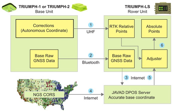
JAVAD GNSS has integrated its Justin software suite, including Verify Base-RTK (VB-RTK) with its Triumph-LS Rover receiver, carrying six different RTK engines, and Triumph-1 or Triumph-2 base units, to make GNSS data collection easier yet more reliable.
The combination of the J-Field onboard data collection of the Triumph-LS working with the Justin reduction software establishes the project coordinate system with little effort and good confidence in the user’s field data, the company said.
The Javad Data Processing Online Service (DPOS), built in the Justin software system, works directly with the National Geodetic Survey’s Continuously Operating Reference Station (NGS CORS) system to calculate and establish the project base station within a known coordinate system.
This system can be based upon the National Spatial Reference System (NSRS) or a localized system. Either way, the user can begin data collection immediately using an autonomous base point, with relative corrections being established to the RTK receiver.
Before VB-RTK, an extra step (and time) was required to occupy the base point, collect a sufficient amount of data, and upload to the NGS Online Positioning Service (OPUS) for data calculations and positional determination. VB-RTK now automates this process, increasing efficiency and reducing errors.
Among the main benefits of the software are the vector data check-verification routines and the ability for the user to easily identify random errors (receiver height input, description codes, and so on).
Justin software enables thorough review of preset parameters and templates to help the user establish a consistent workflow pattern.Additionally, the receiver and software system do not rely on a third-party real-time network (RTN).
Besides knowing exactly where the base station is broadcasting from, there are no data charges from the RTN nor cellular fees. By having the base station within the project area, the system will also provide the user with faster fixes and more accurate information.
Leica Geosystems has released the Leica GS18 T, a fast GNSS RTK rover, as well as the latest versions of Leica Captivate field software and Leica Infinity office software.
Leica made the announcement at Intergeo 2017, held Sept. 26-28 in Berlin, Germany.
The announcement expands the Leica Captivate Experience. With the addition of calibration-free GNSS and various upgrades to the Captivate field software and Infinity office software, users continue the immersive experience with self-learning GNSS and engaging, intuitive software interfaces.
“In my business, speed is the name of the game,” said Manny Sangha, owner of Sangha Geomatics & Land Survey Inc. in Vanderhoof, Canada. ” With my GS16, I’ve been able to reduce time spent on every project. I can only see this getting faster and improving efficiency with the GS18. No longer having to level the pole nor calibrate the system, this is a real value for me and a game-changer in the industry.”
Calibration-free tilt compensating GNSS
According to Leica Geosystems, the GS18 T is the a calibration-free tilt compensating GNSS solution immune to magnetic disturbances.
GNSS measurements can be taken from any position on site, saving users up to 20 percent of time in the field over conventional surveying practices, because they no longer need to hold the pole vertical to level the bubble.
The GS18 T uses precise inertial measuring units (IMUs) and not a compass, so that users can measure with a tilted pole close to buildings, underneath cars and close to metallic objects.
With integrated quality assurance, the GS18 T records exactly how the pole was leveled during the measurement. The GS18 T then stores the values, ensuring measurement traceability and complete quality reporting.
Software updates
Fully supporting the GS18 T, Leica Captivate v3.0 field software and Leica Infinity v2.4 office software now offer users a more immersive means of control on site and at the desk.
Captivate now allows configuration of the GS18 T for all measuring and staking applications and the visualization of tilt compensated measurements. Measured data can be directly imported into Infinity or exported into a variety of formats suitable for CAD packages.
Within Infinity, users can visualise the measured data, including the creation of reports providing full traceability and quality assurance for themselves and their clients.
By Martti Kirkko-Jaakkola, Stefan Söderholm, Salomon Honkala, Hannu Koivula, Sonja Nyberg, and Heidi Kuusniemi, Finnish Geospatial Research Institute (FGI), National Land Survey of Finland
Our real-time kinematic (RTK) implementation, the Public Precise Positioning (P3-Service) project, has achieved horizontal positioning accuracy of 0.5 meters using relatively inexpensive equipment: a commercial off-the-shelf (COTS) low-cost GNSS receiver. The project used FinnRef, the Finnish national GNSS network.
With inter-station baselines on the order of 200 kilometers, FinnRef is relatively sparse in comparison with commercial RTK networks. We used FinnRef as the RTK base station, either in single-base or network RTK mode. Although FinnRef’s main purpose is to maintain the national coordinate system, it is also capable of delivering DGNSS and network RTK data over the NTRIP protocol.
Transport Applications. Horizontal position accuracy of 0.5 meters or better, achieved for more than 90 percent of the time with small, low-cost devices, could be useful in various applications, particularly in intelligent transportation systems.
Current consumer-grade GNSS solutions routinely offer a positioning accuracy in the order of 5 meters, and satellite-based augmentation systems (SBAS) such as WAAS and EGNOS can improve the accuracy to the order of 1 meter. However, this is not adequate for all use cases; in particular, intelligent transportation systems (ITS) require better positioning performance. For instance, a horizontal accuracy of 0.5 meters is needed to reliably identify the lane in which a vehicle is driving. Maintaining inventory of machines, road signs and other infrastructure would also benefit from sub-meter accuracy.
Sub-meter or even sub-decimeter positioning accuracies can be attained with a relatively good reliability in real time if a dual-frequency GNSS receiver and a physical or virtual base station are available. However, such receivers and virtual base station services are currently too expensive to gain popularity in the mass market. Recently, precise point positioning (PPP) has demonstrated that comparable accuracies can be attained without a base station using real-time precise correction data, but its drawback is a long convergence time. In contrast, differential methods utilizing raw base-station observations, such as RTK, converge much faster.
Horizontal position estimation results from a low-cost COTS receiver (right); the green triangle marks the reference position solution.
Network RTK Test. Network RTK performance was tested in a static scenario with the closest physical base station 63 kilometers from the rover receiver. Network corrections were delivered in the PRS representation, and data were logged for 20 minutes at a rate of 1 Hz. The plot above shows the resulting horizontal position errors. The dashed red circle with a radius of 0.5 meters centered at the reference location (green triangle) contains 90.4 percent of the position estimates.
For a full account of the experiments and results described here, see the paper “Low-Cost Precise Posioning Using a National GNSS Network,” presented at ION GNSS+ 2015.
Stefan Wei of Hi-Target Surveying Instrument Co. Ltd. discusses the company’s new V90 Plus GNSS RTK at INTERGEO 2015, which was held Sept. 15-17 in Stuttgart, Germany.
The V90 Plus with Trimble BD970 OEM delivers centimeter accuracy and supports all constellations. The company’s self-developed antenna, based on air dielectric technology, is designed for multipath mitigation.