TDK Corporation has announced Trusted Positioning STRIDE, an embedded pedestrian dead-reckoning (PDR) software solution engineered specifically for wearables — smart watches, head-mounted devices, glasses and compact sensors. STRIDE provides reliable positioning without the power and hardware demands traditionally required for GNSS-based tracking.
STRIDE’s low-power, sensor-agnostic software engine fuses inertial data with GNSS and opportunistic wireless signals, delivering continuous location tracking both indoors and outdoors.
STRIDE runs as embedded software, giving OEMs freedom to deploy positioning without redesigning hardware or relying on cloud connectivity, according to the company. STRIDE processes sensor data in real time, ensures low latency, and can be configured for on-device, companion-device, or cloud-assisted architectures. This flexibility helps manufacturers balance performance, power and form-factor constraints based on their device strategies.
Main features and benefits
Low-power on-device mode: Enables continuous PDR in platforms constrained by power, memory or thermal limits.
Geofencing mode: Allows location-based alerts and boundaries for children’s wearables, personnel safety, or activity zones.
Tethering of sensors: Seamlessly uses GNSS and sensors from a companion phone, reducing hardware demand on the wearable.
Off-device processing: Supports computation on a smartphone or in the cloud for advanced analytics or battery saving.
GNSS duty-cycling: Dramatically extends battery life by activating GNSS only when necessary.
Flexible mounting support: Works across watches, smart glasses, helmets, chest-mounted devices and more.
Embedded and real-time: Runs directly on the device with low latency — no dedicated infrastructure, no specialized hardware
Hardware-independent and sensor-agnostic: Integrates easily with a broad range of IMUs and GNSS receivers.
STRIDE is available immediately for trial evaluation, OEM integration, or companion-device implementations.
A roundup of recent products in the GNSS and inertial positioning industry from the January 2023 issue of GPS World magazine.
SURVEYING & MAPPING
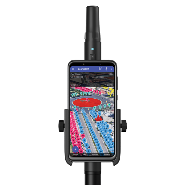
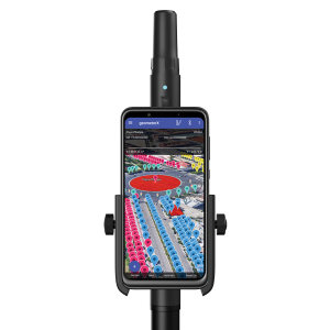
Image: Geometer International
Dual-Frequency Receiver
Receives all GNSS constellations plus SBAS
The Walker RTK is a dual-frequency GNSS receiver (L1, L2) for high-precision coordinate surveying in real-time kinematic (RTK) mode. It comes with a helical antenna, a bracket for attaching a smartphone, and the Geometer SCOUT mobile app. A classic geodesic antenna can be connected through the SMA connector. The Walker RTK has a rugged aluminum alloy casing with a shock-resistant coating, yet weighs only 250 grams. GNSS signals processed by the Walker RTK GNSS receiver include GPS (L1C/A, L2C), GLONASS (L1OF, L2OF), Galileo (E1B/C, E5b), BeiDou (B1I, B2I), QZSS (L1C/A, L1S, L2C) and SBAS (L1C/A). A built-in rechargeable battery provides 24 hours of continuous operation without recharging.
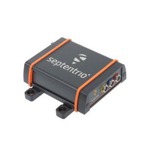
The AsteRx SB3 ProBase creates high-quality measurements for real-time kinematic (RTK) and differential corrections. The IP68-housed GNSS base station receiver features the latest quad-constellation GNSS technology and complements the SB3 receiver family: the AsteRx SB3 Pro rover receiver, the AsteRx SB3 Pro+ rover and base receiver, and the AsteRx SB3 CLAS for the Japanese market. The SB3 ProBase is easy to configure, the company says. It comes with Septentrio’s GNSS+ technologies, including anti-jam and anti-spoofing technology (AIM+) for robustness and reliability. AsteRx SB3 products are pin-to-pin compatible with the AsteRx SB ProDirect receiver and the recently released AsteRx SBi3 GNSS/INS system.
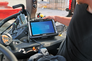
The Algiz 10XR is a rugged 10-inch Windows tablet that combines durability with a GNSS receiver and 5G communications. It was developed for challenging environments in logistics, mining, public transport, public safety, waste management or geographic information systems (GIS). The 10xR is customizable and has a dedicated multiband GNSS u-blox NEO-M8U receiver for accurate positioning as well as untethered dead-reckoning technology. The high-resolution, sunlight-readable 10-inch touchscreen has super-hardened glass and rain-and-glove mode. The tablet also has 4G/LTE high-speed data, Wi-Fi and Bluetooth.
The VZ-600i terrestrial laser scanner has a 3D position accuracy of 3 mm and less than 30 seconds of scan time for high-resolution scans with 6 mm point spacing at 10 m. This enables more than 60 scan positions per hour with real-time registration. Weighing less than 6 kg (13 pounds), the VZ-600i has a 2.2-MHZ pulse repetition rate, three internal cameras and an integrated GNSS receiver. It also includes key features to speed up workflows in indoor and outdoor applications such as architecture, engineering, construction, building information modeling, as-built surveying, forensic and crash scene investigation, archaeology and cultural heritage documentation and forestry.
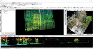
The LP360 Drone software system provides a geospatial-data workflow for UAV lidar and photogrammetry data processing. It provides powerful point cloud visualizations with multiple, synchronized windows. It can transform lidar and imagery data into survey-grade deliverables including visualization, quality checks, classification, analysis and 3D editing. For users of larger datasets, LP360 Geospatial can process captured lidar data or images from any aircraft or mobile sensor and analyze and extract values.
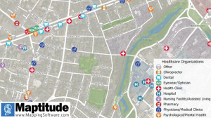
Free library offers data on healthcare, business, traffic
The extensive Maptitude library of free mapping databases has been updated for 2022 and is available for download, supporting insightful business development analysis. The data is available free to users of the latest version of the Maptitude mapping software. The data are also available as shapefile, KML, KMZ or GeoJSON for a fee. Maptitude includes business-critical data such as demographics, boundaries, streets, and the most ZIP Code/postal boundaries. Also available is a catalog of free premium datasets that can be used in other GIS applications, on the web, or in corporate databases.
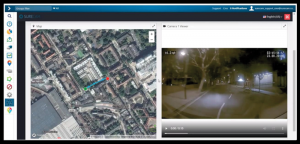
Indoor and outdoor tracking of low-power, small IoT devices
Traxmate is integrating Nestwave GNSS location technology into its asset-tracking platform for seamless indoor and outdoor positioning, tracking and routing of small, low-power and battery-powered devices for the internet of things (IoT). Nestwave’s NestCore IP and NestCloud cloud services enable power-efficient geolocation solutions, while Traxmate (pictured) is a comprehensive data-processing hub that simplifies setup of tracking environments and provides real-time visualization of device location. The resulting geolocation solution is suitable for applications ranging from carrier tracking to tracking individual parcels and packets. Traxmate is simple to use and set up, requires no coding, and provides an out-of-the-box feature set that includes dashboards, alerts and processing rules for taking actions on incoming data. Nestwave’s trackers include ThinTrack, an ultra-low-profile, compact GPS tracking solution that integrates an LTE-M/NB-IoT modem, antenna, battery and SIM into a device that measures 82 mm x 35 mm x3 mm and weighs 15 g.
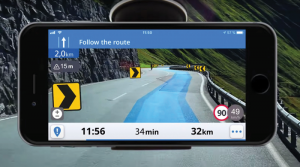
Provides guidance even without an internet connection
The Sygic GPS Navigation app uses a smartphone’s camera and augmented reality to display navigation instructions over the view ahead on the windshield. The head-up display is especially useful at night, enabling recognition of critical speed limit, road work or traffic restriction signs. Cockpit is a powerful tool that shows the real-time performance of the car, measuring the G force and actual speed to help users drive economically. The Dashcam feature records the road ahead and automatically saves the video in case of an accident. An Electric Vehicle Mode locates nearby charging stations.
Enhanced data-based rule implementation for fleets
An enhanced SureCam video telematics integration provides fleet managers with access to new capabilities to keep drivers safe and maximize fleet efficiency. The solution features a method for capturing video footage from SureCam cameras using Geotab’s powerful telematics device and rule-based system. The result is a seamless display of video within the MyGeotab platform. The enhanced SureCam fleet video solution leverages Geotab’s numerous data-based rules, such as improper seat belt usage and speeding. It uses G-force triggered alerts that detect unsafe driving behaviors and automatically captures video footage that can be reviewed later on the MyGeotab platform and alert managers to incidents when necessary. Camera configuration and customized triggers are managed directly within MyGeotab.
Driver 2.0 is a Level 4 production-ready autonomous driving solution that can operate in complex and challenging traffic environments. Demonstrations with Driver 2.0 showed an autonomous vehicle could maneuver around double-parked cars, e-scooters and pedestrians, negotiate oncoming vehicles to calculate the right timing and trajectory to pass busy intersections, and make multiple lane changes and unprotected left turns. In the case of long tail scenarios, the system will alert the remote monitoring center to intervene or take other safety measures. Driver 2.0 includes five solid-state lidar units, eight cameras and other sensors, and a computing platform integrated with a proprietary inference engine. The perception algorithm with sensor fusion can achieve precise object detection up to nearly 220 yards. The planning and control algorithm based on game theory can choose optimal routes and make decisions based on real-time situations when negotiating with oncoming vehicles and other road agents.
Provide improved signal gain for automotive antennas
Two new compounds could improve signal-gain performance compared to ceramics in second-generation automotive GNSS antennas. The new compounds — LNP Thermocomp ZKC0CXXD and LNP Thermocomp ZKC0DXXD — help enable the design and molding of antenna substrates with more complex pattern markings that add effective surface area, a critical factor in enhancing signal capture. They also provide flexibility to produce smaller parts with the same performance as ceramic, or equal-size parts with better performance. The LNP Thermocomp compounds feature electroplating capability, good thermal resistance for reliability, and the design freedom and production efficiency of thermoplastics. Both are well-suited for shark-fin-style and new conformal antenna designs.
SABIC, sabic.com
AUTONOMOUS
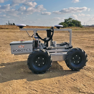
Image: Civ Robotics
Robotic Surveyor
Precisely marks thousands of coordinates per day
The CivDot unmanned ground vehicle (UGV) is designed for civil engineering and infrastructure projects such as solar farms, roadways, data centers, power plants and more. The autonomous surveying robot is designed to increase efficiency, productivity and safety on the job. Augmenting the surveyor’s work, CivDot marks thousands of coordinates per day precisely and efficiently, while delivering layouts faster than traditional methods. Civ Robotics uses Trimble’s high-precision GNSS positioning technology and surveying software.
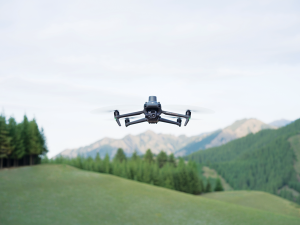
The compact DJI Mavic 3E and 3T drones have been designed for an array of commercial missions. Flight time is 45 minutes. Both models have a real-time kinematic (RTK) module that enables surveying professionals to achieve centimeter-level accuracy with support for network RTK, custom network RTK services, and the D-RTK 2 Mobile Station. The D-RTK 2 Mobile Station is DJI’s upgraded high-precision GNSS receiver that supports all major GNSS, providing real-time differential corrections. The DJI Mavic 3E enables efficient mapping and surveying missions without the need for ground control points. The DJI Mavic 3T is engineered for aerial operations in firefighting, search and rescue, inspections and night missions.
A roundup of recent products in the GNSS and inertial positioning industry from the December 2022 issue of GPS World magazine.
AUTONOMOUS
Flight Controller
Turns a UAV into a connected autonomous system
Photo: Auterion
Skynode reference-design hardware is built with Remote ID in mind, enabling UAV users to comply with the FCC rule Remote Identification of Unmanned Aircraft (Part 89). A built-in connectivity stack with 4G, Bluetooth and Wi-Fi enables automatic real-time data transmission from the UAV to the cloud. Built on open standards, Skynode is flexible and extensible, allowing users to leverage a variety of compatible software and hardware components. The connections enable automatic sending of logs, images and real-time video streams from the field to remote experts.
The VoloDrone is a fully electric, heavy-lift utility UAV with a range of up to 25 mi carrying a carrying a 440-lbs payload. The rotor area has a diameter of 30 ft, and the vehicle is 7.5 ft high. It can be remotely piloted or can fly autonomously on preset routes. Loads can be carried between the legs of the landing gear on standard rack mounts or slung below, or a tank and sprayer could be fitted for agricultural applications. The 18-rotor multicopter platform uses swappable lithium-ion batteries and an in-house flight control system, and benefits from existing development and test of the Volocopter air-taxi.
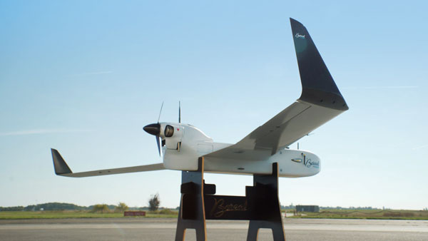
With a wingspan of 4.20 m, the BOREAL NRM remotely piloted aircraft integrates efficient photogrammetry devices for mapping large areas, even in areas inaccessible to traditional mapping aircraft. Its flight-control system is designed for image-capture management and optimal coverage of areas greater than 20,000 ha. The BOREAL NRM offers an overall and precise view of cultivated areas (1 cm to 3 cm per pixel), simplifying crop monitoring and facilitating human intervention in places that require it (such as water stress, treatment of pests).
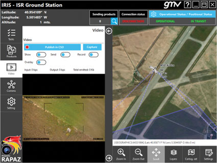
The IRIS unmanned vehicle command-and-control system provides intelligence, surveillance and reconnaissance (ISR) interoperability — essential aspects of any military operation. The IRIS system integrates unmanned vehicles with other command-and-control systems for monitoring and gathering information for a variety of operational scenarios. IRIS uses each unmanned vehicle’s own communication systems and 5G technology to provide situational awareness for decision makers before and during operations. A simplified interface allows integration of sensors and platforms into a command-and-control network, providing interoperability with other command, control, communication and computer ISR (C4ISR) systems. IRIS performed well during NATO’s REPMUS 22 (Robotic Experimentation and Prototyping Augmented by Maritime Unmanned Systems) exercise in September.
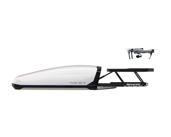
The AtlasNEST UAV system features a docking station to provide fully autonomous 24/7 readiness for infrastructure inspections, emergency situations and security missions requiring shared situational awareness and management. Using the AtlasSTATION interface, an operator sets a target destination, and the lightweight UAV deploys in less than three minutes. Sending a drone to collect visual data and reveal possible problems can help prevent putting personnel in unsafe circumstances. AtlasNEST has built-in artificial-intelligence technologies, including autonomous battery swapping. Using the AtlasSDK, AtlasNEST can be incorporated into current security systems.
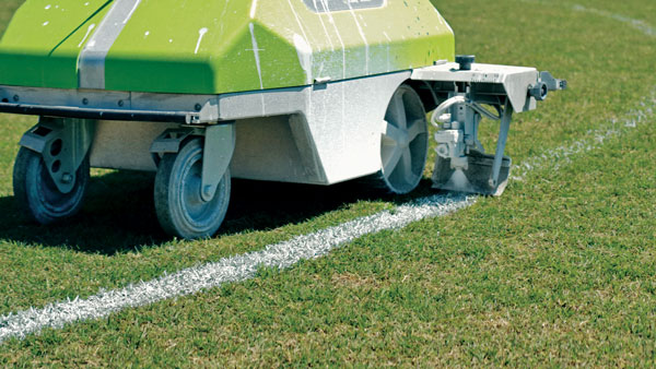
Turf Tank is an autonomous, GNSS-guided line-marking robot built specifically to paint lines on athletic fields. More than 550 Turf Tank robots are deployed across the United States, painting athletic fields at public schools, major colleges and universities, amateur and professional soccer clubs, local parks and recreation departments, and at two National Football League stadiums. The Turf Tank robots can paint a full soccer field in less than 30 minutes, compared to two or three hours for manual painting. Similarly, the robot can paint a football field in two or three hours compared to eight to 10 hours to paint a football field. The robots are eco-friendly — they’re powered by rechargeable batteries and use far less paint than most older paint machines.
The Autel EVO II Pro Series combines Carlson’s software and hardware surveying and mapping solutions with a UAV from Autel Robotics. The Carlson suite is designed to take professionals throughout a project’s lifecycle: setting ground control points with the Carlson BRx7 GNSS receiver and RT4 data collector with SurvPC field software, the drone flight, PC photo and data processing, and creating finished plans in CAD.
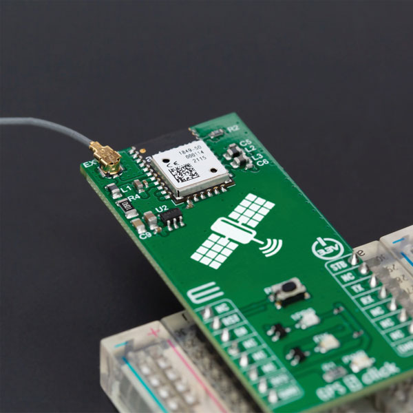
The GPS 5 Click is a compact add-on board that provides users with positioning, navigation and timing (PNT) services. The board features the M20050-1, a GPS module using the MediaTek MT3333 flash chip and an Antenova GNSS receiver for optimum performance. The receiver tracks three GNSS constellations concurrently (GPS + Galileo + GLONASS or GPS + Galileo + BeiDou) and has configurable low-power modes operating from a 3.3V power supply. In addition to the possibility of using an external antenna, backup power, and various visual indicators, the M20050-1 has an accurate 0.5 ppm TXCO ensuring short time-to-first-fix and multipath algorithms that improve position accuracy in urban environments.
Modules GT-100, GT-9001 and GT-90 are time-synchronization GNSS receiver modules compatible with all GNSS systems. The three modules deliver nanosecond precision for 5G mobile systems, radio communications systems, smart power grids and grandmaster clocks. Each suits different applications based on supported frequency bands and output signals. GT-100 supports concurrent L1 and L5 reception and delivers three outputs including 1 pulse per second (1 PPS) synchronized with UTC as well as user-programmable frequencies. The outputs can be set to 10 MHz, 2.048 MHz and 19.2 MHz, reducing time to market and saving costs through reduced component needs. GT-9001 supports L1 and delivers high-stability 1PPS and programmable clocks on three channels. GT-90 supports L1 and provides a 1 PPS high stability output. All models have time stability of 4.5 ns (1 sigma) and are equipped with multipath mitigation to minimize degradation of performance in urban areas.
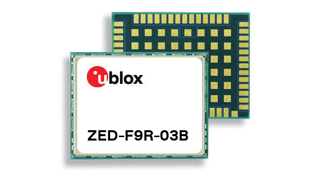
The latest firmware update for the u-blox ZED-F9R high-precision GNSS module adds support for Japan’s QZSS CLAS correction services (ZED-F9R-03B). The ZED-F9R also now supports u-blox SPARTN 2.0 correction data.
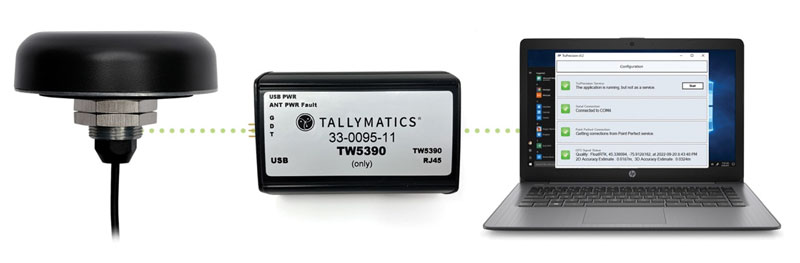
The TW5390 smart antenna has IP network and L-band augmentation service capability. Along with a Tallymatics antenna, it has a high-precision u-blox F9R GNSS receiver and DS9 L-band receiver modules. The combination delivers a reliable and convenient smart antenna yielding <6-cm accuracy, with precise point positioning/real-time kinematic (PPP/RTK) augmentation services via the PointPerfect subscription service. The antenna provides superior multipath rejection with Tallysman Accutenna technology, a low noise amplifier, Tallysman’s eXtended Filtering (XF) technology, which mitigates saturation from nearby RF signals (targeting LTE and Ligado), a tight, measured phase-center offset and low axial ratio, enabling accurate and precise positioning, direct decoding of PointPerfect, SPARTN formatted augmentation packets (u-blox specific)
Tracking enables potential applications and projects
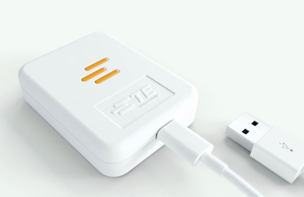
Photo: TE Connectivity
The Lembas LTE/GNSS USB modem provides plug-and-play GNSS tracking as well as LTE and CAT4 network connectivity via a robust USB interface to a variety of small-board computers utilizing the ARM chipset. Through a single-command setup process, users can have GNSS access to a wide variety of projects. The modem has been tested with Raspberry Pi Model B, Odroid XU4 and N2, ASUS Tinker Board, and NVIDIA Jetson Nano.
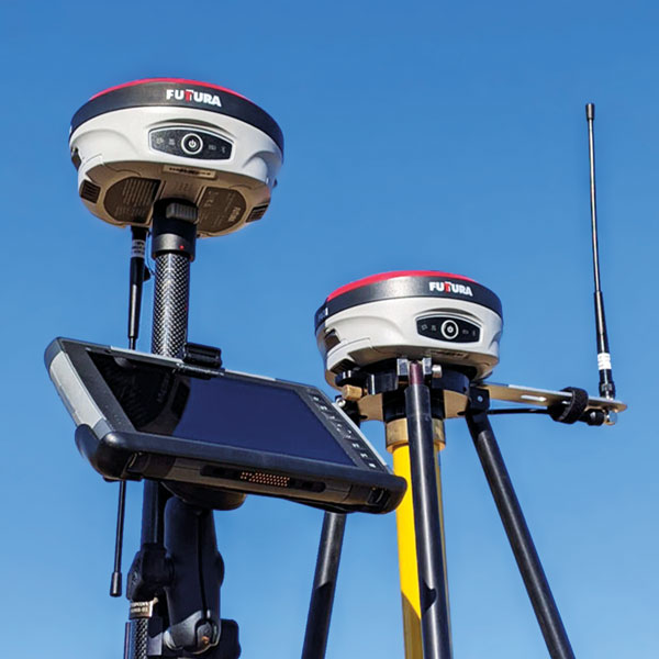
The universal construction site supervisor system is designed to help contractors manage all their job site activities. It includes the SiteMetrix Grade and the multi-frequency, multi-GNSS F631 RTK base and rover. SiteMetrix is user friendly, easy to understand and portable. Contractors can use the Futtura system to localize sites, check grade, configure base stations, set stakes and calculate volumes of material removed. Users will see the benefit of seamlessly performing data collection and layout, all in one easy-to-use application, the company says. The F631 GNSS receiver is powered by SureFix RTK technology, which offers a real-time dual-solution point verification. The F631 GNSS receiver is powered by Hemisphere GNSS’ Athena RTK technology. With Athena, F631 provides state-of-the-art RTK performance when receiving corrections from a static base station or network RTK correction system. With multiple connectivity options, the F631 allows for RTK corrections to be received over radio, cell modem, Wi-Fi, Bluetooth, or serial connection. F631 delivers centimeter-level accuracy with virtually instantaneous initialization times and robustness in challenging environments.
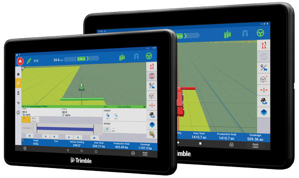
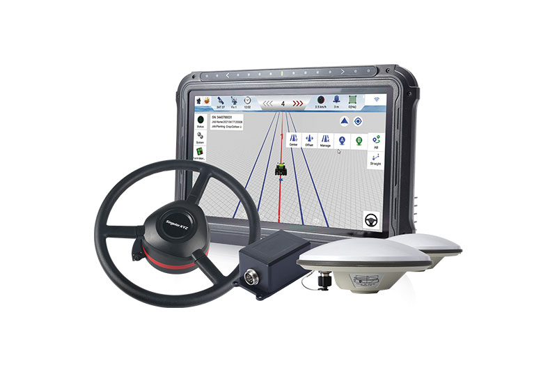
The Trimble GFX-1060 and GFX-1260 next-generation displays for precision agriculture applications enable farmers to complete in-field operations quickly and efficiently while also mapping and monitoring field information in real time with precision. Both displays feature an Android-based operating system and enhanced processing power for controlling and executing in-field work. The new flagship GFX-1260 is a 12-in (30.5 cm) display, while the GFX-1060 is a 10-in (25.6 cm) display, and both are compatible with the Trimble NAV-500 and NAV-900 GNSS guidance controllers. The displays are ISOBUS-compatible, which allows one display or terminal to control ISOBUS implements, regardless of manufacturer. The displays enable farmers to set up and configure their equipment through Trimble’s Precision-IQ field software, including manual guidance, assisted and automated steering, application controls, mapping and data logging, equipment profiles and camera feeds from attached inputs and other internet-based apps.
Enables affordable smart construction upgrades for fleets
Photo: Komatsu
The Smart Construction Retrofit kit turns a conventional Komatsu excavator “smart” with 3D guidance and payload monitoring. With a kit installed, an operator is no longer required to set up a laser or bench every time the machine moves. The kit’s GNSS receiver determines where a machine is on the job site and what the target grade is. The need for additional labor is reduced because the technology collects and delivers information directly to the operator. Designed to improve grading performance and provide more time- and cost-management tools, Smart Construction Retrofit kits can bring 3D to most Komatsu excavators in a fleet. The kit gives operators the latest design data, measures payload volumes and load counts, and allows managers to monitor production from the office by integrating Smart Construction applications. The payload meter helps prevent overloading trucks by promoting proper loading weights for on- and off-road vehicles, to reduce the potential for equipment damage and other risks.
The SAgro10 GNSS is an upgradeable entry-level guidance system for precision agriculture, which can be easily upgraded to the SAgro100 automatic steering system. Equipped with a high-precision GNSS module, the SAgro10 tracks all constellations. For users with network coverage or a UHF base station, the SAgro10 system provides centimeter-level accuracy navigation in real-time kinematic mode. In the absence of base stations, it can still provide sub-meter navigation accuracy in single-point smoothing mode. The system is compatible with most agricultural tractors and can be installed in 15 minutes. It supports a 10-in sunlight-readable touchscreen with a clear graphic interface. The SAgro10 software can intelligently manage the work area and simplify user operations, such as recording the completed work area and planning the work route.
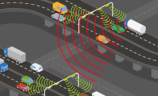
Recent years have seen an increase in drivers turning to cheap GNSS jamming devices in order to move around undetected or to thwart built-in anti-theft systems or road tolling systems. These jammers not only knock out their own GNSS receiver, they also block GNSS signal reception in a radius of several hundred of meters.There is a growing demand for automatic detection of these illegal jammers to help catching the offending driver.
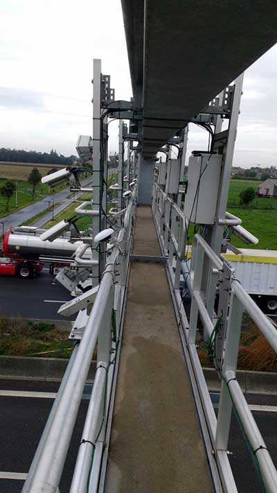
Septentrio GNSS antenna placement on highway gantry. (Photo: Septentrio)
An ION GNSS+ 2018 presentation by Wim de Wilde and Jean-Marie Sleewaegen presentation showed how a multi-antenna GNSS receiver with built-in RF spectrum monitor and adequate processing tool can efficiently detect and classify jamming events and identify the offending car or truck. They conducted a five-day test with two Septentrio AsteRx-U dual-antenna receivers installed on an overhead structure above a busy highway.
In parallel to the GNSS tracking and built-in anti-jam functionality, the AsteRx-U can simultaneously sample the RF signal from its two antennas. One of the objectives of the test was to evaluate the possibility to perform lane detection by cross-correlating the jamming signal received by the two antennas. In addition, the antennas were mounted with a significant inclination angle to create an asymmetrical reception pattern.
The goal was to assess the feasibility of detecting the driving direction from the time series of the received jammer power. Such lane or direction detection would greatly help identifying the offending driver in heavy traffic conditions when more than one vehicle crosses the overhead structure at the time of the jamming.
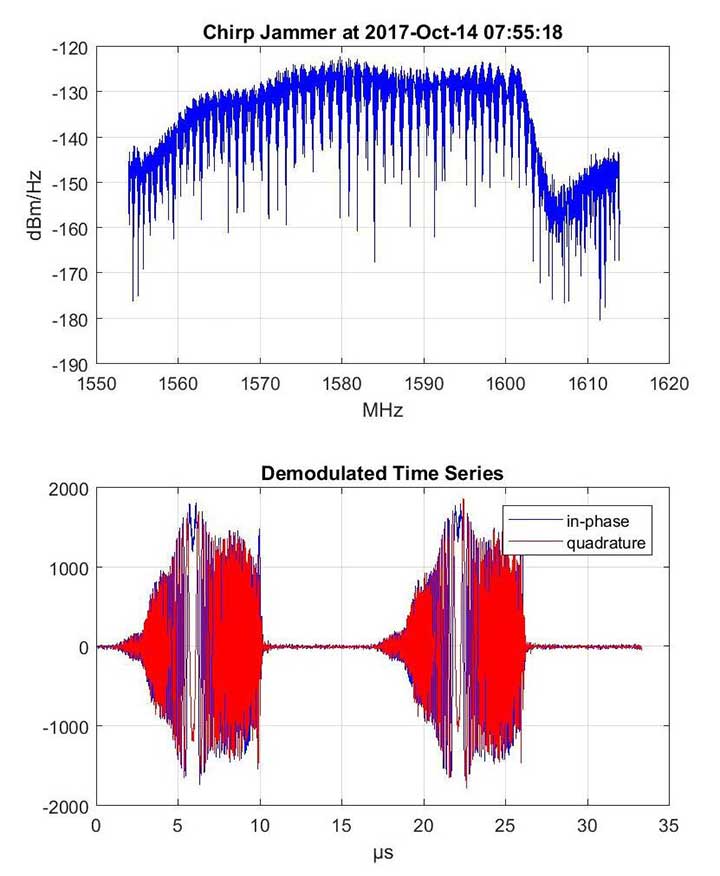
Over the five days of the experiment, 45 jamming events were recorded and analyzed, most of them intentional: continuous wave, chirp or even less-known pulse jammers.
Chirp jammer example. (Charts: Septentrio)
The researchers explained how the jamming events are automatically detected and classified by the processing tool, using pattern recognition to distinguish between intentional harmful events and unintentional interferences. They presented selected cases illustrating the RF signature of the most prevailing types of jammer.
They then addressed the direction and lane sensing algorithm and discussed the effect of multipath propagation of the jammer signal. All algorithms are illustrated with real-life examples.