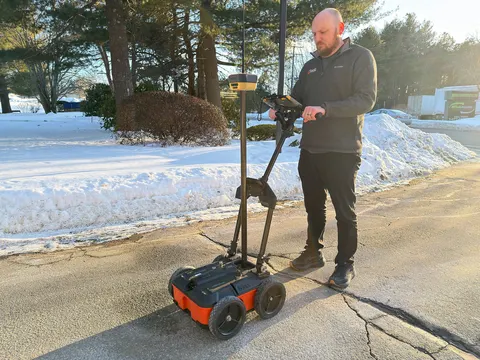
Topcon Positioning Systems and Geophysical Survey Systems, Inc. (GSSI) are collaborating to pair GSSI’s advanced ground penetrating radar systems with Topcon’s GNSS solutions and mass data workflow software. The new integrated solution will support applications across infrastructure and construction projects.
“GSSI is a long-standing industry leader in ground penetrating radar (GPR) systems, and we are excited to work with them on providing industry professionals with an advanced, integrated solution,” said Ron Oberlander, head of the Topcon Geomatics Platform. “By combining GSSI’s GPR technology with Topcon’s HiPer XR GNSS receiver, Topnet Live correction services, and Collage Web mass-data workflow software, we are bridging subsurface detection and spatial context from field to analysis.”
“Collaborating with Topcon allows us to unify GPR data and GNSS data to deliver visual, decision-ready insights, providing a more complete picture of the world above and below the surface,” said Chris Green, chief executive officer of GSSI. “Together, GSSI and Topcon are helping customers plan smarter, validate faster, and deliver higher quality outcomes with fewer surprises.”
The new solution will be showcased in both the Topcon Positioning Systems booth and the GSSI booth at CONEXPO-CON/AGG, taking place March 3-7 in Las Vegas.
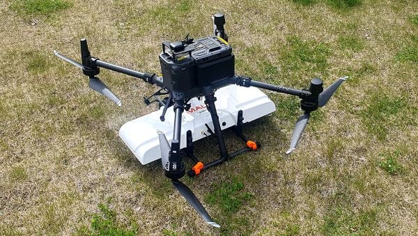
SPH Engineering is offering two new ground-penetrating radar systems optimized for UAV integration: MALÅ GeoDrone 600 and Zond Aero 600 NG.
Both 600 MHz antennas significantly enhance high-resolution subsurface investigations with drones, supporting applications in engineering surveys, utility mapping, archaeology, environmental studies and geophysical research. They enable surveyors to capture consistent, high-quality subsurface data in areas difficult, slow, or unsafe to access with traditional ground instruments.
Operating at 600 MHz, the antennas offer a balance between penetration depth and fine near-surface resolution. Typical penetration from the drone is up to 2 meters, depending on the surface conditions, while SPH Engineering’s True Terrain Following ensures stable antenna height to maintain data quality and repeatability.
Compared to ground-based carts or vehicle systems, the UAV-borne configuration enables operators to:
Survey rocky, uneven, vegetated, or steep terrain
Achieve consistent grid spacing and uniform antenna coupling
Cover large areas significantly faster than manual GPR methods
Improve safety by reducing personnel exposure in risky field conditions
The MALÅ GeoDrone 600 combines the reliability of MALÅ instrumentation with SPH Engineering’s fully integrated drone workflow. Designed for precision engineering, utility detection, and geophysical mapping, the antenna produces clear, high-quality radargrams suitable for detailed structural assessment and shallow subsurface characterization.
Key Specifications
Central frequency: 600 MHz
Operating Bandwidth: 250-900 MHz
Typical penetration: up to 2 m (soil-dependent)
Sampling: MALÅ HDR technology
Antenna design: Shielded
Weight: 2.7 kg
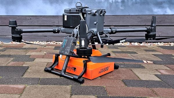
The Zond Aero 600 NG antenna package. (Photo: SPH Engineering)
The Zond Aero 600 NG is a next-generation shielded antenna designed specifically for airborne GPR operations. It offers a strong signal-to-noise ratio, improved ground coupling at low altitudes, and robust performance over natural terrain, making it particularly suitable for geophysical research, archaeology and environmental geoscience.
Key Specifications
Central frequency: 600 MHz
Operating Bandwidth: 300-950 MHz (-12 dB)
Typical penetration: up to 2 m (soil-dependent)
Sampling: Real-Time Sampling (RTS) with high hardware stacking
Antenna type: Shielded
Weight: 1.7 kg
Both antennas are fully compatible with SPH Engineering’s UgCS flight planning software and the SkyHub drone onboard computer, enabling:
Automated terrain-following flights over complex topography
Precise altitude control for optimal GPR signal geometry
Synchronized GNSS + radar trace logging (for Zond Aero 600, MALÅ GeoDrone 600 has built-in data recorder).
A team deployed ground-penetrating radar mounted on drones, showing that the technology can search and locate targets buried deep in glacial ice.
On July 15, 1942, six P-38 Lightning fighter aircraft and two B-17 Flying Fortress bombers encountered a blizzard while supporting the Allied war effort in the British Isles.
The aircraft were forced to conduct an emergency landing on the glaciers of Greenland, and though all the crew members were rescued nine days later, the aircraft were left behind.
After using radar to find areas of interest in 2011, an expedition led by the non-profit Arctic Hot Point Solutions returned to Greenland.
Ground-penetrating radar was integrated with a drone for the survey mission in Greenland. (Photo: Arctic Hotpoint Solutions)
This time, the team deployed ground-penetrating radar mounted on drones, and showed that the technology can search and locate targets buried deep in glacial ice. Aerial surveying was more effective and less risky than working on the ice.
The team extracted hydraulic fluid from 340 feet below the surface, leading to the identification of the buried aircraft as the P-38 Echo piloted by Robert Wilson.
Six undiscovered aircraft — also part of the “Lost Squadron” — remain entombed in shifting glaciers, along with many additional WWII aircraft that went down over of Greenland as they flew between the United States and the European theater.
A future expedition will attempt to excavate Echo, and locate other aircraft of the Lost Squadron.