The Empire State Building sits atop a massive and solid foundation that hardly anyone ever sees. Above ground it has 2.8 million square feet of offices and hundreds of businesses. It houses 15,000 workers. Yet it would all come crashing down if the underlying and unseen foundation weren’t incredibly strong and dependable.
Timing is the unseen foundation of every networked technology, digital broadcast, financial transaction, electrical grid management and of most navigation systems, just to name a few applications. Yet, as GPS World readers know, signals from our dominant source of timing — GPS — are very faint and easily disrupted.
Short term, localized disruptions happen all the time, and many systems have adapted. A delivery driver using a jammer to hide from his boss is unlikely to disrupt a cell base station as he passes by, for example.
Photo: Georgijevic/E+/Getty Images
But more serious threats are out there. More and more hobbyists are finding ways to spoof receivers. Every few decades the sun flares strongly enough to fry satellites or charge the ionosphere. And because there are so few alternatives, GPS and other GNSS have become huge, tempting targets for adversary nations, terrorists, and sophisticated hackers.
Instead of Manhattan bedrock, our timing foundation is sometimes more like shifting sands.
Systems engineering tells us that, if something is essential, there ought to be two, three or more independent ways of receiving it. Most aircraft, for example, have two or three systems powering the flight controls — because controlled flight is important!
The white paper “A Resilient National Timing Architecture” outlines how the United States can leverage existing infrastructure and provide all citizens two, and many of them three, independent paths to coordinated universal time (UTC).
It proposes a national timing back- bone of mature technologies with very different failure modes — GNSS, eLoran and fiber. This combination will provide rock-solid timing at the 500 ns or better level of accuracy relative to UTC everywhere across the nation, and at 100 ns or better in major metro areas. Users accessing two or more systems would be nearly bulletproof to timing service disruptions.
The National Timing Resilience and Security Act of 2018 mandated a terrestrial system to back up GPS timing. Our white paper provides a path forward.
Complying with the law while benefiting current and future technologies should be sufficient motivation. If it isn’t, we must also realize that not acting on this will continue to place us behind other nations such as the United Kingdom, South Korea, Russia and China — all of whom are actively reinforcing their national timing systems.
The task will not be a simple one. Yet America was able to overcome the expense and difficulties of building GPS, at the time the world’s most refined and complex technology, and put it in space. By comparison, establishing a resilient national timing architecture using existing technology in our homeland would be child’s play.
Timing is essential. It is infrastructure for our infrastructure. If our national timing is weak, so is everything that is built upon it.
We will profit from ensuring our timing is as strong, resilient, and easily accessed as possible.
Coalition gives voice to PNT companies seeking open-market approach to backing up GPS/GNSS for critical infrastructure
Several GNSS and positioning, navigation and timing (PNT) companies have joined forces to create a new lobbying group, the Open PNT Industry Alliance. Founding companies include InfiniDome, Iridium Communications, Jackson Labs Technologies, NAVSYS Corporation, NextNav, OPNT, Orolia, Qulsar, Satelles and Seven Solutions.
In the United States, the coalition believes the Executive Order on “Strengthening National Resilience Through Responsible Use of Positioning, Navigation, and Timing Services,” issued in February 2020 begins the process for a national alternative PNT policy.
The report was criticized by some lawmakers for inaccuracies and lack of depth, but several companies whose solutions were referenced in the report defended it, and have now joined in creating this new alliance.
The alliance expects to support similar initiatives in other countries.
The coalition is designed to fortify economic and national security by supporting government efforts to accelerate the implementation of backup PNT capabilities for critical infrastructure. Other companies sharing these views are invited to join the alliance.
The Open PNT Industry Alliance will be introduced in an Orolia PNT Coffee Talk webinar on Thursday, Dec. 17, at 10 a.m. EST.
A serious problem facing nations around the world is that GPS and other GNSS are susceptible to inadvertent disruptions and deliberate attacks. Such incidents have the potential to impair or incapacitate communications networks, transportation systems, energy production and distribution platforms, financial services operations and other types of critical infrastructure.
With the scope, complexity and severity of disruptions and attacks evolving continuously, the combination of wide-ranging PNT solutions and emerging technologies offers superior protection to current threats by providing a backup to GPS/GNSS and improving national resilience.
“Multiple forms of alternative PNT deliver the broadest possible range of operational and performance characteristics to meet the diverse needs of applications across all industry sectors, plus they can better adapt to future threats than a single technology with its inherent vulnerabilities,” said Michael O’Connor, CEO of Satelles. “The mission of the Open PNT Industry Alliance is to promote open-market concepts that preserve industry’s long-term ability to harness its inventive talent to protect GPS/GNSS with multiple solutions that are technologically advanced, commercially viable, and based on a sustainable long-term funding framework.”
The Open PNT Industry Alliance will share its expertise with governments to aid their efforts to set policies, define regulations, and enact laws that achieve their national resilience objectives while preserving competition in the open market. A principal purpose of the coalition is to stimulate and capitalize on the collective intellect of industry in a collaboration between the public sector and private sector.
“The ingenuity of the private sector is spurred by competition and public and private investment, and this will drive the emergence of multiple GPS/GNSS alternatives that are cost-effective and evolve according to threat profiles, technological innovations, and market dynamics,” said Jean-Yves Courtois, CEO of Orolia. “Similarly, unbridled innovation will address new and still evolving use cases not supported by GPS/GNSS.”
The coalition will work closely with governments as they consider plans for regulation of critical infrastructure sectors and funding for alternative PNT. Legislators and policymakers can best pursue national interest through a multi-technology approach to PNT resilience, the coalition stated in a press release. The coalition will advocate for the establishment of a robust and self-sustaining funding framework that allows for the development and adoption of multiple sources of PNT that meet the needs of various sectors and industries.
“We believe a multi-technology approach to PNT resilience not only meets a more diverse set of critical infrastructure needs but also ensures a more robust approach to security by providing multi-layer resilience,” said Ganesh Pattabiraman, CEO of NextNav. “Delivering alternative PNT capabilities on an equal footing with GPS will require government policies and funding that ensure these solutions are cost-effective for critical infrastructure providers and sustainable over the long term.”
The U.S. Department of Homeland Security (DHS) issued a report on alternative sources of PNT on May 6. It was submitted to U.S. congressional committee leaders on April 8.
Section 1618 of the 2017 National Defense Authorization Act (NDAA) of Dec. 23, 2016, required the DHS to address the need for a GPS backup by identifying and assessing viable alternate technologies and systems.
The report is a summary and analysis of that assessment by the Homeland Security Operational Analysis Center (HSOAC) of PNT systems currently used by critical infrastructure. It also provides recommendations for the federal government’s next steps to increase the resilience of critical infrastructure to disruption of GPS services.
In the report, DHS offers the following recommendations to address the nation’s PNT requirements and backup or complementary capability gaps:
Temporary GPS disruptions: End users should be responsible for mitigating temporary GPS disruptions. For example, the Federal Aviation Administration maintains sufficient PNT capabilities to assure the continued safe operation of the national airspace, albeit at a reduced capacity, during GPS disruptions. The federal government can facilitate this mitigation for various critical infrastructure sectors, but should not be solely responsible for it.
PNT Diversity and Segmentation: The federal government should encourage adoption of multiple PNT sources, thus expanding the availability of PNT services based on market drivers. Encouraging critical infrastructure owners and operators to adopt multiple PNT systems will diffuse the risk currently concentrated in wide-area PNT services such as GPS. Federal actions should focus on facilitating the availability and adoption of PNT sources in the open market.
System Design: PNT provisioning systems, assets, and services must be designed with inherent security and resilience features. Critical infrastructure systems that use PNT services must be designed to operate through interference and to identify and respond to anomalous PNT inputs. These attributes are applicable to the PNT receivers and the systems that use them.
Pursue Innovation that Emphasizes Transition and Adoption: Incorporating PNT signal diversity into the PNT ecosystem should be pursued with an emphasis on research and development that prioritizes successful transition and adoption into existing GPS receivers, taking into account factors such as business case considerations, financial costs, technical integration, and logistical deployment.
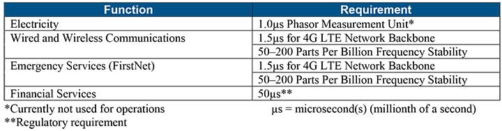
Table 1 shows timing requirements for critical infrastructure are, according to the report.
Table 1. (Image: DHS report)
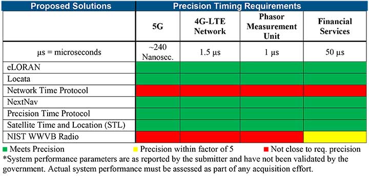
Table 2 from the report shows proposed timing solutions submitted by industry to DHS during a Request for Information (RFI) in December 2018. Systems that can meet or exceed timing requirements for critical infrastructure are indicated in green.
Table 2 (Image: DHS report)
Satelles responds
The Satelles company, which offers STL, issued a statement on the report. “This important report highlights the urgent need for GPS backup for critical applications, and it identifies and characterizes a variety of solutions that are available to meet this need today,” said Michael O’Connor, CEO of Satelles. “The report also describes the essential role of the federal government in urging industry to implement multiple technologies, without making the mistake of providing or selecting a single PNT solution.”
Continued O’Connor, “DHS goes on to define a baseline requirement for timing services accuracy for critical infrastructure. Not only does Satelles meet or exceed the precision timing specifications stated by DHS, but also our solution provides national coverage (including Alaska, Hawaii, and U.S. territories) and is commercially available now.”
Which of several proposed terrestrial PNT technologies is best suited to complement and back up GPS?
Jules McNeff
“Seeking PNT resiliency for critical functions, a layered, multi-source terrestrial RF backup strategy could include eLoran for continental coverage and Locata, or similar system(s), for high-precision, localized service where needed. However, don’t forget feature-aided navigation using optical, radar, lidar, etc., and positioning/timing from ‘validated’ signals of opportunity in data-rich environments.” Jules McNeff
Overlook Systems Technologies
Terry Moore
“No single technology can provide a backup to GNSS to match the ubiquity of satellite-based PNT. However, placing inertial navigation systems at the core of our PNT solution, and focusing on bounding the growth of the positioning errors using whatever other space or terrestrial measurements are available, could provide an alternative paradigm to resilient positioning and navigation.” Terry Moore
University of Nottingham
Members of the EAB
Tony Agresta Nearmap
Miguel Amor Hexagon Positioning Intelligence
Thibault Bonnevie SBG Systems
Alison Brown NAVSYS Corporation
Ismael Colomina GeoNumerics
Clem Driscoll C.J. Driscoll & Associates
John Fischer Orolia
Ellen Hall Spirent Federal Systems
Jules McNeff Overlook Systems Technologies, Inc.
Terry Moore University of Nottingham
Bradford W. Parkinson Stanford Center for Position, Navigation and Time
The U.S. Department of Transportation is preparing for a GPS backup and complementary positioning, navigation and timing demonstration for the Department of Defense at the Joint Base Cape Cod, Massachusetts.
Demonstration for testing is expected to begin in the spring of 2020, and DOT is seeking contractors to make Building #2410 at the base functional so that the demonstrations can be held there.
Diana Furchtgott-Roth, deputy assistant secretary of Transportation for Research and Technology, is leading the project. Working through the Volpe National Transportation Systems Center, Furchtgott-Roth’s goal is to demonstrate as many of the technologies as possible and conclude the effort by March of next year.
The last two U.S. presidential administrations failed to follow through on promises to protect GPS and the nation with a system to backup GPS. A recent Department of Transportation (DOT) appointee is aiming to fix that.
Diana Furchtgott-Roth is deputy assistant secretary of Transportation for Research and Technology. Her office has a broad range of responsibilities including as the federal government lead for civil GPS and PNT issues.
Since Furchtgott-Roth arrived at the department in February, she has been adamant about the need to establish a complementary and backup system that users can access when GPS is not available or signals need reinforcing. She notes that this has been a presidential policy requirement for DOT since 2004.
There are also two Congressional mandates on this issue. The first mandate was in a law passed in 2017. The National Defense Authorization Act tasked the Departments of Defense, Transportation, and Homeland Security to jointly conduct a technology demonstration of GPS backup technology.
Congress funded this project in 2018 through the Defense department, even though DOT was the lead agency. Bureaucratic delays in transferring the funds between departments has meant that, rather than concluding in the summer of 2019 as initially required, the demo is behind schedule by about eight months.
Much of this transpired before Furchtgott-Roth arrived on scene and she is determined to make up for lost time.
A Request for Information (RFI) seeking candidate GPS backup technologies was issued in early May of this year and closed 30 days later. Twenty-two responses were received, though some just offered comments and observations rather than proposing technologies.
Working through the Volpe National Transportation Systems Center, Furchtgott-Roth’s goal is to demonstrate as many of the technologies as possible and conclude the effort by March of next year.
“We want to thoroughly understand all of the proposed technologies, including their ability to penetrate indoors and underground without assistance,” Furchtgott-Roth said.
The department’s procurement website forecasts a Request for Proposals for this effort this month (the site says it will be issued in the fourth quarter of the fiscal year which ends on Sept. 30). The opportunity is described as “Backup Global Positioning System (GPS) Technical Consulting Services for participation in a technology demonstration” with an estimated value of between $700,000 and $2,000,000.
Small businesses that want to be on the notification list for this can do so through the FedBizOpps announcement page.
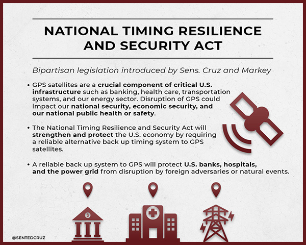
The second legislative mandate was signed into law in December 2018. The National Timing Resilience and Security Act requires the Department of Transportation to establish a timing system to back up GPS by December 2020.
Among the requirements specified in the Act are that the system must be terrestrial, wireless, have wide area coverage, be difficult to disrupt, and be capable of expansion to provide positioning and navigation services.
Furchtgott-Roth plans to integrate the department’s responses to both taskings as much as possible. “What we learn from the tech demo should very much inform the implementation of the National Timing Resilience and Security Act,” she said.
She also wants everyone on the project to keep in mind that establishment of the timing system is just the first phase of creating a more robust and resilient national PNT architecture. “Timing is important, and we are going to reinforce it first,” she said. “But it is not going to provide resilient positioning and navigation for drones, autonomous vehicles, and all our other transportation needs. America must have a combination of systems available that, when used together, will be very difficult to disrupt.”
To keep things moving quickly, Furchtgott-Roth says she is leaning toward signals provided by a commercial entity, rather than a government-built system.
“The Act suggests we consider a public-private-partnership, and there are a lot of advantages to that,” she said. “The government wouldn’t need to stand up a big acquisition staff or have a large appropriation of funds from Congress. Also, private entities are often able to act faster and be more agile. And they assume most of the project risk.” The aviation safety ADS-B system was created using such a procurement model.
The only snag is that while Congress has appropriated money for the tech demo, it has not yet done so for the mandated operational system. Sources in Congress point out that although the House version of the 2020 budget has $32 million for Air Force “Resilient PNT,” nothing has been allocated for civilian users.
“$32 million would go a long way for DOT’s efforts to protect the 99.9% of GPS users who are not in DoD,” said one congressional staff member. He was hopeful the Senate would designate funds in its version of appropriations for DOT and the issue would be resolved positively in conference.
“GPS has become an invisible utility that so many of our technologies depend upon,” observed Karen Van Dyke, who leads PNT efforts for Furchtgott-Roth’s office. “Providing a complementary and/or backup capability ensures users have PNT even when GPS is disrupted. It may also help protect the signals themselves by deterring malicious actors who might otherwise want to jam or spoof GPS.”
“President Trump’s top priorities are national and economic security. We can’t have GPS signals be a single point of failure for transportation and other critical infrastructure sectors,” Furchtgott-Roth said.
Dana A. Goward is the president of the Resilient Navigation and Timing Foundation.
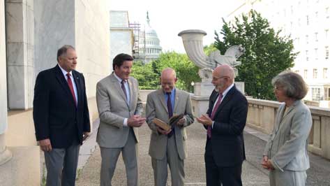
RNT Foundation Directors and Congressmen. From left: RADM Jeff Hathaway, USCG (ret); Rep. John Garamendi (D-CA); Rep. Peter DeFazio (D-OR); Dana A. Goward, SES, CAPT, USCG (ret); and CAPT Pauline Cook, USCG (ret). (Photo: Resilient PNT Foundation)
“It’s absolutely vital for national security that we get a terrestrial based, hard backup system [for GPS],” said Congressman Peter DeFazio (D-OR), chairman of the House Transportation and Infrastructure Committee.
His remarks came at an event organized by the RNT Foundation to recognize DeFazio and Congressman John Garamendi (D-CA) for their support of the National Timing Resilience and Security Act of 2018. Representative Garamendi is chairman of the House Armed Services Readiness subcommittee.
Garamendi first introduced legislation in 2016 to address the nation’s need for a GPS backup system. After going through several iterations, it was signed into law in December. The Act requires the Department of Transportation to establish a terrestrial timing system by 2020. Also, that the new system be expandable to one that can be used for location and navigation.
Congress funded a GPS Backup Technology Demonstration through a Department of Defense appropriation in early 2018. The demonstration was intended to be a joint project of the Departments of Defense, Homeland Security and Transportation. A delay in transferring funds from Defense to the other two departments put the demonstration almost a year behind schedule. Now that the project is underway, Transportation Department representatives have said they want to transition directly from the demonstration to deciding upon and implementing the mandated timing system.
At the event, DeFazio remarked that as a boater and hiker he is an avid user of GPS. He mentioned that it is an “ incredible utility, but I also know of its vulnerability. It’s critical to national security and the meaningful movement of everything in the United States of America from airplanes to surface transportation and others … It’s absolutely vital for national security that we get a terrestrial based, hard backup system.” He also noted that Congressman Garamendi has been the driving force for this issue in the House of Representatives.
Speaking about his current role on the Armed Services committee, Garamendi said “The reality is that the military is not prepared for the loss of the GPS signal, and they are just now becoming aware after seven years of beating them over the head saying ‘guys, what are you going to do when you don’t have GPS?’” Garamendi noted that the military would be a big users of the domestic backup system.
He also regretted that after “… years of people saying ‘single point of failure’ for the American economy and system is the loss of GPS” the nation is not farther along to having a backup system.
The RNT Foundation presented the congressmen with plaques showing images of a GPS satellite and a terrestrial transmission tower, and 0ne of America’s “first GPS devices” — a 102-year-old copy of The American Practical Navigator by Nathaniel Bowditch.
The meeting will be open to the public up to the seating capacity of the room. Visitors will be requested to sign a visitor’s register.
The agenda for the meeting includes the following topics:
Examine methods to protect, toughen and augment (PTA) access to GPS/GNSS services in key domains for multiple user sectors.
Examine emerging trends and requirements for PNT services in U.S. and international fora through PNT Advisory Board technical assessments, including backup services for terrestrial, maritime, aviation and space users.
Update on U.S. Space-Based PNT Policy and GPS modernization.
Explore opportunities for enhancing the interoperability of GPS with other emerging international GNSS.
Prioritize current and planned GPS capabilities and services while assessing future PNT architecture alternatives with a focus on affordability.
Assess economic impacts of GPS/GNSS on the United States and in select international regions, with a consideration towards effects of potential PNT service disruptions if radio spectrum interference is introduced.
Review the potential benefits, perceived vulnerabilities, and any proposed regulatory constraints to accessing foreign Radio Navigation Satellite Service (RNSS) signals in the United States and subsequent impacts on multi-GNSS receiver markets.
Meeting times are 8:30 a.m. to 5:30 p.m. Eastern Time on Thursday, June 6; and 9 a.m. to 1 p.m. ET on Friday, June 7.
Meeting address:
Westin Hotel Alexandria Old Town
400 Courthouse Square
Alexandria, VA 22314
Full details on the meeting can be found in the Federal Register Notice. For more information, contact James J. Miller, designated federal officer, Human Exploration and Operations Mission Directorate, NASA Headquarters, Washington, DC 20546, (202) 358-4417, fax (202) 358-4297, or [email protected].
Most observers missed the $5 million for a GPS backup technology demonstration in the U.S. Department of Defense appropriation passed in September. Congressional staff say it is included in an obscure research and development line item for “Electronics and Electronic Devices.”
This funding is in addition to the $10 million Congress provided for the project last fiscal year (note: since these are R&D funds, the monies remain available for three years after they are appropriated).
This additional funding is part of Congress’ long but accelerating march to establishing a terrestrial PNT system to backup and complement GPS, an effort with which the administration is struggling to keep pace.
Image: @SENTEDCRUZ
Members in both the Senate and House were surprised and concerned in 2009 when the Obama administration suddenly went against the advice of its departments, national advisory board, and virtually every technologist and engineer in government. That is when the administration decided to terminate plans to convert the old Loran-C system to eLoran as a complement and backup for GPS.
Congress’ concern was not completely allayed when, in a report Congress had mandated, the administration said that a wireless GPS navigation backup was not needed. Users could easily resort to paper maps and charts. The same report did admit that the need for wireless precise timing was another issue. The administration said it would study this, even as the Loran-C system was being terminated.
Subsequent hearings in Congress revealed ongoing concerns about the lack of a terrestrial capability. These were magnified by the nation’s major adversaries, Russia and China, retaining terrestrial Loran systems to inoculate themselves from the effects of disruptions to their space-based PNT systems.
More mixed signals from administration officials amplified Congress’ concerns and frustrations. These included:
The Department of Defense committing to establishing a terrestrial backup for GPS within the United States, then reversing its position just before its authorization bill was finalized. This reversal was not based upon technical or national security grounds; rather, that it “wasn’t the department’s job.” This reversal nullified almost two years of coordination and effort by Congressional members and staff.
A senior Department of Defense official at a hearing providing grossly inaccurate information about GPS resilience and backup systems. The official subsequently retired.
The Deputy Secretaries of Defense and Transportation in 2015 promising action to the chairman of the House Transportation Committee. In a December letter they said the administration would establish a GPS backup by first establishing an eLoran timing system, and then an eLoran navigation system. Aside from signing the letter, no further action was taken.
Congress’ growing skepticism about administration positions on this has led to a series of hearings, informal inquiries, demands for reports, and legislation. Together they chart a very deliberate effort to bypass bureaucratic infighting and confusion as much as possible en route protecting the nation with a terrestrial complement and backup for GPS.
Legislative action has included :
in 2015, halting demolition of Loran-C infrastructure pending a decision on a GPS backup system. (USCG Authorization Act)
in 2016, requiring the departments of Defense, Homeland Security and Transportation to identify requirements for a domestic GPS backup and report before the end of 2017. (National Defense Authorization Act/ NDAA)
in 2017, requiring a plan for a GPS backup technology demonstration by April 2018, completion of the project by June 2019, and authorizing $10 million for the program. (NDAA)
in March 2018, providing $10 million for the GPS backup technology demonstration (DoD Appropriations)
in August 2018, reaffirming Congress’ interest in the backup demonstration, requiring a progress brief by Dec. 1 2018, and authorizing another $5 million for the project (NDAA)
In September 2018, funding an additional $5 million for the backup demonstration (DoD Appropriations)
In December 2018, the National Timing Resilience and Security Act of 2018 was signed into law. It directs the Secretary of Transportation to establish a terrestrial, difficult-to-disrupt, wireless timing system to provide backup capability for GPS. A report on requirements and an implementation plan are due in June 2019, and system operation is mandated by December 2020.
Contacts with members and staff in the new, 116th Congress show that interest in this topic has increased. So has frustration with the administration missing many, if not most, of its deadlines for reports and briefings.
A recent GAO report that U.S. weapons systems are vulnerable to GPS spoofing; the need for a strong navigation and timing infrastructure for autonomous vehicles, drones, and intelligent transportation systems; and continued high visibility instances of deliberate GPS jamming and spoofing are all adding to concerns.
Also of note, Congressman Peter DeFazio (D-OR) has been named chairman of the powerful House Transportation and Infrastructure Committee. Rep. DeFazio has long believed in the need for action to provide a backup capability for GPS.
Congress is clearly set on a determined course. Perhaps the administration will catch up before it earns more of the Congress’ ire, and before a major disruption demonstrates the consequences of inattention to the entire nation and the world.
The day started like any other day. The land surveying crew loaded up their vehicle, equipment and marching orders to tackle the next project on the list.
This field party is like most surveyors across the globe — they are equipped with the latest surveying technology including GPS base and receivers, robotic total station and a UAS for aerial photography. These tools are necessary to be competitive in today’s surveying arena as speed and productivity are paramount to the success of the project and the company.
But on this day, any device with the ability to determine geographic location via satellite reception was rendered useless.
Today became known as the day that GPS went away.
How we became dependent on GPS
Let’s back up the story to the introduction of GPS and how our dependency on this technology came to be. With the invention of satellites culminating with the Russian effort to launch Sputnik, the United States became involved in a “race to space.” Our early efforts to use satellites were proven worthy with the successful ability to track submarines by reception of radio signals and trilateration.
Further enhancements through research resulted in the development and creation of the NAVSTAR satellite in 1978. By 1993, 24 satellites were in orbit to make the GPS system fully functional (NASA.gov).
Meanwhile, the Russians were committed to a satellite network for navigational purposes during the same time period. The first satellite, Kosmos-1413, was launched in 1982 with the full 24 satellite constellation becoming operational in 1995.
Together, these systems (known as global network satellite systems or GNSS) allowed for location and navigation abilities never thought possible, and the surveying community began its adoption of the technology.
Early survey adopters of GPS were usually large engineering firms, state departments of transportation (DOTs) and federal agencies that could afford the large financial commitment to the equipment (both GPS and computers), software and computing costs required to use the technology.
The data-collection times were long, and the software analysis required enormous patience and extensive mathematical knowledge, but the results were beyond what the everyday surveyor had ever before accomplished.
Significant distances could now be measured with the same or better accuracy than taping or using an electronic distance meter could have provided. The true revolution came when real-time kinematic (RTK) GPS was invented and was affordable to the everyday surveyor (GPS World, May 2016).
S/A and A-S
Most GPS users, especially operators of survey-grade receivers, are not aware of the early days of satellite navigation and the military’s use of selective availability, otherwise known as S/A (GPS World, Sept/Oct 1990). This methodology was implemented by the Department of Defense (DoD) on May 25, 1990 to limit accuracies for non-military GPS users.
This procedure was created to allow erroneous timing at random occurrences throughout transmission of satellite radio signals. These variations in timing more than negatively tripled the normal precision of an autonomous GPS position calculation, all in the name of introducing uncertainty to potential enemy users.
And if S/A wasn’t enough, the DoD also could implement another deterrent called anti-spoofing (A-S) and encrypt the precision or P-code of the satellite signal. The big factor here is that the general public (in our case, the surveying community) didn’t know if or when A-S was turned on. These factors were frustrating to the GPS user, so data collection and coordinate determination became a tedious operation.
Early receiver use by surveyors relied on differential GPS data collection for high-accuracy location (<10 cm or better). This method consisted of placing one or more receivers on known positional points (usually on monuments published through the National Geodetic Survey) while simultaneously performing data collection on new points for positional establishment.
Prior to S/A, the software utilized to analyze and reduce the data collection provided feedback on “bad” data, but there were usually environmental issues causing the problem (such as cycle slips and radio interference.) The software would highlight the suspect data for the reviewer to determine validity and acceptance.
Because of the nature of differential GPS data collection, error checking remained the same once S/A was implemented. If the software calculated an incorrect coordinate at a known point, the same measurements to the new survey point were dismissed as a false reading.
Surveyors were mostly left unfazed by S/A as real-time kinematic (RTK) and real-time network (RTN) follow a similar procedure utilizing a correction from a known terrestrial point. Even with the anti-spoofing activated, the surveying profession continued to use this high-tech location system that revolutionized long distance measurement. Things have been running along smoothly with steady improvement of receivers, data collectors, and data coverage until…
The day it goes away
…the unthinkable happens. Our national satellite system is no longer available.
It doesn’t matter why GPS has gone away on this day. It could be for many different reasons: federal budgets; enemy interference such as geomagnetic disturbances (GMD) or electromagnetic pulse (EMP);
conventional or nuclear war; interference from solar storms, asteroids, or comets; or the system just simply breaks.
Artist’s rendering of a cross-section of the Earth’s magnetosphere. (IMAGE: NASA)
Another thing for all users of GNSS to consider in these tumultuous times is how newer systems are integrating other countries’ satellite networks into their navigational observations.
Our relationship with the Russian government can be on unsteady ground from time to time, so our use of their GLONASS signals must be reviewed for accuracy as well (See GPS World, August 2017).
It won’t matter whether a spoofed satellite signal originates from a private Russian hacker or from their actual government; it will still lead to incorrect information and bad data. Imagine having to revise a plat because the GLONASS data was purposely corrupted!
Obviously, the main reason they would allow transmittal of misinformation would be for military reasons, but I can only imagine their joy of messing with professional navigation and the recreational users in the U.S. These opportunities will also apply to the Chinese and Indian constellations, too.
We’re not ready
The bottom line is that we, the U.S., aren’t ready for it. Whatever may be the reason for the failure, we do not have a backup plan and have relied much too heavily on satellite navigation. Gone is our ability to navigate through our electronic devices, including smartphones, fitness trackers, in-car mapping and, yes, high-precision surveying equipment. These items have now become door stops and space wasters.
This new conundrum doesn’t just stop with the surveyor and recreational GPS equipment. A significant amount of construction equipment relies on machine control, from bulldozers and road graders to high-rise cranes.
This will also affect a large amount of agricultural equipment and processes. Those high-tech tractors with autosteer and computer-guided planters? Back to the drawing boards. So many things in our lives today are guided or controlled by navigational systems designed around GPS use, and the surveyor is squarely in this mix.
What’s a surveyor to do?
The first thought on the surveyor’s mind is now having to perform all surveying tasks with instruments that are not based on satellite navigation. Yes, the reason for this GPS shutdown isn’t widespread enough to affect cellphone signals and other radio communications, but it killed off the one navigation system more people rely on than any other.
Because of this unfortunate shutdown, all GPS-based equipment is now worthless. This means your trusty RTN receiver with cellphone connection, your old base unit for those times when cellphone coverage is lacking, the fancy new UAV for taking orthophotography, and your cellphone or handheld GPS receiver for tracking down NGS monuments — all of them are done. Only your conventional equipment will complete the job.
Is the surveying profession finished? How do we locate those remote section corners in the middle of nowhere?
Don’t throw in the towel just yet. Surveyors have been measuring land using these types of instruments for centuries, with today’s versions being electronic and sophisticated. Robotic servos, mini computer-data collectors, efficient radio links and active tracking prisms have turned our forefathers’ simple transit into a sophisticated topographic or construction staking machine.
Data collection is much easier than writing everything in a field book, and have graphical interfaces and remote connection capability to keep you in touch with the office from nearly anywhere. The reality, however, is that the surveyor will now have to use methods and equipment for traversing, data collections and all staking tasks that will greatly reduce our productivity and profitability.
Experience could also end up being a big factor here as well. The average age of the professional land surveyor in the United States is 58 and climbing. This means most of these practitioners have been in the business well before GPS technology, so there is still the potential of surveying without the electronic birds in the sky.
Surveyors can still hang their shingle and practice their craft, but we’ve now lost a big component of our world: geographical location. The key to the success of GPS was the ability to determine geographic location and subsequently convert that information into a data format compatible with one’s local system. From UTM coordinates to State Plane, the world became smaller with this technology.
The surveyor can still determine latitude and longitude using manual surveying methods for specifically observing the sun and Polaris. The mathematics and procedures are complicated, but they still allow for determining a geographical location with high accuracy.
We can also utilize the extensive geodetic monumentation networks established nationwide, all started around the formidable effort by the Coastal and Geodetic Survey. This key federal agency, later to become the National Geodetic Survey, laid the groundwork and set the monuments for the backbone of our national horizontal network system. This system has been augmented over the years by their own programs, as well as state and local authorities, to expand our coverage to all portions of the United States.
By incorporating these monuments into a survey, a relationship to geographical datums is still easily obtained. While these methods of establishing geographical coordinates through use of conventional equipment sounds time consuming, without GPS and other satellite-based navigational aids, it will become much more cumbersome.
So, what do we do next?
Depending on which industry you are in or your necessary level of accuracy, several alternatives are being developed. For those in the shipping industry (including the trucking sector, which numbers more than 15 million vehicles), accuracy may only need to be nominal — for instance, 5 meters, give or take.
Several systems are in development with the biggest priority on enhanced loran (short for “long range navigation”) or eLoran (also see GPS World April 2014 and GPS World Nov 2015). Several bills are currently being reviewed in the U.S. House and Senate for consideration of funding this technology.
These programs are still under development, but DARPA has been tasked with finding another system so our dependence on GPS will not cripple our defense in a time of war.
Abraham Lincoln, the county surveyor — a statue at Lincoln’s New Salem State Historic Site, Illinois.
Another alternative will be private satellite networks. With programs like SpaceX and Blue Origin, vehicles to carry new satellites into orbit are now a viable option. It will be possible for companies to create their own networks for private or commercial use.
With the large number of construction, shipping and automobile sales, the day may come when the navigation system within each of these is proprietary. However, if we are faced with geomagnetic disturbances (GMD) or an electromagnetic pulse (EMP) as mentioned earlier, it won’t matter whose network it is — they will all be rendered useless.
Until another viable option is created, the surveyor will be forced to take a step back in productivity and technology with conventional instruments. While not the most ideal thing, it will force the profession to retrain its entire workforce on procedures and methods that haven’t been regularly utilized for many years.
For some, it will be like throwing away the computer for a typewriter or the remote control for the television set. For others, it will be an opportunity to truly “follow in the footsteps” of past surveyors. They will understand exactly how their predecessors went about “running the lines” and completing a true boundary survey.
I, however, hope we don’t find ourselves in this situation, and that a suitable backup system or even a more advanced replacement for our antiquated GPS is invented soon.
But if the day comes and our GPS goes away, I’m guessing that surveyors not having their favorite locating device will be the least of our society’s worries. It will truly be a day that will live in infamy.
“It’s always been time.” That was the first answer out of the gate, given in Session 3 of the Munich Satellite Navigation Summit last month. Dominic Hayes, Spectrum Management and Policy for Galileo, EGNOS and Copernicus at the European Commission, was prompt off the mark. “GNSS is so good, so easy and so cheap, other means are falling out of use.” Therein lies the peril.
That emotion was seconded by every other speaker on the panel. But of course. Virtually no one in the GNSS community at large, let alone those attending the Munich Summit, thinks otherwise.
Thinking and action do not go hand-in-hand, however. GNSS back-up resembles the weather, in that everybody talks about it, yet … yet … nothing changes. As long ago as 2015, the U.S. Department of Transportation and the Deputy Secretary of Defense made noises about building an alternative system to GPS in case of disruption, and certainly there were hand gestures aplenty prior to that.
Do we have a back-up, presently?
No. The U.S. government is in such a hurry to protect its borders that it gives scant thought to protecting what’s inside: critical infrastructure.
Is it time?
It’s always been time.
Things are more like they are now than they ever have been, what with the cloud and all. We’re storing so much data in the cloud, with more and more of the world’s operations every day keyed to and driven by distributed database processing, in huge data servers around the world. This is according to John Fischer of Spectracom, who is in a position to know. Precise timing at the micro- and nanosecond level plays a huge role in connecting and synchronizing users. But again, he was preaching to the choir.
Guy Buesnel from Spirent Federal reiterated the new threat sprung from Pokémon Go: a community of gamers and enthusiastic coders, generating homespun spoofing mechanisms for fun. They will soon realize, if they haven’t already, that there’s profit to be made there as well.
“We have become too reliant on GNSS today,” stated Buesnel. Most interference warnings are low level, but 3 to 4 percent are serious enough to disrupt receiver operations. And that still means you have to take action in response. He stressed the importance of a balanced systems engineering approach, and invoked Brad Parkinson’s PTA mantra: protect, toughen and augment.
Hayes called for a European Radio Navigation Plan, similar to the U.S. Federal Radio Navigation Plan (FRNP). Later, in response to a follow-up question, he acknowledged that “radio” need not be part of all encompassed systems; the proposed name is a legacy of modeling after the FRNP.
So far, the FRNP itself is nothing but a model, a little architectural construct of what someday might be. But nothing’s been built, that particular someday is no closer, and meanwhile the threats loom larger.
NASA’s Ikhana is being used to test a system that will allow uncrewed aircraft to fly routine operations within the National Airspace System. (Credit: NASA)
NASA plans to install a Locata network (LocataNet) as the core positioning technology for safety-critical unmanned aerial systems (UAS) research at its Langley Research Center in Hampton, Va., according to an announcement by Locata.
NASA Langley is tasked with performing rigorous and repeatable scientific evaluation of new UAS safety and technology concepts under development. The LocataNet will provide high-precision non-GPS-based positioning, navigation and timing (PNT) that is essential for this work. Known for its long history of aeronautics research, NASA Langley is a key center for UAS research and development. In June, one of Langley’s unmanned hexacopters (a drone with six rotors) delivered medical supplies to a clinic, the first such delivery by an unmanned drone.
Locata’s centimeter-accurate positioning will now assist NASA to develop and improve flight-critical technology systems that support air transportation safety, efficiency and performance. Langley’s extensive state-of-the-art facilities will be further enhanced with the installation of the LocataNet.
The NASA LocataNet is scheduled to be installed and commissioned before the end of 2015. Locata will supply the LocataLite Transmitters and Locata receivers required by NASA for the installation. Aviation-quality Locata antennas, developed by Cooper Antennas (UK) and previously used by the U.S. Air Force in its own military LocataNets, will also be installed. Locata engineers will support the physical installation, ongoing training and the future technical support required by NASA Langley for this world-first UAS deployment.
Locata Corporation has invented new terrestrial positioning networks which function as local, ground-based replicas of GPS. These networks can be thought of as “GPS hotspots,” according to the company. Locata has amassed 146 granted patents to date protecting these innovations, with many more patents in the works.
Locata is currently shipping commercial systems to demanding and professional end users such as the USAF, NASA, Leica Geosystems, and many others. Locata enables their integration partners to extend GPS-like positioning coverage to modern industrial, commercial, consumer and government applications in areas where GPS is erratic, jammed or unavailable.
“Locata is proud and delighted to have received an order for NASA’s first LocataNet. Globally significant installations like this prove Locata’s new technology is delivering unprecedented levels of performance to many important new applications,” said Nunzio Gambale, Locata CEO. “As our technology roll-out begins to gain pace, the exceptional value Locata brings to next-gen mobile apps has attracted interest from players all over the world. In fact, our list of relationships is now looking like a roster of the world’s crème-de-la-crème. I honestly can’t think of a better or more prestigious name than NASA to add to our growing partner list.”
“Our team is savoring the opportunity to work alongside NASA engineers and we’re excited that Locata will help advance the safety-critical performance of Unmanned Aerial Systems,” he continued. “Almost all future mobile devices or machines, be they on the road, in the air, on a mine site, in a port, in a warehouse, in your mobile phone, or part of the inevitable Internet of Things — all of them are critically dependent on pervasive, reliable, high-accuracy positioning. Locata is being leveraged into these next-gen systems because it’s clear that satellite-based solutions alone can no longer deliver what’s required. Soon, as we bring miniaturized Locata transmitters and receivers to market, our innovations will enable even greater advances in cutting-edge consumer, commercial, and government applications.”
NASA Testing Program. As part of its UAS research, NASA is testing a system that would make it possible for unmanned aircraft to fly routine operations in United States airspace. Through the agency’s Unmanned Aircraft Systems Integration in the National Airspace System (UAS-NAS) project, NASA, General Atomics Aeronautical Systems, Inc. (GA-ASI) and Honeywell International, Inc., are flying a series of tests which began on June 17 and will run through July at NASA’s Armstrong Flight Research Center in California.
“We are excited to continue our partnership with GA-ASI and Honeywell to collect flight test data that will aid in the development of standards necessary to safely integrate these aircraft into the National Airspace System,” said Laurie Grindle, UAS-NAS project manager at Armstrong.
This is the third series of tests that builds upon the success of similar experiments conducted late last year that demonstrated a proof-of-concept sense-and-avoid system. The tests engage the core air traffic infrastructure and supporting software components through a live and virtual environment to demonstrate how a remotely piloted aircraft interacts with air traffic controllers and other air traffic.
“This is the first time that we are flight testing all of the technology developments from the project at the same time,” Grindle said.
This series of tests is made up of two phases. The first is focused on validation of sensor, trajectory and other simulation models using live data. Some of the tests will be flown with an Ikhana aircraft, based at Armstrong, that has been equipped with an updated sense-and-avoid system, as well as other advanced software from Honeywell.
Other tests will involve an S-3B plane from NASA’s Glenn Research Center in Cleveland, serving as a high-speed piloted surrogate aircraft. Both tests will use other aircraft following scripted flight paths to intrude on the flight path the remotely-piloted craft is flying, prompting it to either issue an alert or maneuver out of the other aircraft’s path. These flights will also conduct the first full test of the traffic alert and collision avoidance system (TCAS II) on a remotely piloted aircraft.
During the June 17 test, which lasted a little more than five hours, the team accomplished 14 encounters using the Ikhana aircraft and a Honeywell-owned Beech C90 King Air acting as the intruder. A second test was flown the following day, with a total of 23 encounters. The project team plans to fly more than 200 encounters throughout the first phase of the test series.
“Our researchers and project engineers will be gathering a substantial amount of data to validate their pilot maneuver guidance and alerting logic that has previously been evaluated in simulations,” said Heather Maliska, Armstrong’s UAS-NAS deputy project manager.
The second phase of the third test series will begin in August and will include a T-34 plane equipped with a proof-of-concept control and non-payload communications system. It will evaluate how well the systems work together so that the aircraft pilots itself, interacts with air traffic controllers and remains well clear of other aircraft while executing its operational mission. The aircraft, which will have an onboard safety pilot, will fly an operationally representative mission in a virtual airspace sector complete with air traffic control and live and virtual traffic.