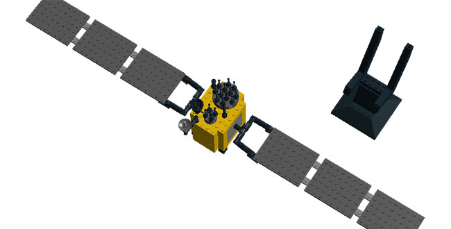
So, you thought GPS satellites were only built by government contractors with millions of dollars? Think again.
A California company that specializes in LEGO kits of space vehicles is offering a GPS IIF satellite kit. The kit, which sells for $45, includes 142 LEGO Bricks, instructions, and a display stand. Once constructed, the model measures 21 1/4-inches from the tip of one solar array to the other, is 2 3/4-inches wide, and 4 1/4 inches tall.
OK, it’s not space worthy. Or the right size. And it doesn’t produce any signals. But the wings rotate!
The company, Space Satellite Models, also offers LEGO models of other Department of Defense and NASA satellites.
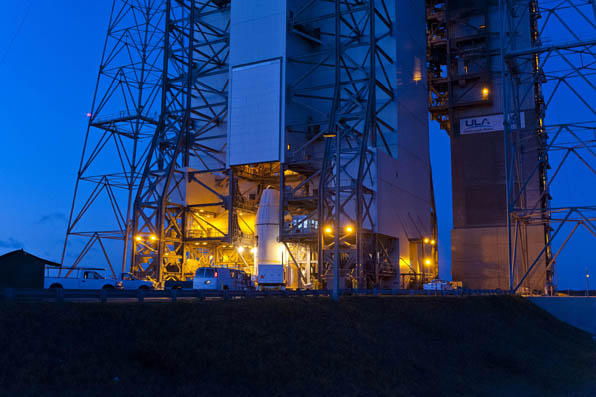
Lift-off is set for 8:10 a.m. EDT (1210 GMT) Thursday for a GPS IIF satellite, reports Spaceflight Now. GPS IIF-3 will replace an aging 19-year-old craft in plane A, slot 1, part of the program to incrementally upgrade the GPS constellation with greater accuracy, better jam-resistance, and a new civilian aviation signal, all of which are features of the Boeing-build Block IIF series.
The United Launch Alliance Delta 4 rocket and GPS satellite payload will undergo a final technical assessment today and a readiness review Tuesday before entering into countdown operations Wednesday night.
The 19-minute launch window is timed to deliver the GPS IIF-3 satellite directly into plane A of the navigation network 11,000 miles above Earth.
The satellite is expected to be checked out and ready for handover to Air Force controllers by mid-November, according to Jan Heide, Boeing’s GPS program director.
The next GPS satellite, Block IIF-3 (SVN65), scheduled to be launched on October 4, will be positioned in orbital slot 1, which is in plane A. This slot is currently occupied by a Block IIA satellite, SVN39, operating as PRN09. SVN39 is one of the oldest operating satellites in the GPS fleet, dating from June 1993. SVN65 will the the third of a projected 12 IIF satellites to attain orbit.
Galileo IOV Tandem in October, Too
The previously announced September 28 launch date for the second set of Galileo IOV satellites has reportedly been pushed back to October 10.
Meanwhile, after more than four years of service as a Galileo testbed satellite, GIOVE-B was retired on July 23. Its navigation transmitters were switched off, according to an announcement from the European Space Agency, and the satellite’s height was raised in a series of steps to a graveyard orbit where there will be no danger of it interfering with the operational Galileo satellites or other spacecraft.
The SES-5 geostationary communications satellite (also known as Sirius 5 and Astra 4B), launched in July, arrived at its orbital slot of 5 degrees east longitude late that month. The current position is actually about 5.2 degrees. The satellite carries L1 and L5 transponders for the European Geostationary Navigation Overlay Service (EGNOS) satellite-based augmentation system. The GPS Directorate has assigned C/A PRN code 136 and L5 PRN code 136 for use by the satellite.
GAGAN in September
India’s GSAT-10 telecommunications satellite — one of two passengers for Arianespace’s upcoming Ariane 5 mission on September 21 — has completed pre-flight preparations at the Spaceport in French Guiana. Aboard GSAT-10 is the GAGAN (GPS and GEO augmented navigation) payload, which will support the Indian government’s implementation of a satellite-based regional capability to assist aircraft navigation over Indian airspace and in adjoining areas. GSAT-10 is expected to be positioned at 83 degrees east longitude and use PRN code 128. It will join the first GAGAN-equipped satellite, GSAT-8, launched in May 2011, and now at 55 degrees east longitude and transmitting test signals on the L1 frequency using C/A PRN code 127. Although GSAT-8 reportedly carries a dual-frequency transponder, no L5 signals from this satellite have yet been detected by International GNSS Service tracking stations.
GLONASS SBAS in September as Well
Luch-5B, the second of three geostationary satellites to reactivate Roscosmos’s Luch Multifunctional Space Relay System, is scheduled for launch no earlier than November 1, 2012, to be positioned at 16 degrees west longitude. The system’s multi-functional satellites carry transponders for the System for Differential Correction and Monitoring (SDCM), Russia’s satellite-based augmentation system. The transponders will broadcast GNSS corrections on the standard GPS L1 frequency using C/A PRN codes assigned by DoD’s GPS Directorate.
Luch-5A, launched in December 2011, has been placed in an orbital slot at 95 degrees east longitude. It began transmitting corrections on July 12, using PRN code 140.
SVN49 Back on the Air, Unhealthy
The GPS Block IIR-M satellite, SVN49, briefly resumed transmissions as PRN24 on August 9. The signals were marked unhealthy and the satellite was not included in broadcast almanacs. SVN49 was launched in March 2009, but remains out of service until an L1/L2 satellite multipath issue is resolved. Although not in the almanacs, a number of stations of the International GNSS Service tracked SVN49. See http://gge.unb.ca/test/IGS_stns_tracking_G24_223.pdf. SVN49 stopped transmitting signals as PRN24 on August 22. SVN49 previously operated between March 28, 2009, and May 6, 2011, as PRN01, and between February 2 and March 14, 2012, as PRN24.
Beidou Begins Testing Network
China will build a Beidou testing and certification network over the next three years to sharpen the system’s global competitiveness, according to a statement from China’s Certification and Accreditation Administration. By 2015, a national testing center will be set up in Beijing, while seven local sub-centers will be established across the nation, it said. The centers will test the safety and accuracy of products designed for use with Beidou and qualify them for civilian use. China plans to launch 30 satellites to complete the system by 2020.
The launch of next two Beidou-2/Compass medium-Earth-orbit satellites, M2 and M5, did not occur in August as was previously speculated. A knowledgable source states: “All three active Chinese tracking ships have retreated to their home base Jiangyin, north of Shanghai. (Two ships are required for tracking down-range for a typical Chinese beyond-low-Earth-orbit launch.) The launch was put off for the remaining part of August and at least the first couple of weeks in September. The most recently speculated launch date is September 18.”
Spaceflight Now is reporting that the next GPS satellite, Block IIF-3 (SVN65) to be launched on October 4, 2012, will be positioned in orbital slot 1, which is in plane A. This slot is currently occupied by a Block IIA satellite, SVN39, operating as PRN09. SVN39 is one of the oldest operating satellites in the GPS fleet, having been launched on June 26, 1993.
This will be the third satellite in the Block IIF series of GPS spacecraft with improved accuracy, enhanced internal atomic clocks, better anti-jam resistance, a civil signal for commercial aviation (and others) and a longer design life. Boeing is building a dozen craft to upgrade the constellation’s foundation over the coming years.
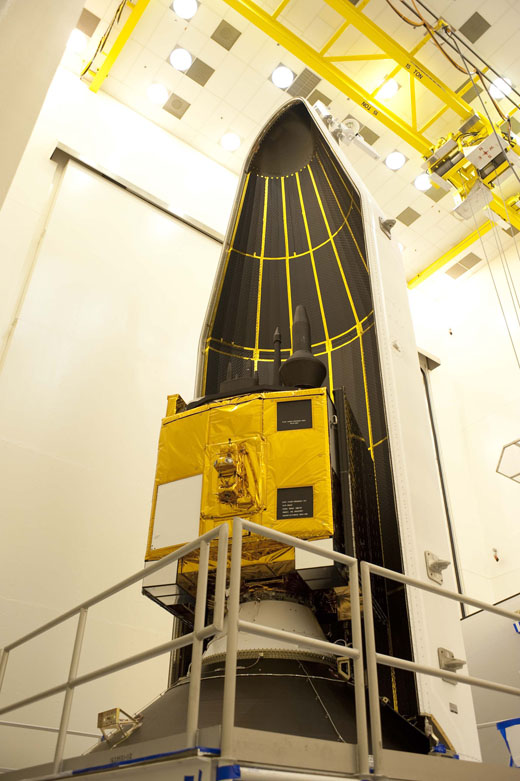
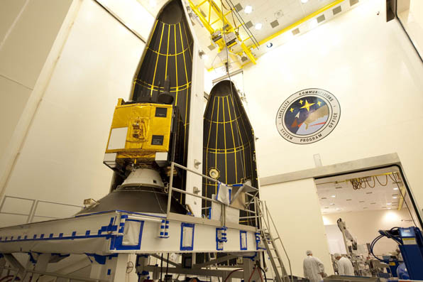
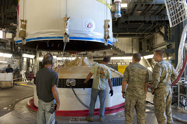
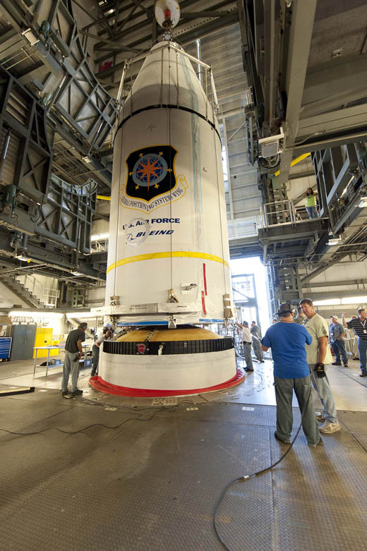
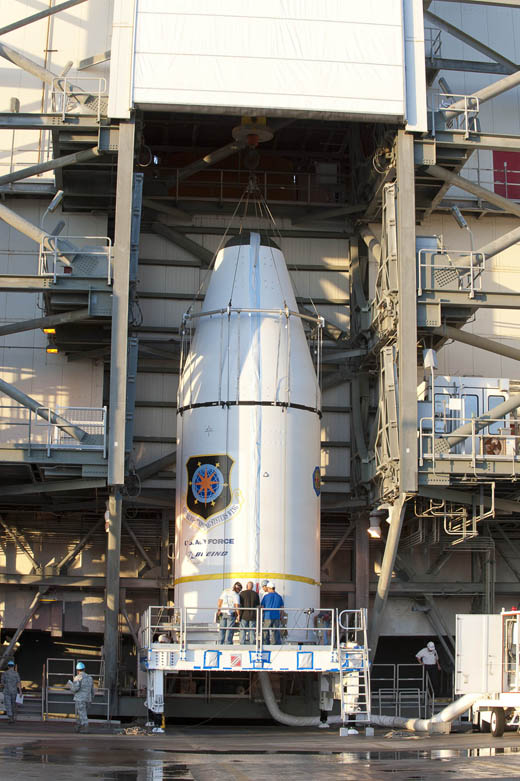
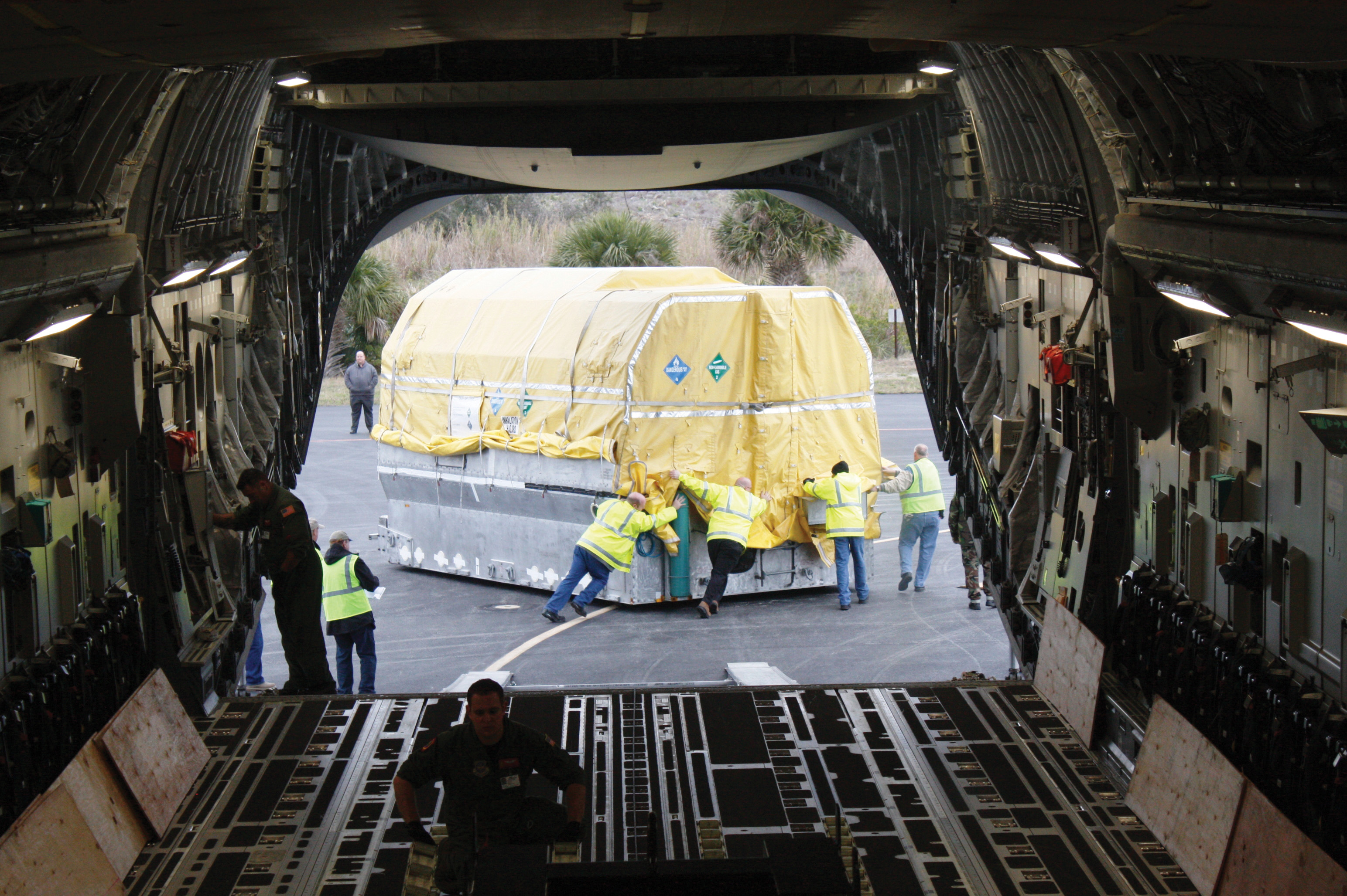
On July 9, Boeing shipped the third of 12 GPS IIF satellites for the U.S. Air Force from the company’s Satellite Development Center in El Segundo to Cape Canaveral Air Force Station, Florida, aboard a Boeing-built C-17 Globemaster III airlifter.
SVN-65 is scheduled to be launched in the fourth quarter of this year aboard a United Launch Alliance Delta IV rocket. It will join the first and second Boeing-built GPS IIF satellites, launched May 27, 2010, and July 16, 2011, to continue the sustainment and modernization of the GPS network.
“As each IIF satellite becomes operational, we continue the seamless transformation of the GPS constellation into an even more accurate, reliable and durable navigation resource for the U.S. military and the global civilian user community,” said Craig Cooning, vice president and general manager of Boeing Space & Intelligence Systems. “Our efficient pulse-line manufacturing process, adapted from Boeing’s commercial airplane production lines, also ensures that we deliver each spacecraft on time and on cost.”
SVN-65 will now undergo preflight checkout, fueling, and integration to prepare for the early October launch. When on orbit, it will be controlled by the Operational Control Segment, the GPS network’s ground control system. Developed by a Boeing-led team, the OCS entered service in 2007 and was turned over to the Air Force 50th Space Wing in April 2011.
GPS IIF features greater navigational accuracy through improvements in atomic clock technology, a more secure and jam-resistant signal for the military, and a protected, more precise, and interference-free civilian L5 signal for commercial aviation and search-and-rescue operations. Other enhancements to the IIF include an extended 12-year design life and a re-programmable on-orbit processor that can receive software uploads for improved system operation.
Of the remaining nine IIFs that Boeing is building for the Air Force, three are complete and in storage, and six are being assembled and tested.
A Close Look at GPS SVN62 Triple-Frequency Signal Combinations Finds Carrier-Phase Variations on the New L5
By Oliver Montenbruck, André Hauschild (DLR/German Space Operations Center), Peter Steigenberger (Technische Universität München), and Richard B. Langley (University of New Brunswick)
The recently launched Block IIF satellite (SVN62/PRN25) is the first of a new generation of GPS satellites designed to transmit ranging signals for civil users on three frequencies: the C/A-code on L1 at 1575.42 MHz, the L2C-code on L2 at 1227.60 MHz, and the I5/IQ codes on L5 at 1176.45 MHz. Unlike L2, the L5 signal is located inside the protected Aeronautical Radionavigation Services (ARNS) band, which makes it specifically useful for safety critical aviation applications. In combination with the legacy L1 signal, civil aviation users can now perform ionospheric corrections without referring to the L2C signal. Compared to L2C, the new L5 signal offers a much higher chipping rate (the same as the encrypted P-code signal) of 10.23 MHz, which promises a lower ranging noise and better multipath resistance. L5 signals have already been transmitted for some time by the geostationary satellites of the United States’ Wide Area Augmentation System (WAAS) and are now about to become an integral part of the GPS constellation.
Following a short test transmission on June 17, 2010, the L5 signal was continuously activated on the morning of June 28. According to GPS officials, the checkout of the satellite is proceeding nominally and all signals have been found to fully comply with specifications. This will allow the satellite to be set healthy as soon as all commissioning tasks have been completed.
Scientists have long discussed the potential of new signals for multi-frequency, multi-GNSS applications, and expresed a great interest in signal combinations, particularly those of carrier-phase measurements, involving all three frequencies simultaneously. The use of triple-frequency combinations has, for example, been demonstrated to be of great interest for ambiguity resolution in precise carrier-phase-based positioning, for receiver autonomous integrity monitoring, and for ionospheric research (see the articles in Further Reading).
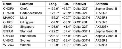
In consideration of the multitude of proposed applications for triple-frequency combinations, we took a close look at the quality of the new GPS L5 carrier-phase signal. For this purpose, we made use of measurements from the COoperative Network for GIOVE Observation (CONGO), jointly established by the German Federal Agency for Cartography and Geodesy (BKG) and the German Aerospace Center (DLR). CONGO is the first network of multi-constellation, multi-frequency GNSS receivers offering worldwide tracking of the SVN62 space vehicle on all frequencies (see Table 1).
Table 1. Subset of CONGO stations used for triple-frequency tracking of the new Block IIF satellite.
As suggested by Andrew Simsky (see Further Reading), the availability of carrier-phase measurements on three frequencies offers a particularly simple way to assess carrier-phase quality and multipath effects. By forming a linear combination
(1)
of the L1, L2, and L5 carrier-phase ranges with the additional conditions ,
a geometry- and ionosphere-free measurement is obtained, which reflects a weighted sum of the carrier-phase multipath and measurement noise on the individual frequencies. Here λ i with i = 1, 2, and 5, denotes the wavelength of the L1, L2, and L5 signals, respectively. Since the above conditions determine the factors α, β, and γ only up to an arbitrary scaling factor, we furthermore impose the normalizing conditions.
The latter condition ensures that the noise of the tri-carrier combination will match that of the individual carrier phases if the measurement noise is equal on all frequencies. As a result, we obtain the coefficients
with .
Introducing the carrier wavelengths of the L1, L2, and L5 signals, the coefficients attain the values (2)
It can be recognized that the tri-carrier combination is dominated by the L2 and L5 signals due to the proximity of their respective frequencies. Noise and multipath errors of L2 and L5 measurements are thus most prominently seen in the resulting combination, whereas any L1 phase errors are strongly attenuated.
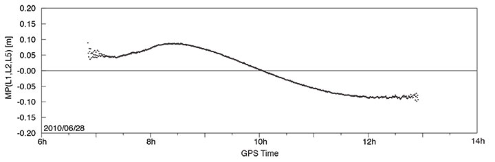
A long pass of L1, L2, and L5 code and phase measurements from the new Block IIF satellite was recorded by the O’Higgins station of the CONGO network shortly after the activation of the L5 signal generator on June 28. The SVN62 satellite was tracked for more than 6 hours and achieved a peak elevation angle of more than 75° on this date.
Figure 1 shows the resulting multipath combination computed from carrier-phase measurements of L1 C/A-code tracking, semi-codeless L2 P(Y) tracking (rather than L2C), and L5 I/Q tracking. The data have been leveled to a zero mean over the entire pass to remove the impact of the unknown carrier-phase ambiguities. Except at low elevation angles, near rise and set of the satellite where signal strengths are low, the tri-carrier combination shows a very low noise level that is consistent with the expected carrier-phase noise on all three frequencies. However, a pronounced long-term variation with a peak-to-peak amplitude of almost 20 centimeters may be recognized, which certainly comes as a big surprise and cannot be explained by local multipath. Frequency-dependent differences of the effective phase centers of the receiving or transmitting antennas can likewise be excluded, since these would result in a purely elevation-angle-dependent variation.
FIGURE 1. Triple-frequency (M=0.142·L1-0.767·L2+0.626·L5) carrier-phase multipath combination for SVN62/PRN25 tracking from the OHIX0 station on June 28.
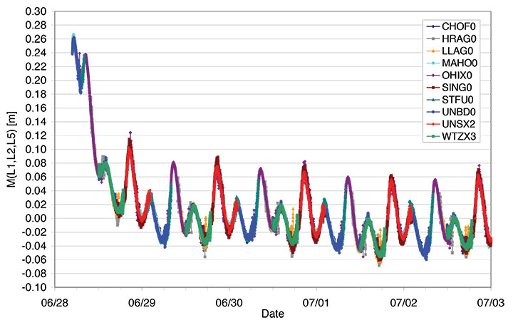
Looking at the entire set of measurements from all available CONGO stations, we could rapidly recognize that the variation of the tri-carrier combination with time is essentially the same for all stations with a common visibility of the SVN62 space vehicle, irrespective of the employed receiver and antenna. This suggests the presence of time-varying inter-frequency biases in the L1, L2, and L5 carriers transmitted by SVN62.
Thanks to the global distribution of the CONGO stations, the SVN62 space vehicle is always tracked by one or more stations, which enables a continuous monitoring of the L1/L2/L5 carrier-phase consistency. By adjusting the unknown offset of the tri-carrier combination for individual tracking arcs in such a way as to obtain a best match of consecutive and overlapping arcs, the variation can be traced over multiple days as shown in Figure 2. The graph shows a distinct orbital (that is, 12-hour) periodicity with a superimposed twice-per-revolution harmonic. In addition, a pronounced drift can be recognized for up to one day after activation of the L5 signal generator. Both observations suggest a temperature-dependent line bias in one or more carriers as a likely cause of the observed variation in the tri-carrier combination. (A line bias is a circuitry delay common in all observed satellites and is usually absorbed in the estimated clock offset.) However, an independent analysis of SVN62 temperature data from the onboard telemetry will be required to confirm the validity of this assumption. The space vehicle is in a deep eclipse orbit right now and therefore experiences substantial changes in its thermal conditions. However, the extreme points of the carrier-phase variation in Figure 2 are slightly shifted with respect to the local space vehicle noon (at 01:30 and 13:30 UTC) and the eclipse intervals (07:00–08:00 and 19:00–20:00 UTC).
FIGURE 2. Triple-frequency carrier-phase combination (M=0.142·L1-0.767·L2+0.626·L5) for the first five days of L5 activation on SVN62. The curve has arbitrarily been shifted to obtain a near-zero mean during the final days of the entire arc.
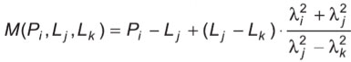
While the tri-carrier combination provides a very sensitive measurement for the analysis of differential delays between the individual carriers, it does not allow us to uniquely attribute the observed variations to one of the three signals. We therefore made use of code measurements (pseudoranges) to further investigate the consistency of specific sets of measurements. Since the observed variation of the tri-carrier combination exhibits an amplitude comparable to the noise level of the code measurements, a suitably chosen code-carrier combination can indeed help to identify which signal or signals are affected by line-bias variations. To this end, we consider a generalized form
of the well-known code-multipath combination, in which we difference the code measurement Pi at frequency i with an ionosphere-corrected combination of carrier-phase ranges Lj and Lk at frequencies j and k. In so doing, we remove geometric contributions along with clock and atmospheric variations, leaving primarily code multipath, receiver noise, and any signal perturbation that is not coherent on the involved frequencies. In the traditional case of dual-frequency tracking, the frequency of one of the involved carrier-phase measurements is necessarily identical to that of the code measurements. With triple-frequency tracking, in contrast, we are free to consider a larger variety of combinations. For the analysis of the SVN62 signals, we have specifically evaluated the L5 code-multipath combination using (a) the L5 and L1 carrier phases
and (b) the L2 and L1 carrier-phase measurements
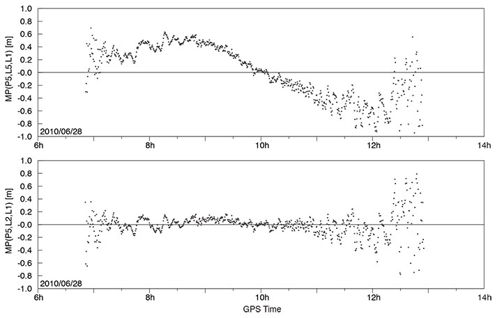
The results shown in FIGURE 3 reveal a dramatic difference, which clearly hints at the L5 carrier as the main source of the observed carrier-phase variations.
FIGURE 3. L5 code-multipath combination formed with L1/L5 carrier-phase measurements (top) and with L1/L2 carrier-phase measurements (bottom). The figure is based on SVN62 tracking from the O’Higgins station and covers the same arc as considered in FIGURE 1.
In the first case, a variation close to that of Figure 1 is obtained, albeit with a 5–6 times larger amplitude that reflects the different weighting of the L5 carrier phase in the corresponding measurement combinations. A good consistency, in contrast, is obtained for the L5 code measurements when differenced against the ionosphere-corrected combination of L1 and L2 carrier-phase measurements.
Overall, we may conclude that the L5 carrier of the SVN62 space vehicle exhibits quasi-periodic line-bias variations with an amplitude of about 10 centimeters in relation to the L1 and L2 carriers. The L5 code measurements, in contrast, appear to be consistent with both the code and phase measurements on L1 and L2 at the respective noise levels. Further observations at a later time will be required to see whether the observed amplitude of the L5 phase variation is specific to the current eclipse orbit and whether it will possibly become lower when a higher angle of the Sun with respect to the orbital plane (the so-called beta-angle) is achieved.
What are the possible consequences of the L5 phase-bias variations for users of the new L5 signal? Evidently, new positioning services building on the L5 code measurements (and possible combinations) will not at all be affected! Even in the case of carrier-phase smoothing, the smoothing time scale will be much shorter than the periodicity of the carrier-phase bias variation. The L5 code measurement quality itself is well within the system specification and no concerns exist that would prevent the satellite from soon being declared healthy.
With respect to carrier-phase-based positioning applications, it is important to note that the L5 line bias acts like an additional frequency-specific satellite-clock offset. This has, for example, been confirmed in preliminary tests of SVN62 orbit determination conducted by the Technische Universität München. Orbit solutions using L1 and L5 measurements from the CONGO network differed by typically 15 centimeters (3D root-mean-square error) from reference orbits obtained by the Center for Orbit Determination in Europe analysis center using the IGS L1/L2 receiver network. At the same time, however, the L1/L5-based clock solutions showed a periodic offset from the L1/L2-based values that reflects the same variations as the tri-carrier combination discussed above.
As a common error for all receivers, the L5 line bias fully cancels in differential processing. Care must be taken though, that satellite clock offsets derived from L1/L2 carrier-phase observations cannot be employed for precise point positioning using L1/L5 measurements without explicit consideration of the inter-frequency carrier-phase bias. Likewise, efforts to correct second order ionospheric effects through the use of triple-frequency measurements are likely to suffer from an imperfect knowledge of the L5 bias and its variation with time.
Whereas some of the proposed ideas for triple-frequency processing may be difficult to materialize at present, a better characterization of the SVN62 L5 signal will certainly help to exploit the available benefits of the new signal and to establish refined processing schemes for scientific and other demanding applications. A continued monitoring of the L5 line bias and its variation with time is therefore deemed necessary and should be supported by a large number of suitably equipped tri-band GNSS monitoring stations.
— Oliver Montenbruck, Andre Hauschild (DLR/German Space Operations Center), Peter Steigenberger (Technische Universität München)
Richard B. Langley (University of New Brunswick)
Acknowledgment
The authors are grateful to Tom Stansell and Col. David Goldstein from the GPS Wing for early discussions and their independent assessment and interpretation of the SVN62 triple-frequency carrier-phase data.
Equipment
The CONGO network makes use of JavadTriumph Delta-G2T/G3TH and LeicaGRX1200+GNSS GNSS receivers for tracking GPS signals on the L1, L2, and L5 frequencies. The stations are equipped with TrimbleZephyr Geodetic II or LeicaAX1203+GNSS and AR25R3 antennas.
Further Reading
“The WAAS L5 Signal: An Assessment of Its Behavior and Potential End Use,” by H. Rho and R.B. Langley in GPS World, Vol. 20, No. 5, May 2009, pp. 42–50.
“Using Multi-Frequency for GPS Positioning and Receiver Autonomous Integrity Monitoring” by Y.-H. Tsai, F.-R. Chang, W.-C. Yang, and C.-L. Ma in Proceedings of the 2004 IEEE International Conference on Control Applications, Taipei, Taiwan, September 2–4, 2004, pp. 205–210.
“Triple Frequency Ambiguity Resolution Using GPS/Galileo” by O. Julien, M.E. Cannon, P. Alves, and G. Lachapelle in European Journal of Navigation, Vol. 2, No. 2, May 2004, pp. 51–57.
“Three’s the Charm — Triple Frequency Combinations in Future GNSS” by A. Simsky in Inside GNSS, Vol. 1, No. 5, July/August 2006, pp. 38–41.
“Total Electron Content Monitoring Using Triple Frequency GNSS Data: A Three-Step Approach” by J. Spits and R. Warnant in Journal of Atmospheric and Solar-Terrestrial Physics, Vo. 70, No. 15, December 2008, pp. 1885–1893, doi:10.1016/j.jastp.2008.03.007.
It has long been accepted that we may reasonably expect any new technical device to have some growing pains. If you examine the history of the space program you will discover evidence of this. In the case of the first GPS IIF vehicle on orbit we do not have a 12,552-mile screwdriver. but we do have dedicated software and systems engineers at Boeing and in the U.S. Air Force that will solve the issues that crop up and eventually present the world with a stable PNT platform.
I bring this to your attention because researchers at the German Aerospace Center (DLR) say they have found a small variance in the L5 signal on IIF-1. The signal variation results in no more than a 5-centimeter error with a predictable periodicity of about six hours. While observing the IIF, DLR also reports that the signal appears to be “hot” or stronger than anticipated or advertised by about 1/2 db.
Initial reaction from the GPS Wing and Air Force experts at Schriever AFB is that the signal fluctuation appears to be temperature-related, as the periodicity correlates directly to the temperature extremes the satellite is experiencing at this time of year in its MEO orbit. It is being investigated as a matter of course during the standard checkout of the satellite, which will continue for about another four weeks according to the original checkout schedule.
The GPS Wing is confident that all the IIF signal specifications will be met by the time the satellite is set healthy in about a month’s time and they will be able to move forward with the IIF launch schedule as planned. Obviously this could be perturbated by having to make corrections or adjustments to the satellites still to be launched, but this is normal procedure, and some leeway to correct anomalies is built into the schedule for the first few launches of any new satellite system.
Privately, one official commented, “It turns out that no one has ever made this measurement before. The Galileo SVs can only broadcast from 2 transmitters at a time so they are combining two E5 signals generated from the same transmitter. Furthermore, their data was collected during max Beta meaning when they weren’t in eclipse (less thermal variance).”
The press release from the GPS Wing reads as follows.
SMC Update. July 19 — “Officials from the Air Force Space Command, Space and Missile Systems Center’s Global Positioning Systems Wing announced the “on-orbit checkout” of the first IIF satellite is progressing as scheduled. “Nearing the half way point of its 90-day checkout period, GPS IIF SV-1 also known as SVN 62/PRN 25, is currently broadcasting the same L1 and L2 signals as previous GPS satellites and the new safety of life signal known as L5. All three signals being broadcast from SVN 62 are set unhealthy while experts monitor the quality and characteristics of the signals and the performance of the satellite.
“During the initial phase of testing, [DLR] combined L1, L2, and L5 signals in a technique used to characterize a number of known and modeled error sources from the signals. This three-frequency combining technique helps isolate “other” sources of location error, such as multi-path (when more than one path exists for signals to travel before reception), receiver errors, satellite induced errors and unmodeled phenomena. The L1, L2 and L5 signals from SVN-62 are operating nominally but DLR noticed higher residual errors than expected compared to previous somewhat similar measurements from Galileo’s GIOVE-A R&D satellite.
“The GPS Wing at Los Angeles Air Force Base has corroborated DLR’s results and is investigating root cause to share a deeper understanding of this new signal’s behavior with the user community. The causes of the phase variation are still being investigated, but they are likely the result of sensitivities to changes in the satellite’s thermal environment. SVN 62/PRN 25 is currently experiencing periods of both sunlight and total darkness (known as eclipse season) as the satellite orbits the Earth and traverses through Earth’s shadow. Tests to characterize the satellite’s performance during continuous sunlight exposure will continue after the current eclipse season ends later this month.
“Typical GPS receivers using stand-alone (single signal – L1, L2 or L5) or combinations of L1, L2 and L5 signals as part of their navigation solution will not be affected by this small phenomenon. The Air Force is committed to maintaining excellence in GPS navigation and timing services and to working with the user community to best use and exploit the new modernized GPS signals.
“When tests of this new generation of GPS satellites have been completed and Air Force leadership gives approval, the satellite signals will be set healthy and will operate as specified in the Interface Control Documents (ICDs).”
At press time, GPS spacecraft IIF-1 was set to be launched May 27 from Cape Canaveral Air Force Station in Florida. This first of a new generation of satellites will travel quickly — instead of taking several days to reach its orbital slot, the new satellite should make the journey in three-and-a-half hours.
The new IIFs will broadcast the operational civil L5 signal, intended for safety-of-life applications. It will be compatible with Galileo, GLONASS, and QZSS, with the goal to be interoperable as well. L5 will transmit at a higher power than current civil GPS signals, with wider bandwidth and lower frequency that may enhance indoor reception.
IIF-1 caught its breathless ride aboard a Delta 4 rocket from the United Launch Alliance, a joint venture of Lockheed Martin and Boeing, formed in late 2006.
Earlier GPS satellites rode on smaller Delta 2 rockets that, although reliable, did not possess the oomph to place space vehicles directly into the orbiting constellation, 11,000 miles high. Delta 2s put satellites into highly elliptical orbits looping from as low as 100 miles above Earth at perigee to the 11,000-mile apogee. At a strategic point, a solid-fuel kick motor attached to the satellites pushed them into position for circular orbit on high.
The more powerful Delta 4 will shoot the IIFs directly into their destination slots. Future IIF launches may also use similarly equipped Atlas 5 rockets. The next IIF satellite, GPS IIF-2, could rise aboard an Atlas 5 as early as November.
The IIF generation, manufactured by Boeing for the U.S. Air Force, is designed not only to broadcast the new civil L5 signal, but have a longer design life of 12 years and faster processors with more memory. “These next-generation satellites provide improved accuracy through advanced atomic clocks, a more jam-resistant military signal, and a new civil signal that benefits aviation safety and search-and-rescue efforts,” said Craig Cooning, vice president and general manager, Boeing Space and Intelligence Systems.
“GPS IIF will increase the signal power, precision, and capacity of the system, and form the core of the GPS constellation for years to come,” said Air Force Col. David Madden, GPS Wing commander.
A total of 12 IIF satellites will make their contribution to getting the new L2C and L5 signals closer to operational capability before the GPS III generation takes over, beginning with a 2014 launch.
As the first spacecraft in the GPS IIF series, GPS IIF-1 underwent stringent and comprehensive testing following shipment to the launch site in February. Tests included verification of key satellite functions as well as end-to-end system testing to verify operations between the satellite and the ground control segment at Schriever Air Force Base in Colorado.
Commands were sent from Schriever to GPS IIF-1 at Cape Canaveral to turn on payloads, reprogram processors, and verify interoperability with user receivers and equipment, both civil and military.
Launch of the satellite, originally scheduled for May 20, was delayed four times because of various technical problems.
The first Block IIF satellite destined for orbit arrived at the Navstar Processing Facility at Cape Canaveral, Florida, aboard an Air Force C-17 cargo aircraft on February 12. It is now undergoing preparations for its launch this spring on a Delta IV rocket. Block IIF will enhance GPS performance by reportedly providing twice the navigational accuracy of heritage satellites, more robust signals for commercial aviation and search-and-rescue, and greater resistance to jamming in hostile environments.
New L5 Signal. The new IIFs will broadcast the operational civil L5 signal, whose spectrum allocation was secured by broadcast of the signal by a IIR(M) satellite last year. L5, at 1176.45 MHz, lies in the Aeronautical Radionavigation Services band and can be used for safety-of-life aviation. It will be compatible with Galileo, GLONASS, and QZSS, with the goal to be interoperable as well. L5 will transmit at a higher power than current civil GPS signals, with wider bandwidth, and lower frequency that may enhance indoor reception.
More L2C Beacons. The IIF generation will also add to the number of satellites on orbit that broadcast the L2C signal at 1227.6 MHz, bringing it closer to full operational capability. L2C enables the development of lower-cost, dual-frequency civil GPS receivers for correction of ionospheric time-delay errors. Once the control segment modernization is complete, enhancements such as dataless and pilot channels for improved performance and an improved navigation message with more precise clock and ephemeris information will be available. L2C will also be interoperable with the Quasi-Zenith Satellite System (QZSS) under development by Japan.
Long Life. Built by Boeing, the IIF has a longer design life of 12 years, faster processors, and more memory. It will be followed by 11 other IIFs before modernization shifts into a higher gear with the GPS III generation.
It takes four hefty guys to wheel the new satellite along the tarmac, but it will only take one Delta IV rocket to lift it 20,171 kilometers into space on May 13.
Some Receivers Run Afoul of GPS Ground Control Software Update
On January 11, 2010, when the GPS Wing and the 2nd Space Operations Squadron (2SOPS) loaded the updated AEP 5.5C software to the ground control segment, a problem surfaced with a specific subset of GPS selective availability anti-spoofing module (SAASM) receivers.
The GPS Wing did not revert to the previous AEP 5.4 because of the upcoming IIF-SV1 launch. The scheduled sequential AEP 5.5C and AEP 5.5D updates are required before the ground control segment can adequately manage the more advanced capabilities of the IIF satellites.
One purpose of the 5.5C AEP update is to enable SAASM functionality in coded receivers. The software for this functionality has been resident in various certified SAASM receivers for some time, but was never implemented in the ground control segment. The update alleviates that problem for the majority of SAASM receivers, but for one manufacturer it has caused problems. The updated software sends a specific code to SAASM receivers that enables them to authenticate the message and ensure that the code is correct, and is being sent from the GPS and not some other source. For most receivers this worked without a hitch, but for one manufacturer, a software (SW) bug or glitch occurred that must be corrected before the receiver can authenticate. This fix is in progress and will most likely be implemented as a software or firmware update to the receivers.
Timing. Another problem with a different set of receivers manifested itself exactly two weeks after the AEP 5.5C update occurred. Those that have researched this problem in some depth feel that the problem is totally unrelated to the AEP update and would have occurred regardless.
This is also considered to be a receiver software bug for the manufacturer, and that process is ongoing.
ICD. Prior to activating the software update, the GPS Wing issued an updateable ICD or Interface Control Document that all receiver manufacturers use as a voluntary guide to determine compliance. Strict compliance by the manufacturer with the receiver interface control document (ICD) may have prevented the first issue, but the second may be a serendipitous event of the type that occurs from time to time no matter what precautions are taken.
The GPS Wing has issued two Notice Advisory to NAVSTAR Users (NANUs) for civilian and commercial GPS users and for military users, asking for user comments.
Letter to the Editor. Meanwhile, a reader wrote in: “I have issues with misleading e-mails containing inaccurate titles of articles posted on the site. There have been multiple cases recently claiming AEP software (SW) upgrades caused problems with receivers. In fact, and as proven by the vendors involved and others analyzing the problems, the AEP SW did not cause any of the observed conditions. ICD noncompliance of SAASM user equipment (UE) caused the problems, and the AEP SW upgrade allowed DoD, FAA, and vendors to finally discover the noncompliance issues and begin the process to resolve them. The community should view the 5.5 SW upgrade for what it is: a valuable new capability implemented correctly, which helped us all understand some unexpected shortcomings in UE.”
The editor concurs, and apologizes for misleading article titles. However, hard information was scant — in fact, completely unavailable — at the time.
GLONASS Gets Regional; Beidou Moves; Galileo Inks
The three new GLONASS-M satellites launched on December 14 have been set operational: GLONASS 730 in orbital slot 1 was set healthy on January 30, joining 734 and 733, which were set healthy earlier in the month. This brings to 18 the number of satellites currently in service, although GLONASS 722 continues to provide a healthy signal only on its L1 frequency. At present, the constellation only suffices to provide a 24-hour regional signal over Russian territory, although satellites can and frequently are pulled in by global high-precision users to complete an RTK solution, along with GPS.
Two satellites are in maintenance mode and set unhealthy, and two others, launched in 2003 and 2005, respectively, are in the process of being decommissioned.
The next GLONASS launch, of the GLONASS Block 40 satellites originally set to rocket up last September but returned to the Reshetnev factory with problems in the signal generator, is scheduled for March 2. Three more will rise in August, and a November 10 booster will put two GLONASS-M satellites and the first GLONASS-K satellite into orbit.
Beidou. According to tracking data from the United States Strategic Command, Beidou’s G1 satellite has drifted from its original location of 160°E and is currently at about 147°E longitude, that is, no longer in geostationary lock. Perhaps it is moving to another assigned Beidou slot, to back up or replace one of the other satellites in the constellation, but this can be no more than speculation. Hard data on the Beidou/Compass system is extremely difficult to come by. The new Chinese government Beidou/Compass website does not provide up-to-date information on the status of the constellation — something we take for granted with GPS, GLONASS, and Galileo.
Galileo. The European Space Agency signed contracts for Galileo’s full operational capability phase on January 26: with OHB for the manufacture of 14 satellites, delivery of the first in July 2012, followed by two satellites every three months; for launch services with Arianespace; and for system support with Thales Alenia Space.
24+3 FAQ
Survey editor Eric Gakstatter posed these questions to the GPS Wing; their answers follow.
Will the satellites (SVN24, SVN26) remain healthy during their repositioning journey?
Yes. The satellites will be set unhealthy for the initial Delta-V, but will return to healthy status approximately 24 hours after initiation of the Delta-V. Initial Delta-V for SVN24 was accomplished on 13 Jan 10 and returned healthy on 14 Jan 10. SVN24 will take up to a year to reach its final destination. Initial Delta-V for SVN49 was accomplished on 21 Jan 10 and will arrive at its expanded position in Jun 10. Initial Delta-V for SVN26 will begin early Feb 10.
Why the two-year timeframe to realize the benefits when all repositioning will be complete in 12 months?
The two-year timeframe is a conservative estimate which takes into account potential operational necessities which could extend the time required for completion. We must take a disciplined approach to cover possible failures and ensure continuity of coverage during the transition. We will be adding GPS IIF vehicles to the constellation and older vehicles may fail during the transition timeframe. As vehicles are added and removed, the current plan is subject to change in order to provide the best service to all civil and military users. Some of these decisions could require additional time to complete the expanded constellation. However, benefits will likely be realized well in advance of 24 months.
What is the reasoning behind using SVN49 as a key component of the 24+3 configuration since it won’t benefit a significant portion of the civilian user community, namely aviation and marine navigation as well as other SBAS (WAAS) and DGPS users? In my understanding, the FAA’s and the Coast Guard’s user bases are primarily single-frequency pseudo-range, users who won’t be able to use SVN49.
SVN49 was selected because it is a brand new satellite with four good clocks. Although issues with SVN49’s navigation signals may make it unusable for all civil use, it could still put out a valid set of signals for military use. The Air Force team is continuing to work “open book” with civil and industry GPS experts to determine the possible outcome of SVN49. Although SVN49 is not currently healthy, GPSW and 50th SW are actively working a mitigation that may allow setting the vehicle healthy in the future. As a mitigation in case we are unable to set SVN49 healthy, SVN30 will be rephased to the same slot following a successful launch and on-orbit checkout of IIF-1. We expect to have either SVN30 or SVN49 healthy and broadcasting from the expanded slot within a 24-month timeframe. At this time, no decisions have been made and no options have been ruled out regarding SVN49.