Tag: GPS rollover

  • Seen & Heard: Karma drone down, GLONASS guides missiles

    Seen & Heard: Karma drone down, GLONASS guides missiles

    “Seen & Heard” is a monthly feature of GPS World magazine, traveling the world to capture interesting and unusual news stories involving the GNSS/PNT industry.


    Photo: Karma drone/GoPro
    Photo: Karma drone/GoPro

    Bad karma

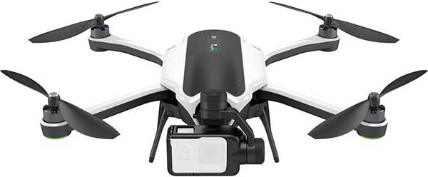
    The GoPro Karma drone has been grounded since the new year began, reports The Verge. Multiple owners say their Karma controllers are flashing errors about not receiving a GPS signal, and that they can’t calibrate the compass. They’re not able to fly the drones even after disabling GPS. A GoPro spokesperson told The Verge that it is “actively troubleshooting” the issue.


    Going wild at the casino

    A Waze ad in January misdirected drivers headed to Atlantic City’s Borgata Hotel Casino & Spa into New Jersey’s Pine Barrens. Jackson Township police helped numerous motorists stuck on unpaved roads about 45 miles from the casino, which is just off the Atlantic City Expressway. The address on the ad was correct, but the location pinned with the ad is actually in the Colliers Mills wildlife area.


    Photo: Rock penguins/Charles Bergman/Shutterstock.com
    Photo: Rock penguins/Charles Bergman/Shutterstock.com

    Feed the birds, not the mice

    Irish structural engineer John Houston used a Trimble R10 GNSS receiver and Centerpoint RTX to help mitigate a serious threat to Gough Island’s birds. The Royal Society for the Protection of Birds seeks to eradicate invasive mice left from 19th-century ships. The survey will help locate temporary infrastructure for workers to distribute poisoned bait to kill the voracious rodents, which feed on two million defenseless eggs and chicks each year. Though 1,000 kilometers from the nearest reference station, Houston achieved centimeter accuracy on all survey points. See the monster mice here.


    Photo: U.S. Marines at Al Asad Air Base in 2018. (Cpl. Jered T. Stone/Marine Corps)
    Photo: U.S. Marines at Al Asad Air Base in 2018. (Cpl. Jered T. Stone/Marine Corps)

    Missiles guided by GLONASS

    According to Israeli military intelligence website DEBKAfile, Russia gave Iran access to GLONASS to target the U.S. base in Iraq on Jan. 8. The strike injured 34 American soldiers. DEBKAfile reports that Russia-provided GLONASS access allowed Iranian missiles to hit with an accuracy of 10 meters at the Ain Assad base in western Iraq. “According to Russian sources, 19 missiles were fired from the territory of Iran, 17 of which hit the targets,” DEBKAfile said.

  • Apple warns old iPhones, iPads could hit GPS rollover problem

    Apple warns old iPhones, iPads could hit GPS rollover problem

    iPhone 4s. (Photo: Apple)
    iPhone 4s. (Photo: Apple)

    Anyone who owns an older model Apple iPhone or iPad could experience a device-breaking problem on Nov. 3, according to Apple.

    The issue could affect iPhone and iPad models introduced in 2012 and earlier.

    “If you don’t update to the newest version of iOS available for your device before November 3, some models might not be able to maintain an accurate GPS position. And functions that rely on the correct date and time—such as syncing with iCloud and fetching email—might not work,” Apple said in a blog post.

    The problem is because of the GPS time rollover on April 6. Affected Apple devices won’t be impacted until just before 12 a.m. UTC on Nov 3.

    The iOS update will solve the problem, enabling the device to maintain accurate GPS location and keep the correct date and time.

    Devices affected include iPhone 4s and 5, third and fourth-generation iPad, iPad mini and iPad 2. Learn specifics of affected models and how to update the operating system on the Apple website.

    If not updated, these devices might not be able to maintain accurate GPS position or perform functions that require accurate time, such as properly syncing with iCloud or fetching email. The devices also might not be able to receive over-the-air software updates. As a result, the only way to update the device will be to restore it via iTunes or Finder through a tethered connection.


  • Seen & Heard: Measuring Everest, GPS Rollover boo-boos

    Seen & Heard: Measuring Everest, GPS Rollover boo-boos

    Seen & Heard is a monthly feature of GPS World magazine, traveling the world to capture interesting and unusual news stories involving the GPS/GNSS industry.

    Photo: Mount Everest/Daniel Prudek/Shutterstock.com
    Photo: Mount Everest/Daniel Prudek/Shutterstock.com

    Surveying the highest height

    The precise height of Mount Everest — now listed as 29,029 feet, or 8,848 meters — has been contested since the first survey by British officers in 1849.

    On January 2020, Nepal plans to end the controversy and declare both snow and rock height of the world’s tallest mountain. This spring a two-member Nepali survey team will summit the mountain with a Trimble R10 GNSS receiver, gifted by New Zealand.

    Besides a GNSS survey at the summit, teams will conduct precise leveling, trigonometric leveling and gravity surveys. The GNSS survey will cover 285 points with 12 different observation stations, nine of which are in hills of Sankhuwasava, Bhojpur and Solukhumbu districts.

    Photo: e-Golf cars/Volkswagen
    Photo: e-Golf cars/Volkswagen

    Takin’ it to the (Hamburg) streets

    Five electric Volkswagen Golfs are now on the streets of Hamburg, Germany, being tested with Level 4 automation.

    The cars are designed to handle complex urban traffic patterns without help from drivers, although they must be ready to intervene.

    Level 5, the highest category, requires the vehicle to perform all tasks, turning every rider into a passenger.

    The cars are driving 1.9 miles (3 km) of urban roads where new signals and traffic management systems have been installed for autonomous driving.

    Boeing 787 Dreamliner Hainan airlines/aapsky/Shutterstock.com
    Boeing 787 Dreamliner Hainan airlines/aapsky/Shutterstock.com

    GPS Rollover gone wrong

    The April 6 GPS Week Number Rollover was supposed to pass without a hitch, with plenty of notice that updates might be required for legacy receivers. Instead, several systems crashed.

    In China, as many as 15 Boeing 777s and 787s were grounded pending a GPS update (the receivers gave the date as August 22, 1999.)

    In New York City, part of the wireless grid faulted, cutting information feeds to the NYPD (license plate cameras) and remote worksite communications.

    In Australia, weather balloons were grounded. In the United States, NOAA autonomous monitoring stations went offline. Fixes for all these systems are underway.

  • CGSIC issues notice to mariners on GPS Rollover Event

    Credit: Damen
    Photo: Damen

    The Coast Guard Navigation Center has published a special notice to mariners that use GPS equipment. The special notice outlines the details of the GPS Week Number Rollover that will occur April 6-7.

    To best prepare for the rollover event, users of GPS equipment who are concerned should update their firmware, or contact their equipment manufacturer to ensure their equipment is ready for this event.

    When the week number reaches 1024 at 18 seconds before midnight (UTC) on April 6, it will reset to zero as it keeps counting. This has happened once before, in August 1999.

    Recent devices have likely been designed to handle the rollover event.

    Older GPS receivers, however, or receivers that have not been provided manufacturer updates, may be affected by the rollover. The impact might occur in April, or could affect such equipment at a later date. The date might revert back to August 1999, or may revert to another date. Since this issue does not affect the other parts of the GPS navigation message (it only affects the date), the receiver’s ability to calculate the position and to display the exact time of day should not be impacted.

    Additional information about GPS and the GPS Week Number Rollover is available here:

    Civil GPS users are encouraged to report disruptions or anomalies to the U.S. Coast Guard Navigation Center or via phone at 703-313-5900, 24 hours a day.

  • Homeland Security provides info about 2019 GPS rollover event

    The U.S. Department of Homeland Security (DHS) has released a memorandum about a GPS rollover event coming in April 2019.

    The memorandum, U.S. Owners and Operators Using GPS to Obtain Time, is intended to provide an understanding of the possible effects of the April 6, 2019, GPS Week Number Rollover on Coordinated Universal Time (UTC) derived from GPS devices.

    DHS recommends that critical infrastructure and other owners and operators prepare for the rollover. They should:

    • investigate and understand their possible dependencies on GPS for obtaining UTC;
    • contact the GPS manufacturers of devices they use to obtain UTC;
    • understand the manufacturers’ preparedness for the ollover;
    • understand actions required by CI and other owners and operators to ensure proper operation through the ollover, and
    • ensure that the firmware of such devices is up to date.

    The memorandum is sponsored by the Department of Homeland Security’s National Cybersecurity and Communications Integration Center in coordination with the Department of Homeland Security’s Science and Technology Directorate, the Department of Homeland Security’s National Protection and Programs Directorate Office of Infrastructure Protection and the National Coordination Office for Space-Based Positioning, Navigation and Timing.

    GPS World discussed in-depth the previous rollover event in an Innovation column.