When the U.S. Air Force shot down a Chinese balloon flying at 60,000 ft (11.4 miles) on Feb. 4, the incident raised many questions about international security, international law, U.S.-China relations and technology. Among them, where is the end of a nation’s airspace — the portion of atmosphere it controls above its territory? Its horizontal boundary corresponds to that of its land border and territorial waters, which extend 12 miles out from its coastline. However, there is no international agreement on the vertical boundary.
The 1967 Outer Space Treaty — to which the United States is a party and which bans “appropriation” of outer space by any nation — omits a definition of “outer space” because none of the major powers wanted to limit their own freedom of action in space. At a United Nations meeting in Vienna in 2001, the U.S. delegation said, “Our position continues to be that defining or delimiting outer space is not necessary.”
The United Nations has historically accepted as the boundary of space the Kármán line, at an altitude of 62 miles above mean sea level. It roughly marks the altitude where traditional aircraft cannot effectively fly using lift generated by Earth’s atmosphere, because the air there is just too thin. The Fédération Aéronautique Internationale agrees with this definition.
Some countries have adopted a definition for their own legal purposes, usually based on either the Kármán line or on the altitude at which orbital flight is possible without utilizing atmospheric lift. As a courtesy, a state launching a space vehicle that will traverse another state’s territory during its sub-orbital flight will notify the overflight state.
The U.S. military and NASA on the other hand, define space to begin at 50 miles above Earth’s surface. “Pilots, mission specialists, and civilians who cross this boundary are officially deemed astronauts,” according to the U.S. Department of Commerce’s National Environmental Satellite Data and Information Service.
Escaping Earth’s atmosphere entirely is another story. It requires traveling at least 600 miles, to its outermost layer, where violent solar winds have greater sway than air. If that were the definition of space, however, the Space Shuttle (which orbited up to 200 miles up), the International Space Station (205 miles to 270 miles), active Earth observation satellites (280 miles to 500 miles), some of the National Oceanic and Atmospheric Administration’ s polar-orbiting satellites (540 miles) and most scientific satellites, including nearly all of NASA’s Earth Observing System fleet, would not be considered spacecraft! Lower orbits have significant air-drag, which requires frequent orbit re-boost maneuvers.
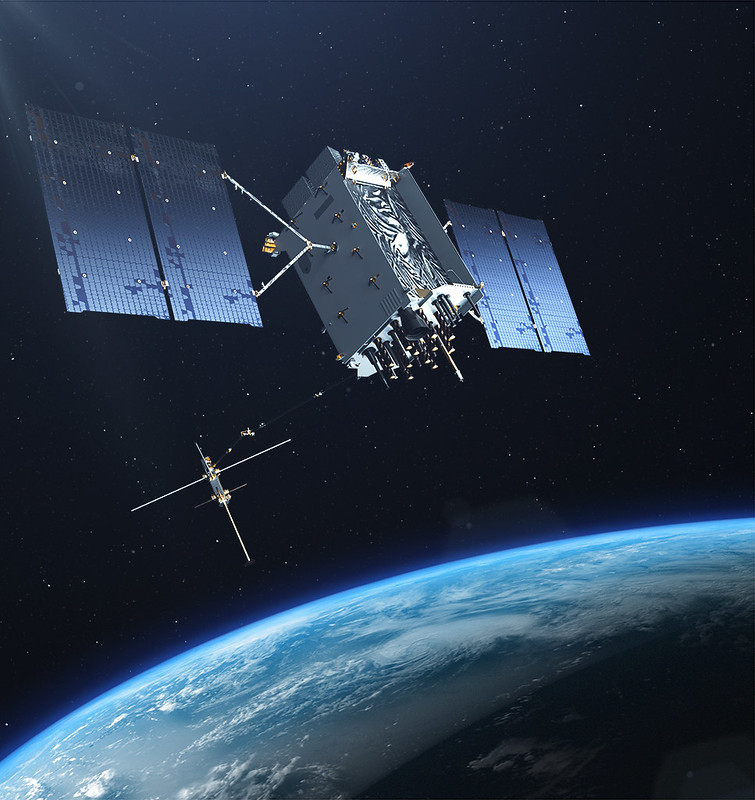
There’s no question that GPS satellites, orbiting at an altitude of about 12,550 miles, are in space. That is why they are acquired, sustained, and operated by the U.S. Space Force (USSF), established in December 2019 as the newest branch of the U.S. armed forces. Its mission is to organize, train and equip space forces to protect U.S. and allied interests in space and provide space capabilities to the joint force. As the USSF grows, we’ll hear more about it.
GPS is the gold standard for precise positioning, navigation, and timing (PNT), impacting the lives of more than six billion users worldwide. The United States economy alone depends on the free, government-provided service across 900 million GPS receivers supporting vehicle navigation systems, general aviation, financial transactions, the electrical grid, precision agriculture, surveying and construction. The GPS enterprise must remain consistent and reliable, while keeping pace with emerging technology without interruption for the end user.
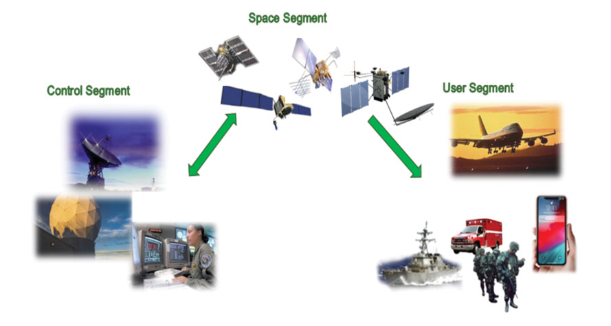
Space Systems Command (SSC) at Los Angeles Air Force Base in El Segundo, California — the U.S. Space Force’s space development, acquisition, launch and logistics field command — is responsible for maintaining and modernizing the GPS enterprise. The enterprise consists of three segments: the space segment, the control segment and the user segment. Each achieved specific milestones during an exciting and productive 2022.
A new MGue for warfighters is moving closer to completion. (Image: EvgeniyShkolenko/iStock /Getty Images Plus/Getty Images)
Space Segment
There are currently 37 GPS satellites on-orbit with 31 set healthy. The constellation requires 24 operational satellites for worldwide coverage and a receiver needs to receive transmissions from four of them to determine its position in three dimensions. GPS continues to operate impressively with an average 45-cm accuracy throughout the past year with the most precise day on record at 31.5 cm. The space segment of GPS modernization focuses on GPS III and GPS IIIF satellite development with significant milestones rounded out in 2022.
For GPS III, after the successful launch of Space Vehicle 5 (SV05) on June 17, 2021, it was set healthy (usable) on May 25, 2022. The significance of SV05 is its full operational capability of the improved civilian L2 (L2C) signal. L2C improves service speed for commercial users via access to two frequencies, improves accuracy when combined with legacy civil GPS signals (L1 C/A), and is less susceptible to ionospheric interference. SV05 is the 24th satellite enabled with the Military Code (M-code), providing worldwide M-code coverage. M-code is designed to give military receivers better defense against jamming, improved accuracy, a more secure and flexible cryptography architecture, and the ability to detect and reject false signals.
On Jan. 18, 2023, SV06 successfully launched into orbit aboard a SpaceX Falcon 9 Block 5 rocket from Cape Canaveral Space Force Station, Florida. The launch of SV06 marks a key step in the larger goal of modernizing the GPS constellation. Additionally, the 10th and final satellite in the GPS III fleet finalized production and has a target launch date of 2026. GPS III Space Vehicles 7–10 are in storage and available for launch.
The next generation of GPS satellites continues development. The October 2022 contract award for GPS III Follow-On (GPS IIIF) satellites will onboard additional capabilities. In addition to introducing new civil signals designed to enhance search-and-rescue efficacy and aviation safety, laser retroreflector array for precise ranging, and a fully digital navigation payload, the GPS IIIF satellites will offer a new Regional Military Protection (RMP) capability providing up to 60 times greater anti-jamming measures. A new port on the Lockheed Martin LM2100 Combat Bus supports a substantial increase in flexibility, providing rapid integration of payloads in response to emerging threats in space.
GPS Enterprise interrelated segments. (Image: Space System Command)
Control Segment
The Next Generation Operational Control System (OCX) will replace the current GPS Operational Control System (OCS), supporting the latest U.S. Department of Defense standards and practices for cybersecurity. The updated system includes a modernized and expanded monitor station network, improved anti-jam capabilities, and enhanced operational capability to control modernized military signals.
In March 2022, OCX completed its fourth and final legacy ground antenna element (LGAE) installation on Kwajalein Island in the Republic of the Marshall Islands. OCX Block 1 and 2 are undergoing Hewlett Packard (HP) Formal Qualification Test (FQT). This event will qualify much of the system’s previously certified mission software functions. The event will also demonstrate system maturity and readiness for system acceptance, operator training, and specific developmental testing milestones with both GPS space and user segments.
The next-generation control system, OCX 3F, will modify OCX Blocks 1 and 2 to use the enhanced capabilities of GPS IIIF satellites. OCX 3F received Milestone B and Acquisition Program Baseline (APB) approval from the Milestone Decision Authority (MDA) and was authorized to enter the Engineering and Manufacturing Development (EMD) phase in May. In November, the OCX 3F program deployed 3F mission software into OCX’s Near Operations Environment (NOE) for the first time after completion of the program’s first Integration Readiness Review (IRR). The IRR event ensures that the software meets integrity standards and receives approval to be integrated and tested on the NOE prior to software releases to the operational users. OCX 3F anticipates achieving operational acceptance in 2027.
The GPS III government and industry team recently core mated GPS III SV10 and nicknamed it “Hedy Lamarr” after the actress and inventor. (Image: Lockheed Matin)
User Equipment Segment
Among the arsenal of GPS user equipment, very few pieces have the technology to use the M-code signal. Maintaining a competitive advantage against the adversary requires use of these signals; the GPS Enterprise is focused on developing Modernized GPS User Equipment (MGUE) capable of accessing these signals. The MGUE program is a joint service program developing modernized M-code-capable military GPS receivers. The program is broken into two increments (Inc 1 and Inc 2). Both are designed to deliver secure PNT performance, allow navigation warfare operations, enhance anti-jam, enhance anti-spoof and anti-tamper, and enable Blue Force Electronic Attack.
As part of the multiple elements under the MGUE Inc 1 umbrella, L3Harris delivered its final Build 7 ground card to the government on Nov. 16, 2021, and completed regression testing on that kit in February 2022. The final Delta Security Certification and Approval were completed on April 13 and April 29, 2022, respectively. Development of the L3H Ground-Based GPS Receiver Applications Module (GB-GRAM-M) card, which delivers geolocation and precise positioning capabilities for space-constrained applications while providing increased security and anti-jam capabilities, is complete and available for services procurement. MGUE Inc 1 completed qualification testing for the aviation and maritime cards on Sept. 9, 2022, with updated software builds. This build allows the program to progress to 98% of the requirements verified and enables B-2 Bombers and Guided Missile Destroyers (DDG) to continue progress toward operational testing. Completion of this commitment means significant progress toward operational testing for stakeholders and warfighters.
MGUE Inc 2 held Preliminary Design Reviews for the Miniature Serial Interface (MSI) in summer 2022, bringing the project another step closer to finalizing the EMD phase. Once all closure and action items are completed for the reviews, the government will consider each event complete. Critical Design Review (CDR) is scheduled for this summer and will validate the system design and the ability to meet system performance requirements. MGUE Inc 2 continues to execute the second competitive objective under Phase I for the Joint Modernized Handheld component; the effort is moving closer to completion of the handheld prototype and will ultimately make for a more seamless transition to operations.
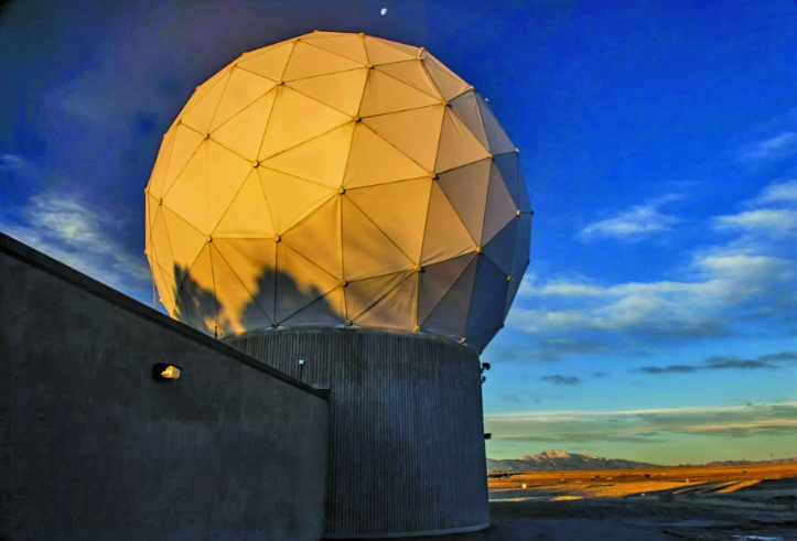
GPS ground antenna at Schriever Space Force Base in Colorado. (Image: U.S. Air Force)
Conclusion
The SSC’s mandate is paramount to maintaining our modern way of life. The space professionals dedicated to developing GPS technology are committed to delivering advanced capabilities to the warfighter, the civil sector, and the world. An interconnected world is ready for us. We’re on our way.
SSC is the U.S. Space Force field command responsible for acquiring and delivering the capabilities needed by warfighters to protect our nation’s strategic advantage in and from space. It manages an $11B budget for the U.S. Department of Defense and works in partnership with joint forces, industry, government agencies, academic and allied organizations to outpace emerging threats.
For analogous updates on the other three GNSS constellations, please see:
It was 2018. Representatives from the European Space Agency were visiting Google headquarters in Mountainview, California.
Under discussion was Europe’s plans to introduce a high accuracy and authentication service to their Galileo satellite navigation system. Galileo would broadcast precise point positioning corrections on the E6-B band and provide users decimeter-level accuracy. They would also be including a navigation authentication message enabling receivers to distinguish genuine messages from deceptive ones sent by spoofers.
Wouldn’t Google like to incorporate these capabilities in future versions of Android phones?
The answer from Google Distinguished Engineer, Frank van Diggelen, was a resounding “yes.”
Technologically Possible
Van Diggelen also had another thought. It should be possible to deliver precise positioning corrections and authentication data via the internet. This could allow phones with an internet connection to access the services as well. With an app, older smartphones would be able to take advantage of the services, and it wouldn’t be necessary to add new hardware to new phone designs.
The next logical step was to establish an internet-based high accuracy and authentication service for the United States’ GPS. Unlike the newer European Galileo and Chinese Beidou systems, GPS satellites don’t have the ability to transmit data to improve accuracy and authenticate signals.
Yet a couple of process challenges in the United States could make establishing such a service difficult and might prevent its creation entirely.
Data collection and use not yet an official program
The first is related to the way in which the U.S. collects and handles real-time tracking data of the Global Navigation Satellite Systems (GNSS) — GPS, GLONASS, Galileo, and BeiDou — to derive corrections needed for a high accuracy service.
NASA’s Jet Propulsion Laboratory (JPL) operates NASA’s Global GNSS Network (GGN) of more than 60 stations around the globe, which provide their tracking data to JPL’s Global Differential GPS (GDGPS) System. The GDGPS System also has access to real-time tracking data from hundreds of additional sites, all of which track GPS and other GNSS. This allows the GDGPS System to generate precise corrections for the navigation messages of GPS and other GNSS. It also enables real time decimeter-level accuracy for positioning applications anywhere in the world. These corrections are provided to some government agencies and commercial entities on a reimbursable basis.
NASA’s GDGPS capabilities are not part of a formal, official government program, though. Rather they have grown organically as part of JPL’s efforts to push boundaries in scientific and engineering applications of GNSS, and its ability to take on work paid for by other agencies. Thus, GDGPS efforts lack a sufficient and established government funding line, formal programmatic tasking, and other structures and procedures needed to ensure its long-term viability as a government-provided service.
NASA and JPL officials recognized this and in 2020 established a working group to advise on how they should go forward. The following year that working group made several recommendations to NASA and the PNTAB. Among them were to establish a consistent level of NASA funding, create a Level-1 capabilities document for GDGPS, and start discussions towards an interagency memorandum of understanding (MOU) for long-term government funding.
At the same time, a PNTAB task force investigated the GDGPS activity and made recommendations to the PNTAB. They included: that NASA/JPL document GDGPS capabilities, including architecture, facilities, functions and products; that a stable government funding line for GDGPS be established; that a security review of GDGPS be undertaken; and to maintain GDGPS entrepreneurial aspects in pursuing multi-agency usage of its services.
Civil GPS rarely needs addressed
The second challenge to establishing high accuracy and authentication service for GPS appears to be the lack of an identified agent or mechanism within the federal government to do so.
Europe’s Galileo is a civilian system established and operated to support economic activity and development. The U.S’s GPS is run by the military.
First created to “put five bombs in the same hole,” it was built and run for years by the U.S. Air Force and is now the responsibility of the U.S. Space Force. Its primary mission is support of military missions and almost all funding comes through the Department of Defense (DOD).
Yet, indisputably, 99% of GPS users are not in the military and the system has become essential to most technologies and nearly every facet of the U.S. economy.
Official government policy has long recognized this, at least at the strategic level. Presidential policies issued in 2004 and in 2021 provided for improvements in functionality for civil users – as long as they were required by and entirely funded by a civil agency.
At a more tactical level, though, attempts to fund civil requirements have always faced great difficulty and rarely succeeded.* Mandates in presidential directives for civil signal monitoring, interference detection and mitigation, increased resilience, alternative PNT, and responsible use have all faced uphill battles and received little funding.
According to former senior government officials, this difficulty stems from civil GPS use being caught in a bureaucratic “Catch-22.”
On the one hand, executive branch policy dictates that funding for GPS capabilities and applications benefiting civil users must flow through the Department of Transportation (DOT). On the other, within government programming and budgeting circles, GPS is seen as an expensive military capability funded through the DOD. Requests for GPS and PNT-related funding through DOT are more difficult to explain and are easier to deny.
Compounding this difficulty is the lack of a clear and empowered national leader to advocate for a comprehensive and national approach to GPS and PNT issues and overcome bureaucratic snags.
As a result, the path forward for adopting the recommendation for a GPS high accuracy and resilience service is, at best, unclear.
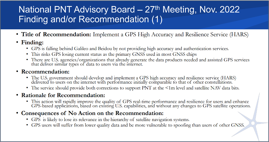
Yet many on the President’s advisory board and in government are hopeful. “Establishing a high accuracy and resilience service for GPS is the right thing to do” said one. “We have all the pieces to make this happen. We just need to bring them together.”
And as one of the board members commented at the recent meeting, if the U.S. doesn’t do this “It stinks.”
Image: Slide from the National PNT Advisory Board Meeting in November 2022
*The exception to difficulties funding civil GPS-related capabilities is the Federal Aviation Administration’s Wide Area Augmentation System. It was established as the result of heavy lobbying by the airline industry, which continues to give it strong support.
The U.S. Coast Guard Navigation Center has issued a notice that GPS satellite SVN-77 (PRN-14) was set healthy for initial use on Dec. 2 at 0131Z. This follows the U.S. Space Force announcement that the satellite, the fourth GPS III (SV04), received Operational Acceptance approval on Dec. 1.
SVN-77 is the 23rd satellite to broadcast L2C, the second civil GPS signal at 1227.6 MHz. L2C is not yet designated as “operational” by the U.S. Space Force.
However, the L2C signal is set to healthy, and users can utilize this signal at their own risk.
The U.S. Air Force’s Lockheed Martin-built next generation GPS III satellite on orbit. Rendering portrays GPS III Space Vehicles (SVs) 01-10. (Artist’s Rendering: Lockheed Martin)
SVN-77 is the 16th satellite to begin broadcasting the third civil GPS signal, L5, specifically designed for aviation use in an internationally protected band of spectrum designated for aeronautical navigation at 1176.45 MHz. L5 continues to broadcast an unhealthy designation.
SVN-77 is the fourth satellite broadcasting the new L1C signal at 1575.42 MHz.
The next GPS III satellite, SVN-78, initially scheduled to launch in January, will launch no earlier than July 1, 2021.
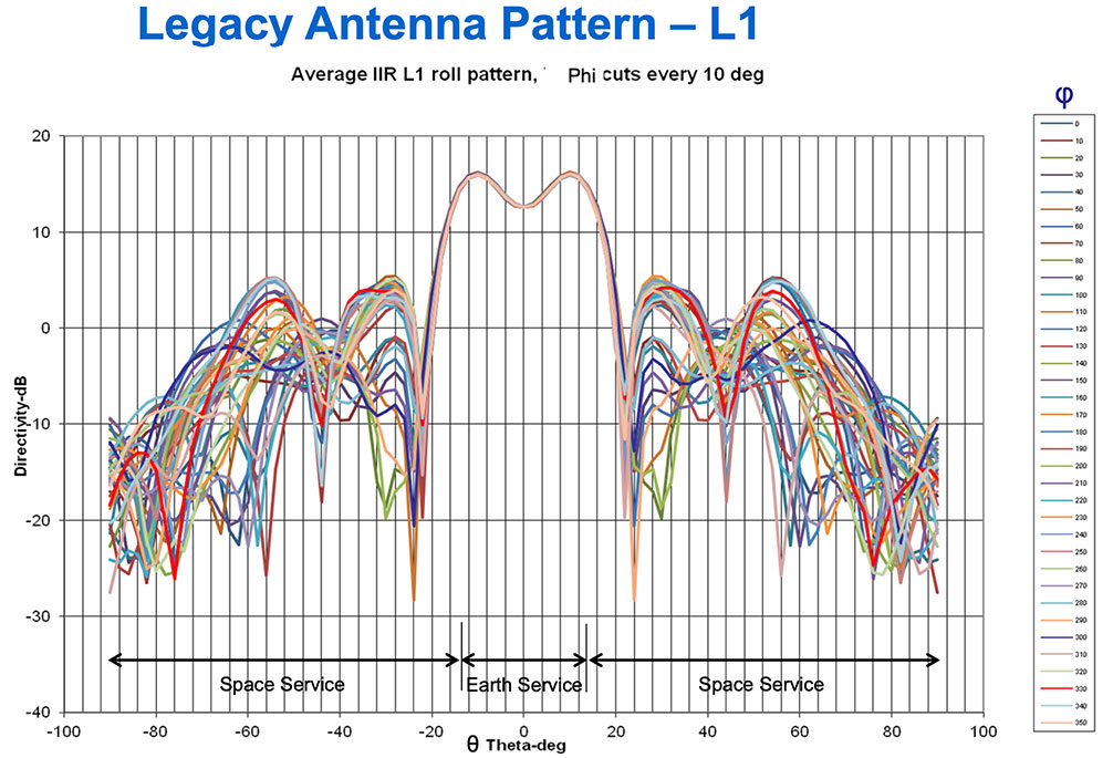
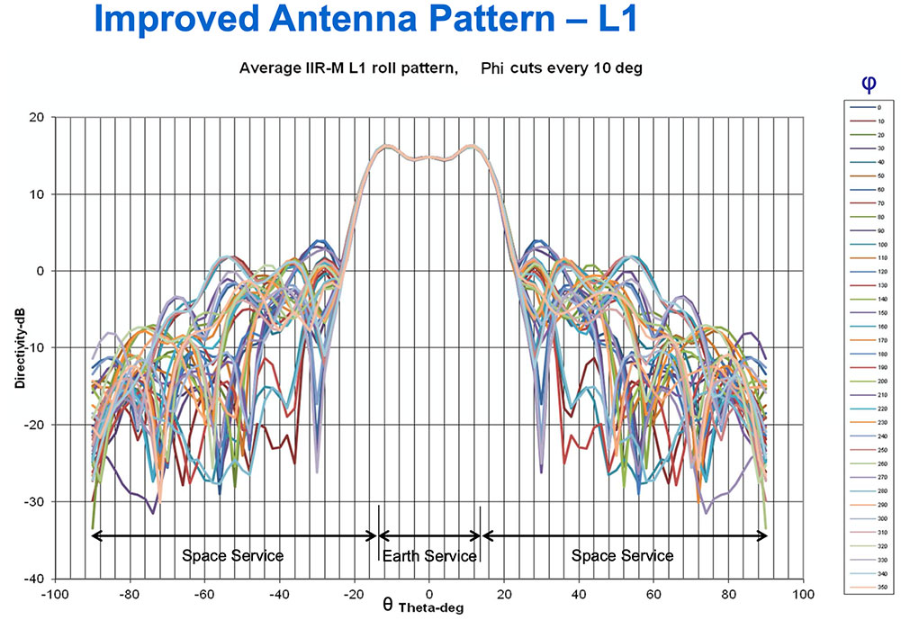
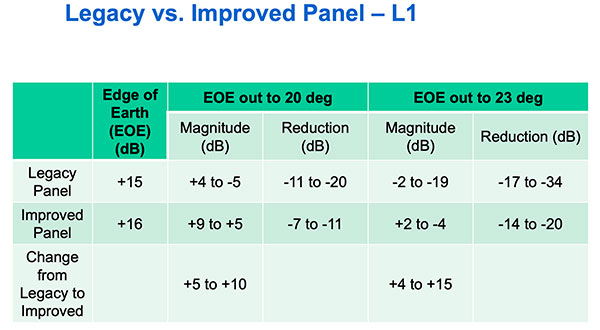
Partnering with the U.S. Coast Guard Navigation Center (NAVCEN), U.S. Space Force and Lockheed Martin Space have released the GPS IIR/IIR-M satellite antenna patterns for worldwide public use.
Additionally, the Institute of Navigation has offered a related ION journal article free to the public to accompany the antenna patterns.
The GPS Block II Replenishment (IIR) space vehicle (SV) began improving upon its baseline design in 2003 with the launch of the first Block IIR SV retrofitted with a redesigned antenna panel. This is the Earth-facing panel providing the GPS L-band broadcast signal. The improved antenna panel includes redesigned L-band elements mounted on the SV Earth-facing structure in the same manner as the original antenna panel.
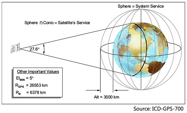
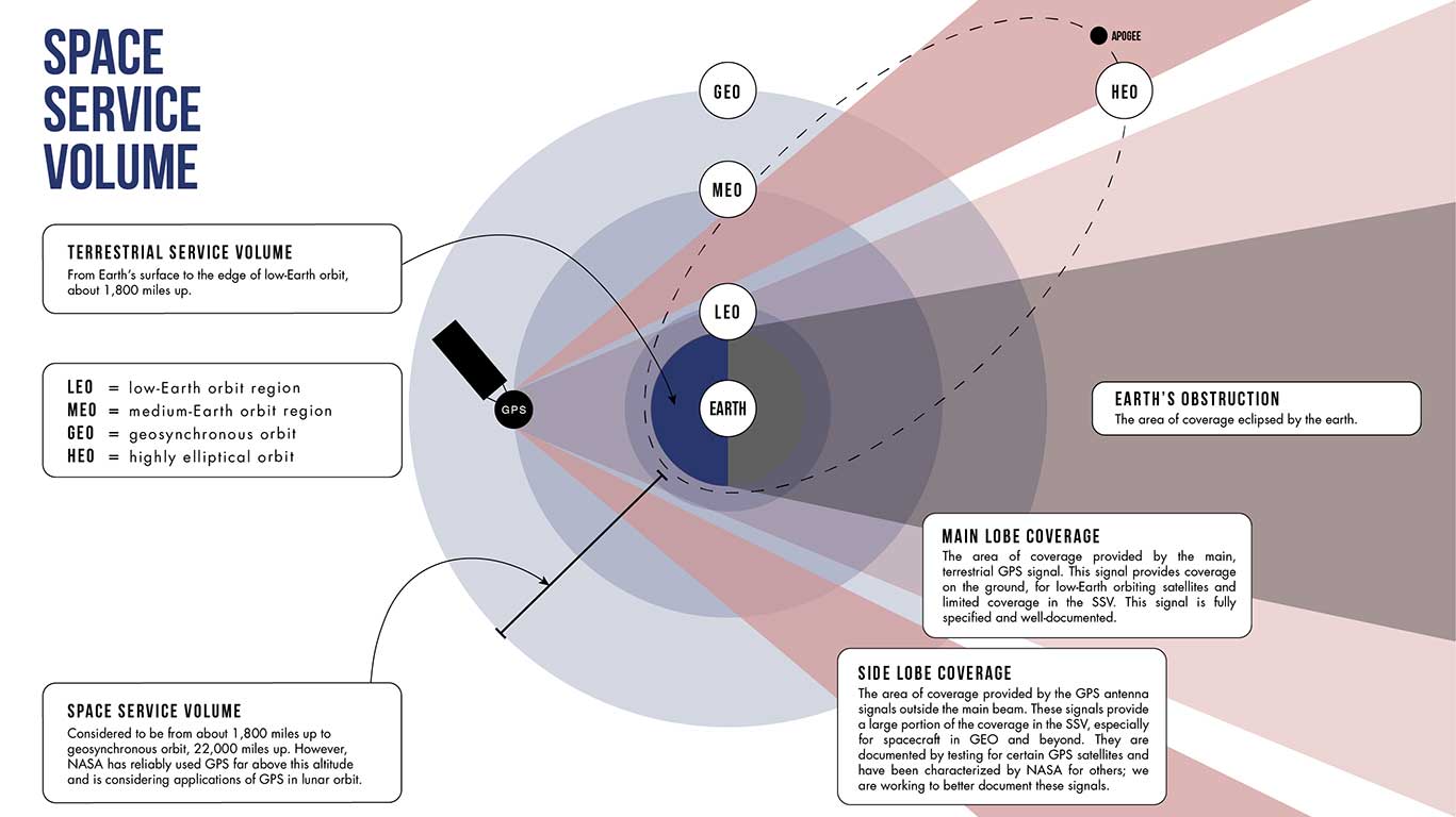
The Earth Terrestrial Service Volume is the near-Earth region up to 3,000 km altitude. (Diagram: NAVCEN/Lockheed Martin)
Spacecraft Navigation
The use of GPS signals for spacecraft navigation has increased in general over the last few decades. Navigation employing GPS observations for spacecraft in low-Earth orbit is now considered routine.
However, the situation is quite different for spacecraft that fly in the Space Service Volume above the GPS constellation, including medium-Earth orbit (MEO), geostationary orbit (GEO) and high-Earth orbit (HEO) satellites, as well as missions to the Moon and beyond.
For these spacecraft, reception of GPS transmit antenna side lobe signals is essential to improve availability and performance of on-board navigation and timing. In this context, the knowledge of the full antenna pattern (main lobe and side lobes) from the transmitting antennas of each of the GPS satellites is essential.
These published antenna patterns and associated ION citation describe both IIR and IIR-M antenna panel versions, their broadcast signal patterns, the performance observed in factory testing, and their on-orbit performance.
Chart: NAVCEN/Lockheed MartinChart: NAVCEN/Lockheed MartinChart: NAVCEN/Lockheed Martin
These patterns represent the current capability of the GPS IIR/IIR-M Space Vehicles. Receiver designers should consult the IS-GPS-200 specifications for use in receiver design and not base design on current signal performance.
GPS technical documents are also available at the NAVCEN website and linked from the GPS.gov website.
Legacy antenna panel on the GPS IIR satellite. (Photo: NAVCEN/Lockheed Martin)
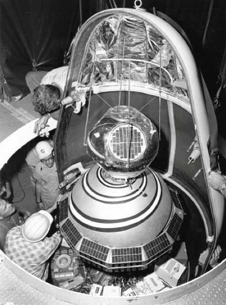
1960: ARPA launched Transit, the first satellite in what would become the world’s first GPS. (Photo: U.S. Army/DARPA)
Sixty-three years ago, on Friday, Oct. 4, 1957, the Space Age began — most everyone alive today is a progeny. The Soviet Union sent a shiny, metal, beach-ball-sized sphere into orbit. Sputnik beeped every second for 21 days before going silent. Its beeps were heard ’round the world. Using the Doppler effect, a listener could tell whether the tiny satellite was moving toward or away from them. Scientists pinpointed the satellite’s exact location by observing it in a single pass, and realized the reverse could also be true. A terrestrial observer’s unknown location could be derived from the known orbit of a single satellite. That idea turned into the first satellite navigation system.
In 1964, the Navy Navigation Satellite System (NNSS) became operational. The highly classified system called Transit was built to support the Polaris ballistic missile submarine fleet. It operated on a small constellation of less than five polar orbiting satellites. With so few satellites in orbit, it could take more than an hour to get a positional fix. Twenty-meter accuracy could be attained by using specially encrypted signals, but these were restricted to submarines. All other users of Transit could only achieve accuracy within 200 meters.
Accuracy was a challenge. The problem was solved the same way John Harrison’s chronometer solved it 300 years earlier, threading together the past and present. More accurate location required more precisely measuring time (see geospatial-solutions.com/from-the-great-pyramids-to-gis-gps/). The problem was solved by two Timation satellites launched in 1967 and 1969 to broadcast a time reference signal. Essentially, the Timation satellites were space-based chronometers.
Timation improved location accuracy, even though it took hours to achieve sub-meter precision. It proved a success, and as a result, in 1967, Transit became available for non-military users, such as surveyors. In fact, everyone today who has ever worked with a reference system is familiar with WGS 84, which was originally based on “Doppler surveying receivers” called georeceivers, referring to measurements from the Transit system. Transit was also known as NavSat as it became more broadly adopted for civilian purposes such as commercial shipping.
In 1973 the Department of Defense sought to combine the success of Transit (NNSS) and Timation into one satellite system, which evolved into the NavStar-Global Positioning System. The first launches began in 1978 and reached a full constellation of 24 GPS satellites in 1993. Since that time, Russia, Europe, China, India and Japan have all created their own constellations. All of those systems combined with GPS make up the global navigation satellite system (GNSS), which totals more than 120 satellites.
Recognizing GPS’s sustained success and positive global impact, in February 2019 the Queen Elizabeth Award for Engineering went to four of the primary developers of the GPS program for their contribution to the world. These four gentlemen are Engineering Stars. On Feb. 12 of this year, President Trump signed an Executive Order further acknowledging the value of position, navigation and timing (PNT) as the invisible infrastructure of modern society. And, on July 1, Capt. “Sully” Sullenberger addressed the Space-Based PNT Advisory Board, stating how GPS has become a universal part of every facet of our lives including financial transactions, transportation, agriculture, rescue operations, surveying and construction.
The GPS satellites are our own constellation and each of them should be named in honor of a scientist or engineer who helped conceive and develop the Transit, Timation and GPS programs; even though the earlier systems no longer exist, their legacy should long be remembered.
From those Cold War origins of a chirping beach ball traveling through space 63 years ago, now more than 2,600 satellites enhance our terrestrial lives providing better communication, location and understanding. We are all children of the stars, albeit stars of our own making.
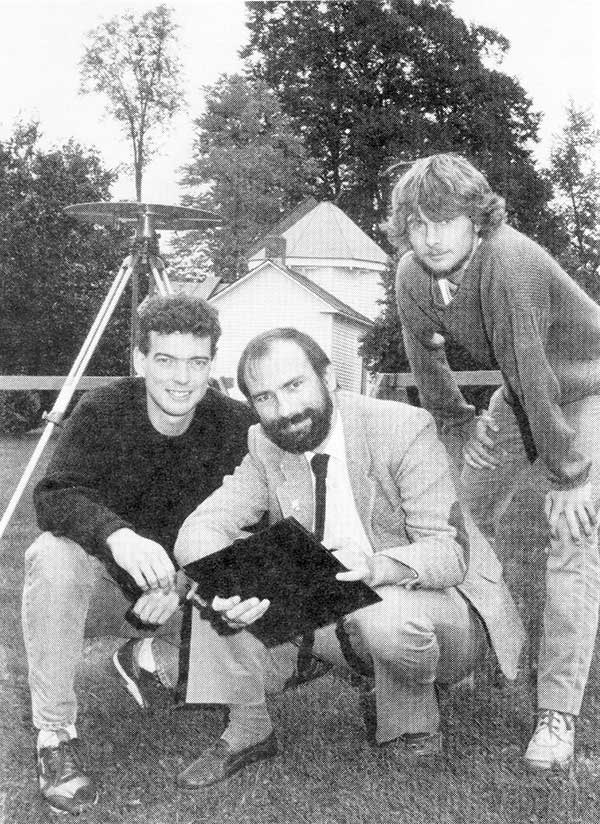
1990: UNB Professor Richard Langley and two graduate students use a GPS antenna (recognize it?) on a tripod to re-measure a historical baseline. (Photo: UNB Perspectives)
When GPS World published its first issue in January 1990, only 15 GPS satellites had been launched, including the 10 prototype or Block I satellites. And four of those early satellites had ceased operation. But there had been enough satellites in orbit for more than a decade to permit early commercial and scientific use of the system. There were even handheld receivers for personal navigation, albeit somewhat larger than those we have today. But it was clear that GPS was going to take off in a big way, and that there was a business case for launching a monthly magazine (bimonthly in its first year) about GPS for professionals in the positioning, navigation and timing communities.
The new magazine was to feature a blend of news, product announcements and articles about GPS, including cutting-edge research on GPS technology and its applications taking place at universities and research institutes around the world. That is why Glen Gibbons, the founding editor of GPS World, reached out to the University of New Brunswick (UNB), an early leader in GPS research and education, to manage a column to be called simply “Innovation.” Glen stipulated that “the column should deal with issues that have broad application and interest and are presented in terms that are accessible to as wide a range of readers as possible.”
Four faculty members were engaged in GPS research at UNB back then: David Wells, Alfred Kleusberg, Petr Vaníček (who famously foretold of the GPS watch back in 1983), and me. Dr. Kleusberg and I volunteered to manage the column and to scour academia and government and industry labs to find authors to write the column’s articles — or to write them ourselves, which we sometimes did. Beginning in 1997, I took over as the sole coordinator of the column — a role I have continued to this day.
There have been close to 300 “Innovation” articles since the first one in the premier issue of the magazine. I’ve also contributed to a number of news and feature articles in the magazine over the years. I might just be the longest-serving active GPS “journalist.” I’m still a full-time teaching and research professor at UNB, and recently took over as the editor-in-chief of The Institute of Navigation’s journal NAVIGATION, but I still have time to write for GPS World and hope to continue to serve the magazine in the years to come.
Not just supporting players, alternative positioning, navigation and timing (PNT) systems strengthen, augment and — when needed — replace GNSS. We explore how companies are using alternative PNT, and talk with John Fischer of Orolia and Alexis Guinamard of SBG Systems about their companies’ latest developments.
Since the 1990s, GPS has provided the United States military with a substantial tactical edge. Civilian GPS applications are now deeply embedded in every aspect of our lives. The U.S. Department of Transportation recently reaffirmed that GPS’ positioning, navigation, and timing (PNT) services are critical to the safe and efficient use of the national transportation system, and a Feb. 12 presidential executive order declared that satellite-based PNT services “have become a largely invisible utility for technology and infrastructure.”
It has long been equally well known, however, that GPS is vulnerable to accidental and intentional interference (the latter known as jamming), spoofing, and degradation or denial of signals. Additionally, GPS satellites are increasingly vulnerable to damage or destruction by space debris or intentional attack. The executive order mentioned above declared it U.S. policy “to ensure that disruption or manipulation of PNT services does not undermine the reliable and efficient functioning of [the country’s] critical infrastructure.”
Protecting PNT requires not just strengthening GPS, but also developing alternative sources of PNT data and ways to integrate them into the myriad systems that currently rely on GPS.
The National Timing Resilience and Security Act of 2018 (passed by the U.S. Senate as part of that year’s Coast Guard authorization act), called for “a complement to and backup for” the GPS timing component “to ensure the availability of uncorrupted and non-degraded timing signals for military and civilian users in the event that GPS timing signals are corrupted, degraded, unreliable or otherwise unavailable.” It mandated the procurement of a wireless, terrestrial system that would provide wide-area coverage and be synchronized with UTC, resilient and extremely difficult to disrupt or degrade, able to penetrate underground and inside buildings, and capable of deployment to remote locations.
A report released on April 8 by the Department of Homeland Security (DHS), however, recommends “that responsibility for mitigating temporary GPS outages be the responsibility of the individual user and not the responsibility of the federal government.” It points out that research by one of DHS’ agencies “shows that users can mitigate short-term GPS disruptions (e.g., inability to read a GPS signal) with various strategies, ranging from using local backup capabilities to delaying operations until GPS is restored.” The report then focuses on “mitigation against long-term or permanent disruption or loss of GPS PNT capabilities.” It determines that the PNT functions in critical infrastructure “are so diverse that no single PNT system, including GPS, can fulfill all user requirements and applications” and notes that maximum resilience is found in diversity of solutions. Therefore, it recommends that the federal government “encourage adoption of multiple PNT sources [to expand] the availability of PNT services based on market drivers.”
In the interviews below, I discussed these challenges with John Fischer, vice president of Advanced R&D at Orolia, and Alexis Guinamard, chief technical officer of SBG Systems.
GPS signals extend farther than expected, meaning future space missions can reliably use GPS at extreme altitudes.
By Danny Baird
NASA’s Goddard Space Flight Center, Greenbelt, Maryland
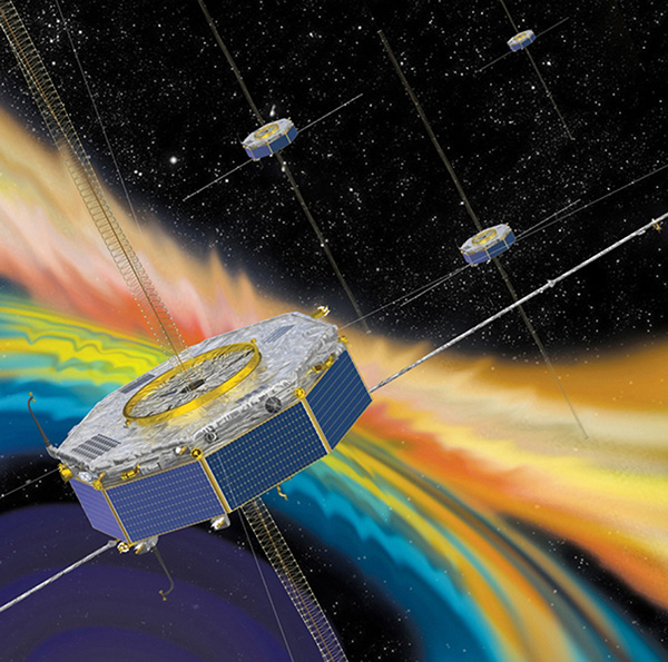
The four Magnetospheric Multiscale (MMS) spacecraft recently broke the world record for navigating with GPS signals farther from Earth than ever before. MMS’ success indicates that NASA spacecraft may soon be able to navigate via GPS as far away as the Moon, which will prove important to the Gateway, a planned space station in lunar orbit.
After navigation maneuvers conducted this February, MMS now reaches over 116,300 miles from Earth at the highest point of its orbit, or about halfway to the Moon. At this altitude, MMS continued to receive strong enough GPS signals to determine its position, shattering previous records it set first in October 2016 and again in February 2017.
This demonstrates that GPS signals extend farther than expected and that future missions can reliably use GPS at extreme altitudes.
“At the first apogee after the maneuvers, MMS1 had 12 GPS fixes, each requiring signals from four GPS satellites,” said Trevor Williams, the MMS flight dynamics lead at NASA’s Goddard Space Flight Center in Greenbelt, Maryland. “When we began the mission, we had no idea high-altitude GPS would be such a robust capability.”
MMS’ orbit shift allows it to continue its mission to better understand the complex magnetic processes around Earth. MMS studies a fundamental process that occurs throughout the universe, called magnetic reconnection, in which magnetic fields collide and explosively release particles in all directions. Near Earth, reconnection is a key driver of space weather, the dynamic system of energy, particles and magnetic fields around Earth which can adversely impact communications networks, electrical grids and GPS navigation. Magnetic reconnection was long predicted by physicists, but not directly observed until the MMS mission.
To study Earth’s magnetosphere, the region of space dominated by the planet’s magnetic field, MMS spacecraft maintain a highly elliptical orbit around Earth. A highly elliptical orbit resembles a long oval around the globe with an extreme high point, or apogee, and low point, or perigee.
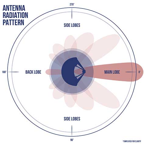
MMS’ tight formation and highly elliptical orbit require extremely accurate navigation data from GPS satellites, which are operated by the U.S. Air Force. The main GPS antenna signals enable navigation down on Earth, but precise high-altitude navigation requires both these as well as signals from the antenna’s side lobes. Side lobe signals radiate out to the side of the direction an antenna is pointing and extend past Earth.
A simplified antenna radiation pattern with different lobes of radiation extending from the antenna. (Image: NASA)
Communications engineers usually consider these side lobes wasted energy. However, the signals can be used by satellites at high altitudes on the opposite side of the globe as the GPS satellite. (Such high-altitude missions fly above GPS satellites’ orbit.) Previously, most engineers considered the upper limits of the GPS navigation in space to be an altitude of about 22,000 miles, or the altitude of satellites in geosynchronous orbit — until MMS.
Additionally, the navigation maneuvers allowed the spacecraft to gather data not available to scientists during normal operations.
“MMS usually flies in a close, tetrahedral formation [that looks like a pyramid],” said Thomas Moore, the project scientist for MMS at Goddard. “During the orbit-raising maneuvers, the spacecraft became a [straight line or] ‘string of pearls,’ which gave us unique data about the magnetosphere that may further our understanding of magnetic reconnection.”
MMS’ tight configuration and record-breaking GPS fixes would not be possible without the mission’s Navigator GPS receiver, an instrument developed at Goddard. It can detect faint GPS signals while withstanding the harsh radiation environment within the magnetosphere. NASA has made this revolutionary technology available for licensing through the Technology Transfer program, ensuring that commercial enterprise can also benefit from this innovation.
A diagram showing how GPS antenna signals can serve spacecraft at high altitudes. (Image: NASA)
In fact, NASA simulations show GNSS signals could even be used for reliable navigation in lunar orbit, just as a car uses GPS on an interstate highway. Engineers are considering using GNSS signals in the navigation architecture for the Gateway, an outpost in orbit around the Moon that will enable sustained lunar surface exploration.
“We’re working with the international community to document GNSS performance for space users, including side lobe signals,” said Joel Parker, a Goddard navigation engineer representing NASA internationally in GNSS policy. “A better understanding of GNSS capabilities will allow high-altitude missions to take advantage of the robust navigation signals they provide.”
Illustration of the four MMS spacecraft in orbit in Earth’s magnetic field. (Image: NASA).
Thanks to MMS and NASA’s navigation engineers, the sky is no longer the limit.
NASA’s Science Mission Directorate provides strategic oversight to MMS. Goddard’s Explorers and Heliophysics Projects Division manages the mission. The four MMS spacecraft launched on March 13, 2015, from NASA’s Kennedy Space Center in Cape Canaveral, Florida, on board an Atlas V launch vehicle.
NASA’s Space Communications and Navigation (SCaN) program office oversees the agency’s work in navigation policy related to GNSS. NASA, consulting the United Nations International Committee on GNSS (ICG), collaborates with other U.S. agencies and the six international GNSS providers to define GNSS requirements and develop additional capabilities. The team of SCaN navigation specialists charged with aiding the ICG are based out of the Exploration and Space Communications projects division at Goddard.
The decision means Lockheed Martin is all but assured the contract. Lockheed Martin announced on April 17 that it had submitted its proposal.
All three companies received study contracts in 2016 valued at up to $6 million each to demonstrate their ability to build future GPS satellites, in preparation for the planned competition.
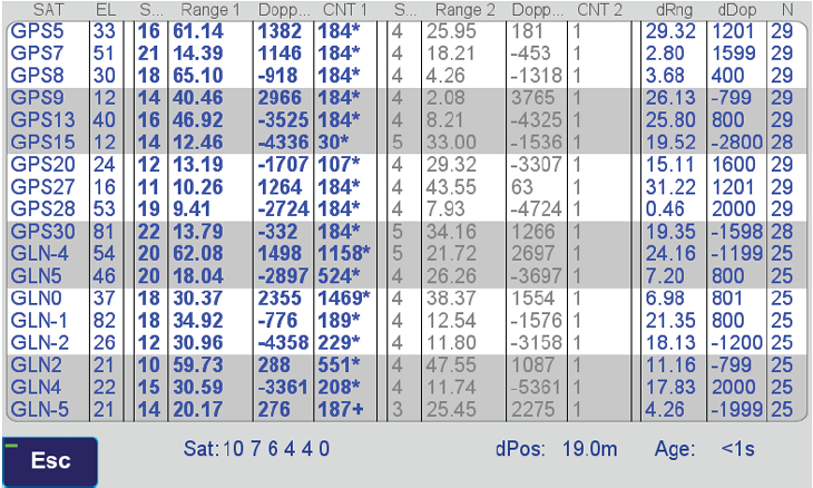
Two methods of spoofer detection, the identification and sourcing of false GNSS signals, have been released by Javad GNSS, using features available for all of its OEM GNSS boards.
Spoofer detection and alarm. This feature then identifies and isolates the spoofer signal, ignores it, and provides a position solution using only valid satellite signals.
Determination of the direction from which the spoofing signals emanate. This can aid in tracking down the actual spoofing source.
Spoofer Detection
With 864 channels and roughly 130,000 quick-acquisition correlators, the Javad GNSS Triumph chip can assign more than one channel to each GNSS satellite, in order to find all the signals that are transmitted with that satellite’s PRN code. If the chip detects more than one reasonable and consistent correlation peak for any PRN code, it concludes that spoofing is present and can the proceed to identify the spoofed signals.
In this case, it uses the position solution provided by all other clean signals (L1, L2, L5, and so on, from all GNSS constellations — GPS, GLONASS, Galileo, Beidou, and mroe) to identify the spoofer signal and use the real satellite measurement. If all GNSS signals are spoofed or jammed, then the system issues an alarm, directing the user to ignore GNSS and use other sensors in an integrated system.
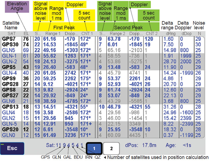
Satellite and Spoofer Peaks
The figure below shows an example of a spoofer signal and a real satellite signal received at a GNSS receiver. These screenshots are from a real spoofer in a large city. The bold numbers are for the detected peaks. The gray numbers represent highest noise, not a consistent peak. A “*” symbol next to the CNT numbers indicate that signal is used in position calculation. Each CNT count represent about 5 seconds of continuous peak tracking.
The first screenshot shows no spoofing is present. The second shows that all GPS satellites are being spoofed.
No spoofer. Only one reasonable peak for each satellite. (Table: Javad GNSS)Table: Javad GNSS
In the above screenshot all GPS satellites have two peaks and all are spoofed. We were able to distinguish the spoofer signal and use the real satellite signals in correct position calculation as indicated by the ”*” next to the CNT numbers.
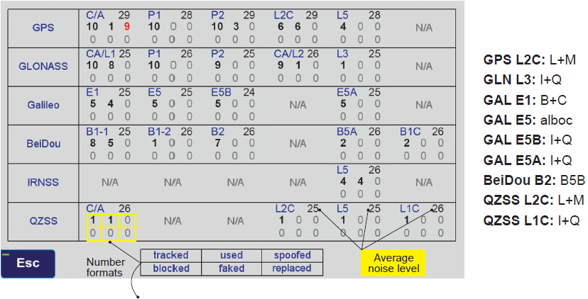
GNSS Overall View
The following screenshot shows the status of all GNSS signals. The format and the signal definitions are explained below.
Table: Javad GNSS
Tracked: Tracked by the tracking channels and has one valid peak only.
Used: Used in position calculation.
Spoofed: Has two peaks. Good peak is isolated, if existed.
Blocked: Blocked by buildings or by jamming. If jammed, shows higher noise level.
Faked: Satellite should not be visible, or such PRN does not exist.
Replaced: Real signal is jammed and a spoofed signal put on top of it. Because of jammer, it shows higher noise level.
In a specialized cleanroom designed to streamline satellite production, Lockheed Martin is in full production building GPS III — the world’s most powerful GPS satellite, according to the company. The company’s second GPS III satellite is now assembled and preparing for environmental testing, and the third satellite is close behind, having just received its navigation payload.
In May 2017, the U.S. Air Force’s second GPS III satellite was fully assembled and entered into Space Vehicle (SV) single line flow.
In May, the U.S. Air Force’s second GPS III satellite was fully assembled and entered into Space Vehicle (SV) single line flow when Lockheed Martin technicians successfully integrated its system module, propulsion core and antenna deck. GPS III SV02 smoothly came together through a series of carefully-orchestrated manufacturing maneuvers utilizing a 10-ton crane.
GPS III SV02 is part of the Air Force’s next generation of GPS satellites, which have three times better accuracy and up to eight times improved anti-jamming capabilities. Spacecraft life will extend to 15 years, 25 percent longer than the newest GPS satellites on-orbit today.
“Now fully-integrated, GPS III SV02 will begin environmental testing this summer to ensure the satellite is ready for the rigors of space,” said Mark Stewart, vice president of Navigation Systems for Lockheed Martin. “This testing simulates harsh launch and space environments the satellite will endure, and further reduces any risk prior to it being available for launch in 2018.”
A Factory Full of GPS III Satellites
Right behind GPS III SV02, eight more contracted GPS III satellites are moving through production flow at Lockheed Martin’s nearly 40,000 sq. ft., state-of-the-art GPS III Processing Facility near Denver.
GPS III SV03 recently completed initial power on of its bus, which contains the electronics that operate the satellite. The company received SV03’s navigation payload from its supplier, Harris Corporation, in May. After further system testing, SV03 will be ready for full integration later this fall.
GPS III SV04’s major electronics are being populated as it prepares for its own initial power on. This satellite’s navigation payload is expected to arrive and be integrated into its space vehicle before the end of the year.
Right behind the second GPS III space vehicle (GPS III SV02), eight more contracted GPS III satellites are moving through production flow at Lockheed Martin’s nearly 40,000 sq. ft., state-of-the-art GPS III Processing Facility (GPF) near Denver.
Components of the next six satellites, GPS III SV05-10, are arriving at Lockheed Martin daily from more than 250 suppliers in 29 states. To date, more than 70 percent of parts and materials for SV05-08 have been received. The company was put under production contract for SV09-10 in late 2016.
All of these satellites are now following the Air Force’s first GPS III satellite, GPS III SV01, through a proven assembly, integration and test flow. SV01 completed its final Factory Functional Qualification Testing and was placed into storage in February 2017 ahead of its expected 2018 launch.
Investing in the Future of GPS III
With multiple satellites now in production, Lockheed Martin engineers are building GPS III smarter and faster. Key to their success is the company’s GPS III Processing Facility, a cleanroom manufacturing center designed in a virtual-reality environment to maximize production efficiency. Lockheed Martin invested $128 million in the new center, which opened in 2011.
The company’s unique satellite design includes a flexible, modular architecture that allows for the easy insertion of new technology as it becomes available in the future or if the Air Force’s mission needs change. Satellites based off this design also will already be compatible with both the Air Force’s next generation Operational Control System (OCX) and the existing GPS constellation.
“From day one, GPS III has been a team effort and our successes would not have been possible without a strong Air Force partnership,” Stewart said. “GPS III will ensure the U.S. maintains the gold standard for positioning, navigation and timing. We look forward to bringing GPS III’s new capabilities to our warfighters and beginning to launch these satellites in 2018.”
The GPS III team is led by the Global Positioning Systems Directorate at the U.S. Air Force Space and Missile Systems Center. Air Force Space Command’s 2nd Space Operations Squadron (2SOPS), based at Schriever Air Force Base, Colorado, manages and operates the GPS constellation for both civil and military users.