Project Manager Positioning, Navigation and Timing (PM PNT) has announced the Army Contracting Command – Aberdeen Proving Ground award of two Other Transaction Authority (OTAs) via a C5 prototyping project for a mounted PNT NorthStar solution to IS4S and GPS Source.
With an estimated value of up to $41 million and 36-month period of performance, the OTAs enable the selected vendors to develop next generation of mounted Assured PNT capability that’s modular and upgradable for Army 2040 ground-based platforms.
“We’re excited to move into the next phase of NorthStar with this award,” said Chris Jais, project manager, PM PNT. “We’re confident that with our vendor partners, we’ll introduce an affordable, MOSA-compliant product with next-generation capability into our family of open solutions and continue to bring upgradable and scalable APNT products to soldiers in the field.”
PM PNT’s Modernization product office introduced the NorthStar effort in August 2023 via a virtual event and release of an RFI that received 27 vendor responses. These responses informed PM PNT’s decision to solicit industry for the design of tiers of capability that would offer a range of non-radio frequency technologies to outpace the threat of Army 2040; the responses, combined with tech evaluations and review of white papers, also led to the organization deciding to ultimately award a NorthStar OTA to more than one vendor.
“Awarding to multiple vendors encourages competition, speeds up implementation and integration of new technology to meet emerging threats, and reduces cost of engineering change proposals,” said Erik Scott, product manager for PNT Modernization. “Prioritizing a modular system design for hardware and software ensures the best value for the government and the best solution for our warfighters.”
Contract kickoffs with each vendor are scheduled for next month with design review and a soldier touchpoint to follow.
For more information on PM PNT, visit the PM PNT page on the Capability Program Executive Intelligence and Spectrum Warfare website.
GPS Source has received Global Positioning Systems Directorate security approval for its family of Selective Availability Anti-spoofing Module (SAASM)-based Host Application Equipment (HAE).
GPS Source announced security approval for the Enhanced D3 (ED3) and Enhanced FLO-G (E-FLO-G) with integrated SAASM receivers. The ED3 and E-FLO-G are upgradeable versions of the popular DAGR Distributed Device (D3) and are capable of distributing SAASM today, and M-code protected GPS data when implemented.
Enhanced DAGR Distributed Device by GPS Source.
GPS Sources’ family of PNT distribution products represents the most advanced, cost effective and comprehensive solution available on the market to support Department of Defense’s GPS modernization efforts. Moreover, the ED3 and the E-FLO-G bridge the gap between legacy systems deployed today and the C4ISR/EW architectures of the future.
“We understand the importance of designing products that comply with all GPS Directorate security requirements,” said Robert Horton, CEO of GPS Source. “This security approval makes it possible for the ED3 and E-FLO-G to be deployed by military forces without reservation. GPS Source is proud to be a key supplier of such important enablers to the warfighter and to be the provider of innovative military GPS solutions to our defense customers.”
“Integrating legacy equipment utilizing SAASM receivers with future equipment relying on M-code receivers is challenging,” Horton continued. “But through Independent Research and Development, GPS Source ensured the ED3 and E-FLO-G integrate appropriately with SAASM today and M-code in the future. These accomplishments exemplify the technology in development by GPS Source to sustain the equipment that warfighters will employ today and tomorrow.”
GPS Source has begun taking orders for the ED3 and GLI-FLO-G. Production will start mid-year. Questions about this technology can be directed to Kurt Williams, director of Sales and Marketing.
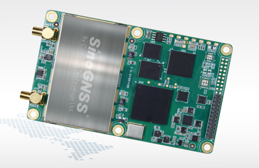
Positioning and heading for mission-critical applications
The K528G dual-frequency, multi-constellation GNSS board provides the highest accuracy in differential positioning. It benefits from numerous constellation signals because of its advanced tracking performance of both GPS and GLONASS. The K528G can provide positioning and heading information generated by two antennas. It is designed for guiding and positioning construction engines, dredges, barges, shipping container cranes, mining equipment and intelligent transportation systems.
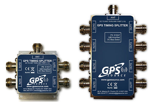
Designed for small-cell and distributed antenna systems
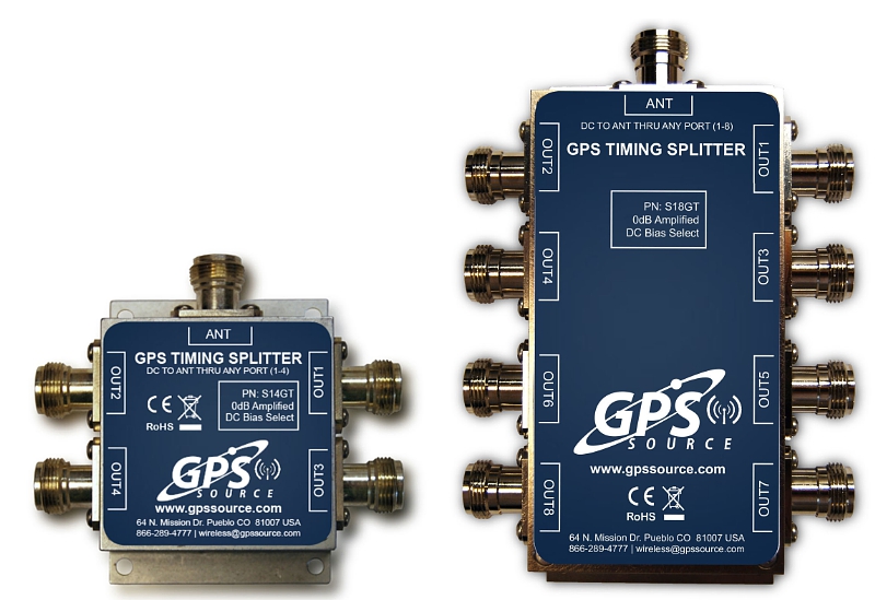
GPS Source has released of a line of GPS/GNSS splitters created for the small-cell wireless and distributed antenna system markets. Specifically designed for the L-band frequency, they can eliminate the cost of multiple antennas and long cable runs in wireless installations. With four or eight outputs, the new line of splitters make it possible to use a single GPS referencing antenna and cable arrangement for multiple synchronized systems. The splitters include features such as DC bias select and amplification. GPS Source RF signal splitters typically operate in conjunction with an active GPS antenna; consequently, a GPS RF signal splitter must have provisions for managing the DC voltage to the active GPS antenna. The S14GT and S18GT splitters will power an external GPS antenna from any of the RF outputs. A “hunt-and-pick” circuit is used to select only one DC input for power should more than one source be connected. Designed for redundancy, if the selected DC bias input should fail, the DC bias will automatically switch to another DC input to ensure an uninterrupted power supply to the active antenna.
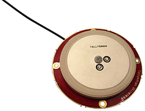
For precision industrial, agricultural and military OEM applications
A new series of L1 band wideband antennas for OEM applications is offered in three formats:
▪ TW2106/TW2108 — GPS L1
▪ TW2406/TW2408 — GPS + GLONASS
▪ TW2706/TW2708 — Galileo, BeiDou, GPS + GLONASS
Each antenna type features Tallysman’s Accutenna technology, which provides high rejection of multipath signals, with low axial ratios and tight phase center variations (PCV). Each is available with a brickwall pre-filter option to protect against saturation by high level subharmonic and L-band signals. The antenna printed circuit boards (PCBs) are 56 millimeters in diameter with four plated holes for secure mounting. They are available with a variety of connectors and custom cable lengths, and can be custom-tuned. All of them are REACH and ROHS compliant.
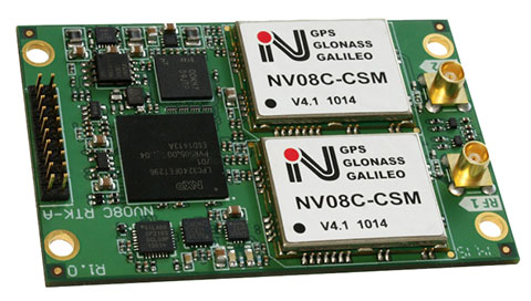
The NV08C-RTK-A is fully integrated multi-constellation L1 heading receiver with embedded real-tiime kinematic (RTK) functionality and compatibility with GPS, GLONASS, Galileo and BeiDou. The NV08C-RTK-A is designed for use in high-accuracy applications that demand low-cost, low-power consumption, a small form factor and high performance, such as construction, mining and industrial; environmental and structural monitoring; machine control; parallel driving systems; precision agriculture; UAVs; and robotics and intelligent machines.
The SLD-100 GNSS Rover accessory facilitates hydrographic measurement in bodies of water up to 100 meters in depth. it is designed for anyone who finds themselves needing to survey into bodies of water, streams and rivers. With survey-grade accuracy, the SLD-100 can be added to any brand GNSS RTK rover to allow for position and depth measurements to be made simultaneously. With a built-in 10-hour lithium battery and transmitter unit with Bluetooth connectivity, the SLD-100 provides standard-depth data streams in several industry-standard NMEA formats at 1 Hz, 4800 bps, providing compatibility with any hydrographic surveying software package. Position and depth information is externally logged on a computer or controller. Included transom mounting hardware enables easy installation.
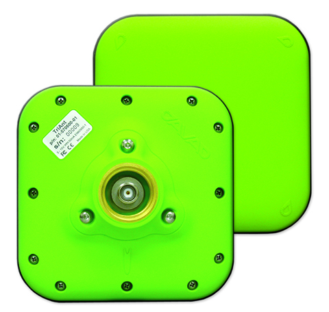
TriAnt is small, thin and rugged high-performance GNSS antenna. It measures 128 x 128 millimeters (mm) square and 39 mm thick. It can be mounted with three screws to flat surfaces. It is designed for applications such as machine control and surround anennas of the TRIUMPH-4X. The antenna cable is routed through the center of the antenna (TNC connector) for protection in harsh environments. The TriAnt can also be mounted on poles (1–14 inches thread) using its mount-pole attachment, which increases the thickness to 54.5 mm.
The X20i L1 GPS receiver by CHC Navigation is powered by a high-precision L1 GPS engine. Its integrated Bluetooth chip enables it to wirelessly collect submeter positions in real- time or centimeter post-processed on an iPhone or iPad. All location-aware apps on the iPhone and iPad are compatible with the X20i. Immediately after pairing and answering the security question allowing the X20i to take control of location services on the iOS device, 1 million iOS applications are capable of utilizing the high-accuracy data of the X20i, and become accurate to either 1 foot or 1 centimeter. Apps that can make use of the high accuracy include TerraGo Edge, ESRI’s ArcView Connector and those by CarteGraph Systems.
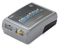
BlueStarGPS offers both GPS and GNSS options in a rugged, lightweight package. The BlueStarGPS device was designed to meet sub-meter mapping and data-collection needs in the pipeline and utility industries. It provides sub-meter precision without post-processing, and maintains accurate positioning when the SBAS signal is obstructed. This means it can function under trees, around buildings and in rugged terrain where other receivers can fail. The BlueStarGPS is designed specifically for use with Android mobile devices, such as smartphones, tablets or notebook computers, as well as cable and pipe “locating” tools with a connectivity range of up to 1 kilometer.
UAV measures through water surfaces of rivers, lakes
The RIEGL BathyCopter is a small-UAV-based surveying system capable of measuring through the water surface. It’s suitable for generating profiles of rivers or water reservoirs. The platform design integrates a topo-bathymetric green laser depth meter, an APX 15 inertial measurement unit (IMU)/GNSS with antenna, a control unit and a digital camera. Applications include generation of river profiles, survey of reservoirs and canals, landscaping, support of construction projects, and surveys for planning and carrying out hydraulic engineering work.
The Zenmuse X5 is a micro four-thirds (M4/3) camera designed specifically for aerial use. With a large sensor, aerial image makers will be able to capture up to 13 stops of dynamic range, enabling capture of high-resolution 16-megapixel photos or 4 k, 24 fps and 30 fps videos in complex lighting environments. It supports four interchangeable lenses. The Zenmuse X5 is designed for creation of high-quality aerial maps and 3D models, industrial and utility inspection, and professional video capture.
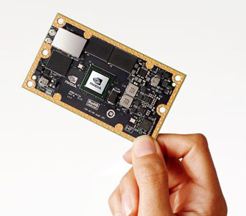
The NVIDIA Jetson TX1 module is designed to power smart devices — including drones that don’t just fly by remote control, but navigate their way through a forest for search and rescue. It is an embedded computer designed to learn to recognize objects or interpret information, incorporating capabilities such as machine learning, computer vision and navigation into a single system. This technology expands the ability of machines to operate on their own and adapt to their surroundings by recognizing images, processing conversational speech, or analyzing a room full of furniture and finding a path to navigate across it.
GPS Soure is offering the S14GT & S18GT splitters for small cell networks and distributed antenna systems (PRNewsFoto/GPS Source, Inc.)
GPS Source has released of a line of GPS/GNSS splitters created for the small-cell wireless and distributed antenna system markets. Specifically designed for the L-band frequency, they can eliminate the cost of multiple antennas and long cable runs in wireless installations.
With four or eight outputs, the new line of GPS/GNSS splitters make it possible to use a single GPS referencing antenna and cable arrangement for multiple synchronized systems. The splitters are available at a low price point and include features such as DC bias select and amplification.
GPS Source RF signal splitters typically operate in conjunction with an active GPS antenna (a GPS antenna that includes an integrated low noise amplifier). Consequently, a GPS RF signal splitter must have provisions for managing the DC voltage to the active GPS antenna. The S14GT and S18GT will power an external GPS antenna from any of the RF outputs. A “hunt-and-pick” circuit is used to select only one DC input for power should more than one source be connected. Designed for redundancy, if the selected DC bias input should fail, the DC bias will automatically switch to another DC input to ensure an uninterrupted power supply to the active antenna.
“Distributed antenna systems allow for easy system growth in size and scope of application, whether the system needs to scale to reach new service areas or add bandwidth and capacity,” said Robert Horton of GPS Source. ” This growth has led to a strong demand for cost effective solutions that support GPS synchronization, an area where we are specialists. GPS Source brings leading-edge technologies and addresses major GPS/GNSS challenges faced by carriers and system integrators.”
The S14GT and S18GT are in production and will be available January 2016. A CE Mark approval from the European Notified Body for these two devices will be available afterward.
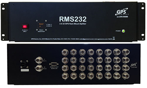
GPS Source has released a GPS/GNSS rackmount splitter with dual antenna inputs and antenna health monitoring. Developed for the wireless industry, the dual-input splitter provides a GPS timing signal to up to 32 GPS/GNSS synchronization modules and receivers. Its design ensures the GPS timing signal is always available, even in the event of an antenna or cable failure, the company said.
Like GPS Source’s GPS rackmount splitters, the new rackmount splitter amplifies and splits the GPS/GNSS signal. However, the new splitter also includes dual GPS antenna input ports, a health monitor and sensor switch. Up to 32 GPS/GNSS receivers or timing synchronization modules can access the signal at one time. Antenna redundancy is acquired through the use of primary and backup antennas. The sensor monitors the health of the primary antenna connected to the splitter. Based on the information provided by the sensor, the splitter will automatically switch antennas. The ability of the splitter to switch antennas allows all connected GPS devices to remain fully functional in the event of an antenna failure, which is important in today’s wireless environment.
“The demand for high-speed wireless internet and data network access over a wide area has grown at a record pace,” said Robert Horton, CEO of GPS Source. “This growth has led to a strong demand for solutions that support more than one function because of limited space and increased usage. The new rackmount splitters, RMS216 and RMS232, will keep multiple timing synchronization modules operating for an extended period when a GPS antenna or cable fails. This extended period gives a solution provider supporting a cell site, base station, or DAS network, the ability to identify and fix any GPS/GNSS antenna or cable problem before other challenges arise.”
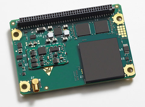
The Rockwell Collins GB-GRAM-M (pictured here) is the product of one of the MUE card development contracts, awarded by the U.S. Air Force Space and Missile Systems Center. The program is developing the next generation of GPS user equipment to include a new military signal and enhanced security architecture
GPS Source and Rockwell Collins have successfully demonstrated the ability of the Military-Code Ground-Based GPS Receiver Application Module (GB-GRAM-M) receiver card to fit within the Defense Advanced GPS Receiver (DAGR) Distributed Device (D3).
GPS Source and Rockwell Collins are the first to provide this capability for the M-code signal, which is one of the key elements in the modernization of military GPS capabilities.
The initial fit checks confirm that the Rockwell Collins GB-GRAM-M Type II receiver fits within the volume of the D3 and is able to acquire, track and navigate using C/A, Y and M-code while enclosed in the unit. Initial testing also validated backwards compatibility of the IS-GPS-153 serial port interface of the GB-GRAM-M receiver.
“These outstanding initial results confirm our confidence that the MGUE integration with the D3, when authorized to proceed, will be achieved in short order and with a very high probability of success,” said GPS Source CEO Robert Horton.
Mike Jones, vice president and general manager of Communication and Navigation Products for Rockwell Collins, added, “This demonstration paves the way for the D3 to incorporate the next-generation GPS capability that our GB-GRAM-M provides.”
GPS Source’s D3 supports new or retrofit programs integrating radio or communications equipment. It removes the burden of multiple SAASM GPS receivers or antennas. As a Selective Availability Anti-Spoofing Module GPS router, it is designed to meet the U.S. Army’s DAGR Distributed Device (D3) performance requirements, mounted into an existing DAGR vehicle mount, utilizing standard DAGR accessories.
The Rockwell Collins GB-GRAM-M is the product of one of the MUE card development contracts, awarded by the U.S. Air Force Space and Missile Systems Center. The program is developing the next generation of GPS user equipment to include a new military signal and enhanced security architecture.
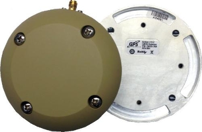
GPS Source has released a new GNSS antenna that is robust, lightweight, and suitable for harsh environments. It is designed for long-term, high-precision applications worldwide, the company said.
The antenna was engineered for the demanding aviation environment, in both commercial and military applications. Built to military standards (MIL-STD), it is impact resistant, tolerant of exposure to dust, chemicals and jet fuels, and has the ability to withstand shock and vibration.
Signal reception is unaffected by antenna placement. Designed to operate in the most extreme and demanding applications, it gives outstanding results, enabling maximum satellite reception, with ultra-low Dilution of Precision (DOP), GPS Source said.
“We are very excited about the new GNSS antenna,” said Robert Horton, CEO of GPS Source. “Our advanced technology provides superior performance in both GPS L1/L2 and GLONASS L1/L2. This is the best solution for technically demanding users.”
The antenna is available in multiple colors and with multiple connector options.
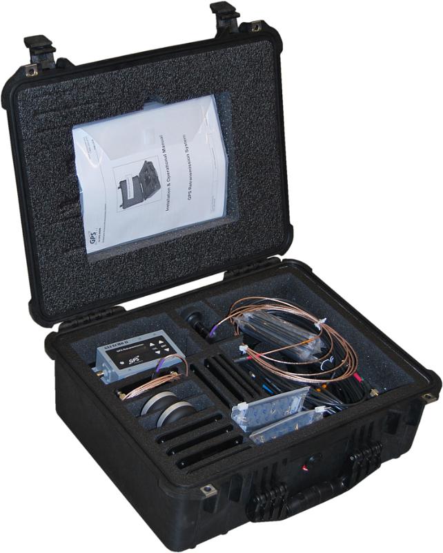
GPS Retransmission Kit by GPS Source. Photo: GPS Source
GPS Source has received a $7.5 million order for its GLI-COTTONMOUTH GPS retransmission kit from an international customer with an armored vehicle application. The kits will be used to provide armored vehicles with improved situational awareness. Shipments for the order are expected to be complete in the secondquarter of 2015.
“GPS Source is extremely pleased to be selected to provide the GPS retransmission solution for another one of our foreign military partners. Situational awareness, survivability and mission effectiveness are all improved by the use of GPS retransmission technology. Successful GPS Retransmission in the confined crew compartment of a military vehicle presents significant challenges, but one in which GPS Source has created the perfect solution,” said Robert Horton, CEO of GPS Source.
GLI-COTTONMOUTH is one of many GPS retransmission kits offered by GPS Source. The kits are available as permanent installs or man-portable. They provide GPS coverage within smaller military ground vehicle or aircraft. GPS receivers will experience no loss in signal coverage as they move out of a ground vehicle or exit an aircraft equipped with a tactical GPS retransmission kit from GPS Source.
GLI COTTONMOUTH and other GPS distribution solutions by GPS Source are in use by the U.S. Army and other military entities throughout the world. GPS retransmission technology developed by GPS Source is currently used by Net Warrior units aboard the Stryker, RG-33, and M1151. The technology is also used within the Canadian LAVIII and the French DGA SCORPION program.
Relevant GPS retransmission kits have received Safety of Flight Approval from the United States Air Force Mobility Command Systems Group and are used aboard the C17, C-130, CV/MV-22, CH-53 E/D/K, CH/MH-47, MH-60, HH60, and other host country aircraft.
GPS Source has received an indefinite-delivery/indefinite-quantity, firm-fixed-price contract with a maximum value of $16,613,430 for the procurement of defense advanced global positioning system receiver distributed devices (D3). The Army Contracting Command, Aberdeen Proving Ground, Md., was the contracting activity (W15P7T-13-D-C116).
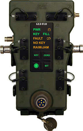
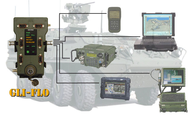
GLI-FLO was developed by the defense contract engineering firm, GPS Source. GLI-FLO is a DAGR Distributed Device (D3) that can replace the position, navigation and timing (PNT) role currently required of the DAGR or other GB-GRAM devices inside a fixed vehicle platform. Designed as a single, secure access point to multiple devices requiring PNT data on a fixed vehicle platform, it saves space, weight and power (SWaP).
“The GLI-FLO contract award is an important milestone in GPS Source’s initiative for the defense market,” said Robert Horton, CEO of GPS Source. “Getting this award was a complicated process, but it helps fulfill our vision of continual innovation in GNSS Signal Availability, especially for the warfighter. We look forward to continuing to provide manufacturing and engineering support services to the Department of Defense.”
GPS Source announced today that GLI-FLO has been granted security approval by the U.S. Air Force Global Positioning Systems Directorate. The GPS Directorate security approval provides GPS Source with the opportunity to supply military end-users and prime contractors with a DAGR Distributed Device (D3) that meets the mandate for reliability and security, GPS Source said.
GLI-FLO is a secure (ICD-GPS-153 compliant) GPS position, navigation, and timing (PNT) distribution device. One GLI-FLO has the same capability as four DAGRs operating in a platform mounted application (eight DAGRs with custom cabling). GLI-FLO serves ICD-GPS-153 PNT data simultaneously to multiple communication or weapon systems that require GPS information. It routes PNT data while secured in the bracket now used by the DAGR, utilizing standard DAGR accessory cables. When GLI-FLO is connected to one DAGR (or as alternative option, interfaces with an internal secure GPS receiver), secure PNT data can be distributed without the integration of GB-GRAM cards to multiple devices.
GLI-FLO meets the stringent requirements for reliability and security by integrating a GPS Directorate-approved SAASM receiver (Selective Availability/Anti-Spoofing Module). SAASM is the security architecture selected by the Joint Chiefs of Staff (JCS) to provide current security functions for GPS-authorized military users.
“We understand the importance of reliable GPS/PNT data for synchronizing military operations and the need to protect against jamming and/or spoofing,” said Robert Horton, CEO of GPS Source. “We further realize the importance of protecting our national assets by designing products that fully comply with all GPS Directorate security requirements. This security approval makes it possible for our GLI-FLO to be deployed by military forces without reservation.”
In addition to the SAASM compliance, other GLI-FLO features include the ability to serve ICD-GPS-153 PNT data simultaneously to multiple communications or weapon systems that require secure GPS information. It is a significant step for GPS Source toward compliance in GPS Signal Distribution (Single PNT Distribution Point). With zero impact to subscriber application software/hardware, it removes the need to rely on multiple, expensive GB-GRAMS found in military platforms.
GPS Source, Inc., has released the latest addition to its military product line, a military qualified, in-line GPS amplifier, MA11M.
The MA11M is a military-grade device used to strengthen the signal and reach of GPS. It is designed for GPS conditions where there is a weak signal. This amplifier is designed to work with an external, active antenna, and is primarily for use by military applications (both ground and air) around the world.
“GPS Source realizes the importance of protecting our national assets by designing products that can handle rigorous military environmental demands,” said Robert Horton, CEO of GPS Source. “This amplifier has been qualified for temperature, altitude, explosive atmosphere, humidity, vibration, among many other challenging conditions. The qualifications allow the military to use this device without reservation. Test summaries (MIL-STD-810 and EMI) are available upon request.”
The ruggedized MA11M GPS amplifier is designed with the thin link margins of satellite navigation systems in mind, and is a single-stage gain block that covers the GPS, Galileo, and GLONASS frequencies. The device features 30 dB of gain and excellent gain flatness of less than 1 dB.