As George Bernard Shaw said, “Progress is impossible without change.” Our industry is a great example of that. We have grown from a single GPS service to multiple GNSS constellations, to today’s increasing integration of GNSS solutions with other positioning, navigation and timing (PNT) technologies.
Since its founding 30 years ago, GPS World also has been constantly adapting and advancing so we can better report on, and help shape, our brilliant GNSS/PNT industry.
GPS World now includes expanded coverage of PNT solutions and related integration trends. We also dive deeper into GNSS/PNT developments through Q&As with leading industry suppliers, and we deliver more leading-edge application stories in high demand by our readers.
Other recent changes at GPS World revolve around our editorial staff. This month, we say goodbye to Alan Cameron, our editor-at-large, who served our media brand for 19 years. We wish Alan well.
“Our commitment to delivering timely, accurate, insightful GNSS/PNT intel has never wavered.”
Matteo and Sofranec. (Photos: GPS World)
Please join us in welcoming Diane Sofranec as GPS World’s staff editor. Diane brings with her more than 30 years of experience writing and editing content for business-to-business magazines and digital media. GPS World also is excited to welcome Matteo Luccio as a regular contributing editor.
Luccio possesses almost 20 years of experience as a writer and editor for GNSS and geospatial technology media. Luccio began his career in the industry in 2000, serving as managing editor of GPS World and Galileo’s World, then as editor of Earth Observation Magazine and GIS Monitor. Luccio earned a master’s degree from the Massachusetts Institute of Technology.
In 2020, Luccio will pen GPS World cover stories detailing trends and new solutions in receivers, antennas, simulators and PNT technologies, as well as monthly secondary features on wide-ranging topics.
During the evolution of GPS World over the past 30 years, one thing has remained constant: Our commitment to delivering timely, accurate, insightful GNSS/PNT intel has never wavered. Our stable of staff editors and regular contributors collectively possesses 200 years of GNSS/PNT experience, and our audited audience reach tops 237,000 across all media platforms.
We’re excited to continue to serve you, our family of loyal readers and marketing partners, for decades to come. Together, we remain committed to advancing our knowledge, organizations, profession and world.
Early polling results are in, and trends have emerged. Don’t absent yourself from this exercise in democracy. Make your views known on the state of the PNT industry before it’s too late — July 4 will be too late — and earn a chance at a $100 gift card.
With such questions as “Is your organization taking steps to ensure continuity of PNT availability in the event of a disruption in GNSS service?” and “What is the biggest challenge for the UAV industry?,” the survey takes the pulse of engineers, executives, designers, integrators, product managers and more across the industry. We’re looking to the horizon, seeking to identify the challenges that will guide us all into the next Big Thing.
Go to the 2019 State of the Industry Survey page and answer just slightly over 20 questions. Not only will you help create the future, you’ll help create your own chance at wealth. All who wish will be entered in a random drawing for two $100 gift cards.
I’m impressed, as always, by the engagement of our webinar audience. Questions are pouring in about the speakers’ presentations, in addition to knowledgable queries submitted before the webinar began. These events strike me as, hour for hour, the best professional education one can get, short of leaving the office for a week to attend ION GNSS+ or the institute’s other conferences through the year, or the European Navigation Conference or Intergeo or others of the like. And a webinar takes only an hour of your time! From the comfort of your desk! Or sofa, even.
Here are some of the questions posed, and brief digests of our experts’ answers. The panel included John Fischer, VP Advanced R&D at Orolia, assisted by Jon Sinden, product manager for Rugged PNT; Tim Erbes, CTO at Talen-X; and Carol Politi, CEO at TRX Systems.
Q: Role of Galileo Public Regulated Service (PRS) in GPS-disrupted environment? Particularly given NATO alliance and cooperation? Any more detail about use of other GNSS to make solution more robust?
A: The PRS is certainly low-hanging fruit for traditional partners to take advantage of both GPS and Galileo, and I imagine fielded solutions will soon start to show that. There are substantial benefits to be gained from use of other GNSS as well.
Q: Please discuss the hardened military aspects of coming GPS III signals and codes. How will the new GPS III constellation impact your products?
A: Block III alone is not enough to make this happen. A new M-code will eventually replace the SAASM M-code, and it will provide a true separation from the civilian signal, different from the current situation with M-code and C/A code. Already, a dozen or more IIF satellites are now transmitting it. But the upgrade has to happen in three places for it to become effective: the satellites, the user receiver — and this is a complex, extremely broad and varied picture in the military realm — and finally the ground control system. There have been some difficulties in deploying the new OCX. This is the biggest determining factor of when these new features will roll out.
Q: What is the potential role of other means of PNT: eLoran, Iridium STL, lidar, and so on?
A: ELoran a very good alternative, ideal from the point of view of diversity: terrestrial instead of satellite, high-power instead of low, other end of spectrum from GNSS. Orolia published a white paper on a holistic approach towards resilient PNT, discussing eLoran and STL; see our website.
There are additional opportunities for outside-the-box solutions, for example, the sensors aboard tanks for anti-missile defense systems. They could also be used for PNT. Networked data radios for crowdsourced PNT data.
In our redesign of the GPS World website, which coincided with our magazine redesign in November 2015, we endeavored to make the website even easier to use. Part of that effort consolidated some of our most popular features under the More dropdown menu. The little word appears at the far right of the menu row under our logo. Within it is a world of data and information to explore.
For those seeking current and historical data on the satellites in the various GNSS constellations, we have a full Almanac, which we update at least twice a year for the print magazine. If you want to stay on top of Upcoming GNSS Satellites Launches, we provide a handy table that is updated frequently by the one and only Richard Langley, our GNSS guru. Richard also oversees the numerous and informative Innovation columns, all of which are available under the Innovation tab — right there under More.
Our most current issue can be accessed through the words Digital Edition at the bottom of the page. Or, again under More, go to Magazine Archive for a full collection of every digital issue that reaches back a decade to 2005.
Other great resources under More are our annual Receiver Survey and Antenna Survey. Both of these products are time intensive to produce, pulling together data and specs from almost 100 companies in an effort to provide a full picture of the products available and their capabilities.
Similarly, the Buyers Guide link will take you to a special section on our website, allowing you to search manufacturers by product category and subcategory. Our next major update of the Buyers Guide will appear in print in June, but our gathering of the data now takes place year round as companies sign up to take part. If your company isn’t in our Buyers Guide, click on the “Add My Listing” link in the top right corner of the Buyers Guide page.
GPS to the power of PNT. Or, as I like to think of it, GPSPNT.
We are rapidly entering — or we have already entered — the era in which we say “GPS” but we really mean so much more.
We mean GNSS: GPS + GLONASS + Galileo + BeiDou.
We mean all of the above plus satellite-based augmentation systems (SBAS), now encompassing WAAS, EGNOS, SDCM, QZSS, IRNSS, and I don’t think we’re done yet.
We mean all the above plus several private-sector corrections services, including but not limited to OmniStar, StarFire, Veripos, Fugro, Terrastar, Atlas, and surely more to come.
We mean all of the above plus back-ups in the event of jamming or other interference: eLoran is a prime candidate, and there are others.
We mean all of the above plus many technologies that can be integrated — are being integrated — with GPS/GNSS to achieve a seamless position, navigation and timing (PNT) solution: inertial and other MEMS, cell ID, Wi-Fi, Bluetooth, DSRC, FM and UHF, and many more. Think of a band of the RF spectrum (or even non-RF technology as the mentioned inertial/MEMS); it’s probably on that list or soon will be.
We mean all of the above plus many forms of software that go into making up a geographic information systems (GIS) backbone, a map-matching system, a building information model (BIM) or other application and extension of the GPS data.
They all work together. They all need each other. But they all begin with GPS. Sometime tomorrow, they will all begin with GNSS. Today, GPS is the game in town.
Saying “we mean,” I denote “we” in the loose or editorial sense: this magazine. We treat all of the technologies as ways to get to the solution: the ubiquitous, seamless PNT solution. We’ve been wondering recently if the umbrella has grown too wide for “GPS” to continue to be its label.
No matter how professionally and technically correct both you and we aim to be by employing the terms GNSS, PNT and integrated positioning technologies as appropriate, the world at large probably will continue to call all of the above “GPS.” And the label remains the easiest shorthand for all of the above. That is one of the reasons we have decided to continue calling this great magazine GPS World.
But we really mean so much more, and the pages that follow this one, and will follow in months to come, bring you so much more — fulfilling the promise of the “kicker” in our new name: GNSS, Position, Navigation, and Timing.
The Institute of Navigation (ION) GNSS+ conference is scheduled for Sept. 14-18 this year, just down the road in Tampa, Fla. It’s just over an hour’s drive for me, so I’ll be there again this year.
The reminders from ION have started to show up in my inbox, touting issues like PNT privacy, a new UAV session, a return of the popular indoor navigation demonstrations with a significantly larger group of companies demonstrating, an update on what’s happening in indoor navigation regulation-land, and with a number ways to find out what’s happening on social media. So most GNSS industry people will now have their reminder to register, get a hotel room and choose the sessions they want to attend for their week in Tampa.
GPS World will be there as usual with our full team, including our market-sector editors, along with near-real-time coverage of the show on GPSworld.com and on Twitter. The exhibition floor looks to be almost full, so if you were sitting on the fence thinking about exhibiting, its probably time to make a decision — there only appear to be a few booths still open.
GPS World will also video record the indoor navigation demonstrations, and portions will be posted online at the GPS World YouTubechannel.
Also, come by the GPS World booth during the exhibit hall reception Wednesday evening to film a video-selfie with Mary Ann, our August cover great white shark. The video-selfies give you 30 seconds to tell us about yourself, and will be posted to our YouTube channel.
The CGSIC (Civil GPS Service Interface Committee) meets and tutorials will be held on Monday and Tuesday, but the week basically gets going with the plenary session on Tuesday evening.
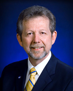
James L. Green, director of Planetary Science for NASA.
This year, ION has called on Dr. James L. Green, director, Planetary Science at NASA, to give an insight into NASA’s interplanetary exploration over the last several years. He plans to take us “on a journey navigating our way through the Solar System showing you new worlds and new discoveries through the eyes of our planetary spacecraft.” In the last several years alone, the understanding of the origin and evolution of the solar system has changed dramatically. He’ll demonstrate how our foundations of knowledge have literally been reestablished.
Technical papers and applications sessions get rolling bright and early on Tuesday morning.
Then the exhibit hall opens up at 10 a.m. on Wednesday, with more than 50 GNSS and related exhibitors from around the world showing their new products and innovations. Exhibitors range from GNSS systems manufacturers to simulation, timing, engineering and system integrators, chip and receiver manufacturers, antenna and RF component suppliers, test-solution suppliers, indoor location experts, inertial navigation companies, government and R&D agencies, military and commercial GNSS suppliers, satellite system and component providers, survey-systems suppliers, and a smattering of Internet of Things (IoT) proponents. The exhibit floor runs Tuesday through Thursday in parallel with the applications presentations and panels and technical papers.
The show floor at ION-GNSS 2014.
Key application presentations for me to catch include the indoor location demonstrations on Wednesday afternoon, and the new UAV navigation session on Thursday morning. But there are around four parallel presentations on systems and applications and four sessions of technical papers each morning and afternoon Tuesday through Friday, so there are enough topics on a huge range of GNSS and related navigation technologies that would satisfy almost anyone in the industry or anyone wanting to learn about the industry.
Indoor Location Demonstration
The list of vendors who plan to demonstrate at the indoor location demonstration session is lengthy:
Nokia
InvenSense
RX Networks
Indoor.rs
Samsung
CSR
Combain
Pole Star
ByteLight
Microsoft
That’s about twice as many participants as last year, when the audience was treated to a number of demos that worked, and some which basically didn’t. So, this is an opportunity to redeem themselves for those who had problems, time to update and show improvements over last year for the ones who demonstrated successful indoor navigation, and for the newcomers, we shall see what they have to offer. Hopefully, companies will have recognized that it’s essential to a have a large-screen display replicating handhelds for a large audience to follow what’s going on.
UAV Session
The UAV session appears to concentrate on alternate navigation and other sensors for unmanned airborne vehicles. Papers include modeling and calibration to remove magnetic biases coming from other devices on the platform; a kind of indoor navigation for micro-UAVs entering buildings for assistance in disaster conditions; navigation using optical imaging with and without GNSS; Stanford’s JAGER jammer detection project using DME and ADS-B signal navigation; and integrity requirements for UAV sense-and-avoid systems. Another panel session on Friday discusses integration of UAVs into the U.S. National Airspace System.
If these couple of topics don’t fire you with enthusiasm, don’t worry – there are masses of other great topics to pick from in the extensive technical program at ION GNSS+. Right now, pre-registration for ION GNSS+ is running 26 percent ahead of where it was last year, so we could have 1,300-1,400 technical attendees this year.
So, come on down to Florida – yes, it’s warm (the Convention Center is air conditioned), but its not too warm — even for a guy like me from the frozen North!
 As George Bernard Shaw said, “Progress is impossible without change.” Our industry is a great example of that. We have grown from a single GPS service to multiple GNSS constellations, to today’s increasing integration of GNSS solutions with other positioning, navigation and timing (PNT) technologies.