SPH Engineering is offering two new ground-penetrating radar systems optimized for UAV integration: MALÅ GeoDrone 600 and Zond Aero 600 NG.
Both 600 MHz antennas significantly enhance high-resolution subsurface investigations with drones, supporting applications in engineering surveys, utility mapping, archaeology, environmental studies and geophysical research. They enable surveyors to capture consistent, high-quality subsurface data in areas difficult, slow, or unsafe to access with traditional ground instruments.
Operating at 600 MHz, the antennas offer a balance between penetration depth and fine near-surface resolution. Typical penetration from the drone is up to 2 meters, depending on the surface conditions, while SPH Engineering’s True Terrain Following ensures stable antenna height to maintain data quality and repeatability.
Compared to ground-based carts or vehicle systems, the UAV-borne configuration enables operators to:
Survey rocky, uneven, vegetated, or steep terrain
Achieve consistent grid spacing and uniform antenna coupling
Cover large areas significantly faster than manual GPR methods
Improve safety by reducing personnel exposure in risky field conditions
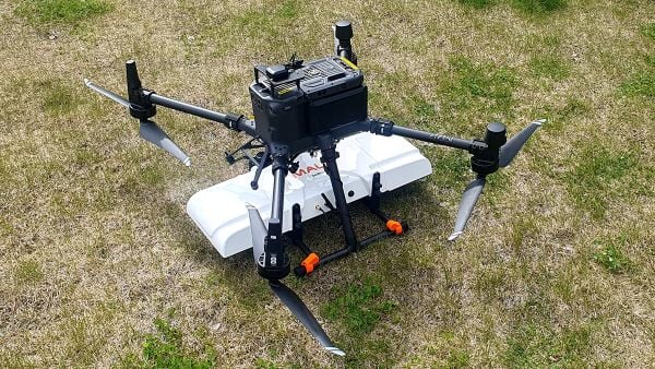
The MALÅ GeoDrone 600 combines the reliability of MALÅ instrumentation with SPH Engineering’s fully integrated drone workflow. Designed for precision engineering, utility detection, and geophysical mapping, the antenna produces clear, high-quality radargrams suitable for detailed structural assessment and shallow subsurface characterization.
Key Specifications
Central frequency: 600 MHz
Operating Bandwidth: 250-900 MHz
Typical penetration: up to 2 m (soil-dependent)
Sampling: MALÅ HDR technology
Antenna design: Shielded
Weight: 2.7 kg
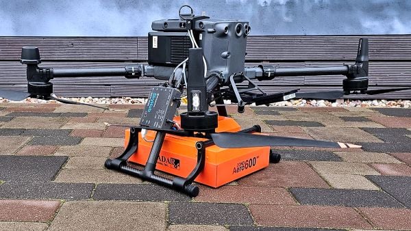
The Zond Aero 600 NG antenna package. (Photo: SPH Engineering)
The Zond Aero 600 NG is a next-generation shielded antenna designed specifically for airborne GPR operations. It offers a strong signal-to-noise ratio, improved ground coupling at low altitudes, and robust performance over natural terrain, making it particularly suitable for geophysical research, archaeology and environmental geoscience.
Key Specifications
Central frequency: 600 MHz
Operating Bandwidth: 300-950 MHz (-12 dB)
Typical penetration: up to 2 m (soil-dependent)
Sampling: Real-Time Sampling (RTS) with high hardware stacking
Antenna type: Shielded
Weight: 1.7 kg
Both antennas are fully compatible with SPH Engineering’s UgCS flight planning software and the SkyHub drone onboard computer, enabling:
Automated terrain-following flights over complex topography
Precise altitude control for optimal GPR signal geometry
Synchronized GNSS + radar trace logging (for Zond Aero 600, MALÅ GeoDrone 600 has built-in data recorder).
“The tasks of paleontologists and classical historians and archaeologists are remarkably similar — to excavate, decipher and bring to life the tantalizing remnants of a time we will never see.” — Adrienne Mayor
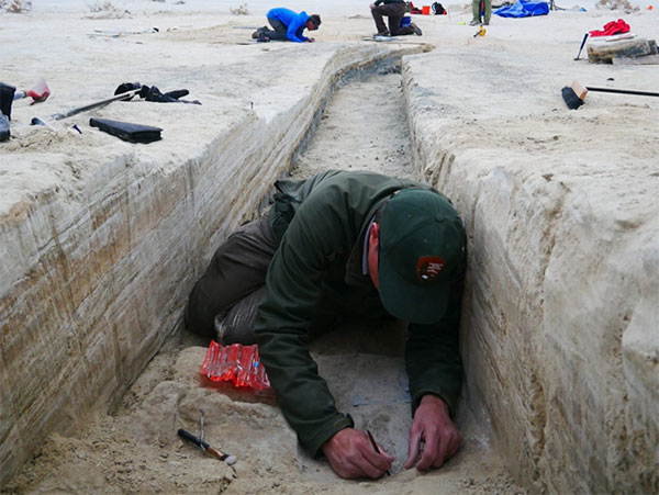
Heatwaves rose up from the dusty, dry, cracked ground. Tiny black flies buzzed around the team’s eyes and faces. The only shade was under a canopy erected across the shallow open trench where half a dozen people gently brushed away the layers. Dirt is time; the deeper one digs, the further back in time one goes.
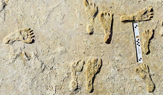
A layer 23,000 years old is exposed at nearly two feet down, revealing footprints of a female and a toddler. It tells a story of her mile-long journey through the soft clay mud. Roaming nearby was a giant sloth and a herd of mammoths. This discovery forces science to re-adjust the timeline of humans living on the North American continent, pushing it further back into the Pleistocene era at least 10,000 years.
Discoveries like this are the treasures archeologists seek. Archaeologists are scientists — part treasure hunters and part storytellers. They add context to history.
A trench dug into the brown gypsum soil on a lake playa in White Sands National Park reveals more human footprints below the surface. (Photo: National Park Service)
Ground-Penetrating Radar
Advanced technologies are aiding new discoveries of the past. Even though the footprints were buried beneath two feet of dirt, they were discovered without physically seeing them. Ground-penetrating radar (GPR) made the discovery possible. GPR has made significant advancements in recent years, along with improvements in other types of remote sensing applications.
The resolution of GPR has improved along with the depths that GPR can detect objects. Computers can process the GPR data into 3D images providing a depth profile of the scanned area. This is how the footprints were detected.
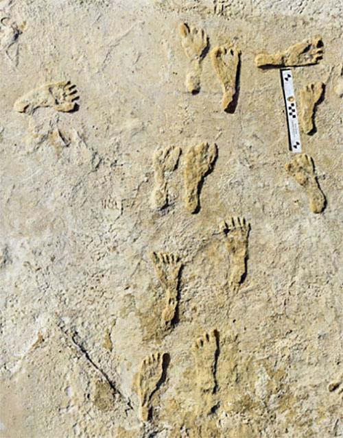
White Sands has the largest collection of fossilized human footprints. (Photo: National Park Service)
In addition to GPR, the researchers used magnetometers that verify disturbances in the sediment, which can also be imaged in 3D, albeit with a much lower resolution.
“The sediment itself has a memory that records the effects of the animal’s weight and momentum in a beautiful way. It gives us a way to understand the biomechanics of extinct fauna that we never had before,” said Thomas Urban, the Cornell University research scientist who led the team making the discovery.
Usually, archeological findings are of bones and artifacts. Fossilized “ghost” footprints of humans and other creatures brings them to life, providing glimpses of the living past.
Under ideal conditions, GPR can reach depths of 30 meters (98 feet). The accuracy and range of GPR depend on sediment type, moisture content and other geologic morphologies. Underlying GPR technology and magnetometry are robust geospatial information systems (GIS) that preserve a digital record of the discovery, allowing for further geospatial analyses. Advances in machine learning will improve future detection.
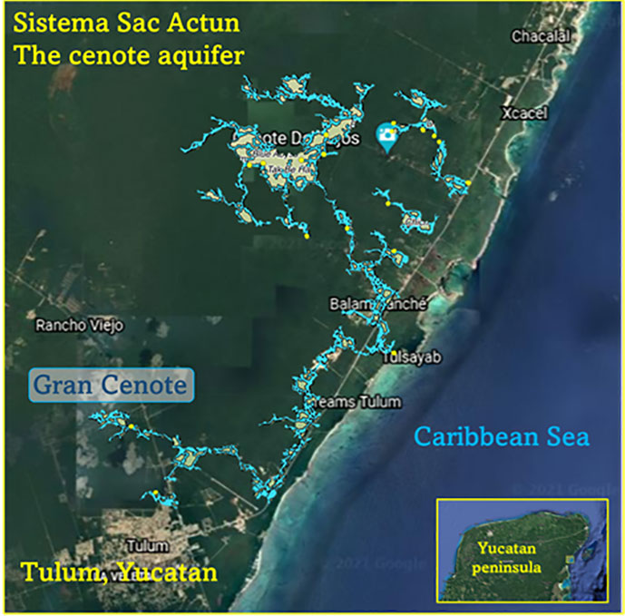
Elsewhere in the Americas, a project has been ongoing in Mexico since the 1990s using GPR to map the cenotes and underground aquifers used by the Mayans. A 215-mile-long underground water cave system — the longest in the world — has been mapped in the Yucatan peninsula. Divers exploring these cenotes found remains of Ice Age animals, including a sabertooth tigers and mammoths.
Map: William Tewelow
Lidar and ALS
Lidar (light detection and ranging) is making even more discoveries possible with the help of artificial intelligence and machine learning. For instance, in the jungles of Guatemala, lidar revealed the unknown ancient Mayan city of Tikal.
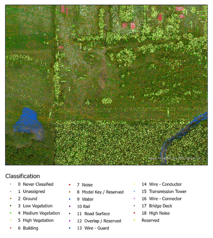
Lidar is an active sensor that measures ground height. Using an airborne laser scanning (ALS) system mounted to a plane, helicopter or UAV, the lidar device’s laser beams scan the landscape. The system calculates the time it takes for the beam to reach an object on the ground and bounce back.
The result generates one point for each ground object the laser touches, calculating the distance the beam traveled. Billions of points are collected during a scan. Geospatial archeologists then process the collected points into a point cloud (Figure 1). Selecting only points classified as ground and water, the points are converted to a raster image, and archeologists are provided a perspective of the bare earth under tree canopy and vegetation (Figure 2).
In this way, lidar serves as a non-destructive way to identify earthwork formations, even in dense jungle.
Figure 2. Lidar points are converted to a raster providing a bare-earth representation of the landscape. (Image: Stephanie Clark)
Figure 3. Pixel-derived object-based classification, developed using machine learning, identifies unmarked headstones from UAV-collected imagery. (Image: Stephanie Clark)
Object-Based Imagery Analysis
The challenge with lidar and imagery is the sheer volume of data, beyond the scope of what a human can manually review. Because of how faint archaeological features can be, the search often requires manipulating imagery datasets by combining multispectral bands, and then merging them with topographical data. To assist this huge endeavor, artificial intelligence is applied to pixel-based classification and object-based imagery analysis (OBIA) to highlight areas of interest for further study.
Dylan Davis, a Ph.D. candidate at Pennsylvania State University, spearheaded the use of OBIA for finding earthworks such as circular mounds, stone walls,and roadways in Beaufort, South Carolina. He took advantage of high-resolution NOAA imagery taken of the coast before the hurricane season of 2008. Using artificial intelligence for object-based imagery analysis, 160 previously undetected mound features were found.
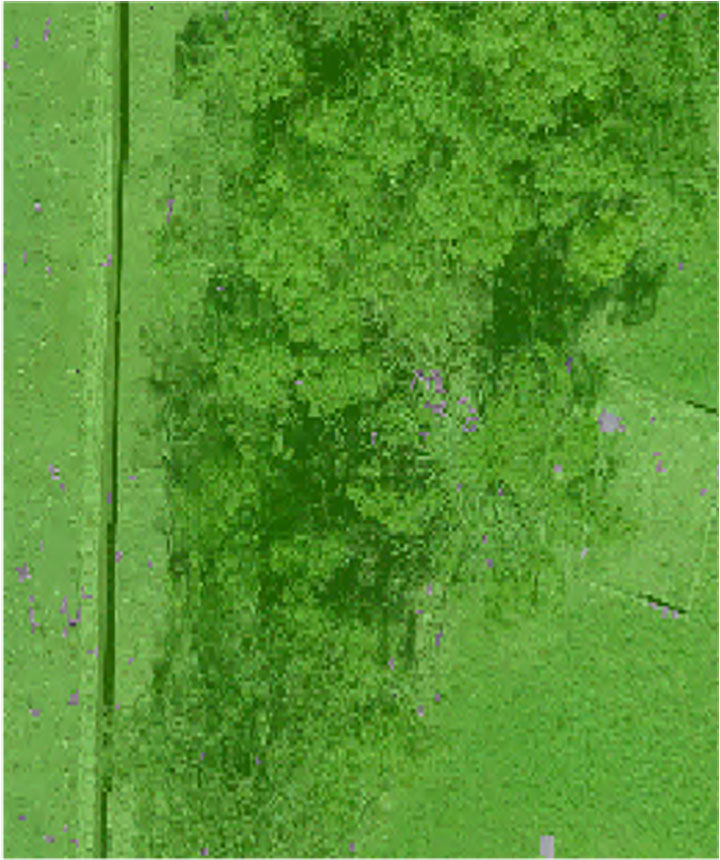
Raster comparison: Sea Pines Shell Ring, Hilton Head Island, South Carolina. Credit: Dylan S. Davis, Matthew C. Sanger & Carl P. Lipo (2018): “Automated mound detection using lidar and object-based image analysis in Beaufort County, South Carolina,” Southeastern Archaeology [https://doi.org/10.1080/0734578X.2018.1482186]On the local level, archeologists apply the same approach to finding headstones in unmarked cemeteries. A pixel-defined object-based classification system helped one researcher automatically identify potential headstones in a densely vegetated cemetery.
The technology used for OBIA is also used for visual-inertial odometry (VIO). NASA is experimenting with VIO techniques to help astronauts navigate the lunar surface (see NASA’s Artemis program will need lunar spatial reference system). For Artemis, VIO will use the Moon’s craters as a reference system to derive an accurate position.
Virtual 3D Worlds
Perhaps one of the most significant uses of technology for archaeological research and exploration is the use of virtual 3D immersive worlds. Exploring ancient worlds as they might have looked gives archaeologists additional insights and the public a chance to experience their discoveries, connecting us with history.
The mile-long journey of a young female carrying a toddler across an Ice Age landscape 23,000 years ago seems so distant, yet so familiar to any parent. The image breathes life into our common ancestry. Through the power of GIS and modern technologies, she walked right into the 21st century.
“The man who knows and dwells in history adds a new dimension to his existence…He lives in all time; the ages are his, all live alike to him.” — William Flinders Petrie
Special thanks to Stephanie Clark, a geospatial archeologist with Integrated Environmental Solutions, LLC, of Phenix City, Alabama. Stephanie provided technical advice and collaboration, and the lidar studies for Figures 1, 2 and 3.
William Tewelow is a senior aeronautical information specialist for the Federal Aviation Administration. He is a 2016 graduate of the FAA’s management fellowship Program for Emerging Leaders and a mentor with the FAA’s National Mentor Program. He served on special assignment to the U.S. Department of Transportation and led a national strategic geospatial initiative under the authority of the White House Open Data Partnership.
Tewelow is a designated Geographic Information Systems Professionals (GISP), with degrees in geographic information technology and Intelligence Studies. he is currently earning his master’s degree in organizational leadership with a focus on performance management.
Tewelow retired from the U.S. Navy after serving 23 years as a geospatial and imagery intelligence specialist, a naval aviator, a meteorologist and a tactical oceanographer earning three achievement medals. He was among the first in the nation to earn a Geospatial Specialist Certification from the U.S. Department of Labor while working at NASA Stennis Space Center. He is married, enjoys traveling, connecting people, and solving problems, and is interested in new technology. His favorite quote is, “A man’s mind changed by a new idea can never go back to its original dimension.” ~ Oliver Wendell Holmes
A team deployed ground-penetrating radar mounted on drones, showing that the technology can search and locate targets buried deep in glacial ice.
On July 15, 1942, six P-38 Lightning fighter aircraft and two B-17 Flying Fortress bombers encountered a blizzard while supporting the Allied war effort in the British Isles.
The aircraft were forced to conduct an emergency landing on the glaciers of Greenland, and though all the crew members were rescued nine days later, the aircraft were left behind.
After using radar to find areas of interest in 2011, an expedition led by the non-profit Arctic Hot Point Solutions returned to Greenland.
Ground-penetrating radar was integrated with a drone for the survey mission in Greenland. (Photo: Arctic Hotpoint Solutions)
This time, the team deployed ground-penetrating radar mounted on drones, and showed that the technology can search and locate targets buried deep in glacial ice. Aerial surveying was more effective and less risky than working on the ice.
The team extracted hydraulic fluid from 340 feet below the surface, leading to the identification of the buried aircraft as the P-38 Echo piloted by Robert Wilson.
Six undiscovered aircraft — also part of the “Lost Squadron” — remain entombed in shifting glaciers, along with many additional WWII aircraft that went down over of Greenland as they flew between the United States and the European theater.
A future expedition will attempt to excavate Echo, and locate other aircraft of the Lost Squadron.
Leica Geosystems has released its new DX Office Vision utility post processing software for mapping ground-penetrating radar (GPR) data from the field into a CAD drawing.
DX Office Vision allows even non-experienced users to obtain professional 3D CAD drawings and visualize the detected underground utilities in a simple way, according to Leica. The intuitive interface enables users to filter, select, identify and make annotations of the located targets. With DX Office Vision, post-processing for all ground-penetrating data requires no add-on or third party software.
“Following the demo of the new DX Office Vision I have to say I am impressed. The user interface is very intuitive with key processing views easily manipulated for fast interpretation of ground penetration radar data. I was particularly impressed with the DX Office Vision feature that allowed me to clean up the scan and highlight certain areas to give a clearer view of hyperbolae,” said Alex Rampton, surveyor at Plowman Craven.
DX Office Vision was developed by utility surveyors who know what is needed from a post processing software. The software was created to reduce the post processing time and eliminate all unnecessary steps to convert data or chose parameters. The software guides the user to create a reliable 3D map of the underground detected utilities with minimal training.
“DX Office Vision aims to make interpretation of GPR data easy to master for constructors and surveyors who are not familiar with how to interpret it,” said Tughan Telatar, product manager, Construction Tools for Leica Geosystems. “DX Office Vision is so simple to learn that anyone from the crew can take over data processing into professional CAD drawings in five steps and 50 per cent faster than traditional methods.”
![<b>Raster comparison: Sea Pines Shell Ring, Hilton Head Island, South Carolina. </b>Credit: Dylan S. Davis, Matthew C. Sanger & Carl P. Lipo (2018): Automated mound detection using lidar and object-based image analysis in Beaufort County, South Carolina, Southeastern Archaeology [https://doi.org/10.1080/0734578X.2018.1482186]](https://stage.globalpositioningnews.com/wp-content/uploads/2021/11/Davis-SC-mounds-HiltonHead.jpg)