Tag: Hamburg

  • Beagle Systems launches first station in country-wide drone network

    Beagle Systems launches first station in country-wide drone network

    Photo: Beagle
    Photo: Beagle

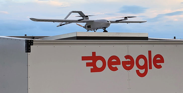
    Hamburg-based start-up Beagle Systems has begun building a nationwide network of landing and charging stations for drones.

    In Hanstedt (Lüneburger Heide) in the Lower Saxony region of Germany, the first hangar has been set up with an unmanned aerial system (UAS). From there, every surrounding place in Lower Saxony can be reached in a short time.

    The drone will be deployed from the Beagle Systems headquarters in Hamburg. Beagle Systems has the corresponding permits for flights beyond visual line of sight (BVLOS).

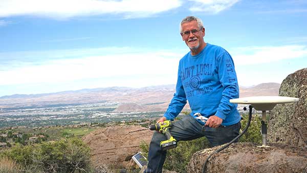
    “The start in Hanstedt is an important step for us,” said Oliver Lichtenstein, one of the three founders of Beagle Systems. “From here we can reach an area of 780,000 hectares in Lower Saxony. As the first provider of drone flights, we are thus on call within a short time at the customer’s site.”

    The drone flight can be controlled entirely from Hamburg; on-site personnel deployment is not necessary. This eliminates personnel costs as well as time spent traveling to and from the site. Because of this, Beagle Systems can carry out drone flights at a much lower cost than other providers.

    “Our goal is to build a nationwide network of charging stations within the next few years,” said Mitja Wittersheim, COO of Beagle Systems. “An EU-wide expansion is then the next step.” The expansion of the network would allow drone specialists to access a ready-to-go drone from Hamburg for customers at any location within the European Union.

    Beagle Systems is a drone-as-a-service provider specializing in long-range flights with unmanned aerial systems. The drones are already in use for the inspection and monitoring of large infrastructure facilities such as power grids.

    The company also plans to tap into the multi-billion dollar market of delivery, courier and express services. The Beagle M drone used in Hanstedt was developed in-house. It has a wingspan of 2.50 meters and can transport a load of up to three kilograms.

  • Seen & Heard: Speed traps and rescuing koalas

    Seen & Heard: Speed traps and rescuing koalas

    “Seen & Heard” is a monthly feature of GPS World magazine, traveling the world to capture interesting and unusual news stories involving the GNSS/PNT industry. 


    Photo: Drazen Zigic/iStock/Getty Images/Getty Images Plus
    Photo: Drazen Zigic/iStock/Getty Images/Getty Images Plus

    Where’s the Beef?

    A new mapping app is helping Los Angeles County residents find more than 2,000 food resources, during and after the COVID-19 pandemic. Sponsored by the non-profit 211 LA County, the LA FoodFinder is powered by Slingshot Earth, which aggregates food resources and service data from multiple public and private sources. The app enables residents to find resources for child nutrition, meal services, groceries/food pantries, senior food needs and government food benefits programs. Since the COVID-19 outbreak, 211 LA County has experienced a 10-fold increase in website traffic for food needs.


    Photo: Symbiont/iStock/Getty Images Plus
    Photo: Symbiont/iStock/Getty Images Plus

    Use that app in Germany? No Waze!

    The German government has amended its road traffic regulations to outlaw apps that alert drivers to speed cameras. The law makes it clear that any app used for traffic-monitoring alerts is forbidden, whether it runs on a phone, tablet or a GPS navigation system. Violating the traffic laws and using speed camera apps inside a car could result in a fine of up to €75 (about $83). Both Garmin and TomTom have emailed registered users alerting them to the news.


    Photo: Geoffrey Blewitt/Debra Vigil
    Photo: Geoffrey Blewitt/Debra Vigil

    Making the most of GPS data

    University of Nevada 2020 Outstanding Researcher Geoffrey Blewitt has made the most of GPS data to study changes in Earth’s crust, from the Ice Age to today. Nevada Today outlines his significant discoveries, including that GPS data may hold a key to detecting dark matter. Other discoveries: Nevada is the fastest growing state, geologically speaking, as it spreads apart. Drought in the western U.S. is causing the Sierra Nevada to lift, and the melting of ice sheets in Greenland is changing the shape of Earth.


    Photo: iStock/Getty Images Plus/Getty Images
    Photo: iStock/Getty Images Plus/Getty Images

    Koala care

    Drones equipped with FLIR thermal-imaging cameras helped save koalas injured in this summer’s Australia bushfires. In a search-and-rescue operation, Victoria wildlife experts and police used DJI Mavic 2 Enterprise Dual drones to scan the forest for injured koalas, many found clinging to scorched eucalyptus trees. The images were relayed to a ground station in a nearby van for closer inspection. When a koala was located, the experts stepped in to assess the animal, and if needed, provide healthcare and relocate it. The team used cherry pickers to retrieve the little animals.

  • Seen & Heard: Measuring Everest, GPS Rollover boo-boos

    Seen & Heard: Measuring Everest, GPS Rollover boo-boos

    Seen & Heard is a monthly feature of GPS World magazine, traveling the world to capture interesting and unusual news stories involving the GPS/GNSS industry.

    Photo: Mount Everest/Daniel Prudek/Shutterstock.com
    Photo: Mount Everest/Daniel Prudek/Shutterstock.com

    Surveying the highest height

    The precise height of Mount Everest — now listed as 29,029 feet, or 8,848 meters — has been contested since the first survey by British officers in 1849.

    On January 2020, Nepal plans to end the controversy and declare both snow and rock height of the world’s tallest mountain. This spring a two-member Nepali survey team will summit the mountain with a Trimble R10 GNSS receiver, gifted by New Zealand.

    Besides a GNSS survey at the summit, teams will conduct precise leveling, trigonometric leveling and gravity surveys. The GNSS survey will cover 285 points with 12 different observation stations, nine of which are in hills of Sankhuwasava, Bhojpur and Solukhumbu districts.

    Photo: e-Golf cars/Volkswagen
    Photo: e-Golf cars/Volkswagen

    Takin’ it to the (Hamburg) streets

    Five electric Volkswagen Golfs are now on the streets of Hamburg, Germany, being tested with Level 4 automation.

    The cars are designed to handle complex urban traffic patterns without help from drivers, although they must be ready to intervene.

    Level 5, the highest category, requires the vehicle to perform all tasks, turning every rider into a passenger.

    The cars are driving 1.9 miles (3 km) of urban roads where new signals and traffic management systems have been installed for autonomous driving.

    Boeing 787 Dreamliner Hainan airlines/aapsky/Shutterstock.com
    Boeing 787 Dreamliner Hainan airlines/aapsky/Shutterstock.com

    GPS Rollover gone wrong

    The April 6 GPS Week Number Rollover was supposed to pass without a hitch, with plenty of notice that updates might be required for legacy receivers. Instead, several systems crashed.

    In China, as many as 15 Boeing 777s and 787s were grounded pending a GPS update (the receivers gave the date as August 22, 1999.)

    In New York City, part of the wireless grid faulted, cutting information feeds to the NYPD (license plate cameras) and remote worksite communications.

    In Australia, weather balloons were grounded. In the United States, NOAA autonomous monitoring stations went offline. Fixes for all these systems are underway.