Australia-based Aptella is offering free access to its AllDayRTK high-accuracy positioning service for volunteers and organizations involved in bushfire and flood recovery efforts.
Reliable positioning aids in coordinating recovery operations, assessing damage and restoring essential infrastructure. However, extreme weather events often disrupt permanent GNSS base stations due to power outages and loss of internet connectivity.
To address this challenge, AllDayRTK has developed a Synthetic Base Station system, enabling high-accuracy positioning even when permanent bases are offline. This technology creates a virtual reference station network that ensures continuity of service in disaster-affected regions, supporting emergency response teams and volunteers where traditional infrastructure cannot.
Key Benefits:
Free access for registered volunteers and recovery organizations.
High-accuracy GNSS positioning for mapping, surveying and logistics.
Synthetic Base Station technology ensures service continuity without reliance on damaged or offline permanent bases.
“Aptella is always willing to do what we can to support volunteer services with high-accuracy positioning that assist with recovery after natural disasters and extreme weather events,” said Greg Macklin, CEO at Aptella. “Our commitment is to ensure that those on the front lines have the tools they need to rebuild communities quickly and safely.”
Precise Point Positioning (PPP) has long held promise as a standalone, high-accuracy positioning technique, but its slow convergence and complexity in ambiguity resolution have limited widespread use. Over the past decade, GNSS modernization (GPS, Galileo and BeiDou) has introduced multi-frequency, high-precision signals, enhancements that expand opportunities for precise positioning.
Yet challenges remain, especially in environments with obstructed views or fast-changing motion. High-fidelity corrections and real-time performance are critical for sectors like smart transportation, robotics and disaster response.
Further in-depth research is needed to refine PPP solutions and meet the demands of real-world, dynamic applications.
A collaborative research team from Wuhan University and affiliated institutions has published a major study in the July 2025 issue of Satellite Navigation. The team developed and validated an enhanced PPP and PPP-RTK framework using next-generation GNSS signals and satellite augmentation services.
The study evaluated the performance of BDS-3’s PPP-B2b and Galileo’s HAS services across a variety of experimental settings, revealing dramatic improvements in positioning accuracy, convergence time, and reliability.
These breakthroughs offer a practical roadmap for deploying real-time high-precision navigation at global scale.
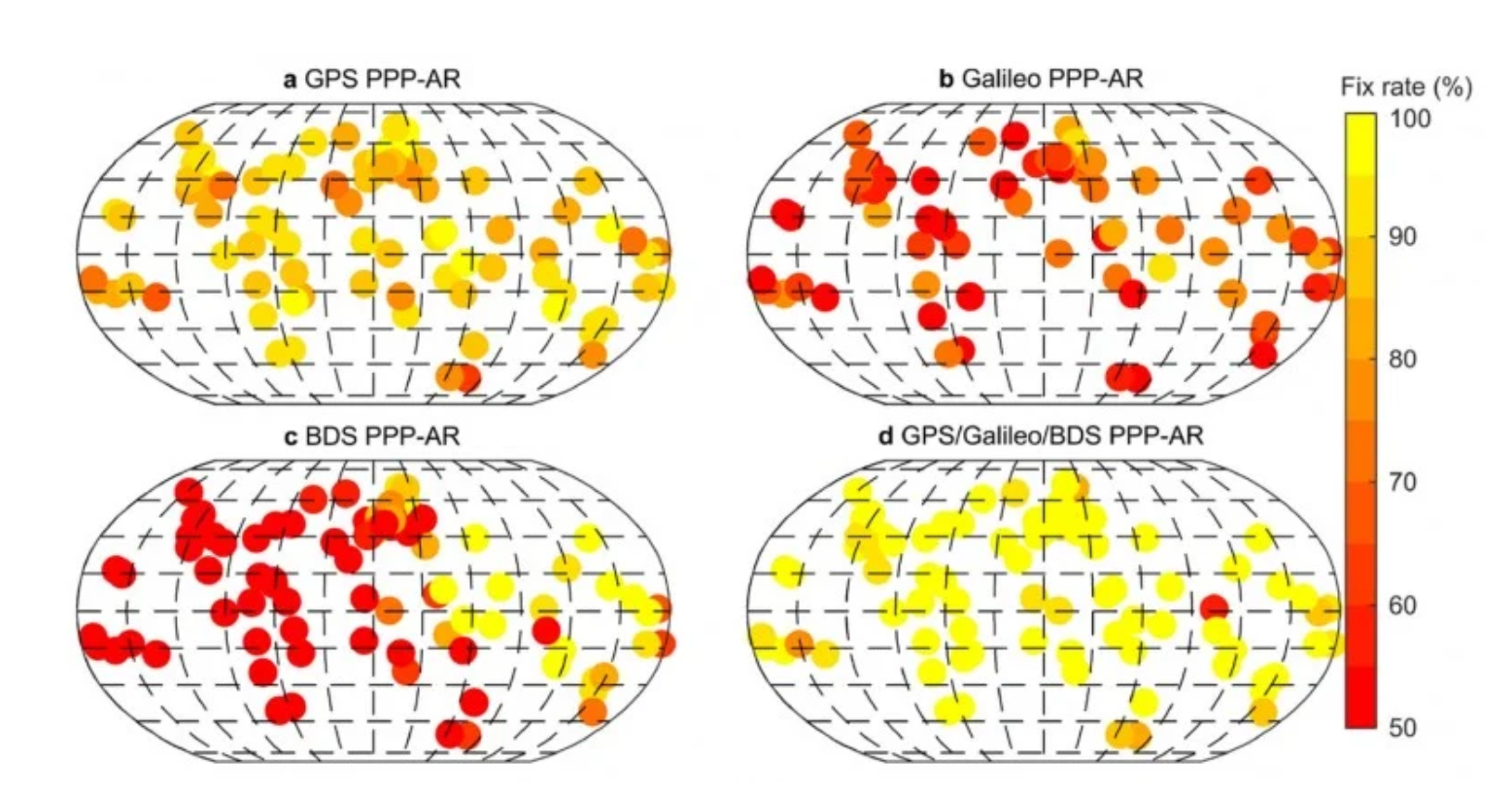
The researchers constructed an integrated precise point positioning with real-time kinematic (PPP-RTK) system incorporating real-time atmospheric corrections, observable-specific bias (OSB) products, and multi-constellation satellite data. Through extensive global experiments, they demonstrated that a combined GPS/Galileo/BeiDou configuration reduced static convergence time to under 5 minutes while achieving horizontal accuracy below 2 cm. In dynamic tests — including a real-world vehicular trial in Wuhan — PPP-RTK achieved sub-5 cm accuracy with instant or near-instant convergence, even under rapidly changing observation environments.
These systems proved especially effective when paired with atmospheric modeling techniques like Kriging and distance interpolation. With fix rates exceeding 98%, the results underscore PPP-RTK’s readiness for mission-critical applications in rapidly changing environments.
Additionally, the study evaluated augmentation services: the BeiDou PPP-B2b and Galileo High Accuracy Service (HAS). Both were found to significantly accelerate convergence (to under 15 minutes and 100 seconds, respectively) and deliver decimeter-level accuracy in kinematic scenarios.
“This study marks a turning point in the quest for real-time, high-accuracy positioning,” said Xiaodong Ren, lead author and professor at Wuhan University. “By merging advanced GNSS signals, atmospheric corrections, and real-world testing, we’ve demonstrated that PPP-RTK can deliver fast, stable and highly accurate results — even in the most demanding environments. These capabilities are essential for the next generation of autonomous systems, from self-driving cars to drones and beyond.”
The ability to achieve centimeter-level positioning accuracy quickly and without reliance on dense base station networks opens doors for a wide range of smart technologies, Xiaodong said. PPP-RTK has the potential to reshape industries such as precision agriculture, surveying, transportation logistics, and unmanned systems.
This study provides a robust framework and empirical validation for real-world adoption of high-precision GNSS applications, according to the authors. “As satellite constellations and augmentation services continue to evolve, PPP-RTK is poised to become the foundation of global positioning solutions — reliable, scalable, and ready for deployment in tomorrow’s connected world,” Xiaodong said.
In 2022, the Galileo GNSS continued to provide the world’s most precise satellite navigation information, to a user base that stands at more than 3.5 billion worldwide. Furthermore, provided services continue to improve and expand, with plans for high-accuracy positioning and signal authentication now reaching fruition.
The European Union Agency for the Space Programme (EUSPA) and the European Space Agency (ESA) continue to enjoy an effective collaboration on the many development, deployment, and evolution activities of the Galileo Programme — each according to their respective responsibilities for service provision and system development with the European Commission (EC) acting as the program manager.
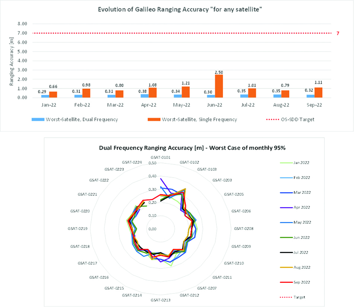
Ranging accuracy performance from January to September 2022.
Positioning-related MPLS from January to October 2022.
New Services Launched in 2022
Excellent Performance
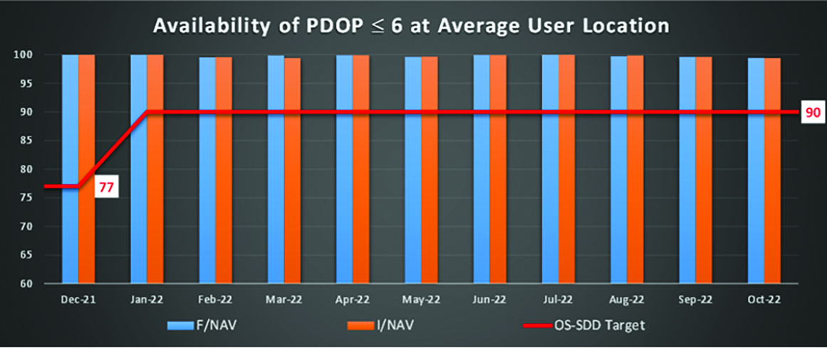
Service delivery operations and maintenance of operational systems are managed by EUSPA, which supervises many contracts that carry out the day-to-day activities from dedicated control and monitoring centers throughout Europe. In 2022, Galileo timing, navigation, and SAR/Galileo services were delivered with excellent performances that continue to exceed the formal declarations for minimum performance levels (MPL), which were increased in January, both in terms of absolute accuracy and overall service availability. The entry into service of two additional satellites in May and August, have further consolidated the overall service availability to end users.
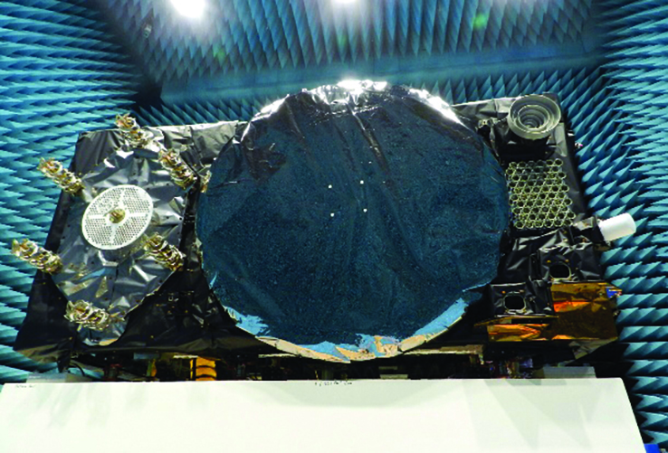
Galileo FOC Batch 3 satellite under testing.
Expansion of Service Portfolio
The service provision teams have been able to focus on improvements to, and expansion of, the service portfolio.
The I/NAV improvement will positively impact end users by enabling a faster time to first fix, and updates to the data validity status flags will lead to better protection of users against expired navigation data. These changes are implemented in updates of the onboard software of the satellites being rolled out across the constellation. At present, seven operational satellites have been successfully updated; the complete software upgrade campaign is planned to be completed this summer.
Galileo’s new High Accuracy Service will provide free precise point positioning (PPP) corrections, in the Galileo E6-B data component and by terrestrial means, for Galileo and GPS (single and multi-frequency) to achieve real-time user position improved by up to 10 times. The infrastructure to support an initial service (Phase 1) is nearing completion, and the formal declaration of the service capabilities is planned for early this year.
To provide users with a method of authenticating the received Galileo signals, especially the satellites ephemerides and the Galileo timing parameters, the new Open ServiceNavigation Message Authentication (OSNMA) service enables a receiver to confirm that a navigation message originated from the EU Galileo infrastructure. Many application areas are expected to benefit from this capability, including smart tachographs, telematics and logistics, UAVs, location-based services, and timing services. Having successfully demonstrated the technology behind the service in 2022, including a public observation phase, the roll-out of the Initial Service is planned to take place by the end of the year.
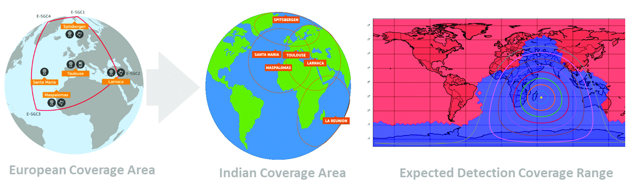
A fourth Medium Earth Orbit Local User Terminal (MEOLUT) in La Réunion will extend the SAR/Galileo Forward Link Service Coverage Area over the Indian Ocean as part of the SAR/Galileo full operational capability (FOC) declaration expected in the first quarter of 2023. The Cospas-Sarsat commissioning of this new station was completed in September 2022, and operational data is already being distributed to Cospas-Sarsat.
Reference documents for the above services can be found at the EUSPA European GNSS Service Centre website, including technical notes, interface control documents and service declaration documents.
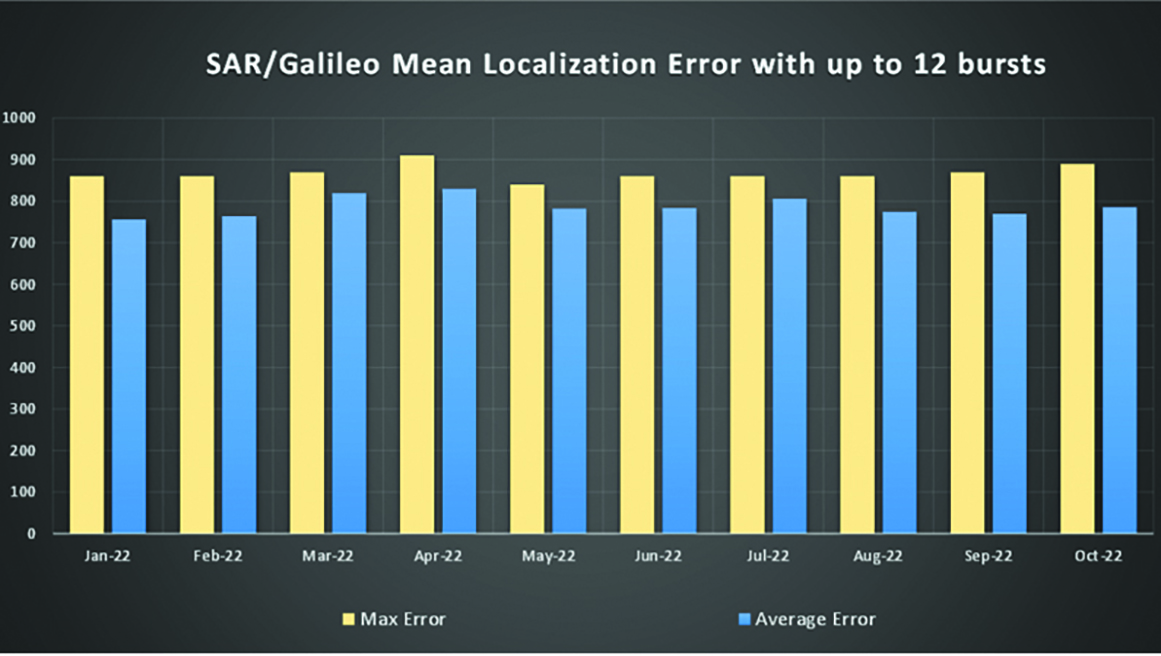
SAR/Galileo-related metrics from January to October 2022.
Extension of the SAR/Galileo Forward Link Service Coverage Area over the Indian Ocean.
FOC Infrastructure Development Nears Completion
Satellite Production
The production of the third batch of Galileo FOC satellites advanced further in 2022 with the completion of the environmental tests and the system compatibility test campaigns at the European Space Agency Test Centre in Noordwijk, The Netherlands. After 10 years of successful testing, on Oct.18, 2022, the last Galileo FOC satellite (flight model number 34) left the test center to return to the premises of the satellite manufacturer, OHB Systems, in Germany. Testing of the remaining 10 satellites has confirmed that they have been correctly built and will perform well in orbit. The acceptance review of the last couple of satellites will take place this summer.
At the beginning of 2023, the plan is to start in-orbit testing of a quasi-pilot signal on the E5 frequency using the Galileo GSAT201/202 satellites in elliptical orbit. The provision of a signal offering coarse acquisition in Galileo E5-A/GPS L5 can be a distinguishing feature for Galileo with respect to all other constellations to further improve the capability to acquire the E5 signal at low complexity. Following in-orbit testing, the strategy for roll-out of this capability will be assessed with the involvement of receiver manufacturers.
New SAR Galileo MEOLUT facility in Réunion island.
Access to Space
The discontinuation of Soyuz launch services from the Kourou Space Centre in French Guiana, because of the Russia-Ukraine conflict, has caused delays in the two Galileo launches that had been planned for 2022. The Launch 12 campaign had to be interrupted and in March 2022 the FM25 and 26 satellites were put in storage at the Kourou launch base, then returned to Europe in November.
Ariane 6 is the baseline launcher for Galileo satellites to ensure European independent access to space. The remaining Batch 3 satellites will be launched with the Ariane 62 launcher vehicle, the two strap-on solid booster variants of Ariane 6, now undergoing the final stages of development led by prime contractor Ariane Group. Ariane 6’s maiden flight is scheduled to take place in the fourth quarter of 2023.
Ground Segment
An upgrade of the ground control segment, in charge of command and control of the satellite constellation, is being developed by the industrial consortium led by GMV. The upgrades will address resolution of hardware and software obsolescence including cyber security, operability improvements, and a security monitoring overlay.
With the planned increase in the number of satellites in orbit, an additional telemetry tracking and control facility (TTCF) is being deployed in Kourou leading to seven operational TTCF stations in early 2023.
The ground mission segment, in charge of navigation control, is undergoing a complete technological refresh, including hardware/software virtualization performed by an industrial consortium led by Thales France. This upgrade will provide additional robustness, including a system extended contingency mode resilient to outages lasting up to seven days and a new state-of-the-art cyber security monitoring system. It will also provide ranging authentication through encrypted codes on the E6-C signal component for the implementation of the Commercial Authentication Service. Global coverage will be further increased with the introduction of two Galileo sensor stations in Wallis (Pacific Ocean) and Bonaire (Caribbean Sea), for a total of 15 sites around the globe.
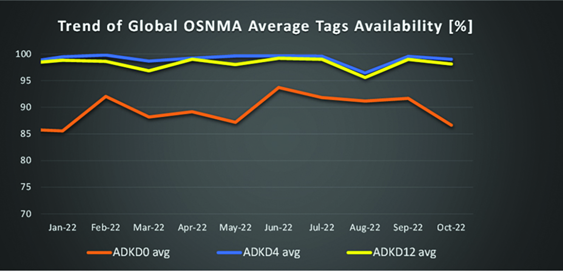
OSNMA-related metrics from January to October 2022.
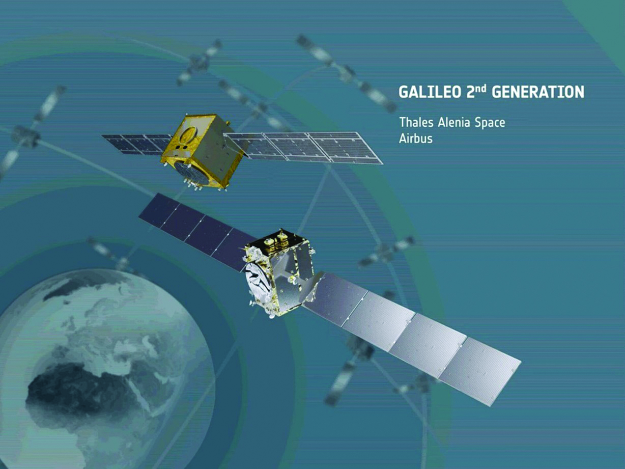
G2G Development Started
Galileo’s second generation (G2G) will introduce many innovative technologies to offer unprecedented precision, robustness, and flexibility.
2022 was a key year for the evolution of G2G activities with the fast development cycles of the first batch of G2 satellites, beginning development of the associated G2G in orbit validation (IOV) ground segment and system test beds, and the consolidation of the G2G final system capabilities — including the coordination of the mission/service roadmaps with the EC, EUSPA, and the EU Member States delegates.
Ariane 62 launcher.
G2G Satellite Manufacturing
From the satellite development point of view, the two parallel contracts to develop and manufacture each of the six G2G batch one (G2SB1) satellites are progressing in a fast development environment, with the first hardware units ready for integration and testing.
Following the completion of preliminary design review, these two contracts (for six satellites each) are preparing for unit-level validation/testing, which will lead to the critical design review.
These satellites will provide the following key innovations:
Reconfigurable fully digital navigation payload
Point-to-point connection between satellites by inter-satellite-link for command and control, and ranging functionalities
Electric propulsion for orbit-raising capabilities
Advanced jamming and spoofing protection mechanisms to safeguard.
The Galileo signals will improve with:
On-board authentication capabilities
Increased ground-to-space data rate
Improved time reference (number of clocks and advanced clock monitoring functions).
G2G IOV Procurements
2022 was also the year in which two key events took place with respect to G2G in-orbit validation (IOV) ground segment and system test bed procurements:
Finalization of the procurement cycle, now in the final evaluation/award phase, to be kicked off in the first quarter of this year
Confirmation of the IOV design through different coordinated actions with the EC and EUSPA, including the G2 system preliminary design review.
The contracts will provide Europe with the following capabilities:
G2SB1 satellite launch and early orbit phase, in-orbit testing and enhanced legacy services provision
G2 new capabilities in-orbit validation, including prototyping and validation of all the novel technologies that can exploit the full capabilities of the G2SB1 satellites.
Eleven contracts will be issued to manage in synchrony all the G1 and G2 assets for the coming years:
G2 IOV ground control segment (G2 GCS) for satellites monitoring and control
G2 IOV ground mission segment/secured facility (G2 GMS-GSF) for the production, dissemination and monitoring of all enhanced legacy services and the dissemination of new G2 advanced capabilities for validation
G2 IOV security monitoring (G2 SECMON), for the cyber/security monitoring of the system
G2 filling device (G2 FD), to ensure proper initialization of system assets
G2 system test bed (G2STB), to generate and monitor new G2 capabilities for validation of the G2G mission/services
G2 PRS test bed (G2PRSTB), similar to G2 system test bed but focused on advanced PRS capabilities for validation purposes
G2 security chain (G2SC), a test bed to ensure proper satellite-ground segment qualification before launch
Four system engineering support contracts (G2 SETA), where the main GNSS technical experts from different industries in Europe provide their support to ESA and EUSPA in their different fields of expertise.
These contracts are complemented by a significant set of system research and development and test tools, such as test user receivers and radio frequency constellation simulators.
G2G batch number one (G2SB1) satellites.
Galileo Second Generation System PDR
The Galileo Programme is not only focusing on short-term G2G development activities, but also looking forward to the future in terms of the consolidation and definition of G2G final operation capabilities. During the second half of 2022, more than 200 public representatives from the EC, EUSPA, ESA and Member States held countless meetings in the frame of the G2G system preliminary design review, which concluded in early December 2022.
As part of this review, the long-term implementation (G2G in orbit capability, or IOC, and final operational capability, or FOC) was reviewed and an agreement was reached on future steps. The evolution of Galileo capabilities will not only provide better services through advanced technical solutions, but will also ensure continuity of service and enhanced backward compatibility for first-generation legacy users.
Conclusions
The efforts of ESA and EUSPA continue with the aim of providing users continuous and stable services and evolving space and ground infrastructure to maintain Galileo competitiveness with the other global navigation satellite systems.
For analogous updates on the other three GNSS constellations, please see:
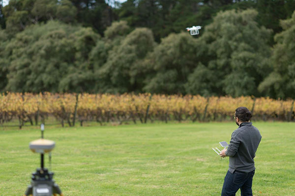
Trials in Australia are proving 5G LPP can support new positioning services. (Photo: Dan Woodrow, FrontierSI)
Several companies are joining to demonstrate 5G LTE Positioning Protocol (LPP) capabilities in field trials. The trials are part of the 5G Positioning Testbed funded under the Australian 5G Innovation Initiative.
Technology partners include GMV, FrontierSI, Ericsson and Optus, who are joining with industry demonstration partners Kondinin Group, Platfarm (a precision agriculture company) and Position Partners.
The results achieved by the project are considered a key step forward for the use of 5G technology for high-accuracy positioning. The testbed demonstrated each of the high accuracy GNSS-based LPP working modes, including Observation Space Representation (OSR), State Space Representation (SSR), and SSR with atmospheric corrections, integrated directly with user equipment supplied by demonstration partners to examine a variety of real-world applications. The field trials demonstrated that the solution can reach centimeter-level accuracy with fast convergence times using a commercial off-the-shelf receiver and antenna hardware.
GNSS precise positioning is the most common technology for calculating an absolute positioning solution at the user level. For uses requiring centimeter-level accuracy, it is often required to provide GNSS corrections to reduce errors.
Distribution of GNSS corrections is based on either the broadcast of precise point positioning (PPP) corrections through GEO satellites over the L-band, or the point-to-point transmission of real-time kinematic (RTK) corrections using NTRIP through the internet.
Both options have their drawbacks: GEO satellite broadcast requires complex ground infrastructure and can be expensive to maintain, while NTRIP distribution has poor scalability due to the point-to-point connections required for every user.
3GPP (3rd Generation Partnership Project) — the standards organization focusing on 5G LPP — recently introduced the support of OSR corrections for RTK users in Release 15, and the support of SSR plus atmospheric corrections for PPP/PPP-RTK users in Release 16.
Support for these two approaches to high-accuracy GNSS positioning have increased interest in 5G LPP as a potential alternative to existing correction services. Service providers and positioning consumers can now consider the use of 5G LPP as a supporting technology in the provision of new positioning services directly through mobile networks.
The 5G Positioning Testbed has achieved end-to-end demonstrations of high-accuracy positioning solutions using GMV’s Corrections Service and Positioning Engine, delivered through the Optus 5G network using Ericsson network technology, to user equipment designed and operated by FrontierSI.
Field trials conducted in Australia involved real-world scenarios across three areas: precision agriculture, drone operation and augmented reality.
The May 4-5 meeting of the National Space-Based Positioning, Navigation and Timing Advisory Board focused on its mantra to “protect, toughen and augment” (PTA) GPS. The meeting included three great presentations that bear directly on the A of that mantra.
CAST
The electric grid used to be simpler: regional operators flowed power unidirectionally from stations to customers basing the load on past usage. Now, the grid is becoming a wide-area network — with regional inter-connects, multi-directional flows, and load based on real-time data and predictive analysis, requiring sensors time-synchronized within 1 microsecond from UTC. Yet, this critical infrastructure’s timing applications depend entirely on vulnerable GPS technology.
“If we can provide an authoritative, trusted synchronization source across the interconnected grid, its operators have a much better opportunity to understand the interdependencies and movement of power across their networks,” said Carter Christopher of Oak Ridge National Laboratory. He described the lab’s Center for Alternate Synchronization and Timing (CAST), which provides a redundant and resilient satellite-based service backed up by a network of terrestrial master clocks. CAST is precise, traceable and secure from jamming, spoofing, cyberattacks and physical attacks.
HARS
Attila Komjathy and Larry Romans of NASA’s Jet Propulsion Laboratory (JPL) proposed a GPS high-accuracy and resilience service (HARS) based on global differential GPS (GDGPS). It would provide corrections to GPS orbit and clock errors, and encrypted navigation data bits over the internet. It would match Galileo in accuracy, they said, pointing out that Galileo, QZSS and BeiDou provide high-accuracy services in their broadcast signals. HARS would improve the accuracy of consumer GPS receivers of 3–5 m to 1 m and help ensure that multi-constellation GNSS chips would continue to rely on GPS first.
HARS could be implemented by having commercial providers—such as Apple, Google and cellular carriers—distribute GDGPS corrections generated by JPL and supported by government partners. Private industry, Komjathy and Romans pointed out, provide service for RTK, centimeter and decimeter apps, but only governments (the U.S. Coast Guard’s DGPS service and Galileo’s HAS) provide corrections for about one-meter accuracy. Therefore, HARS would not compete with industry and would create additional opportunities for it to create value-added products.
αPNT
David Castiel and Cyrus Langroudi, of Virtual Geosatellite LLC, proposed αPNT, a virtual geostationary satellite system with elliptical orbits that would provide active PNT in a distributed architecture integrated with a blockchain. The system, they said, would be able to provide very accurate geographical position, precise timing and guidance with a minimum number of satellites on the horizon. It would rely on two-way links between transceivers and satellites to protect against jamming or spoofing.
While GPS’s success makes it a critical and ubiquitous infrastructure, its vulnerabilities require and stimulate exciting new R&D. Stay tuned.
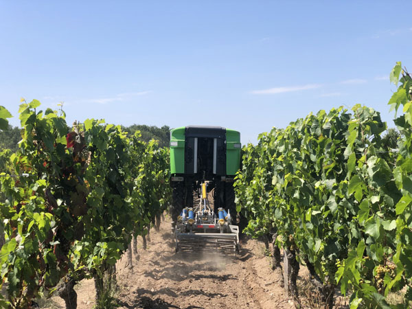
On a French vineyard in the Loire Valley, a tractor is driving between the grape vines with no one behind the wheel. Meet TREKTOR, the autonomous hybrid robot that works tirelessly to weed the organic vineyard producing some of the finest Gamay wine, called Anjou Gamay Village.
After TREKTOR worked the land for a month, its developer, a company called Sitia, reviewed the quality of their autonomous robot’s work. They counted grape vines damaged during operation — two in one month — and approached the farmer to reconcile the liability. To Sitia’s surprise, he responded, “When I use my manual tractor to get the same job done, I damage at least two vines a day! How did your tractor manage to be so careful?” Sitia’s developers thought for a while and then replied, “It’s thanks to the high quality and accuracy of the components that are inside.”
“Despite the strong magnetic field emitted by the generator on the TREKTOR, the AsteRx SB ProDirect receiver did not have any issues,” said Clément Aubry-Tardif, Sitia’s R&D manager. “The spectrum analyzer in its web interface showed other small radio interferences aboard the robot, but everything was still working fine.”
Integrated into the TREKTOR is an AsteRx SB ProDirect dual-antenna receiver, which provides the reliable high-accuracy positioning and heading needed for autonomous operation. Sitia chose the receiver for the following reasons.
It has centimeter-level accuracy with RTK, which reduces crop damage and increases yields.
Its heading helps point implements in the right direction. Unlike inertial systems, it’s reliable and accurate even in static or slow-moving applications.
Built-in advanced interference mitigation (AIM+) technology makes it resistant to radio interference, while its LOCK+ technology ensures robust satellite tracking even under intense vibrations or shocks.
It includes an intuitive web interface for fast prototyping and easy real-time testing.
Sitia is a French company specializing in autonomous robots. Its TREKTOR helps compensate for the current farmer shortage, which is especially felt on organic farms, where weeding is seven times more labor intensive due to the use of few (if any) herbicides. TREKTOR is a flexible solution that can adjust its height and width on the fly, adapting to various working environments. It can also change implements to perform various functions. Depending on TREKTOR’s dimensions and implements, the distance from the crop to the robot changes, making high-accuracy positioning crucial to minimize damage to any of the crops.
DDK Positioning solutions use the Iridium satellite constellation to deliver 5-cm GNSS accuracy to industrial users of the internet of things (IoT).
Iridium Communications Inc. has made a strategic investment in DDK Positioning, an Aberdeen, Scotland-based provider of enhanced GNSS accuracy solutions.
DDK uses the Iridium network to provide global precision-positioning services that can augment GNSS constellations, including GPS and Galileo, to significantly enhance their accuracy for critical industrial applications.
DDK is developing similar services for other GNSS constellations, such as GLONASS and Beidou. Terms of the investment are not being disclosed.
Standard positioning accuracy through a system like GPS is typically within 10 meters; however, by using the Iridium network, DDK’s enhanced GPS accuracy service brings incredibly precise positioning of 5 cm or less. This advanced level of accuracy is suitable for autonomous vehicles such as UAVs, precision agriculture applications, offshore infrastructure projects such as wind-farm construction, automotive applications like driverless cars, as well as a host of construction, mining, surveying and IoT use cases.
Historically, there have been limited geostationary satellite provider options for this type of service, but they suffer from line-of-sight blockage issues and coverage limitations in and around Arctic and Antarctic regions.
“We are delighted to have embarked on this journey with such a strong and well-respected company as Iridium,” said Kevin Gaffney, CEO of DDK Positioning. “This partnership is a perfect fit for DDK Positioning. With Iridium’s satellite communications network and our GNSS solution, we are in a position to deliver a truly unique service which is robust, resilient and secure. The investment made by Iridium will also allow us to grow the company even further whilst expanding our service offering globally.”
According to a report published by the European GNSS Agency, augmentation services like those offered by DDK will account for $76.5 billion (€65 billion) in global GNSS market revenue by 2029, while the global GNSS downstream market, including services delivered and hardware devices, is estimated to reach $382 billion (€325 billion).
“We are impressed with the team that DDK has put together and see great potential for this technology and how it takes advantage of the Iridium network,” said Iridium CEO Matt Desch. “DDK’s enhanced positioning is a unique capability that adds a high-value solution on top of our existing portfolio of custom network services. Solutions from Iridium and DDK partners that are focused on precision agriculture, autonomous systems, maritime and infrastructure projects can now experience incredibly precise GNSS accuracy from anywhere on the planet.”
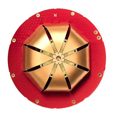
Tallysman Wireless Inc. has added four new embedded VeroStar Mini products to its line of antennas. The ultra-compact and lightweight embedded VeroStar Mini models offer the same key features as the full-size VeroStar models but in a smaller, lighter package, with either a 90-mm (58 g) or 106-mm (69 g) integrated ground plane, both 32.4 mm in height.
The VSM6028, VSM6028L, VSM6328 and VSM6328L embedded VeroStar Mini antennas are designed and crafted for high-accuracy positioning. With an exceptionally low roll-off from zenith to the horizon, VeroStar antennas provide the excellent tracking of GNSS and L-band correction signals at low elevation angles.
The VSM6028 VeroStar antenna. (Photo: Tallysman Wireless)
Also, the optimized axial ratio at all elevation angles results in excellent multipath rejection, enabling accurate and precise code and phase tracking. Additionally, VeroStar antennas feature a robust pre-filter and high-IP3 LNA architecture, minimizing de-sensing from high-level out-of-band signals, including 700 MHz LTE, while still providing a noise figure of only 1.8 dB.
The light and compact wide-band spherical antenna element enables the VeroStar Mini to deliver a ±2 mm phase center variation (PCV), making it suitable for high-precision applications such as autonomous vehicle navigation (land, sea, and air), smart survey devices, and maritime positioning.
The VSM6028 supports the full GNSS spectrum (the VSM6028L includes support for L-band correction services), while the VSM6328 supports the GPS/QZSS-L1/L2/L5, GLONASS-G1/G2/G3, Galileo-E1/E5a/E5b, BeiDou-B1/B2/B2a, and NavIC-L5 signals and frequency bands (the VSM6328L includes support for L-band correction services).
The unique features of the VeroStar Mini antennas guarantee it can deliver a high signal-to-noise ratio (SNR), high accuracy, and high precision in the most challenging environments.
Galileo and BeiDou observation data are now included with Trimble VRS Now subscriptions in North America.
Photo: Trimble
The addition of the Galileo and BeiDou constellations allow users to make use of more satellites, enabling more robust performance when working in harsh GNSS environments such as in urban canyons and under canopy, the company said.
Trimble VRS Now in North America fully supports GPS, GLONASS, QZSS and now, Galileo and BeiDou satellite systems.
The service is powered by the Trimble Pivot Platform GNSS real-time network software, Trimble said. As a true five-constellation solution, it delivers improved real-time positioning performance for customers in North America.
VRS Now is designed for surveying, mapping and GIS, construction and agriculture professionals who require high-accuracy positioning in their workflows.
Adding Galileo and BeiDou observation data provides significant benefits by enabling users to:
Operate in environments where traditional GPS + GLONASS systems’ performances are limited
Improve accuracy and reliability of GNSS solutions
Minimize the effects of multipath and interference
“By including Galileo and BeiDou data, customers can achieve greater accuracy and positioning performance than ever before,” said Patricia Boothe, vice president of Trimble’s Advanced Positioning Division.
With the addition of North America, Trimble VRS Now networks worldwide now support all five GNSS constellations. Besides North America, coverage is available throughout Europe, Australia and New Zealand when using a compatible GNSS receiver or display.
Subscriptions are available through Trimble’s Authorized Business Partners or Trimble’s online store at tpsstore.trimble.com.
VRS Now provides positioning professionals with instant access to real-time kinematic (RTK) and post-processing (PP) corrections using a network of permanent (fixed) continuously operating reference stations (CORS). Professional management and monitoring 24/7 by a global operations team provides peak performance and high reliability, Trimble said.