Septentrio, a leader in high-precision GNSS positioning solutions, has launched the Agnostic Corrections Partner Program.
The program facilitates the use of Septentrio receivers with high-accuracy services that provide varying levels of accuracy, coverage and delivery methods. This also allows users to select the service that suits specific applications and business models.
The Agnostic Correction Partner Program, which includes Polaris from Point One, Skylark from Swift Navigation, and PointPerfect from u-blox, provides documentation for the use of Septentrio receivers with these high-accuracy services.
Agnostic GNSS corrections refer to correction services that are not specific to a particular GNSS receiver or device. It provides correction data that can be used by any receiver that can process the correction signal. Agnostic corrections are useful in situations where multiple types of GNSS receivers are being used, such as in a large-scale surveying project or in a fleet of vehicles that use different types of navigation systems.
Galileo Control Centre in Oberpfaffenhofen, Germany. (Photo: ESA)
Spirent Communications plc has launched a commercially available simulation test solution for the Galileo High Accuracy Service (HAS), via a beta interface implementation based on HAS ICD version 1.2. During the development of the solution, Spirent collaborated with GMV, a leader in cutting-edge GNSS high-accuracy technologies.
Galileo HAS will provide free-of-charge high-accuracy Precise Point Positioning corrections through the Galileo E6-B signal, with accuracy under two decimeters, offering real-time improved user positioning performance. Developers need to be able to test their devices against this new service to ensure they can optimally capture the emerging capability when it becomes available. By integrating HAS simulation and capabilities, Spirent’s latest simulation solution enables customers to utilize and incorporate Galileo HAS as early as possible.
In February 2021, the European Union Agency for the Space Programme (EUSPA) awarded GMV with the contract for the implementation of the Galileo High Accuracy Data Generator (HADG), which will be the facility in charge of generating the high-accuracy corrections data to enable the provision of HAS. Spirent’s collaboration with GMV will prove a key element in the early adoption of the service.
“The high accuracy, feature richness and flexibility of Spirent’s simulator platforms provides an ideal foundation for the testing of innovative new Galileo services such as our recent Galileo HAS capability,” said David Calle, section head of advanced GNSS services at GMV’s aerospace sector.
“The high level of expertise and in-depth understanding of Galileo HAS within GMV provided important guidance as we implemented HAS on our simulation platform,” said Jan Ackermann, Spirent’s director of product line management. “This enabled us to again be the first in the industry to offer a commercial solution to simulate and test these important new capabilities.”
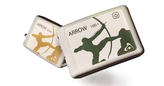
The Arrow Gold+ and Arrow 100+ plus models build upon the company’s highest demand GNSS receivers
Eos Positioning Systems, the global manufacturer of the Arrow series of GNSS receivers, has released two new Arrow Series GNSS receiver models: the Arrow Gold+ and Arrow 100+.
These plus model receivers expand upon the features of Eos’ two most popular GNSS standard receiver models, the Arrow Gold and Arrow 100.
Arrow Gold+
The Arrow Gold+ (Photo: Eos Positioning)
The Arrow Gold+ includes all the features of the standard Arrow Gold GNSS receiver model. However, the plus model also includes several enhanced features:
A battery life 3.5 hours longer, for a total of 11 hours of field autonomy
Support for additional GNSS signals, including concurrent use of BeiDou B3 and GPS L5 signals when using RTK corrections
Support for the upcoming Galileo E6 High-Accuracy Service (HAS), which will broadcast differential corrections for GPS and Galileo satellites directly from the Galileo satellites
Built-in capabilities of the Eos Bridge to connect with external sensors
The ability to connect multiple mobile devices to a single Arrow GNSS receiver via Bluetooth (sometimes called “multipoint”)
Arrow 100+
The Arrow 100+ (Photo: Eos Positioning)
Arrow 100+ includes all the features of the standard Arrow 100 GNSS receiver model. However, the plus model also includes several enhanced features:
A battery life 6 hours longer, for a total of 18 hours of field autonomy
Support for Atlas H50 (Basic) service subscriptions, which provides 30-50 cm positioning accuracy worldwide when no SBAS or RTK network is available
Built-in capabilities of the Eos Bridge to connect with external sensors
The ability to connect multiple mobile devices to a single Arrow GNSS receiver via Bluetooth (sometimes called “multipoint”)
For a full comparison between standard and plus model Arrow GNSS receivers, view this FAQ article.
An Eos representative can help customers determine whether the new plus models are right for your needs. Authorized Arrow GNSS receiver reseller, contact Eos online.
Rx Networks TruePoint.io global precise point positioning (PPP) correction service now provides quad-constellation support.
More mobile devices are integrating multi-constellation GNSS chipsets for better positioning. With quad-constellation expanded multi-constellation support, Rx Networks TruePoint.io global precise point positioning (PPP) correction service unlocks that accuracy, providing global PPP corrections for every major GNSS constellation those chips can track.
TruePoint.io global PPP originally delivered GPS and GLONASS corrections. Now, it also provides corrections for Galileo and BeiDou. Mass-market multi-constellation GNSS chipsets can now augment all their satellite measurements with accuracy and fully leverage their positioning capabilities with quad-constellation support.
Consumer devices now have the potential to achieve 50-cm position accuracy when using Rx Networks services for any of the four GNSS constellations. Other internet of things (IoT) and infrastructure applications that do not require real-time positioning can realize 10-cm accuracy in a variety of environments.
Multi-constellation correction capability ushers in new possibilities and use cases for the connected receiver, according to Rx Networks.
TruePoint.io remains ubiquitous and as flexible as possible to GNSS chipsets using industry standard formats, and is also receptive to custom integration services for unique usage scenarios. By offering PPP and other high accuracy services in a variety of data standards, TruePoint.io empowers telecom providers with a straightforward approach to integrating high- accuracy services that provide more value to their client devices, and propels the development of exciting new use cases.
“With this new expansion of TruePoint.io, applications already serviced by Rx Networks can accelerate their market growth objectives with better accuracy and precision using constellations ideal for target regions,” said Vincent Chen, product manager of Truepoint.io. “Being able to deliver global PPP corrections for GPS, GLONASS, Galileo and BeiDou also sets the stage for the addition of more constellations like QZSS. Stay tuned.”
GMV has been awarded a contract for the implementation of the Galileo High Accuracy data generator (HADG), which will be the facility in charge of generating the high-accuracy corrections data to enable the provision of the Galileo High Accuracy Service (HAS).
The contract was awarded by the European Union Agency for the Space Programme (EUSPA).
HADG will ensure the continuous provision of HAS data with a proper rate, accuracy, availability, continuity and latency. The data will encompass orbit and clock corrections, biases, quality indicators and service parameters.
The HADG contract addresses a key infrastructure development of the Galileo program. The Galileo HAS, together with the Open Service Authentication (OSNMA) and the Commercial Authentication Service (CAS), is one of Galileo’s stand-out services, setting it apart from GPS or GLONASS.
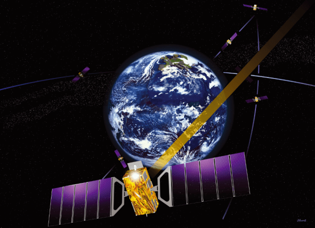
The HAS will be an open-access service based on the provision of high-accuracy corrections transmitted in the Galileo E6-B signal (E6, data component), at a rate of 448 bps per Galileo satellite connected to an uplink station. The data retrieved by the user from the different satellites offering the HAS will be reconstructed, allowing the user to achieve an improved positioning performance.
As the project’s leader, GMV will be responsible for core project activities such as the provision of the algorithms for the computation of the high-accuracy corrections, which rely on GMV’s MagicPPP software suite for precise point positioning. GMV is supported by SIDERTIA in the area of cybersecurity.
The specification , design and development phases have already been completed, and the project is progressing toward qualification of the system that will enable the execution of the necessary validation activities prior to the HAS initial service declaration, which is expected in 2022.
GMV presented the first version of MagicGNSS in 2008.
Thales Alenia Space, a joint venture between Thales (67%) and Leonardo (33%), has been selected by the European Commission for a new strategic contract to assess the feasibility of an integrity service to complement the European Global Navigation Satellite System (EGNSS) High Accuracy service, which will pave the way for use in autonomous vehicles.
Thales Alenia Space will focus on the development of a sensor-fusion approach, including and complementing evolutions of EGNSS High Accuracy. These service evolutions are aimed at providing the integrity level to serve the high-reliability and high-accuracy positioning needs of new, demanding applications such as autonomous vehicles on the road and autonomous transport in the maritime and rail sectors.
With this contract, Thales Alenia Space will assess the extension of the integrity and safety-of-life services for aviation into the road, rail and maritime sectors. In 2020, the company won the EPICURE project, based on an integrity concept for road travel (tolls and insurance), as well as the IMPRESS project, targeting an integrity service for rail signaling and train separation.
Thales Alenia Space has been a prime contractor for EGNOS (European Geostationary Navigation Overlay Service) for 25 years. It is a lead industrial contributor to the Galileo system and its ground mission segment and responsible for providing six Galileo Second Generation satellites. In April, the company was awarded a contract to support the implementation and experimentation of the navigation algorithms that will be used in the Galileo Second Generation program.
Spaceopal and the European GNSS Agency (GSA, the future EUSPA, the European Union Agency for the Space Programme) have signed a contract for the development of an innovative reference algorithm and user terminal for the Galileo High-Accuracy Service (HAS).
Spaceopal is the prime contractor for Galileo’s operational services.
Spaceopal is an equal-share joint venture between Telespazio, a Leonardo (67%) and Thales (33%) company, and DLR Gesellschaft für Raumfahrtanwendungen (GFR) mbH. Spaceopal will develop the solution with the support of its shareholders DLR-GfR and Telespazio, and partners such as ANavS GmbH, the DLR IKN, IABG mbH and Iguassu Software Systems.
The project, awarded within the “Galileo Reference High Accuracy Service User Algorithm and User Terminal” Call, will develop the reference algorithm for HAS, which will be made publicly available and will be used for its validation. The user terminals at a high technology readiness level provided to GSA will serve as a blueprint and further facilitate the adoption of the European GNSS.
Spaceopal will develop the solution in the next 12 months, followed by a 6-month period of providing engineering support to the GSA for testing activities, training and demonstrating the performance of Galileo HAS.
Leveraging on the experience of the NAVCAST precise positioning services, on the commitment of Spaceopal’s shareholders and on the skills of its industrial partners, Spaceopal will build a close-to-market solution for the validation of the Galileo HAS service.
“This contract is a substantial milestone in Spaceopal’s path to innovation excellence and confirms our commitment to support the GNSS services of the future. We are delighted to be trusted by the European GNSS Agency to develop this service further facilitating the adoption of the European GNSS, that will provide an unmatched accuracy for the HAS users,” said Sebastian Fedeli, Spaceopal’s sales and procurement director.
Galileo and EGNOS were the focus of attention at a special workshop at this year’s Intergeo in Stuttgart, which took place in September. Intergeo is the world’s leading conference and trade fair for geodesy, geo-information and land management.
Intergeo provided an opportunity to give an update on the status of the Galileo and EGNOS programs and to present user case studies at a special workshop focusing on the geomatics market.
In his presentation at the conference, Eduard Escalona, Market Development Innovation Officer at the European GNSS Agency (GSA), stressed the key role of GNSS.
“GNSS is a cornerstone in many areas: It is a fundamental element for cadastral surveying, in the construction sector, in mining, land surveying and mapping activities, for all geographic information systems (GIS), for infrastructure monitoring and for marine surveying. For all of you who are working in these and many other areas, Galileo is now helping to provide the GNSS services you need,” he said.
Dual-frequency boosts market
The European GNSS programs, Galileo and EGNOS, continue to move forward in terms of adoption by the professional market and among general users, thanks in no small part to the development of dual-frequency capability.
Traditionally, mobile, location-based applications have been powered by single-frequency GNSS receivers operating under stringent battery-power and footprint constraints. With a dual-frequency chipset, these devices now benefit from better accuracy, ionosphere error cancellation, improved tracking and better multipath resistance.
Galileo is leading the way in the area of dual-frequency signal delivery, now with more dual-frequency operational satellites in orbit than any other GNSS system. Market uptake of Galileo receivers has been impressive; in addition to the geomatics-related areas of particular interest to the Intergeo public, dual-frequency GNSS chipsets are also appearing in the automotive sector, where connected cars and autonomous vehicles present a clear and pressing need for accurate and reliable positioning information.
New services to come
“To date, more than one billion Galileo-enabled devices have been sold,” said Escalona, “but Galileo isn’t standing still, waiting. We are proposing new services to appear in the coming years.”
These include the much-anticipated High-Accuracy Service (HAS) and a new Authentication Service. “The HAS will be a free, globally available service providing an accuracy of 20 cm, with PPP [Precise Point Positioning] corrections,” Escalona said.
Meanwhile, the Authentication Service (OS-NMA) will provide protection against jamming, spoofing and meaconing on the E1B signal and a separate Signal Authentication Service (SAS) will provide an even higher level of protection on the E6 signal.
“EGNOS is currently working with GPS, but of course we are looking forward to augmenting Galileo in the near future,” said Sergio Cabrera Bona, EGNOS Service Adoption Tools Engineer at the European Satellite Services Provider, whose core activities comprise EGNOS operations and service provision.
“GNSS is critical in all of these fields, whether it is mapping and GIS, farming, forestry, thermal pictures, management of natural terrains,” Cabrera said. He listed other areas, including management and inspection of utilities, power networks, water supply, telecoms, drones, inventory, surveying, field campaigns and determination of perimeters in agriculture as areas where GNSS plays a key role.
“It is not possible to mention all of the activities where you need reliable positioning. What you have to know is that with EGNOS augmentations you already have a horizontal accuracy below one metre and a vertical accuracy below two metres, so this is a very good accuracy,” he said.
There is much more that could potentially be done right now, Cabrera explained. “Most of the professional equipment is already EGNOS-enabled, but in practice users do not always configure their equipment correctly to exploit this capability. EGNOS adoption and support is going ahead full speed, but in the GNSS device market, many users still do not know they can use EGNOS. So the education process remains an ongoing effort,” he said.
Cabrera explained that the EGNOS user support website can be an important part of this educational drive on the top of the help desk. “We have very interesting tools and resources available online. For example, we will have a new EGNOS usability map available very soon on the website. With this tool you will be able to easily see the current availability of EGNOS signals in your location, which will be very useful especially in urban environments, for example. We also have many user support services and there is a new mobile app coming, so please visit our website and take advantage of EGNOS. It is there for you.”
Introducing the GSC
Galileo services improvement expert Pedro Gómez Martínez informed participants about the European GNSS Service Centre (GSC), defining both the concept of operations as well as the procedures necessary to provide the services that the GSA offers to Galileo users.
“The European GNSS Service Centre is the single interface between the infrastructure and users of the Galileo open services, commercial service and search and rescue service (SAR),” said Gómez. “So the GSC is a center that provides experts, know-how, evaluation of capability, distribution of information and support for the provision of value-added services provided by the Galileo system.”
The GSC website is a core resource for Galileo users, Gómez said, reporting real-time system status and incident notifications, with a bank of key documents and a full-time help desk. “It is very important for us that this is a two-way interactive service that includes your feedback. We need you to report any incidents that you might experience related to the product, service and data provision. We are very interested in user satisfaction, and we want to know how you respond to improvements. And of course, in general, we are here to promote GNSS in all its forms, in all areas, for all users.”
The GSC launched a new version of its website in the run-up to the InterGEO event. “More than ever we are making it easier for you to engage in dialogue with us and to provide your feedback. This is very important to us with new services coming up in the future,” Gomez said.
Research fundamentals
“One of the very important responsibilities of the GSA is the management of a number of EGNSS research and development programmes,” said Eduard Escalona. “We have Horizon 2020, the European Union’s research Framework Programme. There we have a final call for proposals coming up in November, with a deadline in March 2020. The GSA also is overseeing the Fundamental Elements programme, which is funding research specifically targeted at developing Galileo-enabled chipsets, receivers and related technologies.”
To illustrate Escalona’s point, the presentations featured EU-funded GNSS-related research projects leveraging the accuracy and integrity offered by Galileo. Pere Molina of Geonumerics presented the MapKite project. Funded under Horizon 2020 and now completed, MapKite integrates an unmanned aerial system (UAS) and a mobile mapping aystem (MMS) for simultaneous capture of geo-data from the air and from the ground. Molina showed data from a successful corridor mapping exercise run using the MapKite system.