The sweeper Woxiaobai has been in service for a year. (Photo: Unicore)
Fall is a beautiful time of year. But when the leaves drop, it means a lot of sweeping for most of us. Not so for the 200 campuses and parks in China using IdriverPlus’ WO series of unmanned sweepers.
High-precision GNSS positioning plays an important role in making the autonomous units possible, providing real-time high-precision position, speed and time information.
The sweeper in Beijing’s Haidian Park. (Photo: Unicore)
Unicore’s high-precision GNSS technology and their products’ high reliability have enabled IdriverPlus’ unmanned sweepers and logistics vehicles — China’s first mass-produced products in intelligent driving. In January, IdriverPlus received the green light to test self-driving cars in Beijing.
Diagram: Unicore
Sweepers and logistics vehicles are not only used in open-sky areas, but also in complex environments shadowed by buildings or trees or experience multipath. These areas include school campuses, factory and science parks, and community squares.
Complex environments result in different GNSS availability, reliability and convergence. In autonomous driving, the inputs the vehicle receives from GNSS and other sensors must be accurate and reliable.
A customer removes her express package from the Wobida logistics vehicle. (Photo: Unicore)
The UM482 module used by the IdriverPlus is characterized by dual antennas, compact dimensions, high performance and low cost, providing anti-jamming performance.
Integrated with on-board MEMS and Unicore’s U-Fusion combination technology, the UM482 can effectively solve the disruption of positioning results caused by the loss of satellite signal, and further optimize the continuity and reliability of positioning and heading outputs in complex environments such as city canyons, buildings and tunnels.
The ZED-F9K turnkey solution minimizes the effort required to achieve decimeter-level positioning accuracy in automotive applications.
Siemens has integrated the u-blox ZED-F9K high-precision dead-reckoning module into its Toyota Prius V2X (vehicle-to-everything) test fleet. Siemens carried out live demonstrations of the technology at ITS European Congress 2019 in Eindhoven, the Netherlands.
As the only available source of absolute position, GNSS-based positioning plays a crucial role in advanced driver automation systems and driverless vehicles. The same is true in V2X communication, in which vehicles continuously share their location and other information with other traffic participants — cars and pedestrians — as well as surrounding infrastructure, improving road safety and reducing traffic congestion.
V2X test vehicles typically determine their position using high-end GNSS receivers. By opting to use the ZED-F9K, Siemens was able to align the performance of their test fleet with real-world conditions while also reducing the cost and the engineering effort required to develop their vehicles.
Siemens conducted V2X tests using the u-blox ZED-F9K during ITS European Congress 2019. (Photo: u-blox)
“We’ve had a very positive experience with u-blox’s ZED-F9K high precision dead reckoning solution. The product delivered strongly from the initial design-in to the data and performance in our first tests,” said Igor Passchier, engineering fellow, Connected and Automated Driving at Siemens PLM Software.
“Our collaboration with Siemens shows the extent to which the ZED-F9K turnkey solution saves OEMs time, cost, and engineering effort while providing decimeter-level positioning performance,” said Alex Ngi, Product Strategy for Dead Reckoning, Product Center Positioning, u-blox. “For us, it has also been a welcome opportunity to contribute to solving the challenges in the autonomous driving ecosystem.”
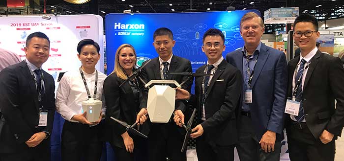
The Harxon team at AUVSI Xponential. (Photo: Harxon)
Harxon showcased its full range of UAV antennas and technologies for various UAV applications — especially for UAV base stations — at AUVSI Xponential, which took place April 30-May 2 in Chicago.
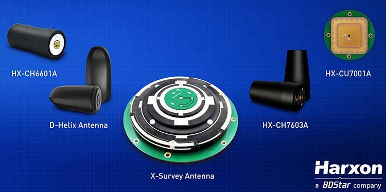
Harxon’s newly launched X-Survey antenna offers a 4-in-1 design for multi-constellation GNSS signal reception. It integrates Wi-Fi, Bluetooth and 4G modules for easy integration into real-time kinematic (RTK) systems.
It also ensures centimeter accuracy for precision positioning of UAVs, and stability of signal transmission, which provides the navigation and communication performance required by UAV base stations.
Additional UAV antenna products and technologies on display at booth #2218 include the HX-CH7011A and HX-CU7001A, new OEM antennas with small size and low weight, but with high gain and a stable phase center. Other available antennas include HX-CH7603A, HX-CH6601A, HX-CH7603A and HX-CSX601A for UAV and surveying applications.
Image: Harxon
Skycatch collaboration. Harxon has established strategic relationships with many industrial enterprises, such as Skycatch. Skycatch is an industrial data-collection and analytics company that focuses on indexing and extracting critical information. It provides combination GNSS base station and drone data-processing solutions that deliver high accuracy maps and point clouds in the 30 minutes or less.
Harxon — which specializes in GNSS positioning and navigation — is collaborating with Skycatch to give customers the opportunity to improve their UAV base station mapping solutions, and to maximize UAV operation efficiency and reliability.
High-precision GNSS solutions. The UAV industry, driven by new technologies, is one of the most dynamic growth sectors in the construction industry. The next phase of the drone revolution is flying towards standardization with precision solutions.
Harxon’s high-precision GNSS positioning technologies have been widely used in UAV-related applications, including UAV base stations, UAV power patrols, plant protection and machine control.
Guest column by Peter Fairhurst, Director, Product Line Management, Product Center Positioning, u-blox
Peter Fairhurst, Director, Product Line Management, Product Center Positioning, u-blox. (Photo: u-blox)
A new generation of GNSS hardware and pioneering new correction data services are enabling cheaper, more compact and truly scalable high-precision GNSS solutions, ready for the mass market.
High-precision GNSS as employed by specialized markets for more than a decade isn’t aren’t suitable for mass-market autonomous vehicles or other mainstream use cases. As well as being big, heavy and expensive, traditional high-precision GNSS systems don’t scale, which is a critical shortcoming when you consider this capability may very soon need to be built into every car that gets built.
To overcome these challenges, we’re seeing two complementary things coming to market: a new generation of GNSS hardware, and pioneering new correction data services. These two key facets combine to enable cheaper, more compact and truly scalable high-precision GNSS solutions, ready for the mass market.
A new generation of GNSS correction service forgoes the two-way link between customer device and the correction data service that is a hallmark of traditional high-precision GNSS corrections. Instead of sending each device its own, location-specific GNSS correction data, the new-generation services create a real-time model of relevant errors across their entire territory. They broadcast this over satellite and/or the Internet for customer devices to pick up.
Transmitting modeled GNSS error data to receivers across an entire region – as opposed to maintaining a two-way link with each and every device – opens the door to large-scale, mass market applications of high-precision GNSS
The shortcomings of traditional high-precision positioning
Correction data has long been key to high-precision GNSS services. In traditional applications, the customer’s positioning device detects its approximate location and sends this information to its correction service provider. This provider uses a network of base stations to monitor GNSS errors, comparing the readings calculated from the satellite signals to the stations’ known, fixed positions. It uses these insights to send the customer’s device tailored correction data, based on its location.
The technology has successfully been used to provide centimeter-level accuracy in surveying, agriculture and machine control, but annual subscriptions of sometimes more than $1000 per device mean it’s remained confined to specialized markets.
Moreover, traditional correction data services typically only operate in one country, or even one state. While this may not be an issue in some applications (such as localized agriculture), there are other use cases where limited range is a major problem. Imagine, for example, that you regularly need to travel across a state or national boundary in your (semi-) autonomous vehicle, or carry out remote UAV-based surveying in another country: maintaining your high-precision positioning capability is likely to mean roaming contracts and other extra costs.
The other issue with these traditional services is scalability. They use two-way cellular communication to pass data back and forth between the customer device and the correction data provider. And while this works when device density is relatively low, if this number grew to thousands or even millions of end-user pieces of kit trying to access the correction data service, current cellular infrastructure would struggle to deliver the required reliability. Particularly in safety-critical applications, where losing access to the correction data service could put lives at risk, this is unacceptable.
Image: u-blox
Recent developments in high-precision positioning
The new generation of GNSS correction services, creating and broadcasting a real-time model of relevant errors across their entire territory, over satellite and/or the internet for customer devices to pick up, opens the door to large-scale, mass-market applications of high-precision GNSS. Technology using State Space Representation (SSR) is one flavor of these new-generation GNSS correction data services.
Japan has led the way in GNSS error-broadcasting, using the L6 signal of its QZSS satellite network as a proving ground for mainstream use of the approach. Although it’s currently only available within Japan, the Centimeter Level Augmentation Service (CLAS) is generating a lot of interest across the automotive, agricultural and machine-control industries. Mitsubishi Electric, for example, used the CLAS service to field-test its autonomous driving system.
In China, Qianxun Spatial Intelligence Inc. is pioneering a different technique. Instead of broadcasting the data, Qianxun SI is leveraging its special access to the Chinese GNSS reference base stations to push the boundaries of what’s possible using the traditional technique. It provides tailored correction data services to customers including individuals, system integrators and original equipment manufacturers (OEMs). While it’s been a success in China, the approach is less appealing to OEMs who ship worldwide, because it requires their clients to arrange their own, local GNSS correction data.
Another important advance has been the rise of multi-band GNSS receivers, which enhance standalone positioning accuracy, thereby delivering a better customer experience in a variety of use cases. However, even multi-band receivers can’t achieve the centimeter-level accuracy that mobile robotics and autonomous vehicles need: these devices will always need to be complemented by some form of correction service.
Continent-wide GNSS correction data
Particularly in Europe, where there’s a lot of cross-border travel and economic activity, the simplicity of continent-wide GNSS correction services would offer enormous value. Sapcorda, for example, a recently launched joint venture between Bosch, Geo++, Mitsubishi Electric and u-blox, is creating a next-generation GNSS correction data service with coverage on a global scale (Europe, North America, etc), building on the lessons learned in Japan.
Sapcorda will broadcast right across the continent, using cellular networks as well as over satellite links. Customers won’t be tied to a specific GNSS manufacturer. Data will be distributed in an open format, so that device-makers can create exactly the solutions their customers want.
Having access to GNSS correction services continent-wide has the potential to transform high-precision positioning into a mainstream offering, supporting various IoT applications, as well as drones and (semi-) autonomous vehicles.
Addressing the remaining challenges
High-precision GNSS correction services that target the mass market are still relatively new, with different suppliers pursuing different business models. Trimble’s service, for example, doesn’t use an open correction-data format, and is only compatible with devices using its own GNSS receivers. The benefit of this is that it can deliver a seamless, fully integrated solution, with complete interoperability across the Trimble product range (provided the region in question has good coverage). OEMs with customers is geographically broader markets will need to weigh this up against the benefits of global coverage provided by a range of correction-data suppliers offering open-format data.
As we touched on earlier, in safety-critical applications where location-accuracy is essential, any correction data service must be up to the task. This includes ensuring data broadcasts aren’t crowded out when cellular networks become saturated. To this end, u-blox has been working with the 3GPP body to create appropriate standards that can ensure the service meets the required service level agreements.
Lastly, although there’s now country-wide coverage in both China and Japan, Sapcorda is now attempting to provide continent-wide high-precision services. If it’s a success, it could overcome the challenges of national boundaries and country-based cellular providers. It’s as yet unclear how existing correction-data-service suppliers will respond.
Customer satisfaction is paramount
For high-precision GNSS services to achieve mainstream success, they not only need to offer wide coverage and be truly open, but must facilitate innovation and ensure they can broaden the appeal of this capability beyond being a niche specialism. Like in any industry, customer satisfaction is essential if the technology is to achieve this.
Complexity that arises as a result of state boundaries, national borders, conflicting regulations or subscriptions, must be shielded from the end user and dealt with upstream. This is already happening in some areas, where device-makers are partnering with correction data service providers, enabling them to bundle the service cost into the device cost that the end user pays.
A revolution in positioning
As well as helping to realize some of the automated navigation solutions currently under development, new-generation high-precision GNSS services are driving a seismic shift across the whole industry.
The rise of innovative, high-precision GNSS technology, combined with business models that promise to make high-precision a mass market reality, mean the coming years will be tremendously exciting. By disrupting the existing market, the new technology will mean lots of new opportunities for those ready to grasp them.
Peter Fairhurst joined the Product Strategy team in the Product Center Positioning at u-blox AG in 2015. He is responsible for the development of industrial markets, with a specific focus on unmanned systems and mapping solutions. Prior to u-blox, he was part of the Product Management group at Leica Geosystems AG, where his focus was on high-precision GNSS surveying technology.
Fairhurst holds a bachelor degree in Mathematics & Computer Sciences and doctorate degree in satellite geodesy from Newcastle University and an MBA diploma from the University of Strathclyde.
Septentrio, a high-precision GNSS company, and Sapcorda, a specialist in GNSS correction services, will conduct a live demonstration of a safe, high-accuracy positioning and correction solution for automated driving.
“We are running the demonstration during the course of this week just south of Las Vegas city center,” Neil Vacans told GPS World. Vacans is Septentrio’s vice president of global Sales. The demonstration is taking place in Las Vegas during the Consumer Electronics Show, being held Jan. 8-11.
Sapcorda and Septentrio have put together a solution that is ready for demonstration in Europe and North America.
The companies have combined their respective technologies to deliver the benefits of SSR (space state representation) technology seamlessly to OEM automakers and Tier 1 integrators. These benefits include decimeter-accuracy within seconds, anywhere over an entire continent, to support autonomy levels from lane keeping to full autonomy in a totally homogeneous coverage, the companies said.
The GNSS augmentation service is scalable through simple broadcast corrections, and safety-awareness is provided via Sapcorda’s integrity concept and Septentrio’s integrity monitoring engine.
In December 2018, Septentrio announced its mosaic compact multi-constellation GNSS receiver SiP (system-in-package) module, available in 2019. The Septentrio mosaic, a multi-band, multi-constellation receiver in a low-power surface-mount module with a wide array of interfaces, is designed for mass-market applications like robotics and autonomous systems. The mosaic module integrates the latest GNSS and RF ASIC technology, as well as the robust positioning engine from Septentrio.
All Septentrio GNSS receivers and modules feature AIM+ technology, an advanced on-board interference mitigation commercially available. Septentrio GNSS receivers can suppress the widest variety of interferers, from simple continuous narrowband signals to the most complex wideband and pulsed jammers.
“We are excited to be able to provide live demonstrations of Sapcorda’s safe and precise correction service especially designed for autonomous driving,” said Jan Van Hees, business development director at Septentrio. “Sapcorda provides a unique high-precision GNSS correction service designed for fast, homogeneous accuracy at continental coverage, thus ideal for autonomous and mass market applications.”
“Septentrio specializes in high-precision and high reliability GNSS positioning for a variety of industrial and commercial markets,” said Goran Jedrejčić, business development manager at Sapcorda. “They have developed a range of technologies, including unique jamming robustness and integrity positioning to support safety-sensitive applications in various challenging environments. Combining this with our safety-centered correction service, it is a unique solution for developers of autonomous driving systems.”
“With fast and efficient implementation of Sapcorda SSR-based correction service into Septentrio’s GNSS-platform, we were able to demonstrate the efficiency of the technology for automotive use in a robust & highly efficient way,” confirmed Jedrejčić. “Septentrio offers a unique blend of GNSS-based technologies and is an ideal partner for both traditional and new markets, with growing demand for high-precision positioning.”
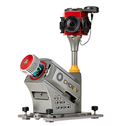
CHC Navigation has launched the Alpha3D Mobile Mapping solution, which provides a unique combination of sensor technologies and the company’s core GNSS expertise.
The Alpha3D is a high-performance, vehicle-independent mobile mapping solution that can capture mass data in continuously changing world environments, enabling geospatial professionals to get work done quickly and more accurately to increase their return on investment.
The Alpha3D can be mounted on a variety of platforms, including different type of vehicles, trains, railway trolleys and boats. It rapidly and efficiently collects high density, accurate point clouds and powerful image data. It also adds extra information from additional sensors, such as a high-resolution camera, thermal camera, echo sounder or extra profiler.
The Alpha3D combines high-performance hardware — including a long range, ultra-high speed, precise laser scanner, high-resolution HDR panoramic camera in combination with an advanced GNSS receiver and high-precision inertial measurement unit (IMU) — in one instrument in a light weight, compact yet rugged design, according to George Zhao, CEO of CHC Navigation.
“All theses features keep Alpha3D as one of most innovative system in market today,” Zhao said.
“With Alpha3D, users can collect more data faster and reduce time in the field more than 40% compared to traditional surveying instruments,” said Andrei Gobb, product manager of Mobile Mapping Solutions. “By combination of point clouds and high-resolution images, as well as information from additional sensors, there is no need to return to site for remeasurement.”
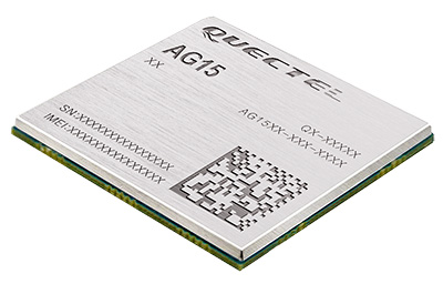
Quectel Wireless Solutions has launched the automotive-grade C-V2X module AG15, which features the Qualcomm 9150 C-V2X chipset solution from Qualcomm Technologies, a subsidiary of Qualcomm Incorporated.
Image: Quectel
The module is now sampling to the automotive industry for the development of commercial C-V2X products.
The AG15 C-V2X module is manufactured in accordance to IATF 16949:2016 quality management system standard for the automotive sector, and it fully complies with the automotive product quality processes, including APQP and PPAP.
Pairing with the Quectel automotive-grade LTE module AG35, Quectel’s AG15 is designed to meet the telematics and vehicle-to-everything (V2X) connectivity requirements of the next-generation automotive applications, such as autonomous driving and road safety.
Also known as LTE-V2X, C-V2X is the V2X communication technology based on the globally recognized Third Generation Partnership Project (3GPP) Release 14 specifications. The PC5-based direct communication mode of C-V2X supports vehicle-to-vehicle (V2V), vehicle-to-infrastructure (V2I) and vehicle-to-pedestrian (V2P) communications on the 5.9-GHz intelligent transport system (ITS) spectrum.
In addition, C-V2X paves a strong evolution path toward 5G new radio (5G NR) and plays an essential part of the future of safe autonomous driving with its capabilities including non-line-of-sight (NLOS) sensing to support high-speed mobility and high vehicular density deployments, the company said.
For positioning function, the AG15 features a built-in multi-constellation high-precision GNSS (GPS/GLONASS/BeiDou/Galileo/QZSS) receiver, with additional support from satellite-based augmentation systems (SBAS) and Qualcomm 3D dead-reckoning technology, which greatly improves the positioning accuracy and speed while simplifying customer designs.
Based on C-V2X technology, the Quectel AG15 module adopts the 3GPP Release 14 C-V2X PC5 protocol. It is designed to allow low-latency, highly reliable and highly dense data exchange between vehicles and their surroundings, enabling effective information sharing among road users in avoidance of collisions, thus improving automotive safety, automated driving and traffic efficiency.
Without the need for a subscriber identity module (SIM), cellular subscription or network assistance, the C-V2X direct communication mode helps reduce complexity and cost for customers.
Additionally, the Qualcomm 9150 C-V2X chipset solution has a built in A7 application processor (1.5 GHz), which could be potentially utilized to run ITS stack and associated C-V2X applications.
“We are very pleased to introduce our first batch of automotive grade C-V2X modules based on the Qualcomm 9150 chipset solution. Automated driving has unique requirements for V2X connectivity, such as lower latency, higher reliability and wider bandwidth, all of which could be addressed by C-V2X technology,” said Patrick Qian, CEO of Quectel. “Built upon Quectel’s expertise in connected vehicles and Qualcomm Technologies’ high-performance C-V2X chipset solution, the AG15 module is expected to help automakers and Tier 1 suppliers to effectively accelerate their efforts towards automated driving.”
“Quectel is a global leader in cellular modules with rich experience in commercial automotive products,” said Nakul Duggal, vice president of product management, Qualcomm Technologies. “We are pleased to work closely with Quectel again to support its modules with our 9150 C-V2X chipset solution to help create safer and more efficient V2X solutions and to help empower road safety and autonomous driving. We look forward to working with Quectel in delivering the solutions required to address the needs of the next generation automobiles.”
This announced version of Qualcomm Technologies’ precise positioning framework supports single-frequency GNSS utilizing real-time kinematic (RTK) technology based on the GNSS receiver built into Qualcomm Snapdragon LTE modems and Qianxun SI’s precise positioning technology — all integrated in an automotive-grade LTE module provided by Quectel.
Using Qualcomm 3D dead-reckoning technology, the precise-positioning framework will enable automakers with a comprehensive 3D navigation solution combining multi-constellation GNSS precise positioning, inertial measurement units and other sensors to support next-generation vehicle capabilities, the companies said.
Capabilities include high-performance connected navigation as well as LTE-V2X vehicle-to-everything communications (also referred to as C-V2X PC5 across the globe) for enhanced road safety, improved traffic efficiency and autonomous driving.
Qualcomm Technologies’ precise positioning framework is designed to facilitate open-sky positioning performance from up to 3 meters to less than 1 meter, supporting lane-level positioning and potentially achieving accurate locations from a centimeter to a few decimeters when combined with select third-party GNSS correction services.
This framework is also designed to support a safer and convenient automated driving experiences (level 2 and above), as well as LTE-V2X applications based on positioning, velocity and heading information. Integrated into telematics modules based on the Snapdragon LTE modems, the precise positioning framework supports a cost-effective solution for automakers already including cellular connectivity into their vehicles.
“The efforts with Qualcomm Technologies and Quectel not only assists automakers in addressing the cost and complexities of integrated precision positioning services, but it also aids in creating hardware and service standards for the industry to promote this capability as a public service in the field of connected cars,” said Jinpei Chen, CEO of Qianxun SI. “We look forward to working with Qualcomm Technologies and Quectel to help deliver a solution for higher accuracy and positioning, particularly in dense environments such as in China.”
“In efforts to meet the positioning service requirements of mainstream automakers and Tier 1 suppliers, we felt that working with technology leaders like Qualcomm Technologies and Qianxun SI would be the best to deliver an intelligent, cost-effective and high-quality telematics module,” said Penghe Qian, CEO of Quectel. “The AG35 is our newest generation of automotive-grade modules that enables 4G connectivity and lane level positioning simultaneously, allowing the adoption of LTE-V2X and HD Map technologies on a broad scale.”
“The automotive industry is becoming increasingly dependent on high performance positioning technologies to support connected navigation, safety services and vehicle autonomy,” said Nakul Duggal, vice president of product management, Qualcomm Technologies, Inc. “At Qualcomm Technologies, our proven positioning and system integration capabilities, along with Quectel and Qianxun SI’s solutions, can provide customers with cost-effective precise positioning solutions. We are pleased to be working with China’s leading technology companies like Quectel and Qianxun SI to advance next-generation automotive capabilities that will drive the automotive industry forward.”
New research conducted at the University of Otago, New Zealand, and published in the August issue of Journal of Geodesy demonstrate that it is possible to achieve centimeter(cm)-level precise positioning on a smartphone.
The research, conducted in collaboration with Curtin University, Australia, combined signals from four different GNSS, according to Otago’s Dr. Robert Odolinski and Curtin University colleague Prof. Peter Teunissen.
“It’s all down to the mathematics we applied to make the most of the relatively low-cost technology smartphones use to receive GNSS signals, combining data from American, Chinese, Japanese and European GNSS. We believe this new capability will revolutionize applications that require cm-level positioning,” Odolinski says.
He said to understand the new technology, a look back at the historical scientific context is needed.
Precise centimeter-level positioning on a smartphone during 24 hours in Dunedin, New Zealand. Blue dots show repeatability of one epoch data in comparison to precise benchmark coordinates. The repeatability is more or less the size of a one-dollar New Zealand coin (diameter of 2.3 cm) in all three dimensions. (Image: University of Otago)
“For decades, construction, engineering, cadastral surveying and earthquake monitoring have relied on high-cost, dual-frequency GPS positioning to obtain centimeter-level location information. The challenge is that GPS signals, traveling from Earth-orbiting satellites to receivers on the ground, are disrupted along the way, and this generates errors and limiting precision.
“The traditional solution is to combine GPS signals sent at two different frequencies to improve the positions, but the antennas and receivers required have been expensive, far beyond the reach of many who would benefit from the technology,” Odolinski said.
The new approach uses only one of two frequencies but collects data from more satellites for a multi-constellation GNSS solution. The extra data and algorithms are used to improve the positions without adding cost.
Odolinski and Teunissen have shown that this approach can work in smartphones, producing competitive results compared to dual-frequency GPS solutions (see figure).
Odolinski believes that countries and industries of all sizes can benefit from using smartphones as GNSS receivers, and is confident commercial application and development will spring from this research.
“This significant reduction in costs when using smartphones can increase the number of receivers that can be deployed, which will revolutionize a range of disciplines requiring centimeter-level positioning, including precise car navigation, surveying and geophysics (deformation monitoring), to name a few.”
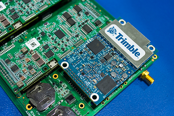
MicroPilot Inc. has teamed with Trimble to integrate high-precision GNSS technology as part of its autopilot for guidance and control of unmanned aerial vehicles (UAVs).
With centimeter-level, real-time kinematic (RTK) positioning capabilities, Trimble’s multi-constellation GNSS receivers are capable of tracking signals from GPS, GLONASS, Galileo and BeiDou, the company said. Trimble GNSS receivers are used in a wide variety of applications ranging from port automation and robotics to autonomous vehicle guidance.
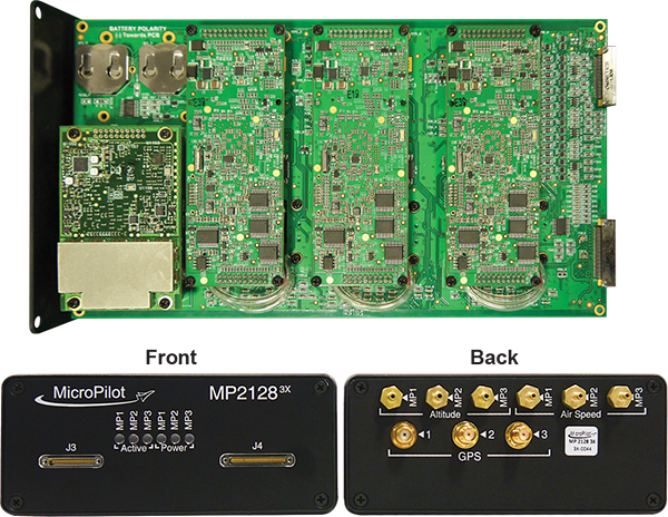
MicroPilot develops and manufactures autopilots for UAVs, including the triple-redundant MP21283X. The company also provides support products that enable customers to use their development time as efficiently as possible and bring their products to market faster. These products include the trueHWIL2 UAV autopilot simulator and the XTENDERmp software development kit.
The MP21283X UAV autopilot. (Image: Micropilot)
Working closely with Trimble gives MicroPilot the ability to better leverage Trimble’s GNSS technologies. This access improves the ability of MicroPilot’s support team to assist customers with their product development, testing and operations. Trimble will benefit from MicroPilot’s extensive experience integrating guidance, navigation and control systems for a wide variety of UAV platforms, the companies said.
“Reliable, robust and innovative GNSS solutions as well as strong technical support is key to bringing any UAV to market and our relationship with Trimble will allow MicroPilot to improve on our already industry-leading support,” said MicroPilot president Howard Loewen.
“We are very pleased to be working closely with MicroPilot to provide high-precision GNSS for its UAV autopilot solutions,” said Joseph Carey, director of strategic initiatives for Trimble’s Integrated Technologies Division. “MicroPilot autopilot’s simple installation, configuration and customization capabilities allow UAV manufacturers to easily integrate reliable, state-of-the-art, professional guidance, navigation and controls to their aerial platforms.”