Tag: high-resolution imagery

  • Mosaic debuts Mosaic X, compatible with REIGL mobile laser scanners

    Mosaic debuts Mosaic X, compatible with REIGL mobile laser scanners

    Photo: Mosaic
    Photo: Mosaic

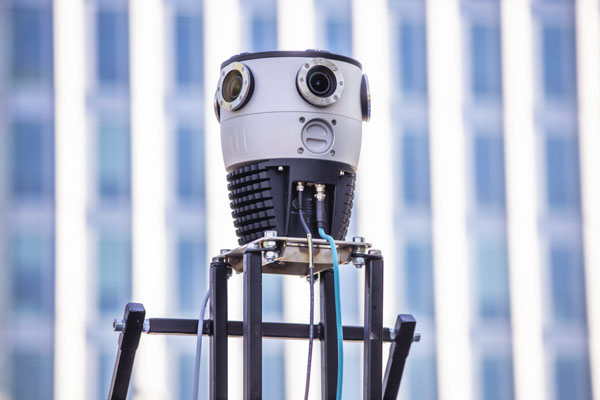
    Mosaic, a geospatial imaging company, announced that its new Mosaic X high-resolution, spherical camera is now compatible with RIEGL’s mobile mapping systems.

    The development of the Mosaic X focused on delivering a high-resolution, global-shutter, 360-degree camera with precise GNSS time stamping to achieve extreme visual clarity and accuracy at once. These qualities fit the requirements to be integrated with mobile laser scanning systems such as the RIEGL VMX, VMQ and VMY series.

    Mobile mapping has uses across many industries and sectors, including private and public organizations. The two most consistent demands when mapping infrastructures are high-resolution, photo-realistic imagery and highly accurate data. Cameras such as the Mosaic 51 and Mosaic X capture road infrastructure with photo-realistic accuracy, which is more understandable to the human eye than a point cloud from a laser scanner.

    “The pairing between 360-degree imaging systems and mobile laser scanning systems results in high precision LiDAR-based point clouds, colorized by photo-realistic images,” says Mosaic co-founder and VP of engineering, Rostislav Lisovy. “This outcome will then have the benefit of both a precise point cloud and panoramic images – for precise measurements and evaluation of textures.”

    The push for sensor integration came from the customers, Mosaic CEO and co-founder Jeffrey Martin states. “We have had many requests from our customers who are looking to use RIEGL and Mosaic products in unison. The Mosaic X impresses with high-resolution panorama images and offers precisely time-stamped single-lens imagery for the purpose of point cloud coloring as well as the generation of undistorted, geo-referenced high-resolution imagery with 12 [megapixels] per lens.”


  • Nearmap expands, capturing aerial imagery of 80% of US population

    Nearmap expands, capturing aerial imagery of 80% of US population

    Nearmap will capture aerial imagery of more than 80% of the U.S. population up to three times a year, enabling clients to access 130,000 square miles of additional content, including double the urban coverage of oblique/3D content

    Aerial imagery and location intelligence company Nearmap has expanded its United States coverage program to more than 80% of the country’s population. This massive boost in coverage provides companies that rely on high-resolution aerial imagery with improved decision-making capabilities that will help them save time, effort and money, Nearmap stated in a press release.

    “Nearmap customers have asked us to increase the amount of the U.S. that we cover and we’re responding by doubling down on our coverage,” Tony Agresta, general manager of North America, Nearmap said. “Our clients will have access to 130,000 square miles of additional unique captured footprint in the United States.”

    Overall, the Nearmap capture program will cover more than 1,740 urban areas within the United States, including more than 80% of the population with 308,000 unique square miles captured annually.

    In capturing aerial imagery, Nearmap focuses on currency, consistency, coverage and ease of access. The imagery is published within days of capture, with 24/7 access through a web app, API or third-party integration.

    “Around 11,300 customers worldwide rely on Nearmap to be their eye in the sky, and to provide them with the truth on the ground,” Agresta said. “We’re seeing strong momentum with new and existing customers in the United States. This massive boost in coverage reflects the broader investment and focus Nearmap has on the strategically important U.S. market.”

    Features of the expanded mapping coverage include:

    • 130,000 square miles of additional unique captured footprint in the United States, equivalent to about 63,000 football fields
    • double the number of urban areas covered with oblique/3D content
    • access to current content, with updates up to three times a year, including leaf-off and leaf-on collection
    • images at a high resolution, ranging from 2.2 to 3 inches.

    Across the world, Nearmap will also capture more than 64% of the population in Canada; more than 90% of the population in Australia, and about 73% of the population in New Zealand.

    “The expanded aerial coverage complements our city-scale 3D content, artificial intelligence (AI) data sets, and geospatial tools,“ Agresta said. “Nearmap has also recently tested in flight the next generation of our patented aerial camera system, HyperCamera3, to ensure our clients are supported by the very best technology in the market.”

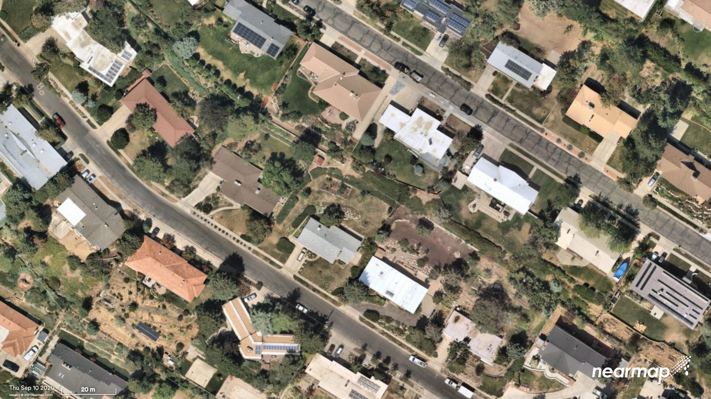
    A Salt Lake City neighborhood. (Photo: Nearmap)
    A Salt Lake City neighborhood. (Photo: Nearmap)
  • Airbus strengthens imagery capabilities with Vision-1

    Airbus has enlarged its high-resolution imagery portfolio following an agreement to leverage capacity from the S1-4 satellite built by Surrey Satellite Technology Limited (SSTL). The new imagery offer — called Vision-1 — delivers end-to-end imaging operations to Airbus’ customers.

    Vision-1 provides 0.9-meter resolution imagery in the panchromatic band and 3.5-meter in the multispectral bands (NIR, RGB), with a 20.8-kilometer swath width. These specifications are ideal for defence, security and agriculture applications, while this extra revisit opportunity further strengthens Airbus’ satellite fleet.

    “This new asset will reinforce our monitoring capabilities for sub-metre imaging, and feed our OneAtlas digital platform to provide increased freshness,” said François Lombard, director of Intelligence Business at Airbus Defence and Space.

    Vision-1 operations will be coordinated by Airbus in the UK, following integration into the UK Mission Operation Centre, which operates the commercial imaging of the DMC Constellation. This is an important step for UK sovereign imaging capability, Airbus said, adding sub-meter data to the existing UK imaging capabilities.

    As Vision-1 was launched in September 2018 together with NovaSAR, this opens significant opportunities for applications combining optical and radar satellite imagery.

    Along with Vision-1, Airbus offers commercial access to the largest fleet of Earth Observation satellites: Pléiades, SPOT 6/7, DMC Constellation and the weather-independent radar satellites TerraSAR-X, TanDEM-X and PAZ.

  • Durham public works uses Nearmap to manage massive city growth

    Nearmap high-resolution aerial image of Durham, North Carolina, photographed Jan. 15. (Photo: Nearmap)
    Nearmap high-resolution aerial image of Durham, North Carolina, photographed Jan. 15. (Photo: Nearmap)

    Location content provider Nearmap has partnered with the city of Durham, North Carolina, to help it manage infrastructure projects.

    The city’s Public Works Department uses Nearmap’s high-resolution imagery to aid in managing all infrastructure data for the city, including the city’s $16 million a year Stormwater Utility Fund.

    “Having access to imagery back to 2014, we’re able to go back in time during the thrust of development and monitor it forward,” said Edward Cherry, Durham’s GIS administrator. “With Nearmap, we’ve been able to update development processes and policies to support the revitalization of the downtown district as well as rapid city growth.”

    After using satellite imagery systems with low resolution and infrequent captures, Cherry and his staff of 14 GIS professionals determined the city needed superior mapping imagery.

    Captured every six months at a 2.8-inch ground sample distance, Nearmap supplies Durham with clear images that are up-to-date and accessible through web-based cloud servers, the company said.

    The result is better monitoring of pavement conditions; time savings and documentation of road repairs; more detailed maps of city riparian zones; and accurate and detailed customer billing.

  • Spookfish expands coverage with New South Wales imagery

    Aerial imagery specialist Spookfish has expanded its capture program into New South Wales (NSW), now covering the NSW coast and Sydney’s entire metropolitan area. Spookfish’s coverage in NSW now spans from Newcastle to Kiama and from Lithgow to Manly.

    The expansion into NSW marks the next stage of a nationwide rollout for Spookfish. In the past 12 months, the company has expanded coverage into the South Australian, Victorian, Australian Capital Territory and now NSW markets, in addition to its Western Australian coverage.

    The expansion of coverage will give businesses and government agencies across Sydney and regional NSW the opportunity to access high-resolution aerial imagery and save thousands of dollars by reducing the time spent on site.

    Spookfish now covers the entire Sydney metropolitan area, home to 71% of the NSW population. The city’s growth presents development opportunities for businesses, all of which need to fit within city planning regulations. High-resolution aerial imagery will play an important role in the planning stages.

    Spookfish also captures regional cities and towns, including Albury and Wagga Wagga, at the same consistent specification as capital cities.

    With the addition of Perth, Melbourne and Adelaide’s entire metropolitan areas, Spookfish offers users access to more than 55,000 square kilometers of high-resolution imagery across Australia. The platform provides customers a clear view on any device with no data caps to give users access to unlimited high-resolution aerial imagery without the risk of unexpected costs.

    “Sydney has the greatest population density in Australia, and continues to grow with new projects commissioned to meet this growing population,” said Jason Waller, Spookfish CEO. “We are very pleased to be able to offer businesses access to high resolution imagery of this unique city, to help drive effective and precise planning of developments and urban areas.

    “Every day our platform is being discovered by many Australian businesses, helping them save time and money by providing precise aerial imagery with the timeliness and convenience of cloud delivery. We offer our customers a service like no other, where they can access extremely high resolution images at an affordable price across very large areas, with no data caps.”

    Spookfish utilizes a fleet of specialized planes to capture imagery for its platform. With regular updates in capital cities across Australia, customers have an up-to-date and evolving view of their world.

  • New Trimble Products Focus on Geospatial Imagery

    New Trimble Products Focus on Geospatial Imagery

    Trimble introduced several new products at InterGeo 2014, being held this week in Berlin, with a focus on incorporating data from photographs and imagery into geospatial databases.

    Trimble also offered an expanded GNSS portfolio for surveyors that includes the Trimble NetR9 Geospatial receiver; the Trimble Geo7X with Trimble Access field software onboard; and enhanced Trimble xFill functionality that provides continuous RTK level accuracy when paired with a Trimble CenterPoint RTX subscription. The new additions offer surveyors more flexibility in the field to meet a variety of work requirements. Learn more here.

    Trimble-Inpho-6.0---Crossing-Linework-W Photo: Trimble
    Photo: Trimble

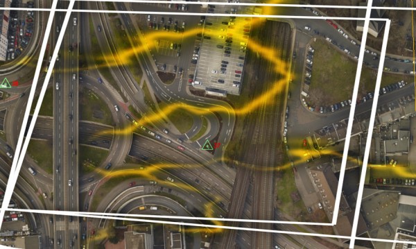
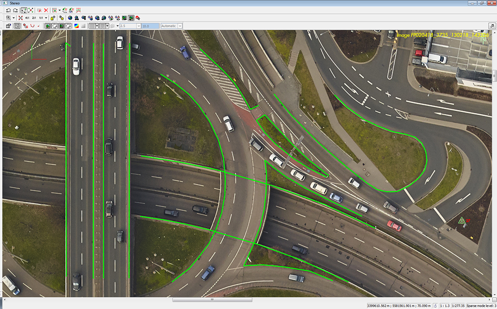
    Inpho version 6.0. Trimble announced a new version of its photogrammetric software suite, which provides highly automated workflows for photogrammetry and remote sensing professionals so they can process thousands of airborne images with high precision. Inpho version 6.0 increases efficiency by reducing project turnaround times and improves the quality of deliverables via new automated and interactive tools and satellite triangulation functionality.

    A new satellite triangulation function in Inpho version 6.0 allows professionals to quickly generate deliverables from satellite imagery data and expand their capabilities, addressing the needs of industries such as environmental, forestry, agriculture and land management. Automatic tie point extraction and bundle block adjustment provides improved orientation of satellite images. The highly automated process results in a significant reduction in office processing time so projects can be delivered with quality precision in a shorter turnaround time.

    Trimble-eCognition-Essentials-Agriculture-Mapping-W Photo: Trimble
    Photo: Trimble

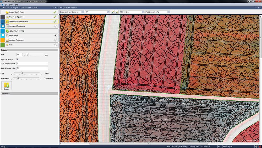
    eCognition Essentials. eCognition Essentials is a new software solution for geospatial and remote sensing professionals performing land-cover mapping tasks using satellite imagery. eCognition Essentials offers an intuitive image analysis solution that allows users of all levels to quickly produce high-quality, Geographic Information System (GIS)-ready deliverables.

    Leveraging core eCognition software technology, eCognition Essentials is easy to use with its simplified and intuitive interface. eCognition Essentials reduces analysis error as it applies predefined and structured rules to analyze and transform imagery data into relevant geospatial information. The new automated image analysis functions — such as image segmentation or sample-based classification — combined with a set of interactive tools for quality control offer users a streamlined workflow for quicker project turnaround times.

    Trident version 7.0 is a new version of the mobile data analysis software designed to efficiently manage, interpret and extract features from digital images and point cloud data collected via land mobile systems. Enhancements in the new version significantly reduce the time required for geospatial professionals to transform land mobile sensor data into relevant geospatial information used in civil engineering, transportation and GIS mapping. In these applications, Trimble Trident can be used for surface modeling, roadway sign and pole detection, lane marking detection, edge and breakline detection, road geometry and clearance measurements.

    Trident version 7.0 offers increased automation functionality to deliver results more quickly. Updated feature extraction tools within the software provide greater reliability and minimize manual editing and verification. Trident version 7.0 breakline detection routines now include a cross-sectional workflow for rapid and progressive development of supervised roadway breakline models.

    Trimble-V10-R8-GNSS-and-Tablet-W Photo: Trimble
    Photo: Trimble

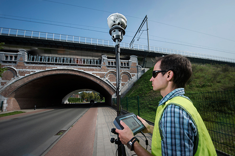
    Trimble V10 Imaging Rover. The Trimble V10 is an integrated camera system that precisely captures 360-degree digital panoramic images for visual documentation and measurement of the surrounding environment. Enhancements include additional integration options and high-dynamic range (HDR) imagery. The Trimble V10 offers an accessible and efficient means of visually documenting site conditions to perform measurements in the office, produce more powerful deliverables and speed up decision making for managers on or off the site.

    In addition to the R10 GNSS receiver, the Trimble V10 Imaging Rover now seamlessly integrates with Trimble’s R-Series GNSS receivers — the Trimble R8, R6 and R4 — and TSC3 controller. Through this seamless integration, geospatial professionals can easily capture high-quality, geo-referenced panoramic images to document the surroundings. Now more Trimble customers can take advantage of the Trimble V10’s powerful capabilities. In addition, a new two-piece power rod option enables easy transportation of the Trimble V10.

  • Visual Intelligence Releases iOne STKA for UAV Mapping Apps

    Visual Intelligence has announced that its iOne Software Sensor Tool Kit Architecture (iOne STKA) is available for purchase or licensing by manufacturers of unmanned airborne vehicles (UAVs) who want to deliver an integrated UAV/geospatial imaging solution to customers.

    Capturing high-resolution imagery for applications in engineering, construction, urban planning, military missions and other uses is a significant emerging market for UAV manufacturers, and Visual Intelligence’s iOne STKA makes it possible to bring high-resolution geospatial sensors to UAVs, the company said. By purchasing or licensing Visual Intelligence’s geospatial imaging platform, UAV companies can meet emerging demand for geoimaging solutions that combine the benefits of UAVs with the imaging capabilities of a geoimaging platform.

    iOne STKA provides the technology foundation to configure a variety of multi-purpose sensors, including miniaturized 2D/3D applications, for the emerging UVS and mobile/handheld markets. The iOne STKA received the Geospatial Forum 2013 World Technology Innovation in Sensors Award, is the first to be considered for NEANY’s Arrow UAV, and is field-proven by the commercial large-format 2D/oblique/3D multipurpose metric mapping systems iOne IMS, iOne Stereo, and iOne n-Oblique.

    With the iOne STKA, the same UAS/UAV sensor system architecture can be used for agricultural and forestry mapping, pipeline or corridor monitoring, utility assessments, aerial surveys, research, persistence surveillance and other metric 2D/3D professional applications. The iOne STKA is a modular multipurpose sensor platform reconfigurable for UAVs of any size. With the iOne STKA, UAV manufacturers are no longer limited to offer monolithic, single purpose DSLR type cameras. Using the iOne STKA technology, UAV end users can economically collect high-quality color or infrared NADIR, oblique, or video imagery as well as co-mount and co-register e.g., LiDAR and thermal sensors using the same system architecture.

    “By providing UAV manufacturers and end-users with one reliable and performing end-to-end standard digital sensor system solution for MANY applications, we are empowering our customers with a more efficient and standard technology foundation and paradigm to grow their business, enhance their products, and maximize their return,” said Visual Intelligence President and CEO Dr. Armando Guevara.

    At the core of the iOne STKA is Visual Intelligence’s Patented Advanced Retinal Camera Array (ARCA). Developed using open systems and object-oriented software engineering principles, the ARCA is “encapsulated” with a rich set of advanced proprietary software methods that integrate camera components. The ARCA enables the collection of different types of imagery, fused in one pass, producing low-cost, extremely accurate, high-resolution products. It also enables unprecedented array-based collection and functional scalability sensor fusion. The arrays made of these varied imaging devices perform like a single camera, producing one single metric, radiometrically and geometrically correct image, or set of co-registered and fused images; such as a Virtual Frame, of higher accuracy, resolution and quality than DSLR-based monolithic cameras.

    Adds Guevara, “UAV manufacturers can take advantage and offer bundled with the iOne sensors Visual Intelligence’s advanced computing technology for fast cloud-based basic and advanced actionable information product generation. As a fully automated solution (from the sensor to the cloud), the iOne STKA includes processing software that uses streamlined workflows and processes imagery faster with multicore/multithreaded/GPU computing technology, making it easy to quickly produce and analyze products in a device-content eCosystem environment. This technology/business model is designed to provide UAV manufacturers and users recurrent ROI.”

    UAVs built using sensors based on the iOne STKA have the following features and advantages:

    • Strong digital obsolescence resilience, extending the useable life of the system while improving operational efficiencies and reducing operating costs for an even better ROI.
    • In the field:
      • Collection scalability
      • Functional scalability
      • Sensor reconfiguration, e.g. increase collection or functionality as needed or per mission requirements.
    • Large cross-track and FOV collection through smaller aperture (ARCA enabled).
    • Ability to collect different sources of metric imagery that can be fused in one pass.
    • Sensor fusion: Ability to co-mount and co-register in a “small and tight packaging” the EO capability with any other EO or active sensor such as LiDAR, Thermal, IR, etc.

    The iOne STKA software architecture is normative across all ARCA-based products; that is, the software is the same for different array configurations or sizes. This reusable component approach yields economies of scale in the manufacturing and use of multipurpose UAV/sensor configurations.
  • GeoEye Signs Two New Seven-Figure GeoEye-1 Imagery Contracts

    GeoEye, Inc. announced that it recently signed seven-figure agreements with two international partners in the Middle East and Asia for both the renewal and expanded use of GeoEye imagery products.

    According to the announcement, the Middle East affiliate has signed a new agreement for access to GeoEye-1 sub half-meter imagery, which is the highest resolution commercial imagery available globally. This affiliate has had an ongoing agreement with GeoEye for IKONOS satellite imagery collection and distribution since 2000. The agreement with the government customer in Asia renewed their access to GeoEye-1’s highly precise imagery products. This customer has had an agreement in place for GeoEye-1 satellite imagery collection since 2009. Both partners have indicated they will integrate GeoEye-1’s high-resolution imagery with their own systems to support regional security and peace missions.

    “Both the Mideast Regional Affiliate and the Asian government customer have been trusted and valued partners for many years,” said Paolo Colombi, GeoEye’s vice president of International Sales. “We appreciate the extension of our partnerships and the expansion of our global footprint that these agreements represent. We look forward to supporting our partners’ mission critical requirements by delivering superior-quality location intelligence regarding these highly sensitive and dynamic regions of the world.”

  • DigitalGlobe Expands Imagery Solutions for Oil and Gas

    DigitalGlobe has unveiled ImageConnect: Oil and Gas, an online imagery service with on-demand access via GIS and Web mapping services to areas of global oil and gas exploration. Built upon DigitalGlobe’s standard ImageConnect solution, ImageConnect Oil and Gas provides imagery of geographic areas important to upstream oil and gas exploration, including oil basins, refineries, pipelines, and geological areas of interest to the oil and gas industry.

    ImageConnect: Oil and Gas provides online access to a 1 million square kilometer global image layer of high-resolution satellite-imaged oil basins. With DigitalGlobe’s content collection strategy for identifying and gathering high-interest areas around the world, ImageConnect Oil and Gas will have new images added regularly from DigitalGlobe’s constellation of highly accurate, sub-meter satellites.

    “Our world imagery solutions affect oil and gas professionals’ view on location decisions, by bringing within their reach, both economically and geographically, premium imagery for monitoring and exploring oil fields and facilities,” said Marc Tremblay, senior vice-president and general manager of DigitalGlobe’s commercial business unit.

    “By accessing our advanced imagery online, oil and gas enterprises can increase their visibility into potential expansion areas, select the best location for infrastructure placement in remote and rugged terrain, and quickly monitor facilities and reclamation areas by reducing the time and operational costs associated with onsite monitoring and surveying.”

    With a subscription to ImageConnect, GIS professionals can connect directly to DigitalGlobe’s global online image library for country- or industry-specific areas of interest through plug-ins for major desktop mapping software applications, including ESRI ArcGIS, MapInfo Professional, Autodesk Map 3D, or any WMS-enabled client.