Tag: hydrographic survey

  • Satlab Offers Hydrographic Echo Sounder for GNSS Rover

    Satlab Offers Hydrographic Echo Sounder for GNSS Rover

    Photo: Satlab Geosolutions AB

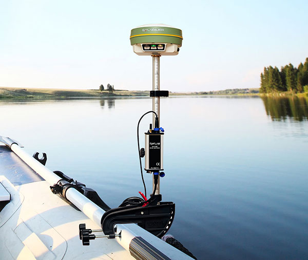
    Swedish-based Survey and GIS equipment maker Satlab Geosolutions AB has announced the availability of its SLD-100 GNSS Rover accessory to facilitate Hydrographic measurement in bodies of water up to 100 meters in depth. It is designed for those who find themselves needing to survey into bodies of water, streams and rivers.

    Photo: Satlab Geosolutions AB
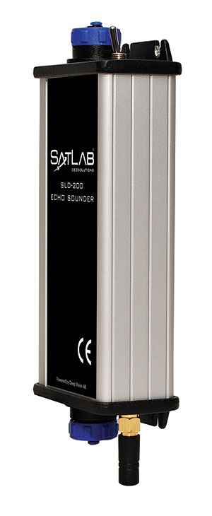
With survey-grade accuracy, the Satlab SLD-100 can be added to any brand GNSS RTK Rover to allow for position and depth measurements to be made simultaneously. With a built-in 10-hour lithium battery and transmitter unit with Bluetooth connectivity, the SLD-100 provides standard depth data streams in several industry standard NMEA formats at 1Hz, 4800 bps, providing compatibility with any hydrographic surveying software package.

    “Our new SLD-100 survey receiver is extremely easy to use with position and depth information externally logged on a computer or controller,” said Birol Güçlüer”, CTO and partner of Satlab. “With the included transom mounting hardware, installation is quick and easy.”

    The SLD-100 is available now for a suggested retail price of US$2995.

  • NovAtel Adds Commercially Exportable IMU-KVH1750 to SPAN GNSS Line

    NovAtel Adds Commercially Exportable IMU-KVH1750 to SPAN GNSS Line

    NovAtel's iMU-KVH1750.
    NovAtel’s iMU-KVH1750.

    NovAtel, Inc., has added the IMU-KVH1750 as an inertial measurement unit (IMU) option in its SPAN GNSS/INS line of positioning products. The IMU-KVH1750 is a high-performance commercial off-the-shelf (COTS) sensor that offers excellent bias stability and repeatability, NovAtel said. It incorporates KVH’s DSP-1750 precision fibre-optic gyro with very low noise MEMS accelerometers.

    Commercially exportable, the IMU-KVH1750 integrates easily with NovAtel’s OEM6 series of receivers to provide a tightly coupled 3D navigation solution, the company said. Offering customers continuous position, velocity and attitude (roll, pitch and azimuth) measurements, a SPAN system is stable and available even through periods when satellite signals are blocked or unavailable.

    The IMU-KVH1750 supported SPAN system is designed for mobile and airborne mapping applications as well as hydrographic survey. It can be relied on to provide accurate, continuous performance in harsh environments, and features excellent shock vibration and thermal functionality.

  • Hemisphere GNSS Vector Products Now Have GLONASS Functionality

    Hemisphere GNSS has announced that all professional-level Vector products — including the V103, V113, VS131, and VS330 — now include the ability to utilize the GLONASS system along with GPS in the navigation solution. The tracking of the additional GLONASS signals provides a more robust solution, especially in challenging environments, the company said.

    Vector Technology processes L1 GPS and GLONASS signals to deliver precise heading, greater positioning reliability, and improved performance in challenging environments. Hemisphere GNSS’ patented Vector technology computes the heading and pitch or roll angle while stationary or in motion allowing for heading accuracy of up to 0.01 degrees depending upon the product selected. A variety of differential correction methods also make it possible for Vector products to provide sub-meter to centimeter level RTK position accuracy.

    Professional marine industry organizations can maximize performance by integrating Hemisphere GNSS Professional Vector technology into their systems for hydrographic and bathymetric surveys, autopilots, dredging, and buoys. For land applications, Vector Technology is designed for the alignment of cameras, antennas, and projectiles, and for machine control applications in agriculture, construction, and mining.