The latest versions of Ekinox, Apogee, and Navsight from SBG Systems are now fully compatible with the Fugro Marinestar G4+ precise point positioning (PPP) solution.
Fugro Marinestar G4+ is a solution that uses satellite-based augmentation to deliver centimetric positioning accuracy without depending on a local base station. This product is suitable for maritime operations where precise positioning is important.
With this compatibility, users can now use Marinestar correction with SBG products both via L-Band or NTRIP distribution.
The combination of high-performance correction with inertial measurements from SBG Systems enables users to achieve accuracy in attitude and position for maritime applications. This is suitable for applications such as marine construction, dredging, hydrography and more.
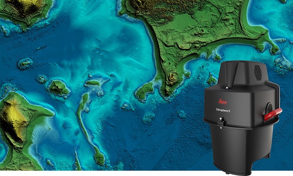
The new Leica Chiroptera-5 is a high-performance airborne bathymetric lidar sensor for coastal and inland water surveys.
Offered by Leica Geosystems, Chiroptera-5 provides 40% higher point density, a 20% increase in water-depth penetration, and improved topographic sensitivity for generating more detailed hydrographic maps.
The technology increases the depth penetration, point density and topographic sensitivity of the sensor compared to previous generations. It delivers high-resolution lidar data supporting applications such as nautical charting, coastal infrastructure planning, environmental monitoring and landslide and erosion risk assessments.
Chiroptera-5 combines airborne bathymetric and topographic lidar sensors with a four-band camera to collect seamless data from the seabed to land. With a higher pulse repetition frequency (PRF), the new technology increases point density by 40% compared to the previous generation system, collecting more data during every survey flight.
Improved electronics and optics increase water-depth penetration by 20% and double the hydrographic sensitivity to capture larger areas of submerged terrain and objects with greater detail. The high-performance sensor is designed to fit a stabilizing mount, enabling more efficient area coverage, which decreases operational costs and carbon footprint of mapping projects.
Leica Geosystems’ signature bathymetric workflow supports the sensor’s performance. Introducing near real-time data processing enables coverage analysis immediately after landing, allowing operators to quality control the data quickly before demobilizing the system.
The Leica Lidar Survey Studio (LSS) processing suite provides full waveform analysis and offers automatic calibration, refraction correction and data classification, as well as advanced turbid water enhancement.
Supporting environmental research
Combining superior resolution, depth penetration and topographic sensitivity, Chiroptera-5 provides substantial benefits for various environmental applications such as shoreline erosion monitoring, flood simulation and prevention, and benthic habitat classification.
Bundled with the FAAS/EASA-certified helicopter pod, the system enables advanced terrain-following flying paths for efficient river mapping and complex coastlines surveys. Owners of previous-generation systems are offered an easy upgrade path to Chiroptera-5 to add capabilities to their existing sensor and leverage their initial investment.
“The first-generation Chiroptera airborne sensor was flown in 2012. During its 10 years of operation, the system has seen constant evolution that continuously improved the productivity and efficiency of the entire bathymetric surveying industry,” said Anders Ekelund, vice president of airborne bathymetry at Hexagon. “By collecting detailed data of coastal areas and inland waters, Chiroptera-5 provides an invaluable source of information that supports better decision making, especially for environmental monitoring and management, in line with Hexagon’s commitment to a more sustainable future.”
The Horizon fiberoptic gyro (FOG) inertial measurement unit (IMU) now forms part of SBG Systems’ Navsight Marine Solution, dedicated to hydrographers. Navsight is available at different levels of accuracy to meet the various application requirements and can be connected to various external equipment such as echo-sounders, lidar, and so on.
Photo: SBG Systems
Navsight Marine Solution already offered two levels of performance with the Ekinox and Apogee IMUs. These MEMS-based IMUs address most of hydrographics markets whether shallow or deep water.
The new Horizon IMU enables customers to deploy Navsight in the most demanding environments such as surveying highly dense areas (bridges, buildings, and so on) as well as applications where only a single antenna can be used.
The Horizon IMU is based on a closed-loop FOG technology which enables ultra-low bias and noise levels. This technology allows robust and consistent performance even in low dynamics survey.
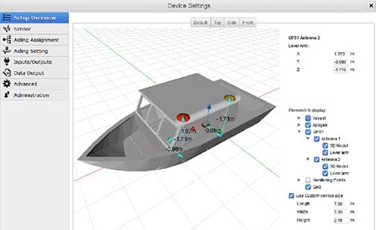
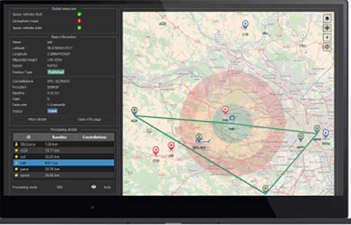
Navsight solution is easy to install, as the sensor alignment and lever arms are automatically estimated and validated. Once connected to the Navsight processing unit, the web interface guides the user to configure the solution. A 3D view of the vessel shows the entered parameters so that the user can check the installation. The Navsight unit also integrates light emitting diode (LED) indicators for satellite availability, RTK corrections, and power. It comes with a rugged enclosure, or in a rack version for larger vessels.
Completing the Navsight offer, Qinertia, SBG’s post-processing software, gives access to offline RTK corrections from more than 7,000 base stations located in 164 countries. Trajectory and orientation are then greatly improved by processing inertial data and raw GNSS observables in forward and backward directions. Computation takes less than 3 minutes for a 6-hour log thanks to the Forward and Backward calculation processed at the same time.
While not as glamorous as mild-mannered Clark Kent holding down a day job while Superman comes to the rescue in time of crisis, there are professional surveyors who work day jobs to perform our duties as practitioners to make a living and participate in association activities in their off-hours to help promote and protect their profession as well as the public they serve.
Many of the hours spent to protect the profession are in the political arena, where the battle for budget dollars and service rights are fought on nearly a daily basis. Because of the reliance of the surveyor on technological advances, the profession has been thrust into the political arena at all legislative levels. The surveyor has been tasked with leading the discussion and help the public understand why significant dollars are needed for funding many different programs to continue with our high-tech trends and lifestyles.
Three of the four presidents on Mount Rushmore started as surveyors — George Washington, Thomas Jefferson and Abraham Lincoln. (Photo: National Park Service)
The role of the surveyor has not been considered political even though several significant U.S. presidents were surveyors in their early careers. Surveyors aren’t particularly known for their public personas, much less their political prowess. Other than states that still have county surveyors, rarely do practitioners stray beyond local municipal government. One is more likely to see a professional engineer or architect as an elected official than a surveyor, but that doesn’t mean the issues we face are any less important.
My current position is a professional land surveyor with a full-time job overseeing a department in a multi-discipline office in a major metropolitan area. Besides being a contributing editor to GPS World through these articles, I also voluntarily wear many hats within our state association and the national surveying society. Several of these hats are government affairs positions at both state and federal levels, as it has become a full-time operation to keep a watchful eye at all governmental levels. From changes in regulations, budgetary revisions and threats to our professionl by outside entities, government affairs take a small army of people to keep abreast of all situations.
This month’s submission is just a snapshot of the current National Society of Professional Surveyors (NSPS) Joint Government Affairs Committee action item list being addressed and monitored through its committee members and a governmental lobbyist. The importance of this list is to give the reader a sampling of the seemingly endless battles being waged on Capitol Hill by NSPS and its members nationwide.
All these issues have GNSS at their heart and will have dire consequences if any of these subjects fall short of their intended marks.
This is not just about the GNSS and how we collect data; it’s also about the necessity of large scale data collection to provide better and safer services to the citizens of the United States and its territories.
Our current datasets and standards for data collection, like our infrastructure, is aging and lacking in detail. Serious upgrades are overdue, so several actions have been put forth to try to rectify the shortcomings.
3DEP
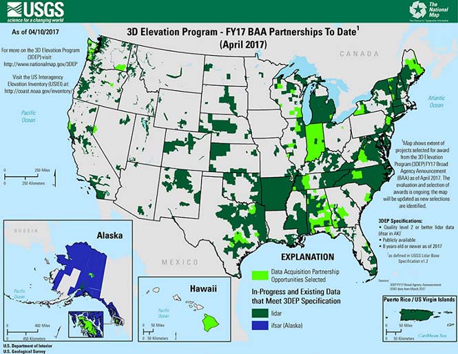
Formally known as the 3D Elevation Program, this language was introduced as part of S. 1460 (“Energy and Natural Resources Act of 2017”) by Senator Lisa Murkowski of Alaska. This program is being created so that consistent elevation data, cultivated through many surveying and mapping sources including lidar, will be available for efficient design use throughout the American infrastructure.
While it currently does not have a single line item in any budget, the USGS Budget Summary lists its necessity in the Core Science Systems Program as part of the National Geospatial Program. This program is intended to provide high-quality topographic, geologic and hydrographic data nationwide to assist with further development of energy, transportation, drainage, emergency response and hazard mitigation.
As part of the 2019 President’s Budget, the USGS Green Book also lists having the entire nation covered by an ongoing lidar program by 2033, along with completing a significant amount of data collection by various means in Alaska by 2022, including high-resolution interferometric synthetic aperture radar (IfSAR) necessary for data collection in more difficult terrain.
The Green Book also lists high-resolution hydrographic data to support flood risk management studies, as the frequency of large scale flooding seems to be increasing substantially in more places than ever before. It also includes additional mapping data, programming and functionality for emergency personnel charged with oversight of public safety in times of crisis.
FAA reauthorization
The current FAA authorization bill expires on March 31. The biggest hang up holding up getting the bill reauthorized is privatization of the air traffic controllers, but there are rumors of tightening of UAV rules due to the rapidly growing use of the vehicles for business and personal use.
Surveyors are working with federal and state officials to help implement reasonable rules for use and coverage of the UAV as the field of surveying has been drastically affected by use of aerial vehicles. Many tasks that used to take days now take hours with increase accuracy, so the effects of the UAV will be seen for many years to come.
Digital Coast Act
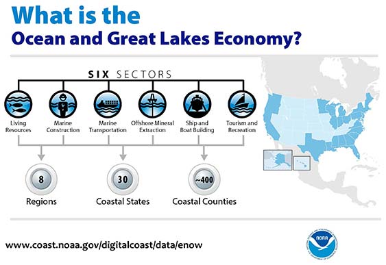
One of the legislative acts that NSPS was a big part of in 2017 was Senate Bill 110, “The Digital Coast Act” which led to the introduction of the companion bill in the House as H.R. 4062. This Act will allow NOAA to perform the necessary actions to actively and effectively monitor all coasts (including the Great Lakes) by various means, including bathymetric and conventional survey methods. This will require services to be performed by public and private surveyors primarily with GNSS capability to provide NOAA with standardized information based upon established datum.
FLAIR Act
The Federal Land Asset Inventory Reform (FLAIR) Act of 2017 was introduced as House Resolution 2199 to help with creating a database of government property nationwide. The Government Accountability Office (GAO) has stated that the management of federal real property has become a “high-risk” item on its list of duties. Management of the number and value of properties has increased to a point that an overall dollar amount of federal buildings and land cannot be accurately determined.
How does the surveyor fit in with this issue? Simple. The U.S. government will need to upgrade its database of existing facilities through having them surveyed for asset management. Part of the requirements for providing these surveys will be completing the work in datums that will be following the geographical databases being designed to contain the parcel and building information. All this data will have geospatial information regarding parcel, address, utilities and functionality of the inventory, so providing the data with the sufficient attributes will become a key role for the surveyor. GNSS data collection will be at the heart of this monumental task.
Geospatial Data Act
As introduced in May 2017, the Geospatial Data Act (GDA) of 2017 is intended to jumpstart the nationwide initiative to develop and coordinate efforts to collect and maintain new datasets of elevation and infrastructure information. It is intended to improve and enhance federal geospatial activities to encourage state and local agencies to participate at the local level.
It is interesting to note, however, that the revised Geospatial Data Act was introduced by the same sponsors that did not include procurement procedures that follow the typical Brooks Act of quality-based selection, and instead relied on bid-based selection commonly found with suppliers. Both bills are being vetted by their sponsors and potential geospatial providers for clarity with ongoing debate going forward.
Hydrographic Services Improvement Act
H.R. 211 bring us the Hydrographic Services Improvement Act to provide NOAA with incentive and funding to standardize surveys desperately needed in waterway areas. Ongoing discussion continues this spring to determine sources of funding and priority of projects.
Infrastructure bill
February brought us the introduction of a significant infrastructure program aimed at improving roads, airports and bridges, with other major improvements across the country. This program is noteworthy in recognizing the need of current geospatial data and inventory of major infrastructure needs. The program sets forth the need for surveying, mapping and geospatial data for planning, design, construction, operations and maintenance for a multitude of projects nationwide. Much more will be discussed regarding the funding and priority of projects as the political year moves on.
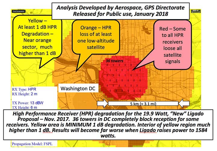
LightSquared/Ligado
Readers may remember when the original confrontation with LightSquared began in 2011, and the subsequent battle over the frequency ranges adjacent to the GPS bandwidth. The FCC gave LightSquared initial but conditional approval to move forward with terrestrial-based transmission for 4G cellular transmission for up to 40,000 land-based stations. Testing by private and governmental agencies through 2011 and 2012 proved that LightSquared would greatly harm GPS activity for both public and private use. Once exposed, the conditional FCC approval was rescinded and LightSquared retreated into the shadows…until now.
Reformed as Ligado, it has fresh investors and is making a charge into 5G technology with a revised game plan. While it is also looking to use other spectrums for communication, it once again is dangerously close to other current uses. Couple the proximity of adjacent bandwidth with the intense land-based signal versus a very weak satellite signal, there will be significant overriding by the new user. All of this is still being worked out through the FCC and the Department of Defense, so final resolution is yet to be seen.
IMAGES Act
The National Flood Insurance Program (NFIP), as part of FEMA, is looking to move forward with legislation introduced as Improvement of Mapping, Addresses, Geography, Elevations and Structures (IMAGES) Act (H.R 4905). This act intends to reform the NFIP program by utilizing new elevation data collected through the 3DEP program, which will be combined with other parcel attributes including addresses and structure types. This data will then be combined with refined floodway information to identify parcels that are more susceptible to damage caused by storms and flooding.
New legislation can be a good thing, but only if funding can be provided. This bill could provide a major upgrade to the flood mapping and insurance program, but it will hit a big snag with lack of monetary support. The proposed funding for FY2019 is $100 million, yet the project costs for the FY2018 budget is $178 million. This significant difference will make a large impact on the effectiveness of the program and proposed revamp.
Railroad reauthorization
NSPS has spent several years working with various legislators trying to find the right bill to insert language to require railroads to monument their routes before removing tracks. But with the recent accidents of various rail lines, the spotlight has been put on various factors that cause the incidents and how to eliminate their occurrence.
Positive train control (PTC) systems incorporate geospatial data collected through GNSS, lidar and conventional surveying means to work with operational systems to assess dangerous situations. Surveyors will need to be at the forefront of the necessary data collection so our efforts to continue lobbying for railroad funding will continue.
Net Neutrality Act
A political hot topic the surveyor doesn’t typically think about is net neutrality. Most people think they will be affected by lack of neutrality slowing down their home internet or streaming service, but for surveyors it will be a much bigger deal.
A remarkable number of surveyors and mappers use cellular data streaming to provide a connection to a positional correction service. The throttling of this data will effectively slow down the performance and quality of the positional data, leading to less reliability and productivity. It will also slow down the data interaction of office and field staff exchanging data and image files critical to project productivity and success.
So, when the call goes out to contact your federal representative to protect net neutrality, remember how it will affect your surveying business model and make that call.
How professional land surveying associations get it done
Many thanks to the countless hours put in by the NSPS Joint Government Affairs team, consisting of Committee Chair Pat Smith, NSPS Government Consultant John Palatiello, NSPS Federal Lobbyist John “JB” Byrd and NSPS Executive Director Curt Sumner. This group is constantly monitoring legislative action across the country as well as in D.C. and is quick to respond when action is needed on legislative issues. They do a tremendous job, yet not many see them in action. Hopefully all surveyors will continue to see and feel the benefits of their results.
As simple as the process is, the political world has gotten much more complicated as time marches on. From local municipal offices to Washington, D.C., getting things done through legislation has become a long process that takes patience and plenty of money to get your voice heard. Surveyors are no different than any other profession in that we must stay out in front of issues that affect our physical and business world. The important part is to stay informed and have a voice.
Let’s also remember those three fine individuals, memorialized on Mount Rushmore, who accomplished great things after their stints as surveyors, so anything is possible if we keep our voice in government.
Surveying has evolved into a highly technical professional with GNSS as a backbone method of data collection. With the U.S. government at the center of that technology, we need to make sure we, as the surveying practitioner, stays engaged.
GEO Business, the United Kingdom’s largest geospatial exhibition and conference, has announced that registration is now open.
The GEO Business show has grown every year since its inception, and the 2018 show looks set to be the most successful show to date with more exhibition space and a brand new seminar program. The event will return to the Business Design Centre, in London, UK, May 22-23.
Since its record-breaking 2017 event last year, which welcomed 2,386 geomatics and geospatial professionals from around the world (a 48 percent increase since the launch in 2014), the exhibition has expanded onto the upper level. Exhibitors span the entire geospatial industry, showcasing cutting-edge technology and solutions that will mold the future of the industry.
The 2018 GEO Business show will expand to the second level of the Business Design Center. (Photo: GEO Business)
Confirmed exhibitors for 2018 include Survey Solutions Scotland, Land Registry, GAP Group, Phase One, Viametris, Surphaser/ MD3D, DHF Satellite and Ordnance Survey Ireland.
New for 2018 is a free-to-attend seminar program designed to demonstrate the remarkable impact geospatial technologies and solutions on the global environment. The program will feature case studies from companies demonstrating how they are reducing costs and risk while increasing productivity.
The 2017 GEO Business exhibit. (Photo: GEO Business)
The latest in augmented reality, building information management (BIM), geospatial information systems (GIS) and big data, laser scanning, mobile mapping, remote sensing and satellites, smart cities, surveying, UAVs, virtual reality and visualization will feature within the fields of architecture and construction, commercial property, environmental, equipment theft, floods, forestry, heritage, highways, hydrography, mining, rail and tunneling.
With geospatial technology now impacting on more and more industries, GEO Business is attracting visitors from a wider range of industry sectors than ever before.
“The geospatial industry is experiencing a huge transformation, everywhere you look at the moment you bare witness to the term ‘geospatial,’” Show Director Caroline Hobden said. “Innovative technology is steadily making its presence known in everyday life, whether it is through the revolutionary capabilities of augmented/virtual reality or the extraordinary data recorded by drones to name just a few, the world is sitting up and taking notice.
“Even the U.K. government budget made mention of geospatial at the end of last year and as a result we excitedly await further announcements about the Geospatial Commission whose focus will be on location aware technologies revolutionising the digital economy.”
The exhibition and seminar program will run alongside a strategic senior-level conference of invited speakers presenting and debating the role of geospatial in powering the Fourth Industrial Revolution, said GEO Business. The Fourth Industrial Revolution is changing how we live, work and communicate. It is reshaping government, education, healthcare and commerce — almost every aspect of life. The conference will celebrate, challenge and develop the role that geospatial has to play in maximizing the digital economy as part of this revolution.
Visitors will also have the unique opportunity to attend the well-established commercial workshop program hosted by exhibitors demonstrating their latest products and services and a full line-up of innovative social activities designed for informal networking with colleagues old and new.
The exhibition, workshops and seminars are free to attend. There is a fee-to-attend the conference with an early-bird discounted rate for registrations before April 16. Public sector, association members and student discounts are also available. Visitors are encouraged to register online in advance to beat the queues onsite.
For more information on stand sales or visitor registration, contact Caroline Hobden at [email protected] or call +44 (0)1453 836363.
SBG Systems has released a new generation of its advanced and compact inertial navigation systems. The Ekinox 2 series features new accelerometers and gyroscopes, enhancing attitude accuracy by a factor of two over the original Ekinox.
Photo: SBG
The Ekinox series is a line of tactical grade MEMS-based inertial navigation systems, first released in 2013. The latest improvements come from a complete redesign of the in-house inertial measurement unit (IMU), integrating cutting-edge gyroscopes and accelerometers.
With higher accuracy for the same form factor and price level, Ekinox 2 Series is designed for industrial-grade vehicle navigation, equipment motion compensation and data georeferencing. It provides a 0.02-degree roll and pitch, 0.05-degree heading and a centimeter-level position.
Applications for the Ekinox 2 include hydrography, mobile mapping and antenna tracking. With new accelerometers, this new generation has also significantly improved its resistance to vibration. Finally, the addition of the BeiDou constellation improves signal availability in Asia.
Compact and light-weight, the Ekinox Series has been designed to simplify installation operations. Configuration is made with an intuitive embedded web interface where all parameters can be displayed and adjusted. For example, users can choose a profile (vessel, plane, car, etc.), and the 3D view will provide a visualization of settings such as the sensor position, alignment and lever arms.
The Ekinox 2 Series is ITAR Free. The product line will be available during the second quarter of 2017.
GNSS Survey & Engineering, a 238-page primer for the professional user, has just been published by Geomares. Four opening chapters deal with the general layout of GNSS, its errors and its practical use. Geared to the everyday professional GNSS user, this section does not give in-depth theoretical background. The second group of four chapters discusses topics such as geodesy, satellite signals and positioning theory. Filling in the background of subjects in the first part, this section is aimed at the more specialized professional user or student who needs an in-depth knowledge of GNSS positioning.
This is the second edition of the book by Huibert-Jan Lekkerkerk. The book is based on lectures the author has written for Skilltrade, an online training site, as well as a series of articles on satellite navigation systems. Lekkerk has bachelor’s degrees in hydrographic surveying and maritime electronics and a Master’s degree in geographic information management. He works in hydrography and on the standardization, analysis, processing and dissemination of geographic data for the Dutch government.
The membership of the Open Geospatial Consortium (OGC) seeks public comment on its WaterML 2 – Part 3, Surface Hydrology Features Conceptual Model.
The OGC WaterML 2 – Part 3, Surface Hydrology Features Conceptual Model (HY_Features) is part of an intended ‘OGC WaterML 2’ suite of standards that groups water-related OGC standards. The candidate standard follows Part 1: Timeseries, and Part 2: Ratings, Gaugings and Sections.
The candidate HY_Features standard defines a common feature model for the identification and description of surface hydrologic features. The feature model is based on established models and patterns in use in the Hydrology domain and endorsed by WMO and UNESCO, such as those documented in the “International Glossary of Hydrology.”
The candidate HY_Features standard also defines a common conceptual information model for surface hydrologic features independent of their geometric representation and scale. The model describes fundamental relationship types that exist among major components of the hydrosphere. This includes relationships such as hierarchies of catchments, segmentation of watercourses, and topological connectivity of hydrologic features based on the flow and conservation of water.
The standard is intended to be used to document and share information about real-world objects that are studied in a wide range of hydrologic study types. The original design goal for HY_Features was to link hydrologic information across the scientific and technical programs of organizations with local to global scope, and to assist in discovery, access, and use of hydrologic data from different sources.
The HY_Features model is designed to support many types of hydrologic information and sub-disciplines. The model supports referencing information about a hydrologic feature across disparate information systems or products, thereby improving data integration within and among organizations.
Similarly, the model can be applied to cataloging of observations, model results, or other study information involving hydrologic features. The ability to represent the same catchment, river, or other hydrologic feature in several ways is critical for aggregation of cross-referenced or related features into integrated datasets and data products on global, regional, or basin scales.
Agreement on common concepts and methods is necessary to enable semantic interoperability of hydrologic data and services. The HY_Features model was developed in order to formalize concepts and relationships of hydrologic and hydrographic features using the WMO/UNESCO “International Glossary of Hydrology” as a starting point.
Dewberry, a privately owned professional services firm, has completed the National Hydrography Requirements and Benefits Study (HRBS) for the United States Geological Survey (USGS).
The firm conducted the study — sponsored by USGS and the U.S. Department of Agriculture’s Natural Resources Conservation Service — to establish a baseline understanding of national business uses, needs and associated benefits for national hydrography data and to inform the design of an enhanced future program that balances requirements, benefits and costs.
Dewberry collected more than 400 responses from federal agencies; commissions; non-profits; private and commercial entities; and local, state, and tribal governments from across the 50 states, Washington, D.C., and American Samoa.
Participants were asked to provide detailed information about the hydrography data required to accomplish their missions, including positional accuracy, stream density, smallest contributing watershed, smallest mapped body of water, update frequency, post-event updates and level of detail. They were also asked what analytical functions and integration levels are required between hydrography data and other datasets.
Dewberry collected responses regarding hydrography data access methods, including required data types or formats, geographic extents, data or service access methods, required elevation-hydrography data integration, and the impact of hydrography data errors.
Study respondents reported budgets associated with annual programs supported by hydrography data and what future annual benefits they anticipate from an enhanced data program.
“Hydrographic data is integral to a variety of mission-critical activities performed throughout the U.S.,” said Dewberry associate and project manager Sue Hoegberg. “Our report gives USGS a far greater understanding of the requirements and benefits associated with potential enhancements to a national hydrographic data program, one that — if all reported requirements were met — would help users realize an estimated $602.5 million in annual program benefits.”
Based on Dewberry’s results, the top business uses of hydrographic data are to manage river and stream flow, riverine and stream ecosystems, water resources, flood risks and wildlife and habitat, as well as track water quality — six uses that account for $545 million of the estimated future annual benefits.
The top requirements for integration with other datasets are elevation, stream flow, wetlands, soils and land cover.
President Obama’s trip to Cuba this week marks a historic milestone in the normalization process between the U.S. and Cuba. At the same time, the two countries are working to improve maritime navigation safety and related areas of mutual interest to protect lives and property at sea.
Ambassador Jeffrey DeLaurentis, the chief of mission at the U.S. Embassy in Havana, and Col. Candido Alfredo Regalado Gomez, chief of Cuba’s National Office of Hydrography and Geodesy (ONHG), signed a Memorandum of Understanding (MOU) on maritime navigation.
The MOU calls for cooperation in the areas of hydrography, oceanography, geodesy and related services of mutual interest. One of the major focuses will be to improve maritime navigation safety including efforts to ensure the accuracy of both electronic and paper charts, eliminate charting overlaps and fill in gaps in navigational chart coverage.
In addition to updating data on domestic charts like the NOAA chart above, the U.S. and Cuba agreed to work together on a new international paper chart which will cover south Florida, the Bahamas and northern Cuba. (NOAA)
In February 2015, less than two months after President Obama announced the United States’ new approach toward Cuba, the National Oceanic and Atmospheric Administration (NOAA) and the ONHG, through a set of reciprocal exchanges, launched what became a year-long effort to formulate the technical exchange that is a normal course of affairs between most of the other maritime nations of the world. Both agencies are working on plans for monitoring and forecasting tides and currents for ports and improving positioning networks among other related scientific and technical activities.
“NOAA has a strong interest in both improving navigational safety and in protecting the marine environment in the heavily travelled and vibrant waters between our two countries in the Straits of Florida,” said Russell Callender, Ph.D., assistant NOAA administrator for the National Ocean Service. “We welcome this agreement and the progress it represents.”
“Improved navigation services are important for commercial mariners and individual boaters alike,” said Ambassador DeLaurentis, “and it is particularly important as authorized trade and authorized travel increase between the two countries.”
“This MOU will allow us to fill gaps in essential navigational data, working on a practical level with our Cuban counterparts,” said Kathryn Ries, deputy director of NOAA’s Office of Coast Survey. “The U.S. works with hydrographic offices of all nations that have waters adjacent to the United States and our territories, and this agreement improves the exchange of charting information with Cuba as well.”
The MOU is the first step in what is expected to be a long-term collaboration between the two countries.
In addition to aligning each country’s navigational charts, NOAA and ONHG are sharing data for the creation of a new international chart (known in mariner’s parlance as “INT chart”) 4149, which will cover south Florida, the Bahamas, and north Cuba. NOAA plans to publish the new chart this year.
A new high-accuracy technique using one dual-frequency GNSS receiver, precise point positioning (PPP) offers the possibility of cost-effectively obtaining coordinates. This study investigates the accuracy of kinematic PPP for hydrographic applications on rivers, and shows results comparable to double-difference solutions.
By Ashraf Abdallah and Volker Schwieger
Duisburg Harbor, Germany: site of the PPP survey.
Precise Point Positioning (PPP) is a challenging surveying technique for high-accuracy results. It offers the advantage of using one dual-frequency GNSS instrument. Estimation of a PPP solution is based on the ionosphere-free linear combination for code data and carrier-phase data.
Bernese Software. Bernese software V. 5.2 is a GNSS post-processing software, using GNSS measurement data for static and kinematic surveying. It processes the data in double-difference (differential GNSS) and zero-difference (PPP solution) techniques. The software was developed at the Astronomical Institute of the University of Bern.
Bernese software contains a group of different tools or programs to complete the processing for double-difference or zero-difference mode. The estimation of the two techniques has the same processing schedule in most of the pre-processing stages. The change appears later within the parameter estimations section.
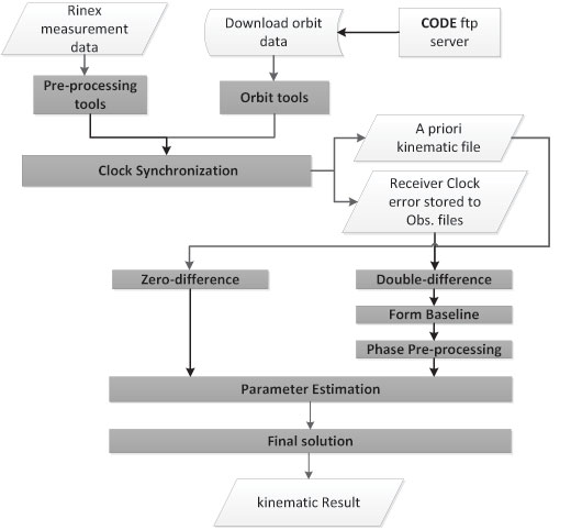
As shown in Figure 1, the processing starts with downloading the related orbits from the CODE (Center for Orbit Determination in Europe) FTP server. The orbit tools include the updating of the Earth orientation parameters to be in Bernese format, converting the satellite data to a specific format and generating the standard orbit format for Bernese software. A preprocessing program contains the smoothing of the RINEX data from outliers and cycle slips.
Figure 1. Bernese software processing schedule.
This smoothing step is following by converting the RINEX into Bernese binary format. The receiver clock is synchronized with respect to the GPS time and stored to observation files using clock synchronization tools. Using the code solution, a kinematic file is written to be inserted in the next parameter estimation procedure. For double-difference solution, a baseline is created, and this baseline is corrected from cycle slips for phase data. Parameter estimation is carried out by least-square estimation for the phase and code GNSS observations.
Kinematic PPP Solution. Bernese software provides the possibility to obtain the PPP solutions in automatic script (Bernese Protocol Engine [BPE]). The satellite orbit and clock ephemeris data from CODE center were used with intervals of 5 seconds to obtain highly accurate results. Satellite and receiver phase center offsets are considered. Tropospheric correction is applied using the Global Mapping Function (GMF) model for the hydrostatic and wet delay estimation. Regarding ionospheric correction, the estimation of the PPP solution is based on the linear ionospheric-free combination, with high-order ionospheric parameters to improve the estimation.
The ocean tidal loading correction is considered in the PPP estimation. Atmosphere tidal loading is also corrected.
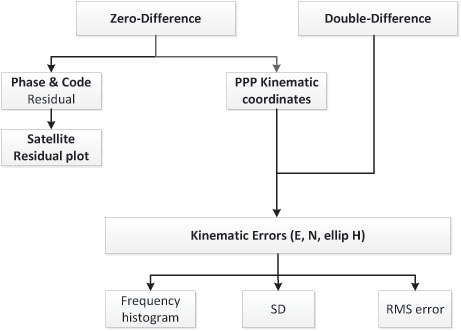
Figure 2 gives the analysis flowchart. Some outputs of the PPP solution could be visualized, such as the satellite phase and code residuals. The high residuals might come from the lower elevation angles of the satellites. Moreover, the residuals appear because of the effect of the remaining observation errors, such as atmospheric delay, multipath, or even the satellite orbit and clock residuals.
Figure 2. Flowchart of analysis strategy.
Regarding kinematic PPP solution, the error values in the east, north and ellipsoidal height are calculated with respect to the double-difference solution from Bernese software. The root-mean-square (RMS) error, which refers to the double-difference solution, and the standard deviation (SD), which is related to the mean value of the PPP solution error, are calculated, and the frequency histogram is plotted.
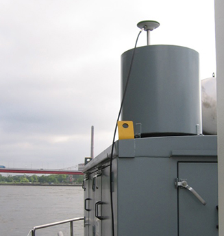
An antenna and a receiver were mounted on the surveying vessel to collect the GNSS data with an interval of 1 second during two days.
Experimental Work. Two kinematic trajectories were observed on the Rhine River in Duisburg, Germany, as a part of the project “HydrOs — Integrated Hydrographical Positioning System.” The project was launched in cooperation with Department M5 (Geodesy) of the German Federal Institute of Hydrology (BfG) and the Institute of Engineering Geodesy at the University of Stuttgart (IIGS) .
An antenna and a receiver were mounted on the surveying vessel (inset photo, opener) to collect the GNSS data with an interval of 1 second during two days. The virtual SAPOS (SAtellitenPOSitionierungsdienst der deutschen Landesvermessung) reference station was considered as a reference station, provided from the SAPOS-NRW team. SAPOS is a continuously operating reference station (CORS) GNSS service collecting data throughout Germany.
Results and Discussions
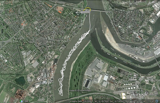
The layout of the first trajectory, which was observed for more than three hours, is presented in Figure 3. The measurements started from the inner harbour in Duisburg. The left figure shows the overview layout, and the right figure illustrates a zoom-in of the trajectory below two bridges. The white line refers to the kinematic PPP trajectory; the cross-hatched white line shows interpolated points between two solved points from the PPP solution. Because of loss of GNSS signals from the bridges, the yellow line indicates the actual vessel trajectory below bridges.
Figure 3. Layout of the first trajectory [DOY: 2014/126], zoom-in on bottom. (Photos: Google Earth)As mentioned before, the double-difference solution of the Bernese software is considered as the reference solution for the PPP solution. The PPP residuals for phase and code observations (not using double-difference solution) are presented in Figure 4. Here the residual values in phase and code have a gap because of the loss of GNSS signals, which starts from epoch 438 to 486 [GPS week second = 199845: 200115]. Additionally, there are some cycle slips from epoch 883 to 892 [GPS week second = 202105: 202150].
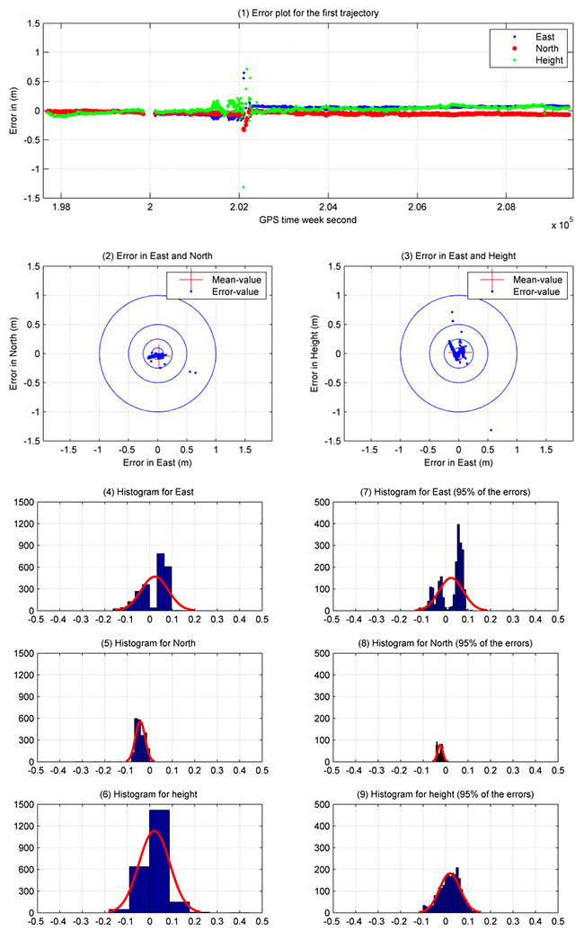
Figure 4. Satellite residuals for the first trajectory [DOY: 2014/126].To assess the accuracy of the PPP solution for this hydrographic trajectory, Figure 5 illustrates the analysis results for this trajectory between the double-difference and PPP solutions. The X-axis refers to the number of observations (one epoch/5 seconds), and the Y-axis indicates the error value in meters. Figure 5.1 shows the error plot (m) in east, north and height. As shown previously, the error values have a gap in the solution because of the loss of lock below the bridges. Moreover, there are some cycle slips later on, which decrease the estimated kinematic PPP accuracy.
Figures 5.2 and 5.3 provide the error plot for the east and north and east and height directions. The blue points refer to the errors, and the red cross refers to the mean value. Table 1 summarizes the PPP results.
Table 1. Statistical results of the first trajectory [DOY: 126/2014].Five percent of the PPP errors are eliminated to get outlier-free results. The SD (95%) of the kinematic PPP solution is obviously improved to reach 5.0 cm, 1.20 and 5.0 cm in east, north and height directions, respectively.
To distinguish between the standard deviation and the standard deviation based on 95 percent of the data, Figure 5 shows additionally the histogram of SD in Figures 5.4, 5.5 and 5.6 for east, north and height respectively. Figures 5.7, 5.8 and 5.9 provide the error with 95 percent of the results. Absolutely, the error range is improved by eliminating 5 percent of the data including outliers.
Figure 5. Analysis results for the first trajectory. Standard deviations shown in plots on the left, with outliers excluded, right.
Second Data Set. The second trajectory on the Rhine River was observed [DOY: 127] for more than 5 hours (see Figure 6). Sixteen satellites were observed during the measurement time.
Figure 6. Layout of the second trajectory [DOY: 127/2014]. (Photo: Google Earth)In Figure 7, the phase and code residuals are plotted. Some outliers are reported in this graph, which refers to cycle slips during the observations.
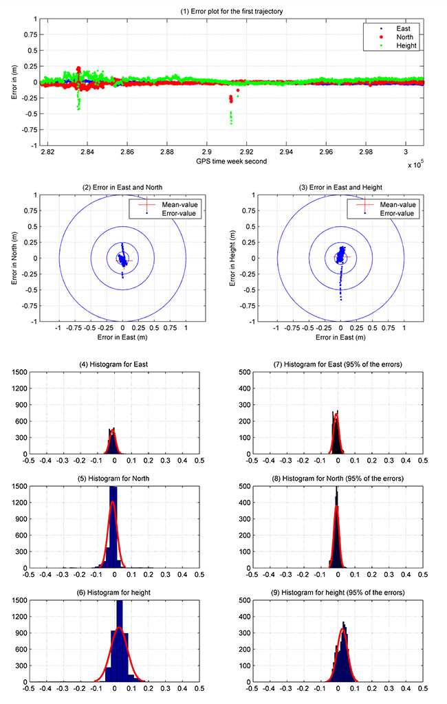
Figure 7. Satellite residuals for the second trajectory [DOY: 127/2014].Figure 8 illustrates the PPP results for this kinematic trajectory. Figure 8.1 shows the PPP error values in the east, north and height directions with respect to the double-difference solution from Bernese software.
Figure 8. Kinematic PPP solution for the second trajectory. Standard deviations shown in plots on the left, with outliers excluded, right.
The first 40 minutes of that trajectory were realized in a quasi-static observation technique (nonmoving vessel) from GPS week second 281660: 284060. The result obtained from this solution is more accurate due to the high number of satellites, and the trajectory did not include the bridges area. Figure 8.2 and 8.3 show errors in east and north, and east and height.
As shown in Table 2, the maximum and minimum values for the error range, which are presented in detail in Figure 8.4, 8.5 and 8.6, are reported in the east, north and height directions. These figures show the frequency histogram for the PPP errors. The RMS error from the solution is 2.10 cm and 2.90 cm in east and north respectively, with an RMS error of 5.60 cm in height. The standard deviation is definitely improved after eliminating 5 percent of the PPP errors as outliers. The standard deviation for 95 percent of the results shows 1.5 cm in east and north and 3 cm in height. The error histograms for 95 percent of the data are provided in Figures 8.7, 8.8 and 8.9.
Table 2. Statistical results of the second trajectory [DOY: 127/2014].The second trajectory clearly provides a higher accuracy than the first. Its data has a higher number of satellites and lower outliers than the first. Figure 8 shows the histogram of the second trajectory is similar to the Gaussian distribution curve.
Acknowledgments
The authors would like to thank Annette Scheider for receiving the GNSS measurements through the HydrOs project, our BfG partners Harry Wirth and Marc Breitenfeld, and Bernhard Galitzki form SAPOS-NRW for providing us with the reference stations.
This article is based on a peer-reviewed paper presented at the FIG Working Week, May 2015, in Sofia, Bulgaria.
Manufacturers
A Leica 1203+ antenna and GX1230+ GNSS receiver collected the data shown here.
Ashraf Abdallah is an assistant lecturer in engineering, Aswan University, Egypt, and a Ph. D. student at the Institute of Engineering Geodesy (IIGS), Stuttgart University, Germany. He received a master’s degree from Aswan University in applications of single-frequency GNSS.
Volker Schwieger is a full professor at the University of Stuttgart and director of the IIGS. He received a Ph.D. from the University of Hannover, focusing on GPS for monitoring applications.
Applanix has introduced an expanded portfolio of marine georeferencing and motion compensation solutions. Taking advantage of Applanix proprietary technology, the new line-up of marine products offers high-performance solutions to a broader cross-section of the hydrographic survey industry.
All Applanix Marine products benefit from the optimal integration of GNSS and inertial observables, with access to Trimble GNSS technology for performance advantages.
The Applanix POS MV Surfmaster.
The announcement was made at Ocean Business 2015, an exhibition of more than 300 of the world’s leading manufacturers and service providers in the industry.
“Advances in Applanix inertial technology enable us to offer the high performance levels we are known for at even more attractive price points. By introducing this new product portfolio, we are able to deliver solutions suited to all types of bathymetric mapping,” said Peter Stewart, director of Marine Products. “This revised product lineup demonstrates Applanix’ continued commitment to provide customers with options that best fit their budget and requirements.”
At the entry level of the expanded product portfolio, Applanix introduced the new POS MV SurfMaster. Incorporating Applanix’s proprietary SmartCal inertial calibration techniques, POS MV SurfMaster delivers robust georeferencing for small platforms, both manned and unmanned. SurfMaster is fully supported by Applanix’ post-processing software POSPac MMS, and can deliver roll and pitch accuracy to 0.03 degrees, regardless of latitude or rate of vessel motion.
Applanix’ new marine product lineup also includes POS MV WaveMaster II and POS MV OceanMaster. Using newly developed inertial technology, POS MV WaveMaster II delivers performance equal to the well-established and proven WaveMaster E, but at a new lower price point. POS MV OceanMaster replaces the POS MV 320 E as the georeferencing and motion compensation solution of choice for the hydrographic professional, integrating next generation inertial sensors, which enable performance and pricing previously unavailable with this class of technology. POS MV OceanMaster provides reliable and robust surveying in even the most demanding sea conditions. POS MV Elite remains the ultimate option for users seeking the highest level of performance available to the industry.
The new POS MV SurfMaster, POS MV WaveMaster II and the POS MV OceanMaster are available now worldwide through the Applanix sales channel.


![Figure 3. Layout of the first trajectory [DOY: 2014/126], zoom-in on bottom. (Photo: Google Earth)](https://stage.globalpositioningnews.com/wp-content/uploads/2015/12/Figure-4-W.jpg)
![Figure 4. Satellite residuals for the first trajectory [DOY: 2014/126].](https://stage.globalpositioningnews.com/wp-content/uploads/2015/12/Figure-5-W.jpg)
![Table 1. Statistical results of the first trajectory [DOY: 126/2014].](https://stage.globalpositioningnews.com/wp-content/uploads/2015/12/Table1.jpg)
![Figure 6. Layout of the second trajectory [DOY: 127/2014]. (Photo: Google Earth)](https://stage.globalpositioningnews.com/wp-content/uploads/2015/12/Figure-7-W.jpg)
![Figure 7. Satellite residuals for the second trajectory [DOY: 127/2014].](https://stage.globalpositioningnews.com/wp-content/uploads/2015/12/Figure-8-W1.jpg)
![Table 2. Statistical results of the second trajectory [DOY: 127/2014].](https://stage.globalpositioningnews.com/wp-content/uploads/2015/12/Table2.jpg)