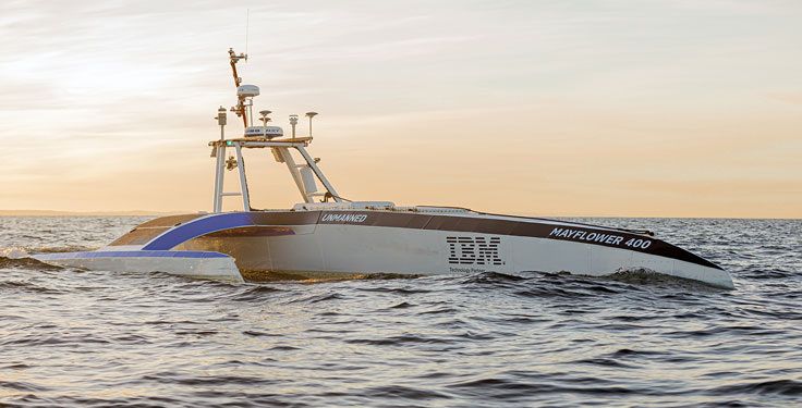
IBM, a global technology provider, has released its latest geospatial artificial intelligence (AI) initiative to address climate change. These efforts involve collaborations across various regions and uses advanced AI models designed for geospatial applications.
Central to these initiatives is IBM’s geospatial foundation model, developed jointly with NASA. These models aim to generate environmental insights and solutions related to climate change. Unlike traditional AI models, these use a vast amount of climate-relevant data to accelerate the analysis of various environmental aspects that are affected by climate change.
“AI foundation models utilizing geospatial data can be a game-changer, allowing us to better understand and address climate-related events with unprecedented speed and efficiency,” said Alessandro Curioni, IBM fellow and vice president of Accelerated Discovery.
Analyzing urban heat islands in UAE
IBM and the Mohamed Bin Zayed University of Artificial Intelligence (MBZUAI) have partnered to map urban heat islands in Abu Dhabi using a fine-tuned version of IBM’s geospatial foundation model. The goal of the project is to understand the impact of local landscapes on temperature anomalies, the company said. The initial results show a decrease in heat island effects, which can provide valuable insights for future urban design strategies.
Reforestation and water sustainability in Kenya
In partnership with Kenya’s Special Envoy for Climate Change, Ali Mohamed, IBM is supporting the National Tree Growing and Restoration Campaign. The initiative aims to plant 15 billion trees by 2032, particularly in critical water tower areas affected by deforestation. IBM’s geospatial model powers a digital platform to track tree planting activities, aiding local efforts in restoring forests and measuring carbon sequestration impact.
Elevating climate resiliency in the UK
In collaboration with the Science and Technology Facilities Council (STFC) and Royal HaskoningDHV, IBM is developing AI-driven tools for climate risk assessment in the UK. These tools will focus on assessing weather impacts on aviation operations, the company said. Additionally, the TreesAI research project aims to map areas suitable for tree planting to mitigate surface water flooding and offer urban developers a digital planning platform.
IBM extends collaboration with NASA for weather forecasting
IBM and NASA have partnered to develop an AI foundation model dedicated to weather and climate applications. The collaboration aims to enhance the accuracy and speed of weather forecasting, predict wildfire conditions and understand meteorological phenomena. IBM researchers will work closely with NASA to train and validate this model, IBM said.
The Mayflower Autonomous Ship (MAS) is set to re-embark on its three-week trans-Atlantic journey in April 2022 equipped with two of Silicon Sensing’s AMU30 inertial measurement units (IMUs). These devices send highly precise motion data to the new ‘AI captain’ that guides the vessel. They also assist in measuring sea surface height as part of detailed scientific analysis of ocean topography.
AMU30 is a micro electro-mechanical system (MEMS) unit with excellent inertial performance, including very good bias stability and low noise characteristics, plus an embedded Kalman Filter-based AHRS (attitude and heading reference system) algorithm. It delivers precise 3-axis outputs of angular rate and acceleration, plus roll, pitch and heading angles, altitude and pressure, and temperature, at 200 Hz — all critical to precise maritime navigation.
“The two AMU30 are used to make real-time, precision measurements of the movement of the Mayflower Autonomous Ship in 6 degrees of freedom (DOF) so that the AI Captain may make minute manoeuvring adjustments to optimise vessel performance in a complex wavefield, while also providing redundant general navigation capability at sea,” said Brett Phaneuf, co-director of the project. “Furthermore, when coupled with optical and RTK (real time kinematics) GPS data, the AMU30 assists the ship in making highly accurate measurements of sea surface height, which are important for studying ocean tides, circulation and the amount of heat the ocean holds.”
The MAS journey across the Atlantic will celebrate the voyage of the original Mayflower some 400 years ago. It is just one element of an extensive scientific data gathering and research programme the vessel will complete in the coming years. The ship is guided by its new AI Captain, built using IBM cloud, artificial intelligence (AI) and edge computing technologies, and uses a hybrid engine that draws on solar power. Working with scientists and other autonomous vessels it provides a flexible platform for deepening understanding of issues such as climate change, ocean plastic pollution and marine mammal conservation. In parallel, the development of marine autonomous systems such as this will transform ocean-related industries such as shipping, oil & gas, telecommunications, security & defence, fishing & aquaculture.
“Seen & Heard” is a monthly feature of GPS World magazine, traveling the world to capture interesting and unusual news stories involving the GNSS/PNT industry.
Photo: IBM
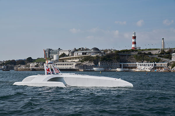
Sailing new school
An autonomous ship designed to recreate the Mayflower’s historic journey across the Atlantic 400 years ago returned to the UK after developing a mechanical problem. IBM’s Mayflower Autonomous Ship (MAS) set sail on June 15 on its 3,500-mile journey from Plymouth in the UK to Massachusetts in the United States. The voyage is expected to take about three weeks, and includes collections of data on marine life and sampling for plastic waste. The 50-foot long, solar-powered trimaran is capable of speeds of up to 10 knots (18 km/h) and is being navigated by on-board artificial intelligence (AI) with information from six cameras and 50 sensors. Project leaders say the AI worked perfectly. The ship navigates with precision GNSS, inertial measurement units, radar, weather station, SATCOM and the automatic identification system.
Photo: Lt.j.g. Alexander Fairbanks/U.S. Navy
Sailing old school
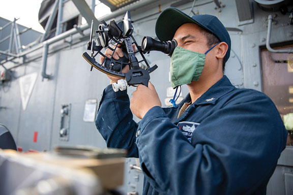
U.S. Navy sailors aboard mine-countermeasures ship USS Patriot used celestial navigation to navigate an 1,100-mile voyage back to port on the western coast of Japan in July 2020. The voyage allowed the crew to improve their mariner skills as they used sextants to find their latitude and longitude and compasses to determine their heading. The exercise wasn’t entirely old school. The sailors entered the celestial measurements into a computer to pinpoint their position using the System to Estimate Latitude and Longitude Astronomically (STELLA). The combination of repeatedly inputting sextant measurements, the course and speed of the ship, and time into STELLA, provided an accurate fix of the ship’s position. For backup, Combat Information Center (CIC) watch standers followed the ship’s course with GPS. Training in celestial navigation returned to the Navy as a core competency in 2016, 17 years after the U.S. Naval Academy stopped requiring midshipmen to learn the technique.
Photo: Lt.j.g. Alexander Fairbanks/U.S. Navy
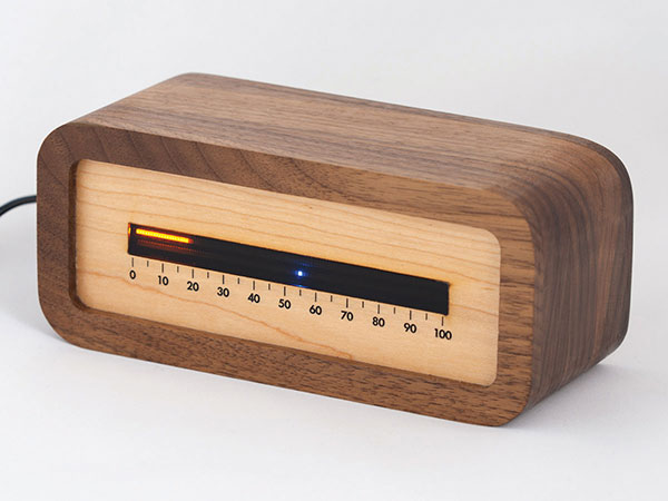
Linear clock shows sunrise, sunset
A creative technologist spent his COVID-19 downtime creating a device that uses a GNSS receiver to compute time relative to sunrise and sunset. “Since it derives time from the satellite signal, it never needs to be set, or ever adjusted for daylight saving time,” explains creator James Wilson on his webpage. The device uses satellite navigation and astronomy to show time as a progress bar measuring the percentage of the day elapsed since sunrise. A second indicator marks the time to sunset in blue.
Tracking Iran’s nuclear site
A team with Stanford University’s Center for International Security and Cooperation (CISAC) is keeping tabs on activity at Iran’s Natanz nuclear facility using BlackSky’s geospatial imagery and burst collection technology. BlackSky’s satellites provide intraday revisit capabilities, allowing CISAC’s research team to receive multiple images a day, throughout the day, rather than just one image collected at roughly the same time each day. The satellites also can capture a sequence of 20 images within minutes (burst collection) and splice them together to generate a moving sequence of activity. With BlackSky’s assistance, the research team was able to witness trucks emerging from the facility’s underground tunnels.
“Seen & Heard” is a monthly feature of GPS World magazine, traveling the world to capture interesting and unusual news stories involving the GNSS/PNT industry.
The Mayflower autonomous ship. (Photo: Tom Barnes for IBM)
No pilgrims needed aboard
The autonomous Mayflower trimaran launched Sept. 16 from Plymouth, England, on a mission to traverse oceans and gather vital environmental data, guided by Veripos GNSS and inertial measurement units from iXBlue and Silicon Sensing. Ocean research non-profit ProMare joined with IBM on the Mayflower Autonomous Ship — an artificial intelligence and solar-powered marine research vessel, two years in the making. Designed to provide a safe, flexible and cost-effective way of gathering data about the ocean, the Mayflower works in tandem with scientists and other autonomous vessels to help understand critical issues such as global warming, micro-plastic pollution and marine mammal conservation.
Photo: nycshooter/E+/Getty Images
A Guardian on the Bus
A school bus app aims to help monitor students’ exposure to others. App developer CalAmp’s Bus Guardian uses the same technology from its Here Comes the Bus app with an added layer of contact tracing. With Bus Guardian, parents can opt-in and invite their student to check on and off the bus. It uses telematics to convert a school bus into a contact tracing solution. Schools can deliver instant and actionable reports of ridership based on contact tracing — important if a student or driver becomes ill.
The Erta Ale volcano. (Photo: guenterguni/E+/Getty Image)
Rift splits Africa in two…eventually
GPS data is refining predictions of when Africa will split into two continents. In 5 to 10 million years , the Gulf of Aden and the Red Sea will flood the Afar region and the East African Rift Valley, creating a new ocean and continent. GPS data is precisely measuring ground movement as three tectonic plates peel away from each other at a triple junction, said Ken Macdonald, professor emeritus, University of California, Santa Barbara. “With GPS measurements, you can measure rates of movement down to a few millimeters per year,” Macdonald said. “As we get more and more measurements from GPS, we can get a much greater sense of what’s going on.”
Image: Rosie Bisset
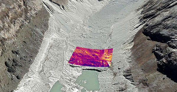
Dangerous Retreat
In a first for mapping glacier retreat in the Peruvian Andes, the CASCADA UK + Peru glacier project used a drone fitted with a FLIR Vue Pro R 640 thermal-imaging camera for insight. A thicker layer acts as insulation. Researcher Rosie Bisset, Edinburgh University, is building a mosaic of the images to better understand how surface cover is affecting the melt rate. The glaciers have shrunk by about 30% in the past few decades, and pose a serious threat to the water supply of in the Ancash region.
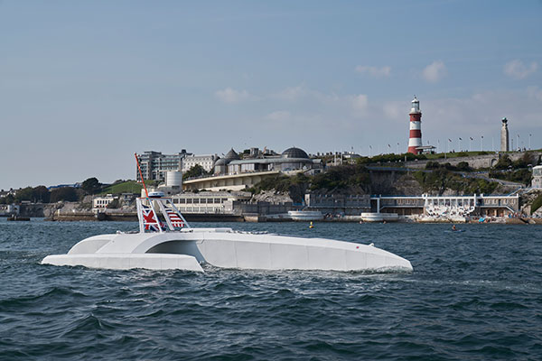
An autonomous ship launched Sept. 16 on a mission to traverse oceans and gather vital environmental data, guided by GNSS and inertial measurement units (IMUs).
Ocean research non-profit ProMare joined with IBM on the Mayflower Autonomous Ship (MAS) — an artificial intelligence (AI) and solar-powered marine research vessel. Following two years of design, construction and training of its AI models, the fully-autonomous trimaran was launched from Plymouth, England.
The ship is guided by both GNSS and IMU technology. It uses two Hexagon | Veripos LD8 receivers, each with two V560 marine antennas. The onboard IMUs include an iXBlue Octans and two Silicon Sensing AMU30s.
Designed to provide a safe, flexible and cost-effective way of gathering data about the ocean, the new-generation Mayflower promises to transform oceanography by working in tandem with scientists and other autonomous vessels to help understand critical issues such as global warming, micro-plastic pollution and marine mammal conservation.
ProMare is coordinating the scientific studie,s working with IBM Research and leading scientific organizations.
MAS features an AI captain built by ProMare and IBM developers that gives MAS the ability to sense, think and make decisions at sea with no human captain or onboard crew. The new class of marine AI is underpinned by IBM’s latest advanced edge computing systems, automation software, computer vision technology and Red Hat Open Source software.
“Able to scan the horizon for possible hazards, make informed decisions and change its course based on a fusion of live data, the Mayflower Autonomous Ship has more in common with a modern bank than its 17th century namesake,” said Andy Stanford-Clark, Chief Technology Officer, IBM UK & Ireland. “With its ability to keep running in the face of the most challenging conditions, this small ship is a microcosm for every aspiring 21st century business.”
Artie — short for Artemis and artificial Intelligence — is a stowaway hitching a ride on the Mayflower who answers questions about the ship, the ocean or himself on mas400.com. (Photo: IBM)
Interactive web portal follows voyage
To enable followers around the world to stay updated with MAS as it undertakes its various missions, IBM and ProMare have also launched an interactive web portal. Built by IBM iX (the business design arm of IBM Services), the MAS400 portal is designed to provide real-time updates about the ship’s location, environmental conditions and data from its various research projects.
Live weather data is streamed from IBM’s The Weather Company, as MAS receives forecast data and insight from the new IBM Weather Operations Center.
‘Octopus’ aboard answers questions
The portal even features a seven-armed, stowaway octopus chatbot called Artie, who claims to be hitching a ride on the ship. (With seven arms, he’s technically a septopus.) Powered by IBM Watson Assistant technology and created in partnership with European startup Chatbotbay, Artie has been trained to provide information about MAS and its adventures in a lively, and accessible format.
“MAS400.com is one of the most advanced ocean mission web portals ever built,” says Fredrik Soreide, Scientific Director of the Mayflower Autonomous Ship project and Board Member of ProMare. “Protecting the ocean depends on our ability to engage the public in important matters affecting its health. This MAS400 portal is designed to do exactly that and tell people where the ship is, what speed it’s travelling at, what conditions it’s operating in and what science we are conducting. Users can even help Artie the Octopus fish out surgical masks, cigarette butts and other increasingly common forms of ocean litter from a virtual ocean of facts and data.”
MAS will spend the next six months in sea trials and undertake various research missions and voyages before attempting to cross the Atlantic in Spring 2021. MAS’s transatlantic voyage will be based on a similar route and pioneering spirit to the 1620 Mayflower which made the same crossing 400 years ago.
Regular readers of GPS World are aware of many of the rapidly developing technologies and navigational systems being created around the world, but often the everyday surveyor shows up late to the party.
While smartphones get the most mainstream media coverage, other navigational devices and measurement systems are adapting to evolving technical breakthroughs and new methods of transmitting a variety of data wirelessly.
This month’s article looks at the increase in satellite navigation networks along with the rollout of 5G cellular technology. Both advancements will benefit the surveying community; to start, I’ll explain what this means for accuracy and precision of survey measurements as well as productivity.
Everybody gets a constellation! (with apologies to Oprah)
I’ve been known to wax poetic in this column about my admiration of GNSS technology, and I continue to marvel at the “accidental” civilian use of a military tool. This method of measurement and navigation continues to expand, refine and transcend everyday life, and surveying is no exception.
The satellite constellation is the mainstay of this navigational system. The United States began the charge several decades ago, but other nations are quickly catching up. Let’s look at the current constellations and their status.
Operational Systems
GPS (United States)
GLONASS (Russia)
Galileo (European Union)
Beidou (China)
QZSS (Japan)
IRNSS (India)
Chart: GPS World
There are now more satellites. What’s the big deal?
The addition of these constellations provides large gains for the surveying community in several different ways.
First, the additional satellites mean more signals to help with the mathematical equations necessary for positional determination. While traditional surveying in the general public’s eye is associated with measurements on the ground, our expansion of services into the air and water relies heavily on GNSS determined positions.
No matter what type of remote sensing equipment is being used (lidar, photogrammetric, sonar, etc.), positional determination for most of those sensors are derived from GNSS-based receivers. Add to these measuring methods the ability to perform operations via remote-controlled or autonomous vehicles in both air and water, and the availability of additional satellite signals enhances the reliability of GNSS-derived data and attributes.
Second, by having more satellite signals to utilize, GNSS receiver manufacturers can improve the software for processing the positional information with greater certainty of accuracy.
Before the introduction of additional constellations and receivers with expanded signal reception, GNSS users relied on less sophisticated software to identify potential “bad” signals that would lead to incorrect positions. While the software generally provided reasonable reliability, it was not foolproof and occasionally would allow bad data to be accepted.
Like most everything tech-related, however, the GNSS industry has benefited from increased computing power to go along with the additional satellite constellations. The latest GNSS receivers can accept well over 500+ signals from a variety of sources (including land-based transmitters). The software used to reduce all that data has increased in complexity along with number of those data sets.
Complex computations that were once limited to mini-computers or even mainframes are now being completed on handheld data collectors in minuscule timeframes compared to their predecessors.
The software has also been enhanced to analyze the data in real-time, compute the likely position of the receiver and notify the user of potential incorrect or “spoofed” data from any number of satellites.
Considering that many of the remote-sensing sources now collect millions of points based upon one GNSS-based position, the need for increased positional verification has become a critical issue. By having many more constellations to provide signals for positional data, the percentage of establishing a correct location for each data point has increase significantly.
The improved computing power and verification ability of today’s GNSS software is helping to eliminate errors in positional accuracy and instill more confidence in the surveyor’s data collection activities.
Add to these additional constellations the planned installation of more land-based signal providers to augment or provide a backup plan for satellite systems, and it’s clear that the future is quite bright for GNSS-based receivers and data collection for everyone — especially the surveying community.
The history of wireless communication
While surveyors marvel at the advancements of GNSS-based measurement, it pales in comparison to the rapid growth of modern technology with cellular devices. Notice I didn’t write cellular phones, as the technology has quickly established itself as much more than voice communication. Before we lay out the future of cellular data networks, let’s take a step back and see how this type of communication has revolutionized GNSS-derived data collection for surveyors and others.
Two-way, CB and shortwave ham radio
1947 two-way radio advertisement. (Image: Motorola)
The technology behind wireless communication goes back several decades, but didn’t become a mainstream system until the late 1970s and early 1980s. Motorola is known as the early force behind the two-way radio system, but the base and remote transmitters were not cost effective for small businesses. This type of system was also limited to single-purpose radios with individual crystals wired within that only allowed specific frequencies to be transmitted.
Another type of communication used by some was the citizens band radio, affectionately referred to as CB radio. This radio was limited to 40 channels and didn’t allow for private transmission between two parties. During the 1970s, the use of the CB radio was not limited to long-haul truck drivers — many people used the medium for basic communication.
Vintage CB radio ad from Radio Shack. (radioshackcatalogs.com)
Telephone service during these times was still costly and long-distance calls were not cost-effective, so many found the CB radio as an alternative to conventional phone service. Looking back now, it is not a stretch to classify this type of broadcasting as a primitive social media precursor to today’s methods but limited to live chats and no visuals.
Another method of transmission was short-wave radio. This system was like two-way radios with an established base transmitter, but broadcast on public frequencies over greater distances than CB radios. One of the big drawbacks was the upfront costs, which were much more significant than the other radios. Even more expensive was outfitting a vehicle with a shortwave system, so cost was the biggest limiting factor for this mode of communication.
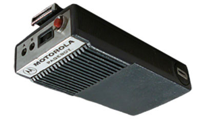
Pagers of all shapes and sizes
Motorola’s Pageboy pager. (Photo: Motorola)
The popularity of telephone-based pagers didn’t hit its zenith until the early 1990s, but the technology and actual use dates to the early 1960s. The first commercial pager was produced by Motorola in 1964 and called the Pageboy. There was no screen or display; the user was notified by a variety of tones preset for distinct situations or needs. As this technology advanced, variations in screens, message types and even two-way communication became possible.
By 1994, there were more than 60 million pagers in use, but a change was in the technological wind; cellular phones were marching toward the mainstream.
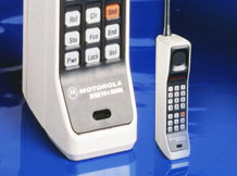
While the concept of wireless telephone communication existed in several laboratories around the world for years, the first big breakthrough was made by researcher Martin Cooper, who developed a prototype cellular device for Motorola in the early 1970s. He famously made the first public cellular phone call on April 3, 1973, to Joel Engel, head of research at Bell Labs, during a walk in New York City. Cooper and Engel were engaged in a rivalry to develop the first commercially available cellular phone with the Motorola DynaTAC prototype being the first to make a successful call.
However, the rush to get cellular phones to market took longer than anticipated. It wasn’t until the introduction of the Motorola DynaTAC 8000 in 1983 (available to the public in March 1984) that the reality of wireless phones came to life. The cost of wireless freedom came at a price: $3,500 for a brick-sized phone that took 10 hours to charge for 30 minutes of use. The cost of the service was also expensive due to the limited cellular infrastructure.
The next decade brought us expanded cellular coverage along with miniaturization of phone; each subsequent model provided more features and longer battery life. From the Nokia “candy bar” to the Motorola Razr, the cellphone era had engulfed the mainstream, but more changes were ahead for mobile communications.
The late 1990s saw the introduction of the cellphone as a computer modem, with limited email connectivity and primitive internet browsers built into the operating systems. But like many electronic technologies that came before, the cellphone would begin a radically different life in the mid-2000s.
Enter the smartphone to help us dummies
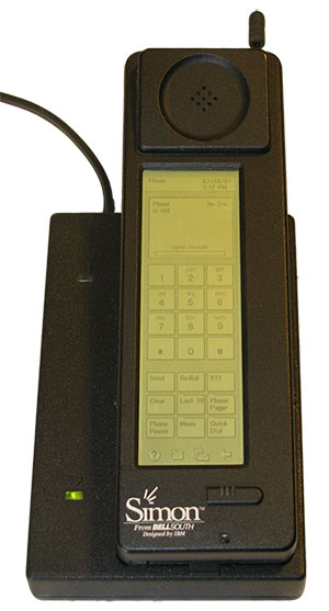
The IBM Simon Personal Communicator and charging base. (Photo: IBM/public domain)
Officially, the smartphone has been in existence since 1992 with the creation of the Simon Personal Communicator from IBM. At a cost of $1,100, with a monochrome screen that was 4 ½ x 1 ½ inches, the Simon allowed the user access to email and faxes (remember those?) along with the phone function — but users had to make it fast; the battery only lasted an hour. IBM sold 50,000 of these units before pulling the plug on the project, but it started the trend toward mobile telephones with a graphical interface and extended uses beyond the standard verbal communications.
Just like the Apple Newton was the failed precursor to the Palm Pilot, various tablets and eventually today’s smartphone platform, the Simon broke ground and established new directions for future communication.
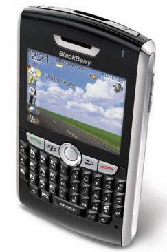
The early 2000s introduced us to the Blackberry personal digital assistant (PDA) and phones from Research in Motion (RIM), a small electronic communications company from Ontario, Canada. RIM started small with a two-way paging system that became popular in Europe and quickly morphed into cellular devices that worked on the DynaTAC network used by Motorola.
A recent model Blackberry PDA. (Photo: Blackberry)
By the mid 2000s, their devices became affectionately known as the “Crackberry” as users became addicted to the functions and capability of this communication tool. These devices were popular with business users as the security encryption was considered more effective than any of the other communication apparatuses of the day.
By 2009, Blackberry had reached the zenith of the mobile device market (second only to the conventional mobile-phone platform dominated by Nokia) but began a rapid decline due to proliferation of the next big thing — the touchscreen smartphone.
After Apple’s introduction of the iPhone in 2007, followed by a crowd of Android-powered phones in 2008 and beyond, Blackberry’s market share has been reduced to a small niche group.
And now, why this relates to the surveyor…
The rollout of Steve Job’s dream of combining Apple’s industry-defining iPod with mobile phone capability revolutionized not only the way we communicate — it has redefined our everyday environment. Many of the tasks we accomplish every day have been incorporated into a smartphone application, which brings us back to the reason this article is directed at surveyors: the device that hangs on your belt or rests in your pocket is revolutionizing the way today’s surveyors work.
Not that long ago, the only navigational devices available were large, expensive and difficult to use. Now, nearly everyone owns a device with GNSS capability. When we combine the ever-expanding number of devices along with the increased coverage of GNSS satellite constellations, the ability to georeference any piece of data to greater precision and accuracy is improving.
Surveyors need to embrace this technology within their smartphones to increase their efficiencies. At the same time, we need to help educate the public on why having better smartphone location capability doesn’t mean the masses can perform their own boundary analyses. For more information on this subject, see the GPS World July 2017 article.
Surveyors should embrace the smartphone as an important tool; the introduction of new survey-grade GNSS receivers that use an app for the user interface will soon become commonplace.
Several GNSS manufacturers have introduced receivers that exclusively use a smartphone and app for data collection, eliminating the need for a dedicated (and usually proprietary) data collector for obtaining centimeter-level location data. I’m not advocating that the surveying community throw their existing systems in the trash in favor of these newer receivers, but the data-collection techniques utilized by smartphones can increase efficiency and reduce equipment costs.
The Mi 8 smartphone offers dual-frequency capability. (Image: Xiaomi)
Another reason to pay attention to the smartphone as a location tool will be the expanded use of dual-frequency chipsets to provide even higher accuracies. One of the fastest growing phone makers worldwide is Xiaomi, based in Beijing, China, which introduced the Mi 8 phone with a dual-frequency GNSS chip. This chip frequency reception (E1/L1+E5/L5) is targeted to embrace the Galileo and GPS constellations for increased accuracies (within a decimeter), well beyond the current norm for smartphones (typically 1-3 meters, plus or minus). For the surveyor, having this capability in their pocket can greatly increase efficiencies, especially when used during reconnaissance efforts. I believe many more phone manufacturers will begin to incorporate dual-frequency chips in their future models to increase location accuracies for users and take advantage of upcoming network enhancements.
Speaking of network enhancements, let’s talk 5G as a gamechanger.
The latest buzz in the general population’s lexicon is 5G and how it will push high-speed internet to all corners of the world. While this is a possibility, it means much more to the surveyor than meets the eye. Yes, there will be increased cellular coverage in places that previously lacked it, or only had limited access, but 5G means much more than that.
Image: NTT DOCOMO Inc. 5G white paper.
Let’s refresh our view of what cellphone coverage currently means to the surveyor. The use of cellular-based RTK receivers has been greatly expanded due to the increased coverage of 4G LTE signals throughout the world, but it’s still scarce is some parts. This is mostly due to the transmission of cellular signals being required from towers and higher placed antennas with powerful transmitters. These transmitters are costly and typically owned and installed by the larger telecom companies, so placement is traditionally in more populated areas.
Enter 5G — while it will provide enhancements for all users, it will be revolutionary for the surveyor. 4G cell coverage was a broad and powerful signal from large transmitters; 5G cellular service consists of smaller cell signals placed in a tight grid of broadcast positions. These transmitters will be more cost effective for many telecom providers and will increase data reception for many users. For surveyors, the additional coverage of 5G will make possible the use of cellular-based RTK GNSS data collection in places not previously possible.
Besides the extended coverage of 5G, the 10-fold speed of the new data transmission protocol compared old 4G LTE creates many possibilities for information collection growth. Soon it will be possible for a field personnel and the office staff to be linked in real time during the data collection process.
From boundary-point recovery to complex topographic surveys, a field crew’s work can be supervised and reviewed while being completed, allowing for instantaneous analysis and guidance from senior staff. This process will allow for more oversight, quality control and mentoring of field staff than is possible for today’s remote crew operations. The new technology will also allow for reduced timeframes when crews are required to provide field data for tight deadline requests and gives us a method of instant feedback on the amount and quality of the data collection.
Some may see this improvement in connectivity as an avenue for office staff to be intrusive on their field activities, but I see this as an opportunity for improved quality control and increased team interaction. More connected teams can lead to improved efficiencies and overall increases in productivity, profitability and morale among team members.
From outside to inside
Another breakthrough created by 5G will be the enhancement of indoor georeferenced location services. By having several transmitters placed throughout a facility, trilateration will be possible to provide more accurate location information for places not typically available to surveyors.
Depending on the accuracy needed and placement of the cell providers, it will possible for surveyors to use devices designed for remote sensing (laser scanners, lidar, SLAM, etc.) and collect georeferenced data with greater accuracy in relation to a known coordinate system. This by-product will also aid rescue and medical providers during emergencies to help pinpoint individuals through their cellphone connection more accurately than before.
5G is more than just bringing YouTube videos to your phone faster; it will improve the data collection process of all shapes and sizes. Surveyors will not get left out, but we will need to be ready to take advantage when it comes online. For more on the 5G revolution, see the GPS World February 2018 article on this topic.
As surveyors, just when we think that technology can’t take us further, we blink and change happens. Moore’s law stated (depending on which revision) that technology would double the number of transistors every one to two years. While some may say that technology is making Moore’s law obsolete, I believe the creativity being used to invent new processes based upon the technology is holding strong.
I, for one, look forward to many more enhancements to follow in the coming years. Surveyors be ready; the future is here.
IBM’s inventors have been granted a patent for transferring packages between drones during flight.
The invention, described in U.S. Patent No. 9,561,852: In flight transfer of packages between aerial drones, helps to extend the range of drones that are delivering packages from a warehouse to a customer’s home.
IBM inventors developed this patented system using their supply chain expertise to enable precise delivery services to customers using drones.
Drones are starting to be used to transport packages to customer locations, but there are still numerous challenges to this delivery method such as limited flight range, theft of unattended packages once delivered, and a lack of delivery network optimization.
The invention can help to mitigate these challenges by providing in-flight drone-to-drone package transfers to extend package delivery range.
For example, a customer expecting a package could dispatch a personal drone to receive and securely deliver the package to the customer’s home. Drone delivery network optimization could be provided to autonomous drones via the communications link described in the patent.
“Drones have the potential to change the way businesses operate and by leveraging machine learning, drones could change ecommerce,” said Sarbajit Rakshit, IBM master inventor and co-inventor on the patent. “Our inventor team is focused on improving how the most valuable cargo is delivered globally. This could create opportunities such as managing drones to deliver postal packages and medicine in developing countries via the most direct route.”
IBM inventors have patented other inventions related to drones and drone-enabling technologies. However, this is just one aspect of IBM’s Supply Chain and Logistics expertise. IBM manages supply chains for clients on a worldwide basis using IBM Watson Supply Chain. Learn more about IBM patents here.
Pitney Bowes, Inc., and IBM have announced a collaboration on IBM’s codename “BlueMix” platform-as-a-service to develop new hybrid cloud location services that help businesses unearth deeper connections between their customers, their geography, and their networks to deliver more personalized services and contextually relevant experiences.
IBM’s BlueMix is a new development environment that helps clients and developers speed the adoption of hybrid clouds. The initiative combines the strength of IBM software, third-party and open technologies. BlueMix provides DevOps in the cloud — an open, integrated development experience that scales to any level. Pitney Bowes is among the first third-party solutions now available to developers and companies on the new IBM BlueMix Platform-as-a-Service (PaaS).
More than 1.2 billion people around the world today use Pitney Bowes location intelligence solutions when they check in or use location-sharing features on major social media platforms. Pitney Bowes’ location intelligence suite of products offers comprehensive capabilities to provide businesses with the ability to visualize spatial data and understand relationships between specific locations. Using advanced, hyper-accurate location data, insurers can improve underwriting decisions, telecommunications providers can better analyze network coverage, and retailers can deliver more targeted promotions to consumers based on when and where they are most likely to buy.
For Pitney Bowes, the partnership provides the opportunity to expose key solutions, such as location-based services, e-commerce fulfillment, Internet postage, and parcel management, through IBM’s API Management to an extended ecosystem of innovators and developers. It also speeds the availability of new services from Pitney Bowes to vast new markets globally.
“Together, IBM and Pitney Bowes are developing a powerful lineup of cloud services around mobile application development and location intelligence,” said Steve Robinson, General Manager, IBM Cloud Platform Services. “This open-platform collaboration will inspire development that accelerates innovation and fosters growth.”
“Companies need tools and expertise to manage and integrate APIs, leverage location intelligence and customer data, and then seamlessly extend their services to reach their customers via the cloud and mobile devices,” said Roger Pilc, chief innovation officer for Pitney Bowes. “We look forward to delivering Pitney Bowes digital commerce solutions on IBM’s BlueMix.”
From CES to the Detroit Auto Show, it has been a big month for in-car connectivity that enables vehicle diagnostics, streaming entertainment, telematics and navigation. Ford, GM, Google and Audi unveiled new connected vehicle platforms and features, and AT&T stole the carrier limelight with LTE Connected Services.
Plus, two industry giants announced that they are working to enable vehicles to continuously record road position at accuracies of eight inches or less. Shoppers are becoming more open to sharing their personal location with retailers. And the U.S. GAO issued a report on location privacy related to vehicle technology and applications. It has been a busy month.
The first mass-marketed connected vehicle system was Ford Sync, which now boasts one million users and seems poised to grow rapidly with the release of an updated version. The Mustang will be the first of the company’s models with the new Ford Sync, which lets drivers use voice to activate iPhone and Android apps. New voice activated apps include Parkmobile, a parking space finder, and the Domino app, which lets me command my car to order a pizza, just the way I like it. GM announced its first LTE-enabled vehicles for about 10 of its models. Fast connectivity in vehicles will transform in-car experiences and hopefully not kill us.
Carrier Ringmaster. AT&T wrangled itself into the center ring of car connectivity announcements. The carrier has won a multi-year exclusive agreement to enable Telsa with high speed connectivity. Despite Audi’s collaborative relationship with T-Mobile, AT&T was able to steal some work away from T-Mobile by getting a deal to supply connectivity for some Audi models. AT&T has also teamed up with Ericsson, Amdocs, Jasper Wireless and others to create AT&T Drive, a mobile platform for developing LTE connected vehicle services.
Pathway to a Jetson Car. Two industry biggies, Continental and Here, are working together to create an end-to-end connected high-precision mapping and vehicle system offering for OEMs. The system will serve as the basis of highly automated driving functionality with the first objective of continuously determining road position to within three to eight inches. That’s quite a task. The maps will include road information that will feed vehicles with information to allow them to react to changing road conditions or speed limit changes, automatically. Continental was the first automotive supplier to be granted a test license for automated driving on public roads in Nevada.
See Me Now. The percentage of consumers willing to share their current location via GPS with retailers nearly doubled year-over-year to 36 percent, according to a new IBM study of more than 300,000 global consumers. The study distinguished four distinct groups of consumers, differentiated by their interest in and use of social, location and mobile technologies while shopping. The largest group, 40 percent of shoppers, use social, location and mobile technologies, but don’t utilize them for buying products. The second largest group, almost 30 percent of shoppers, will use these technologies for making purchases. The rest of the shoppers sit on either pole of being tech laggards or hyper technology users.
In-Car Privacy under the Microscope. The U.S. Government Accountability Office (GAO) has looked into privacy issues for in-car location-based services. The GAO examined how 10 companies are using location data and if they share it, and how the policies and practices of these companies align with industry recommended privacy practices. Each of the companies stated that they do not share personally identifiable location data with marketing companies or data brokers. The GAO found that not all of the companies were following industry recommended privacy policies. The report was prepared for the Senate Subcommittee on Privacy, Technology and the Law of the Judiciary Committee. The companies that the GAO chose to examine included TeleNav (ScoutGPS Navigation), Google Maps (Navigation), TomTom (LIVE Services), Garmin Traffic, Ford Sync, Chrysler UConnect, Honda AcuraLink, GM OnStar, Toyota (Lexus Enform and Toyota Entune), and Nissan Infiniti Connection and CARWINGS.
Retailers are Getting Closer. Qualcomm has made its Gimbal proximity beacons commercially available, which are reportedly accurate to one foot and work indoors and outdoors. Gimbal is a proximity platform for brands to engage customers’ mobile devices with contextual communication, using a combination of physical location, activity, time and personal interests. The intent is to increase the relevance of content delivered to end users’ devices to allow retailers, content providers and developers to send personalized high-value content to mobile devices.