Sharper Shape has submitted a waiver application to the Federal Aviation Administration (FAA), requesting approval to perform beyond-visual-line-of-sight (BVLOS) flights.
In coordination with the Edison Electric Institute (EEI) and SkySkopes, a drone service provider in North Dakota, the waiver would allow members of the EEI-Sharper Shape partnership to demonstrate and develop commercial long-distance flights for electric company asset inspections.
In addition to submitting one of the first waiver requests, Sharper Shape and SkySkopes are working with Xcel Energy, Montana-Dakota Utilities Co., Minnkota Power Cooperative, Houston Engineering, Northern Plains Railroad, University of North Dakota and the Edison Electric Institute to conduct test flights.
BVLOS flights are able to travel 10–20 miles, compared to roughly 1,500 feet (one-third of a mile) under visual-line-of-sight regulations.
The test flights will leverage Sharper Shape’s new Sharper A6 drone and Sharperscope 5.0 payload. The Sharper A6 drone is optimized for BVLOS asset inspections, using four redundant cellular networks to make it virtually impossible for the drone to lose communication with ground-control operators, the company said.
The Sharper A6 from Sharper Shape.
Sharper Shape leverages the LTE commercial multi-billion-dollar networks, while other vendors use point-to-point (P2P), which cannot communicate beyond line of sight, or satellite connection, which suffers from high costs and invariable latency which increases the response time and impedes a pilot’s ability to make quick adjustments during the flight.
The A6 drone can collect a comprehensive variety of useful data (including information from its high-definition cameras, infrared sensors, corona detector, lidar sensor, etc.), and is to this day the only platform capable of doing so in a single flight. The sensors have been carefully selected and integrated into the Sharperscope 5.0, a system that Sharper Shape has engineered specifically for electric company BVLOS inspections and which syncs directly to the Sharper Shape cloud.
In conjunction with submitting the waiver application, SkySkopes and Sharper Shape kicked off a string of test flights including:
The first flight using the new Sharper A6 drone via a line-of-sight demonstration to inspect the Xcel Energy Bison Substation
A final flight with a fleet of drones to celebrate the day’s events.
“These test flights have contributed to a monumental day for the U.S. drone industry,” said SkySkopes President and CEO Matt Dunlevy. “We look forward to continuing to pioneer new developments for drone flights in the U.S. alongside Sharper Shape.”
Sharper Shape, EEI and SkySkopes are optimistic to test BVLOS flights in the U.S. by the end of the year.
The Louisiana Department of Transportation and Development (DOTD) has deployed TerraGo Edge for the inspection of flood protection infrastructure including levees, dams and reservoirs.
The DOTD’s Public Works and Water Resources Division inspects more than 1,100 miles of levees, four times every year.
The legacy inspection system was a custom-built application developed by an engineering services firm, which used Trimble Yuma ruggedized tablets. Over time, the system became less reliable and database updates were cumbersome and problematic. To truly fix the system would have meant more custom development services and other expenses.
Each of the six Yuma tablets, fully configured, ran around $6,000. The annual software maintenance was also expensive at around $18,000, which did nothing to improve the reliability of the system.
“We really wanted a cloud-based system, so we wouldn’t need to maintain a database server on-site. And if we could deploy an Android solution, those tablets would only cost us about $200, so the hardware would be pennies on the dollar. We could break and replace a lot of Android tablets compared to a traditional, ruggedized GPS tablet at $6,000,” said Doug Taylor, Director of Levees, Dams and Reservoirs at the DOTD.
After a series of successful field trials, DOTD knew it had found a mobile solution that met their requirements across the board for reliability, ease of use and customizability, all with a cloud-based database solution at a fraction of the cost.
TerraGo Edge’s customizable forms mean the DOTD never has to pay a software services fee for modifying a hard-coded solution again. They can design their own forms, maps and workflows, flexibly changing them whenever needed to improve the speed and quality of inspections and maintenance.
“Honestly, my favorite part about TerraGo Edge is that it’s just easy to use,” said Taylor. “It’s easy to use in the field and it’s easy to get information and reports out whenever we need them. The challenge is always how to figure out the right forms and inspection workflow. We have hundreds of codes and things change over time. With Edge, we can customize our forms and process today, and know we can adjust things in the future. ”
This month’s column recaps UAV news that you may or may not have picked up over the last few weeks. We start with stories related to the rules for operating drones in the U.S., then we’ll look at bird-like drones — used to scare away birds, new commercial UAV applications, and steps being taken to protect us from malicious use of drones and other possible “impacts” of drones.
Who owns the air?
A long time back, the U.S. Congress passed laws which gave the government control above 500 feet and limited land rights so that overflying aircraft could not be considered as trespassing over private property. But, it turns out, ownership of the airspace from the ground up to 500 feet may not be that clear.
The Federal Aviation Administration (FAA) recently reaffirmed that the agency controls all U.S. airspace, even right down to the ground, but it seems that landowners may still have some claim to their own air directly above their property.
In a precedent-setting case dating back to World War II, the U.S. Supreme Court said that landowners have rights to as much airspace as they can use for the enjoyment and use of their land. So if “enjoyment and use” entails flying a UAV at up to 500 feet above their property or alternatively requires no UAVs flying above their own roof-line, who’s rights prevail?
Certainly, there seems to be a number of people who are not too fond of UAVs being allowed to fly over their homes at low altitude. Manned aircraft might be a different kettle of fish as they generally fly higher and don’t seem to bug most people as much. And noise abatement regulations attempt to limit the sound of loud aircraft engines on landing and take-off.
But with this continuing ambiguity, several state and local governments have already begun to take steps to protect airspace over people’s homes.
There are currently more than 150 active bills in more than 30 states — either carried over from 2015 or introduced this year.
Indeed, the FAA, in an effort to dissuade such lawmaking activity, recently released a fact sheet on state and local drone regulations: “Navigable airspace free from inconsistent state and local restrictions is essential to the maintenance of a safe-and-sound air transportation system,” said the FAA. The agency urged local and state lawmakers to consult it before making any new regulations. And it would clearly be far better for drone manufacturers and operators if there was only one set of (FAA) regulations across the whole U.S., rather than each user having to navigate a tangled web of potentially conflicting local and state regulations.
In the meantime, there has been at least one case in which a property owner sought to protect his “home and castle” by unloading a shotgun into a low-overflying drone. The lawsuit was settled to the benefit of the property owner, rather than the drone operator, so property rights did prevail in this case.
Nearly 300,000 owners have registered their small unmanned aircraft (sUAV) in the first 30 days using the FAA’s online registration system and have received a refund for the $5 application fee. While the refund period has now expired, the agency continues to see a steady stream of daily registrations.
The FAA’s registration rule, which took effect on December 21, 2015, applies to sUAV that weigh between 0.55 lbs. and 55 lbs. Existing owners of these aircraft must register before Feb. 19, 2016. The current online system only supports use by recreational or hobby operators, while the FAA hopes to provide commercial operators with access by March 21.
Name, address and email are required ,and a registration number and printable certificate are then provided. The registration number must be marked on the UAV.
A drone flies in Russia.
Meanwhile, Russian President Vladimir Putin has signed a law that obliges all private owners of unmanned aircraft weighing more than 250 grams to register them with the Federal Air Transport Agency.
According to the new act, which comes into force at the end of March 2016, owners and operators of unmanned aircraft systems (UAS) must also appoint a crew and a commander responsible for flight safety. In order to operate, a flight plan must be submitted to the regional air traffic controllers — as required for manned aircraft operations — and the flight plan has to be followed unless an emergency landing is necessary when there is a threat to public safety.
Is that a bird or a drone?
But, of course, the more we try to overcome issues related to UAVs, the more complicated it seems to become. A core element of all FAA authorizations to date has been that a drone should never be operated within several miles of an airport to avoid collisions with aircraft. Now, a company has come up with a drone which carries a broadcast sound unit, programmed with a number of hawk, owl and other bird calls — ideal for scaring feeding or roosting birds away from areas we want to clear, such as at airport runways.
Bird strikes by aircraft in the critical phases of landing or take-off are a major concern for airlines and airports alike. Many methods have been tried to reduce birds flying around at the sound of loud aircraft noise. Birds can get sucked into engines or can damage other critical aircraft structures. Air blasts that sound like shotguns and flying live falcons are only a couple of methods used to clear birds away from airport approaches, departures and runways.
Bird-repelling drone.
In the meantime, at least one enterprising associate prof at the University of Illinois has recognized the requirement and is developing a robotic falcon that chases birds away from airfields.
A flying falcon.
Soon-Jo Chung and his team have been supported by funding not only by the National Science Foundation’s CAREER Award program to create the flying falcon above, but also by other sources to develop vision-based navigation. An analytical computer simulation has replicated motion control and avoidance so the robotic falcon can intelligently come up with motion planning algorithms.
And another the twist to this story is that bald eagles and other birds of prey are being trained to hunt and take down drones in the Netherlands. Dutch police have been investigating this natural “anti-drone technology” to combat criminal use of drones, and to counter the prospect of drones being used to deliver bombs or chemical and biological weapons.
UAV inspection/monitoring to reduce costs and enhance safety
A DJI UAV was recently used by Lufthansa Aerial Services to inspect rotor blades on wind turbines. Previously, inspection was somewhat dangerous, and required climbing the wind turbine tower. While cost reduction may be the principle motivation, it’s possible that wind turbine inspection and maintenance periods could also be extended.
And, in partnership with Flot Systems, Xcel Energy has become the first utility company to use drones in beyond-line-of-sight inspection of more than 320,000 miles of electricity and natural gas infrastructure.
Xcel began using UAVs to visually inspect substations in 2015, and is one of the first operations to receive FAA approval for research to use “beyond visual line of sight” for these inspections.
Previously, manned helicopters were contracted that would carry an inspector and would fly along transmission lines. But from a safety viewpoint, flying UAVs near high-voltage lines is less risky for workers and pilots. Transmission line inspectors also used to have to walk through difficult terrain which can also be hazardous.
(Editor’s note: Look for more information on UAV’s used for utility inspections in the March issue of GPS World.)
Another major area that can benefit from the use of drones is agriculture. Remote crop inspection through live and recorded video helps farmers gather much better information to support improved crop growth.
A Hermes 450 may be gathering lots of usable growing crop information this summer, provided an ag project in North Dakota is approved. The UAV can carry up to 400 pounds of sensors and cameras, and collects data at around 92 mph for 14 hours at 8,000 feet, covering 50,000 acres per hour.
Photos and videos of growing corn, sugar beet and other crops have the potential to identify fertility deficiencies, yield estimates, and weed and disease issues. North Dakota State University (NDSU) is collaborating with the Northern Plains UAS Test Site and Elbit Systems of America to conduct the crop project.
The operation is planned to cover a whole county in North Dakota, mostly outside line-of-site of the operator, so in this case a manned aircraft is needed to observe the UAV — it’s a safety condition of the FAA Section 333 approval. Many producers in North Dakota are already buying, registering and flying their own smaller UAVs.
And one drone operator is taking a pro-active approach to help the agriculture industry decide if using drones can help them. Working with the American Farm Bureau Federation, on behalf of several major sponsors, Measure has released what it calls the Drone Flight Calculator.
The Drone Flight Calculator quantifies the economic benefits of using drone services for crop monitoring — such as soy, corn or grapes. When data such as fertilizer use, farm size, and crop type are entered, the calculator provides economic returns by acre and for each growing season. Farmers can also learn how much they can expect to save on inputs such as fertilizer and irrigation.
Drone flies into hurricane
The National Oceanic and Atmospheric Administration (NOAA) has been working with several UAVs to investigate the tracking and modeling of hurricanes. NOAA successfully deployed a Coyote UAV from a P-3 hurricane hunter aircraft into the eye of Hurricane Edouard in the fall of 2014. The Coyote is a small, expendable UAS that can be tube-launched from an aircraft or from the ground.
The seven-pound unmanned aircraft was deployed from a free-fall chute in the belly of the plane, which then opened its six-foot wingspan to fly through the storm. It can be controlled from miles away, but was piloted by scientists onboard the P-3.
A successful calibration flight over Avon Park, Florida, was recently completed, where a Coyote was launched from a P-3 hurricane hunter aircraft to prepare for deployment during storm season.
“This successful flight gives us additional confidence that we will be able to use this unique platform to collect critical continuous observations at altitudes in the storm environment that would otherwise be impossible,” said Joe Cione, a hurricane researcher at NOAA’s Atlantic Oceanographic and Meteorological Laboratory and chief scientist of the Coyote program.
With a particularly military look to it, a consortium of British companies has come up with a system to defeat potential attacks using drones. Dubbed the Anti-UAV Defence System (AUDS), it combines electronic scanning air security radar, a stabilized electro-optic director, infrared and daylight cameras, target tracking software, and a directional radio frequency (RF) inhibitor/jammer system.
Anti-UAV Defence System (AUDS).
The portable system can spot small, slow-moving drones up to four miles away using radar. A military-grade camera then tracks it before jamming the radio signals that control it, making it impossible to fly. The whole process can take as little as 15 seconds.
With incidents of drone-related security breaches occurring regularly, there is a need to address heightened UAV concerns within military, government, critical infrastructure and commercial security organizations. While UAVs have many more positive applications, it’s nevertheless anticipated that they could also be used for terrorism, espionage and smuggling — with cameras, weapons, toxic chemicals, explosives and drugs as potential payloads.
The AUDS technology has apparently been extensively tested in South Korea, at French government trials and in UK government-sponsored counter-UAV trials.
In fact, this system or one very much like it underwent a successful trial at London’s Remembrance Day parade. The system was installed on the roof of Scotland Yard, close to where the Nov. 11 ceremonies took place. Police in the UK are apparently looking for such a device to block drones flown by terrorists at major public and sports events.
Along the same lines, Drone Labs has developed a Drone Detector unit that appears to use audio and radio frequency sensors along with GPS to find not only a drone, but also the location of the operator, over at least a range of 1 kilometer.
Drone Labs plans to add video, thermal and radar detection capabilities. The object is to provide some level of protection from drones used for illegal activities, such as delivering contraband at prisons. Some operations already using the system include movie sets, celebrities and facility management professionals seeking to protect assets and people from intrusive drones, as well as law enforcement. Presumably, criminals might also use such a system to reduce the risk of detection by law enforcement drones.
Crashing drone nearly hits skier
And, while it’s good that we put attention on protecting us from potential drone attacks, it’s unfortunate that we recently witnessed live TV coverage of a drone crash that could have had really bad consequences. In December, one of world’s best Alpine skiers was lucky not to be taken out by a crashing drone carrying a TV camera during a slalom run in Italy. Unfortunately, following the incident, the International Ski Federation (IFS) went on to ban camera drones from its World Cup races.
IFS’s broadcast partner — Infront Sports and Media — has indicated the likelihood that the control link to the UAV may have been lost, possibly due to radio interference. Infront has decided to engage an external independent expert to formally investigate the incident. IFS noted that the drone operator had agreed to maintain a safe 15-meter distance from the ski slope. However, it’s possible this safety margin was not maintained…..err, well, it would seem so! The drone fell directly onto the ski slope!
So, maybe it was some over-zealous operator error along with a technical failure — this can happen with any technology — but hopefully no active jamming was involved. For one, I was happy that nothing broke on the overhead camera-carrying wire-system following the action on the field at the Super Bowl this weekend! (It wasn’t such an exciting game in the end anyway.…)
Almost every day, news about UAVs continues to pour in with updates on regulation, legal aspects of drone operations, new ways to reduce costs by applying drones to an existing task, and privacy and security angles on why and when something should or shouldn’t be done with an unmanned air vehicle. It’s interesting to watch how things develop in this new industry — almost like when GPS was brand-new and just getting started…
Launching at a tower site near Vaughn, New Mexico, Insitu accomplished a commercial beyond-visual-line-of-sight operation with an unmanned aerial system (UAS).
The Oct. 25 event marked the beginning of a week-long series of flights with BNSF Railway designed to show how UAVs can enhance the safety of critical infrastructure by aiding with inspections.
During the 14 hours of flyovers, the Insitu ScanEagle targeted problems such as washouts and bridge damage. The information gathered was then fed back to Insitu personnel on the ground in real time.
Insitu and BNSF officials launch ScanEagle for the historic first flight. (Photo: Insitu Inc.)
The flights were part of the U.S. Federal Aviation Administration’s (FAA’s) Pathfinder program announced on May 6. For Pathfinder, the FAA selected three companies — CNN, PrecisionHawk and BNSF — to explore commercial use of drones beyond operations proposed in its draft UAS rule published in February.
The FAA tasked BNSF Railway, the second-largest freight railroad network in North America, with inspecting rail infrastructure beyond visual line of sight. BNSF operates 32,500 miles of track.
BNSF selected the Scan-Eagle because it carries an FAA certification for commercial applications. The UAV is capable of providing 3D rendering as well as high-resolution video magnification.
In its first day of operations, the ScanEagle UAV provided real-time video covering 64 miles of the 132-mile stretch of track that BNSF has designated for the exercise. The ScanEagle is capable of flying for up to 24 hours at speeds of up to 80 knots.
The exercise demonstrated how, in addition to a railway company’s traditional methods of track monitoring, unmanned aircraft can not only improve inspections, but keep employees out of harm’s way and harsh conditions.
Insitu, a subsidiary of The Boeing Company, creates and supports unmanned systems and software technology for collecting, processing and understanding sensor data.
Under Pathfinder, CNN is researching visual line of sight operations for newsgathering in urban areas, and working with Georgia Tech University to improve newsgathering for all organizations. PrecisionHawk is investigating agricultural operations for rural areas, flying outside line of sight.
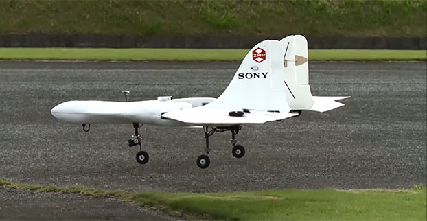
Sony is developing an unmanned aerial vehicle that lifts off and lands vertically like a helicopter (also known as a VTOL craft for vertical take-off and landing.) The VTOL drone is being developed with a Tokyo robotics firm under a collaborative company called Aerosense.
The drone can carry up to 22 pounds, fly continuously for two hours, and reach a speed of 106 miles per hour. Sony is developing it for business customers, who would use it for “measuring, surveying, observing and inspecting” as soon as next year, so it will likely carry different types of instruments, depending on the task a customer requires.
The video below shows a prototype flight on Monday.
Aerosense, created this month, is a joint venture between Sony and Tokyo-based startup ZMP Inc., which specializes in autopilot technology. The venture is part of Sony’s efforts to move beyond its core consumer products into enterprise markets. Aerosense will offer services such as inspecting aging infrastructure and surveying land that is difficult to access. The drones would be piloted automatically based on input from users about which areas they want surveyed.
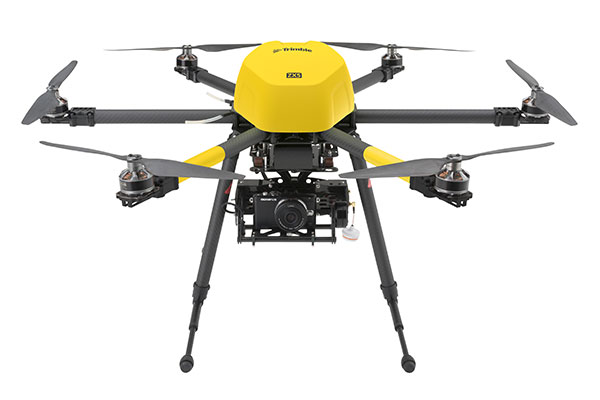
The Trimble ZX5 can reach smaller, remote environments faster, while providing accurate mapping data.
Trimble’s new ZX5 Multirotor Unmanned Aircraft System (UAS) — announced today — is an aerial imaging and workflow solution that captures and processes geo-referenced photo and video data for mapping, agriculture and inspection applications. The Trimble ZX5 complements the UAS portfolio with the ability to reach smaller, remote environments faster, while providing accurate mapping data for improved productivity in the field and back office, Trimble said.
“Unmanned aerial systems are powerful tools that are transforming geospatial-based mapping and inspection applications to positively impact our world,” said Todd Steiner, product marketing director in Trimble’s Geospatial Division. “Adding a multirotor solution to our portfolio provides options for our customers working across multiple environments to collect accurate spatial data, transform it to intelligence and create deliverables.”
With the ZX5, Trimble extends its unmanned aerial portfolio to include both fixed-wing and multirotor solutions, providing customers with a choice to meet their specific requirements. Trimble’s fixed-wing UX5 provides longer flight capabilities for large, open environments including farms, mines, canals, flood areas and forests — while the ZX5 is more suited for mapping smaller sites, including facades, obstructed areas, construction sites and standard aerial mapping applications.
The Trimble ZX5 multirotor UAS.
The ZX5 Multirotor is built for everyday jobs where image capture from tight spaces is common. Its vertical takeoff and landing capabilities allow users to work in tight places and obstructed environments where fixed-wing solutions are less suitable. It requires no launcher, is easy to assemble and includes everything needed to capture high-quality geo-referenced photos for aerial mapping and inspection applications.
The ZX5 includes a 16-megapixel camera to capture high-quality aerial imagery, down to 1-mm ground sample distance. The ZX5 also can be equipped to capture live video imagery for civil infrastructure, utility and oil and gas pipeline inspections.
Data captured by the ZX5 can be imported into Trimble Business Center Photogrammetry Module software to create detailed ortho-photos, digital elevation models, point clouds, volume calculations and 3D models, all without requiring specialized photogrammetry knowledge or experience. It also integrates with Trimble’s Inpho UASMaster module for advanced photogrammetric processing.
In addition, the Trimble ZX5 has been granted a Section 333 exemption from the Federal Aviation Administration.
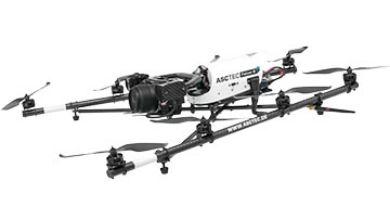
Topcon Positioning Group announces a worldwide distribution partnership with unmanned aerial system (UAS) provider Ascending Technologies. The agreement gives Topcon exclusivity for the global distribution of the AscTecFalcon 8 rotary-wing model, plus the GeoEXPERT and the InspectionPRO sensing and feature packages.
“We are excited to add the brand new Topcon Falcon 8, powered by Ascending Technologies, to our scope of aerial mapping solutions,” said Eduardo Falcon, executive vice president and general manager for the Topcon GeoPositioning Solutions Group. “By distributing both core target models on a worldwide level, Topcon can offer more end-users the flexibility and proven advances that these patented rotary-wing systems provide for survey, inspection and monitoring applications.” The Topcon-branded UAS includes the latest AscTecTrinity autopilot technology.
Based in Germany, Ascending Technologies is a developer and manufacturer of micro UAS for professional, civil and research use. “The AscTecFalcon 8 has been in series production since 2009 and still is the first choice UAS of world market leading inspection and surveying service providers,” said Jan Stumpf, one of the four CEOs and co-founder of Ascending Technologies.
“We are proud that our proven and advanced technology can now be easily accessed throughout the world. With the help of Topcon and its reseller network we can provide our high standards of support and customer service everywhere. This partnership gives us the freedom to continue the development of game changing technologies our customers need, while quickly extending our active fleet of reliable UAVs,” said Stumpf.
CartoPac International and EDM International have implemented a new transmission line inspection solution based on the CartoPac Software platform for the Western Area Power Administration. Western markets and delivers hydroelectric power within a 15-state region of the central and western U.S.
Western sought quotes for a commercial-off-the-shelf (COTS) utilities inspection software application that would provide a more efficient, integrated process and technology for improving Western’s transmission line inspection practices/process. Teaming with EDM, CartoPac was awarded the contract to deploy the CartoPac software platform, configure the COTS solution to meet specific needs for Western, and provide training to field personnel for use of the new system.
With the COTS solution, Western now has a fully integrated application within their Esri GIS system, leveraging Windows OS field computers for field inspection of transmission lines. The CartoPac solution provides Western linemen with complete, streamlined access to data needed in the field. Using ruggedized laptop computers, field personnel have access to a complete suite of tools, including GIS maps and digital inspection forms to perform the required inspection tasks in the field. CartoPac provides a streamlined process for data transfer in and out of the system, and provides a standardized, centralized application across all of Western. In addition, the new solution provides tools for GIS, foremen, and other key stakeholders to review, validate, and report on critical information.
Through the partnership established with EDM, CartoPac and EDM were able to provide a proven enterprise mobile technology, combined with expertise and experience in the electric transmission inspection and maintenance arena. EDM provided configuration and training of the solution using experienced subject matter experts, trained in configuration of CartoPac technology, with knowledge and experience in transmission line inspection and maintenance. The combination of the existing COTS CartoPac platform and EDM’s experienced personnel has created an electric industry offering with a highly flexible software platform and industry proven workflows.
CartoPac is hosting two webinars on the utility industry:
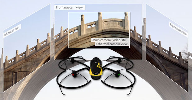
Swiss professional drone maker senseFly has launched the eXom, its new quadcopter UAS for mapping and inspection. The eXom is available to pre-order immediately and ships this summer.
The eXom is a sensor-rich system, sensefly said. Developed by experts working across numerous fields of robotics, this lightweight quadcopter offers professionals such as civil engineers and land surveyors the situational awareness, imaging flexibility and durability they need to complete challenging tasks safely, accurately and efficiently.
“We believe the eXom’s level of application-focused technology is unique in the civilian drone market,” said Antoine Beyeler, CTO and co-founder of senseFly. “This platform tightly integrates several one-of-a-kind features, such as TripleView imaging, advanced situational awareness and full flight mode flexibility — to provide inspection and mapping professionals with the functionality they desire from a rotary system.”
eXom is a future-ready platform with a quad-core computer onboard, senseFly said. Like senseFly’s fixed-wing drones, it offers users evolving performance through regular software updates, adding the latest drone tech innovations to keep the eXom at the cutting edge for years to come, the company said.
eXom’s low take-off weight of 1.7 kg (3.7 lb) ensures its users will, in many countries, have less flight authorization paperwork to deal with than those who use heavier systems.
The eXom’s advanced integrated sensors work together to provide the user with full situational awareness and support obstacle avoidance:
Five navcam vision sensors allow the operator to see in the direction the drone is moving, automatically via its flight control software, without needing to turn the system’s TripleView camera head. This technology is similar to the visual parking sensors in modern cars, but brought into a 3D flight environment.
Five ultrasonic proximity sensors work in harmony with eXom’s navcams to ensure the operator always knows the drone’s distance from nearby objects. (The drone’s shock-absorbent carbon fibre shrouding is also always on hand to protect its rotors in case of surface contact.)
Numerous other sensors, including inertial measurement units, barometers, magnetometers, GPS and magnetic encoders, maximize the drone’s stability and safety.
eXom’s autopilot-controlled TripleView camera head enables the user to view and record three different types of imagery during a single flight without needing to land to change cameras:
HD video
Ultra high-resolution stills
Thermal still/video
Because the TripleView head faces forwards, eXom can fly up close to target structures such as building walls and dams to achieve sub-millimeter data resolutions. Plus, with the head’s 270-degree vertical field of view, users can document objects positioned directly above and below the drone — crucial for tasks such as bridge and roof inspections.
eXom offers various flight modes:
Autonomous mode — for mapping projects. First, create a flight plan using eMotion X’s mission blocks. eXom then launches, flies, acquires geo-referenced imagery and lands itself.
Interactive ScreenFly mode — this streaming video mode is for live inspection tasks. Use the supplied joypad to navigate and orient the drone via computer screen. This mode includes flight assistance features such as cruise control and distance lock.
Create a flight plan, launch in autonomous mode, then go live on demand.
No matter which mode is activated, RC-based manual control always remains available as a backup function and for experienced pilots.
Visit senseFly at Unmanned Systems 2015: Hall B2, Booth 519. The eXom will be demonstrated in flight at the senseFly booth at at the show’s Air & Ground Demo Area (demo timings: May 6, 12:15 and 14:15, May 7, 11:45 and 14:15).