Trimble has introduced data integrity monitoring for CenterPoint RTX Fast, its precise point positioning (PPP) correction service.
The Trimble RTX Integrity monitoring system is an innovative, patented solution, built in direct response to client requirements for production-ready applications. It continuously validates the reliability of correction data processed by the network, which is broadcast to users in the agriculture, geospatial, construction and automotive industries, ensuring positioning data is right the first time.
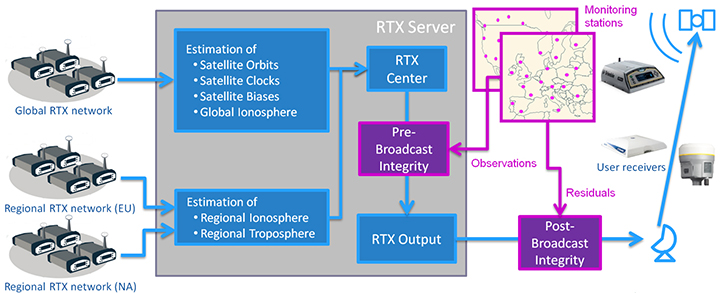
Through a two-step process, the Trimble RTX Integrity system verifies the integrity of GNSS data and filters faulty information in the network server before the data is broadcast. A secondary post-broadcast check is conducted on the entire data transmission process where additional errors may be detected and removed.
The integrity monitoring system is fully automated and reacts in seconds to detect, isolate and block faulty data to provide even more highly accurate and reliable positioning.
Trimble RTX Integrity is comprised of independent monitoring stations strategically positioned across RTX Fast networks in the United States, southern Canada and across Europe. These stations continuously monitor data output during multiple stages of the Trimble RTX positioning process. Any suspicious satellite data is removed during the integrity protection process and positioning is calculated using only validated data.
Trimble Alloy GNSS reference receivers power the independent monitoring stations using redundant internet connectivity for added reliability. To date, no other positioning network offers the same level of data integrity validation across such expansive, contiguous geographies.
Trimble RTX Integrity monitoring system was developed in accordance with Automotive Software Performance Improvement and Capability dEtermination (ASPICE) and ISO 26262 automotive safety standards, making it easy to integrate into major automotive manufacturers’ autonomous driving systems.
Trimble RTX Integrity can also be used by Trimble’s customers in the agriculture, geospatial and construction industries to ensure correction stream integrity and reliability for applications such as machine control and high-accuracy surveying applications.
“Trimble remains committed to exceeding expectations by providing accurate corrections to our customers to support safety-critical and other day-to-day applications,” said Patricia Boothe, SVP of autonomy, Trimble. “Implementing additional checks and balances to ensure our data is authenticated, trustworthy and accurate is of paramount importance to maintaining the integrity of our RTX network and instilling confidence with our users that the data is correct.”
The Trimble CenterPoint RTX correction service, enabling centimeter-level absolute positioning around the world without the need for RTK reference-station infrastructure, is now available to many users, including integrators of professional high-precision equipment and consumer products such as in the automotive sector. Access is provided via a software library compatible with any GNSS device. The corrections now contain detailed integrity information for safety-critical applications.
The RTX infrastructure is made up of approximately 120 globally distributed RTX reference stations. Receivers at these stations transmit measurement data at 1 Hz to the RTX server centers, where the correction data is computed. For redundancy purposes, multiple servers in the United States and Europe are operated. A failsafe architecture avoiding any single point of failure in the processing chain has produced a very high availability of corrections. Today the system supports GPS, GLONASS, Galileo, BeiDou and QZSS satellites. It is a multi-frequency system supporting two or more frequencies for each satellite system.
The correction stream is available to users using L-band signals broadcast via geostationary satellites and IP connections. The L-band transmitted RTX data stream uses a bandwidth of 600–2400 baud, and a highly compressed data format with a resolution of 1 millimeter, with an average latency of 8 seconds in L-band mode and 5 seconds in IP mode. The data stream is encrypted via an Advanced Encryption Standard (AES) with a key length of 256 bits to guarantee safe transmission. Data transmission integrity is assured with a 32-bit cyclic redundancy check attached to every message. The RTX correction stream provides information on satellite position, satellite clock, ionospheric and tropospheric models, and code and phase biases.
The orbit determination is done in real time using a reduced dynamic approach with dynamic models and exploiting the accuracy of the phase measurements after ambiguity fixing. Based on the computed orbits, the satellite clocks are estimated at 1 Hz, where integer ambiguity fixing is performed for the different satellite systems.
Next, a single-layer global ionospheric model is computed and represented through spherical harmonics. There are currently two areas with a denser network than the global network; these cover Europe and the mainland U.S. with more than 1,000 base stations. Using these stations, regional ionospheric and tropospheric models are computed, which then provide a fast convergence (RTX-Fast service).
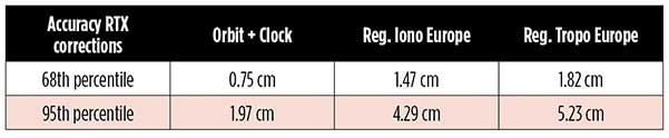
The satellite position and clock information has centimeter accuracy and allows the client to compute precise point positioning (PPP) with carrier-phase ambiguity resolution. Table 1 shows service accuracy.
Table 1. Accuracy of the RTX corrections from more than three years (June 2015–July 2018) of residuals computation in the European RTX-Fast network. (Table data: authors)
Once the ambiguities are resolved, the position solution is accurate to a few centimeters. The global RTX-Standard service provides convergence times of 7 minutes to 20 centimeters (cm) horizontal error (95%) and to 2.5 cm (95%) in 13 minutes as shown in Figure 2. The regional RTX-Fast service (U.S., Europe) provides convergence times of less than a minute with centimeter accuracy. The warmstart convergence time is approximately 13 seconds.
Figure 2. Global convergence of RTX out of 52 globally distributed stations covering one month of data. (Image: Trimble)
The accuracies specified are achievable with precise Trimble GNSS positioning hardware. For integration into non-Trimble devices, an RTX software library is offered, which gives the user real-time access to the individual data in the RTX correction stream. For use of this library in safety-critical systems such as advanced driving-assisted systems (ADAS) or semi-automated driving, this library was certified to follow the ASIL-B ISO 26262 standard and the automotive ASPICE standard. This library is available for easy integration into third-party applications.
In addition to the real-time RTX solution, a web-based post-processing solution is available for public use free of charge. It is possible to upload static Trimble or RINEX files to the server, post-process the measurement data, and retrieve a precise position in various coordinate frames.
Service integrity is continuously monitored at independent stations from the RTX tracking networks in Europe and the US. The integrity of the service is provided at the correction data domain. The integrity monitoring part of the RTX system minimizes the risk due to events such as unplanned satellite maneuvers or wrong broadcast ephemeris; satellite signal or clock anomalies; ionospheric storms; or problems in transmitting the RTX correction stream.
The monitoring stations compute phase observation residuals (with ambiguity fixing) using the station measurements and the received RTX corrections. These residuals represent the actual errors of the corrections as seen by the monitoring stations at the line-of-sight (Table 1). The thresholds at which corrections are considered as faulty are the following: 0.5 m + QI (quality indicator) for orbit + clock corrections and regional tropospheric models, and 1.0 m + QI for regional ionospheric models.
The integrity monitoring consists of two steps (Figure 1): a pre-broadcast check, where potentially faulty corrections are detected and filtered out before leaving the computing server, and a post-broadcast check, where additional errors in the transmission channel are detected and alarms are issued to the users.
Figure 1. Generation and transmission of RTX global and regional corrections, including pre- and post-broadcast integrity monitoring. (Image: Trimble)
Integrity flags and alarms are constantly inserted into the correction stream and output by the RTX client library. The integrity information notifies clients of the presence of integrity monitoring and provides timely alerts in case of detected correction-data integrity violations. The time-to-alert limit goals are 17 seconds for L-band transmission and 13 seconds for IP transmission for the RTX service.
The RTX corrections includes quality indicators. In particular, the quality indicator for the satellite clock includes a “DoNotUse” flag to indicate potential problems with the given satellite. This flag prevents the use of the satellite for positioning when received by the user. The quality indicators of the corrections are indeed a first integrity layer. In 2017 the pre-broadcast integrity monitoring was added to act as a second layer. In 2019, with the addition of the post-broadcast integrity monitoring, a third integrity layer was added to the RTX correction data stream.
The RTX system provides access to centimeter-level corrections allowing centimeter positioning on a global basis. RTX-Fast services are available in Europe and the U.S. with pre- and post-broadcast integrity monitoring currently being deployed.
The authors are engineers with Trimble Terrasat GmbH, Germany.
Integrity Monitoring of LTE Signals of Opportunity-Based Navigation for Autonomous Ground Vehicles
By Mahdi Maaref, Joe Khalife and Zak M. Kassas/University of California, Riverside
FIGURE 1. RAIM framework for LTE-based navigation without GNSS signals. (Images: Authors)
Proprietary receivers and navigation frameworks for autonomous ground vehicle (AGV) navigation with long-term evolution (LTE) cellular signals demonstrate meter-level accuracy with standalone LTE signals and lane-level accuracy with LTE signals coupled with other sensors (inertial and lidar).
As the number of systems that rely on cellular signals for navigation grows, the need for monitoring the integrity of their navigation solution becomes essential.
This paper proposes a receiver autonomous integrity monitoring (RAIM) framework for AGV navigation with LTE signals of opportunity. Experimental results evaluate the efficacy and accuracy of the proposed RAIM-based fault detection and exclusion technique, demonstrating a reduction of 22% in the position root-mean-squared error (RMSE).
FIGURE 1 demonstrates the RAIM framework: (a) When GNSS signals are unusable, LTE signals are used for navigation and integrity measures are calculated; (b) simulation results of downtown Riverside, California, where the black regions represent areas where multipath is expected to exceed 0.5 meters; (c) experimental setup; (d) environment and location of LTE towers; and (e) experimental results showing severe multipath being autonomously detected and excluded.
The estimation error represents the difference between the ground truth from an RTK GNSS-IMU system and our LTE-IMU system.