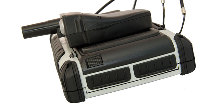
Lance Andrew of CHC Navigation showcases its LT500 series and integrated head while at InterGeo 2014 held October 7-9 in Berlin.
Tag: INTERGEO 2014
-
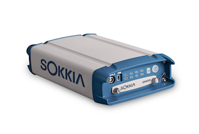
Sokkia Announces Next-Generation Geodetic Reference Receiver
The Sokkia GNR5 geodetic receiver. Photo: Sokkia Sokkia announces the latest addition to its line of geodetic GNSS reference receivers — the GNR5. Making use of 452 channels optimized to track the full GNSS spectrum, the GNR5 is designed to assign any visible signal to any available receiver channel.
“The GNR5 is a comprehensive connectivity solution,” said Charles Rihner, vice president of the GeoPositioning Group. “Whether using the built-in Bluetooth and Wi-Fi wireless communication options, or standard Ethernet, serial and USB connections — the system provides a powerfully integrated reference station that is capable of tracking the GPS, GLONASS, Galileo, Beidou, QZSS and SBAS constellations.”
Additional features include high-precision code and carrier phase measurements up to 100 Hz, Power over Ethernet (PoE), and advanced receiver management features.
The new receiver is on display at InterGeo 2014, being held this week in Berlin.
-
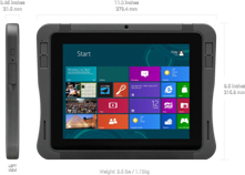
Altus, Entegra Combine to Provide Tough Tablet with RTK Positioning

The APS-GeoPod. Photo: Altus Positioning Systems Altus Positioning Systems, a Septentrio company, has integrated its APS-GeoPod product with Entegra Technologies’ Crossfire Pro Tablet. This collaboration, targeting the oil and gas, survey, GIS and transportation industries, provides a high-performance tablet-based solution for enabling ultra-precision RTK of sub-meter or centimeter accuracy.
Altus is showcasing the APS-GeoPod and Crossfire Pro tablet, along with the full range of Altus products, at booth A1.060 and outside Booth FG.006 at InterGeo 2014 being held this week in Berlin, Germany.
According to Altus CEO Neil Vancans, the Altus APS-GeoPod and the Entegra Crossfire Pro Tablet provide a combination of precision, performance and features that make it ideal for energy services, land surveys and other GIS-related applications.
APS-GeoPod is a compact GPS/GLONASS RTK and DGNSS receiver that adds high-precision RTK positioning to USB-compatible tablet PCs. “This unique product gives users the convenience of adding RTK precision to any on-board application on mobile devices geared to the field service professional,” Vancans said.
The Entegra Crossfire Pro tablet. Photo: Altus Positioning Systems APS-GeoPod features include:
- Compact dual-frequency GNSS module
- Low power consumption (<1 Watt)
- USB 2.0 interface
- Internal L1 GPS/GLONASS antenna
- NMEA integration with GIS software
The Crossfire Pro tablet features the multi-touch interface and communication capabilities of smartphones, the large display and ergonomics of consumer tablets, and the daylight-readable screen and durability of rugged tablets. Safety features include UL 1604 Class I/Division II certification for operation in hazardous locations. To users, Crossfire Pro delivers a customizable tablet for exacting daily activities, resulting in greater efficiencies, response times, productivity and customer service levels, the companies said.
Crossfire Pro tablet features include:
- ADAPTIVE PERFORMANCE — Powerful, latest-generation processors, wireless communications, connectivity, and outdoor-viewable displays
- ADAPTIVE EXPANSION — Standard and custom expansion modules — tailored to suit your workflow
- ADAPTIVE CONNECTIVITY — Flexible user interactivity, including multi-touch displays (finger, glove and stylus), configurable I/O ports, clamshell keyboard and smart docking stations
- ADAPTIVE RUGGEDIZATION — Variations in ruggedness to stand up to drop, shock, moisture, dust, temperature, and more.
-
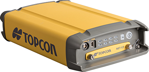
Topcon Announces Geodetic Reference Receiver and Antenna

Topcon’s NET-G5 receiver and CR-G5-C antenna. Photo: Topcon Topcon Positioning Group announces the next generation of its geodetic GNSS reference receivers and antennas — the NET-G5 receiver and CR-G5-C antenna.
The announcement was made at InterGeo 2014, being held this week in Berlin.
Using Vanguard and Universal Tracking technologies, the NET-G5 receiver incorporates 452 channels capable of tracking the full GNSS signal spectrum, including modernized GPS, GLONASS, Galileo, Beidou, QZSS and SBAS signals. Universal Tracking has the advantage and capability to assign any visible GNSS signal to any available receiver channel.
The NET-G5 receiver is designed to work as a complete system connectivity solution, with built-in Bluetooth and Wi-Fi, for flexible wireless communications or via standard Ethernet, serial and USB connections. Other features include: High-precision code and carrier phase measurements up to 100 Hz; Power over Ethernet (PoE) and an all new Topcon receiver web interface with advanced receiver management features.
“Comprehensive communication support, advanced web-server capability, and extended operating times are among the new features supported on the NET-G5. Coupled with the CR-G5-C antenna, the new systems provides a powerful, interference protected network solution,” said Charles Rihner, vice president of the Topcon GeoPositioning Group.
“Whether you are installing an all-new GNSS network infrastructure, expanding or upgrading an existing network, looking for a premium campaign receiver or stand-alone RTK base station, the high-performance NET-G5 is designed to provide the most advanced reference station solution available in the market,” Rihner said.
The CR-G5-C is a full-wave geodetic choke-ring antenna designed to address evolving requirements for reference networks and infrastructure monitoring applications. “The CR-G5 antenna has excellent vertical phase center stability over the entire GNSS frequency band, providing superior performance in tracking low elevation satellite signals,” Rihner said. “This new model employs cavity filter technology to more aggressively combat radio frequency interference in difficult environments.”
-
Spectra Precision Launches Central Cloud Service, New Software Versions
Spectra Precision introduced a new cloud computing service for Spectra Precsion applications. The company also announced new road modules for version 5.5 of its Survey Pro software and for Spectra Precision Survey Office.
The announcements were made at InterGeo 2014, being held this week in Berlin.
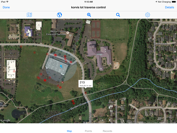
Spectra Precision Central is a new cloud computing service. Photo: Spectra Precision Spectra Precision Central. A dedicated cloud computing service for Spectra Precision survey applications, Spectra Precision Central offers survey teams in the field and office the ability to rapidly exchange survey and project data with team members when and where it is needed.
“Spectra Precision Central is a straightforward and uncomplicated solution that offers significantly improved data management efficiency for virtually any size land survey firm,” said Olivier Casabianca, Spectra Precision business area director. “Field crews can store project data to a Central account in the cloud using a data collector with Survey Pro, a connected computer or most smartphones and have the data immediately available to other work groups in the field or office. All data is synchronized for either online or offline use by any connected office computer and data collector.”
As part of the Spectra Precision Central service, users can download Survey Pro Central, a free smartphone app, which enables iOS and Android devices to connect directly to the Spectra Precision Central system. Survey Pro Central provides another easy way to access documents, upload and download files, and manage survey data. Survey Pro Central also supports a coordinate viewer, a raw data viewer, and a map display that can also use Google maps. Whatever sensor is being used, a total station or GNSS receiver, the Spectra Precision Central system provides the hub to permit crews to transfer and share data through their Central cloud account.
A one-year Spectra Precision Central license is included with the purchase of any model Spectra Precision data collector with Survey Pro. Each Central account can have as many users and logins as the business requires. Maintaining the Survey Pro extended warranty annually automatically renews the license. Data in the account is always available, even if the subscription expires, by simply synchronizing the data in the Central cloud to the office computer.
Survey Pro Version 5.5. Spectra Precision Survey Pro version 5.5 now includes a new road module and integration with Spectra Precision Central. Survey Pro version 5.5 is the latest release in 20 years of continuous development.
Survey Pro version 5.5 is fully integrated with the new Spectra Precision Central cloud system. Files can be automatically or manually synchronized to the cloud which then synchronizes data back to the office or smart phones. This new feature provides access to a user’s data whenever they need it and provides an off-site backup service for valuable data.
The new road module is used for importing, managing, and staking roads. The module directly supports the data from the new version of Spectra Precision Survey Office. Now roads can be designed in Survey Office, exported to Survey Pro on the data collector, and staked in the field providing a complete system. The new system includes a number of improved and enhanced features as well as new graphic and data views.
Other features include a new GNSS interface to improve workflows, a new multi-point backsight setup routine, and many other enhancements.
The new version will be available for all customers who are current with a maintenance plan. Customers who are not current can purchase a new maintenance plan to get the latest updates including a Spectra Precision Central account.
Spectra Precision Survey Office. Spectra Precision Survey Office (SPSO) now includes support for advanced roading that allows for allows for the creation, import, export and edit of corridors and roads.
The new roading module allows users to create cross-sections, create points at intervals, add in material layers and the ability to create and edit templates. This allows for the integration of Survey Pro field software and SPSO office software for a complete solution.
In addition to roading, the SPSO software now includes traverse adjustment, importing of Esri Shapefiles, additional geoid modules, smooth curve feature code and import and export functionality for FAST survey job files.
-
New Trimble Products Focus on Geospatial Imagery
Trimble introduced several new products at InterGeo 2014, being held this week in Berlin, with a focus on incorporating data from photographs and imagery into geospatial databases.
Trimble also offered an expanded GNSS portfolio for surveyors that includes the Trimble NetR9 Geospatial receiver; the Trimble Geo7X with Trimble Access field software onboard; and enhanced Trimble xFill functionality that provides continuous RTK level accuracy when paired with a Trimble CenterPoint RTX subscription. The new additions offer surveyors more flexibility in the field to meet a variety of work requirements. Learn more here.

Photo: Trimble Inpho version 6.0. Trimble announced a new version of its photogrammetric software suite, which provides highly automated workflows for photogrammetry and remote sensing professionals so they can process thousands of airborne images with high precision. Inpho version 6.0 increases efficiency by reducing project turnaround times and improves the quality of deliverables via new automated and interactive tools and satellite triangulation functionality.
A new satellite triangulation function in Inpho version 6.0 allows professionals to quickly generate deliverables from satellite imagery data and expand their capabilities, addressing the needs of industries such as environmental, forestry, agriculture and land management. Automatic tie point extraction and bundle block adjustment provides improved orientation of satellite images. The highly automated process results in a significant reduction in office processing time so projects can be delivered with quality precision in a shorter turnaround time.

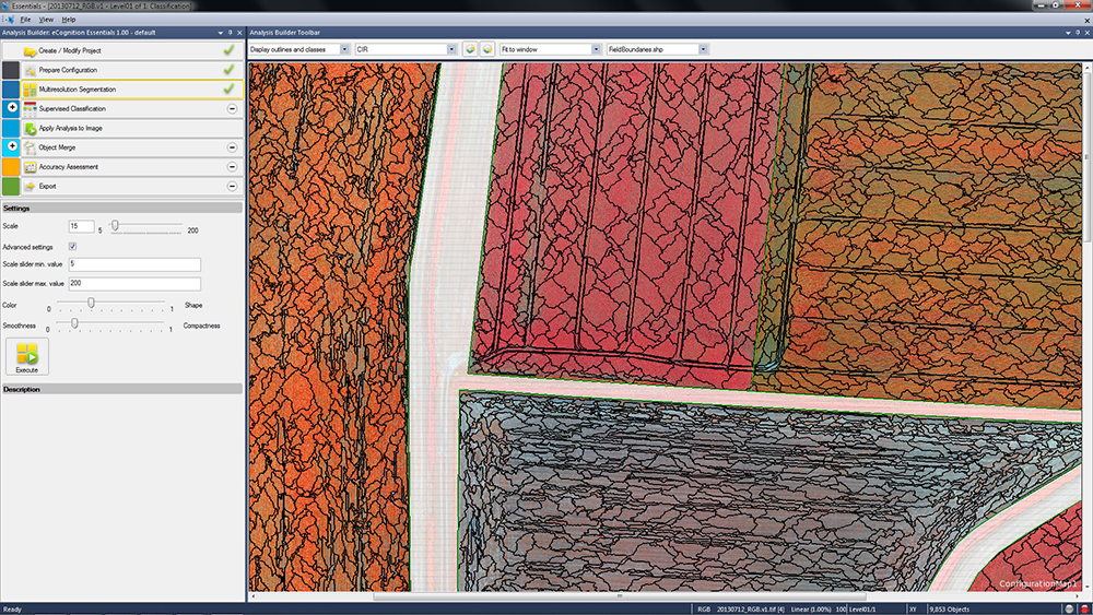
Photo: Trimble eCognition Essentials. eCognition Essentials is a new software solution for geospatial and remote sensing professionals performing land-cover mapping tasks using satellite imagery. eCognition Essentials offers an intuitive image analysis solution that allows users of all levels to quickly produce high-quality, Geographic Information System (GIS)-ready deliverables.
Leveraging core eCognition software technology, eCognition Essentials is easy to use with its simplified and intuitive interface. eCognition Essentials reduces analysis error as it applies predefined and structured rules to analyze and transform imagery data into relevant geospatial information. The new automated image analysis functions — such as image segmentation or sample-based classification — combined with a set of interactive tools for quality control offer users a streamlined workflow for quicker project turnaround times.
Trident version 7.0 is a new version of the mobile data analysis software designed to efficiently manage, interpret and extract features from digital images and point cloud data collected via land mobile systems. Enhancements in the new version significantly reduce the time required for geospatial professionals to transform land mobile sensor data into relevant geospatial information used in civil engineering, transportation and GIS mapping. In these applications, Trimble Trident can be used for surface modeling, roadway sign and pole detection, lane marking detection, edge and breakline detection, road geometry and clearance measurements.
Trident version 7.0 offers increased automation functionality to deliver results more quickly. Updated feature extraction tools within the software provide greater reliability and minimize manual editing and verification. Trident version 7.0 breakline detection routines now include a cross-sectional workflow for rapid and progressive development of supervised roadway breakline models.

Photo: Trimble Trimble V10 Imaging Rover. The Trimble V10 is an integrated camera system that precisely captures 360-degree digital panoramic images for visual documentation and measurement of the surrounding environment. Enhancements include additional integration options and high-dynamic range (HDR) imagery. The Trimble V10 offers an accessible and efficient means of visually documenting site conditions to perform measurements in the office, produce more powerful deliverables and speed up decision making for managers on or off the site.
In addition to the R10 GNSS receiver, the Trimble V10 Imaging Rover now seamlessly integrates with Trimble’s R-Series GNSS receivers — the Trimble R8, R6 and R4 — and TSC3 controller. Through this seamless integration, geospatial professionals can easily capture high-quality, geo-referenced panoramic images to document the surroundings. Now more Trimble customers can take advantage of the Trimble V10’s powerful capabilities. In addition, a new two-piece power rod option enables easy transportation of the Trimble V10.
-
Trimble Offers Pipeline Construction Software for Oil and Gas

The Trimble Access Pipelines launcher. Trimble announced today an addition to its Trimble Access family of field software applications: Trimble Access Pipelines. Designed for surveyors involved in oil and gas pipeline installation, Trimble Access Pipelines addresses challenges encountered by pipeline surveyors by automating common pipeline survey tasks. The software solution saves time by simplifying attribute and inventory collection and integrating all the data into one easy-to-use data collection workflow.
The announcement was made today at InterGeo 2014, the world’s largest conference on geodesy, geoinformatics and land management.
Trimble Access Pipelines, a new addition to the ever-increasing suite of applications available for Trimble Access field software, offers a streamlined workflow for pipe inventory collection and validation, weld mapping and as-built measurements. The software significantly reduces project time and redundancies by collecting pipe attribute data, recording the relationship between welds and pipes, and electronically linking the joint attributes to measured welds. Using the application, pipeline surveyors can capture the necessary data so construction can proceed without costly delays.

The complete end-to-end solution is enabled when combining the power of Trimble Access Pipelines and Trimble Business Center. Trimble Access Pipelines can quickly generate customized reports for the tally and weld map data or the surveyed pipeline directly on the controller. All field data can be seamlessly transferred into Trimble Business Center to produce rich, complete deliverables including as-built plots using the Trimble Business Center Advanced Drafting module.
“One of the most time consuming challenges pipeline surveyors face is the collection of pipe attribution detail and recording the information with weld positions,” said Benoit Mallen, business area manager of Oil and Gas for Trimble’s Geospatial Division.”With Trimble Access Pipelines, we have leveraged Trimble’s strength in positioning technology and combined it with a workflow-specific application to create a streamlined solution that can meet the needs of geospatial professionals working in the oil and gas industry.”
Trimble Access Pipelines and Trimble Business Center Software version 3.30 are available now through Trimble’s Geospatial Distribution Channel.
A free trial of the Trimble Access Pipelines application as well as other available modules for Trimble Access are available to all existing Trimble Access users, and can be activated and installed using the Trimble Access Installation Manager. For more information on Trimble Field software, visit www.trimble.com/Survey/Field-Software.
-
Trimble Offers Expanded GNSS Portfolio for Surveyors
Trimble has introduced additions to its GNSS portfolio — the Trimble NetR9 Geospatial receiver; the Trimble Geo7X with Trimble Access field software onboard; and enhanced Trimble xFill functionality that provides continuous RTK level accuracy when paired with a Trimble CenterPoint RTX subscription. The new additions offer surveyors more flexibility in the field to meet a variety of work requirements.
The announcement was made today at InterGeo 2014, the world’s largest conference on geodesy, geoinformatics and land management.

The Trimble NetR9 Geospatial GNSS Receiver. Photo: Trimble Trimble NetR9 Geospatial GNSS Receiver. The Trimble NetR9 Geospatial has been configured as a comprehensive modular GNSS receiver for the professional survey market. The lightweight form factor of the NetR9 comes fully loaded with performance enhancements including: Trimble HD-GNSS technology, Trimble 360 technology, Trimble CenterPoint RTX correction service support and Trimble xFill technology. The combination of these capabilities provide a powerful solution that delivers accurate positioning and support for all existing and currently planned GNSS constellations, and continuous RTK-level precision during interruptions of the primary correction source, Trimble said.
Serving as either a rover or mobile base station, the NetR9 Geospatial offers the flexibility to choose a GNSS antenna and radio solution that matches the surveyor’s specific workflow needs. “Trimble’s GNSS solutions are designed to meet the unique requirements of surveyors,” said Elmar Lenz, business area director of GNSS Solutions for Trimble’s Geospatial GNSS Division. “These solutions provide professionals in the survey and engineering industry with flexible tools to stay productive and competitive, delivering the appropriate solution for any survey project that’s being completed, no matter where our customers work and survey.”
Trimble Geo 7X with Trimble Access. Designed for surveyors facing a variety of workflow requirements to accomplish both high-accuracy surveying and handheld point measurement, the Geo7X is now available with Trimble Access field software onboard. With Trimble Access onboard the Geo7X, surveyors benefit from a familiar, easy-to-use software interface that provides common survey workflows directly on their GNSS handheld, resulting in increased data collection efficiency.
The Geo7X is a dedicated network rover that can be used on a survey rod with an external antenna for survey-grade accuracy. If the surveyor prefers the convenience of a highly mobile handheld solution, they can snap if off the rod and switch to the internal antenna. In this mode, they also have easier access to other features such as the integrated camera for collecting attribute data.
Trimble xFill in use. Photo: Trimble Expanded Trimble xFill Functionality. Expanded xFill functionality, available in the Trimble R10 GNSS receiver and NetR9 Geospatial receiver, allows surveyors to continue collecting data with centimeter accuracy indefinitely throughout their workday when the connection to the base station or VRS network is lost. The expanded xFill functionality is enabled via a CenterPoint RTX subscription.
Without a Trimble CenterPoint RTX subscription, xFill maintains RTK level accuracy for up to five minutes during interruptions in the primary terrestrial correction stream. This basic xFill functionality is included with the Timble R10 GNSS system and is now included with the NetR9 Geospatial GNSS receiver.
“With expanded accuracy levels and seamless RTK/RTX transition, the Trimble R10 continues to offer unprecedented capability to the survey professional,” said Lenz. “Connectivity problems are traditionally one of the biggest GNSS-related challenges a surveyor will face while in the field and expanded Trimble xFill functionality significantly helps solve that problem, saving time and money.”
-
Carlson Software Introduces Surveyor2 Data Collector at InterGeo
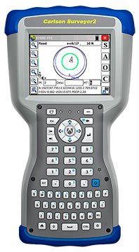
Photo: Carlson Software The Carlson Surveyor2, the newest model of Carlson Software’s Carlson Surveyor line of data collectors, was launched at the InterGeo Trade Show in Berlin this week.
The handheld surveyor is on display at Carlson’s Stand 1.037, Hall 1.1, at InterGeo.
Fast, durable and more powerful, the Carlson Surveyor2 is ruggedized, with an IP68 water and dust-resistant ingress rating. Still weighing two pounds, the Carlson Surveyor2 offers increased program memory (now 512MB) and increased non-volatile data storage (now 8 gigabytes), and a 1.0-GHz processor to provide the speed surveyors need in the field. It comes equipped with significantly increased Bluetooth range, up to 1500 feet when paired with a class I device.
The Surveyor2’s QWERTY keyboard eases data entry and is designed to be workable even for those with large hands or wearing gloves. The backlit keys and larger, brighter display screen allow users to work effectively in all lighting conditions.
“Not only did the Surveyor2 retain the durability of its predecessor, but its higher-resolution, easier-to-read display screen also comes with scratch-resistant glass,” said Bruce Carlson, president and founder of Carlson Software. “An added convenience is its enhanced battery life — up to 20 hours.”
The Surveyor2 has kept its easy-to-grip design, being thinner front to back than other data collectors when resting on a table top. The computer runs on Windows Mobile 6.5.3 and Carlson SurvCE 4.0 can be included. SurvCE is the powerful data collection software used around the world.
The Surveyor2 is designed for surveying, stake out, construction layout and GIS mapping. The easy-to-use, tab-based menu and advanced graphics in Carlson SurvCE 4.0 enhance the Carlson Surveyor2’s usability. Options include an integrated GSM cell modem for real-time connectivity, an integrated 5 MP camera with LED illuminator that doubles as flashlight, and a mapping-grade GNSS receiver.
-

Hemisphere GNSS Offers New Survey-Grade GNSS Antennas

The A25 and A45 antennas. Photo: Hemisphere GNSS Hemisphere GNSS has announced two low profile, multipurpose antennas that it says will exceed expectations in all GNSS applications. With unique filtering patterns and precise attention paid to mitigation of multipath and interference, the A25 and A45 antennas complement all GNSS products, from L1 GPS to multi-frequency, multi-constellation.
Both antennas are being featured at the InterGeo 2014 Conference and Trade Show in Berlin this week, at stand C2.007.
The A25 and A45 have been designed to support millimeter accuracy for land and marine applications. Both antennas support present and future GNSS signals, including GPS, GLONASS, BeiDou, QZSS, and Galileo. The A25 supports the previously mentioned signals at a single-frequency level, while the A45 supports these signals at a multi-frequency level.
“We’ve designed these antennas to excel in challenging environments such as near buildings or under foliage,” said Lyle Geck, senior manager of product marketing at Hemisphere GNSS. “They have superior multipath mitigation, stable phase centers and strong SNR’s, even at low elevations.”
The ruggedized housing used by both antennas is made of an aluminum base that has been pretreated for the marine environment and will withstand salt, fog, and spray. The antennas pass the two-meter pole drop test.
The A25 is a multi-GNSS precision antenna, designed for a variety of applications including GIS, single-frequency RTK positioning and navigation, and precision guidance. The A45 is a survey-grade, multi-GNSS precision antenna for a variety of applications including surveying, RTK positioning and navigation, precision guidance, and machine control.
For more information about Hemisphere GNSS’ antennas and other products, please visit www.hgnss.com/Products-Solutions.
-
Applanix Offers Single-Board GNSS-Inertial System for UAV Mapping
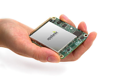
Photo: Applanix Applanix, a mobile mapping and positioning company, has introduced a new product that enables major improvements in unmanned airborne mapping: the Applanix APX-15 UAV GNSS-Inertial System. The announcement was made at InterGeo, being held this week in Berlin.
The APX-15 UAV is designed to maximize the efficiency of mapping from small unmanned aerial vehicles (UAVs) by reducing — or even eliminating — Ground Control Points (GCPs). Sidelap is also significantly reduced, increasing the area flown per mission. The Applanix APX-15 UAV provides performance in a small package and, with the included POSPac UAV post-mission software, produces a highly accurate position and orientation solution for direct georeferencing of cameras, LIDARs and other UAS sensors, the company said.
“Applanix has recognized the need to provide the growing UAS mapping market with the same highly efficient solutions that it pioneered for airborne mapping over 15 years ago,” said Joe Hutton, Director of Inertial Technology and Airborne Products at Applanix Corporation. “We are offering a cost-effective solution that meets the size, weight, power and cost requirements of small UAS, and maintains the Applanix pedigree for quality and performance.”
The APX-15 UAV, measuring just 6 cm x 6.7 cm and weighing only 60 grams, features a high-performance, survey-grade, multi-frequency GNSS receiver and low-noise MEMS inertial sensors all on a single board. The Applanix IN-Fusion GNSS-Inertial integration technology runs directly on the GNSS receiver, resulting in an ultra-compact design, while superior performance is achieved from the inertial sensors using the Applanix SmartCal software compensation technology.
With 220 channels, the APX-15 UAV tracks all available GNSS satellite signals including GPS L1/L2/L2C/L5 and GLONASS L1/L2, QZSS, BeiDou and Galileo, and provides a highly accurate post-mission and real-time RTK GNSS-inertial position and orientation solution to support guidance and control, precision landing and sensor geo-referencing.
APX-15 UAV is expected to be available worldwide in the first quarter of 2015 through the Applanix sales channel.
-
Live from InterGeo

Photo: GPS World GPS World staff will be reporting from InterGeo October 7-9. The massive trade show, held this year in Berlin, is considered the world’s leading conference trade fair for geodesy, geoinformation and land management. With more than 16,000 visitors from 80 countries, it is one of the key platforms for industry dialogue.
Staff members attending include GPS World Editor and Publisher Alan Cameron, Survey/GIS Editor Eric Gakstatter, and Digital Editor Joelle Harms. All three are accepting meeting invitations for companies interested in discussing their products and services. Contact [email protected].
VIDEO PLAYLIST
PHOTOS

Photo: GPS World 
Topcon demonstrates its LN-100W, an update to its line of 3D positioning systems designed for one-operator layout. Photo: GPS World 
German-based Multirotor by servicedrone is a UAV for professional 3D orthography. Photo: GPS World 
Attendees listen to a presentation on the show floor at InterGeo held October 7-9 in Berlin. Photo: GPS World 
Attendees watch UAV demonstrations at the conference’s flight zone. Photo: GPS World 
Attendees take a look at one of the many UAVs seen at InterGeo 2014 in Berlin. Photo: GPS World 
German-based Moskito GIS GmbH displayed a model from its 5 Power GIS. Photo: GPS World 
BRS Motorsport Formula Students from Bonn-Rhein-Sieg University of Applied Sciences showcase their simulator, sponsored by CPA ReDev. Photo: GPS World 
Riegl debuted and demonstrated its RiCOPTER UAV with LiDAR Integration. Photo: GPS World 
At dusk the night before the conference the moon overlooks the Brandenburg Gate, an 18th century arch in Berlin and one of its most well-known landmarks. Photo: GPS World BLOGS
InterGeo: The Worldwide GIS Showcase (09/25/14)
NEWS
Juniper’s New Rugged Handheld Designed for Data-Collecting Efficiency (10/10/14)
Sokkia Announces Next-Generation Geodetic Reference Receiver (10/08/2014)
Altus, Entegra Combine to Provide Tough Tablet with RTK Positioning (10/08/2014)
Spectra Precision Launches Central Cloud Service, New Software Versions (10/08/2014)
Topcon Announces Geodetic Reference Receiver and Antenna (10/08/2014)
New Trimble Products Focus on Geospatial Imagery (10/08/2014)
Topcon to Add 3D Mobile Mapping System to Product Lineup (10/08/2014)
Sokkia Introduces NET AXII Measuring Station (10/07/2014)
Topcon Announces Latest Addition to 3D Layout Line (10/07/2014)
Trimble Offers Expanded GNSS Portfolio for Surveyors (10/07/2014)
Trimble Offers Pipeline Construction Software for Oil and Gas (10/07/2014)
Carlson Software Introduces Surveyor2 Data Collector at InterGeo (10/07/14)
Carlson Launches GIS360 for Android at InterGeo (10/07/14)
Hemisphere GNSS Offers New Survey-Grade GNSS Antennas (10/07/14)
Applanix Offers Single-Board GNSS-Inertial System for UAV Mapping (10/07/14)
Icaros to Unveil Versatile Nadir/Oblique Aerial Mapping System at InterGeo (10/03/14)
InterGeo Event Considers Land Management Challenges (10/03/14)
Trend- and Media-Forum at InterGeo Features Innovation, China (10/03/14)
Juniper System, Soil Instruments Partner on Geotechnical Monitoring (10/03/14)
Oxford Technical Solutions Launches Board Set for System Integrators (10/03/14)
Orbit GT Showcases UAS Mapping Pro at InterGeo (10/03/14)
Icaros to Demonstrate Measuring Tool for Oblique Imagery at InterGeo (09/24/14)
EUROGI Conference to Be Held in Conjunction with InterGeo (08/11/14)
Join Us for Our Post-Show Webinar
New Product Trends in UAV, Survey, Mapping, and Geospatial Data Collection and Analysis
InterGeo Post-Show ReportThursday, October 16, 10 a.m. PDT/ 1 p.m. EDT / 5 p.m. GMT
Summary: UAVs (unmanned aerial vehicles) are taking over the surveying industry, thanks to their ever-improving sensors and the fact that they are getting lighter and can therefore remain in the air for longer. They complete surveying and inspection tasks that would otherwise be difficult to tackle, and do so with impressive cost-efficiency. UAV trends and technology will be among the focal points at the InterGeo conference in Berlin in early October.
Our correspondents will return with a fresh report, moderated by GPS World Editor and Publisher Alan Cameron and Survey Scene Editor Eric Gakstatter.