Spectra Precision has launched a new brand identity and name for its survey and geographic information systems (GIS) suite of solutions. The organization will now be known as Spectra Geospatial.
The announcement was made at Intergeo 2018, the conference on geodesy, geoinformatics and land management, taking place Oct. 16-18 in Frankfurt, Germany.
The new Spectra Geospatial brand builds upon the reputation and equity built under the previous Spectra Precision identity and now reflects the organization’s evolution of providing a broad range of solutions specifically focused on the geospatial industry, the company said.
“We’ve built a strong reputation for quality and innovation over the past 25 years,” said Olivier Casabianca, general manager of Spectra Geospatial. “We are very proud to bring a new name and brand to the market that accurately reflects our customer and dedication to the industry.”
Spectra Geospatial delivers products to the survey, GIS and construction markets, with the brand offering a complete product portfolio including GNSS, GIS, optical total stations, data collection hardware, and field and office software.
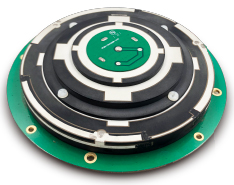
Harxon is showcasing high-precision positioning GNSS antennas and its latest wireless data transmission technologies for surveying applications at Intergeo, Oct. 16-18, in Frankfurt, Germany.
Image: Harxon
X-Survey is an 4-in-1 OEM antenna for both navigation and communication in the real-time kinematic (RTK) surveying applications. It provides standard Wi-Fi, Bluetooth, 4G, and multiple-constellation signal reception for GNSS positioning.
Its 3D design ensures a higher phase center stability and longer communication distance at a 360-degree direction, while lowering the impact of electromagnetic interference (EMI), hence increasing the overall machine efficiency and simplifying the RTK integration, the company said.
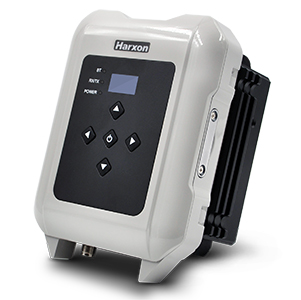
Photo: Harxon
The smart eRadio is a long-range and highly efficient radio modem designed to support RTK applications in surveying and precision agriculture. It can automatically identify RTK serial baud rate and provide a plug-and-play form for easy connection between eRadio and RTK.
According to Harxon, the eRadio’s diagnostic reporting software can configure data and update radio status, allowing users to effectively deal with potential issues. In addition, it is equipped with the unique ETALK communication protocol that increases the communication distance by 20 percent.
Other Harxon GNSS products showcased at Intergeo are for UAVs and precision agriculture, as well as surveying.
The D-Helix antenna HX-CHX600A is featured with its patented D-QHA technology.
Both 3D structured and mini-designed choke-ring antennas HX-CGX601A and HX-CGX611A can be used for base-station communication.
The multi-constellation survey antenna GPS 1000, frequency hopping modem HX-DU2017D and external radio modem HX-DU8608D are also popular products for high-precision performance.
Unicore Communications has launched CLAP-B, a multi-GNSS/MEMS integrated inertial navigation board, which integrates a miniaturized high-performance inertial measurement unit (IMU) on a compact high performance GNSS board.
The high-accuracy GNSS positioning coupled with a high-precision gyro and accelerometer provides stable, continuous three-dimensional position, velocity and attitude, as well as original acceleration and angular velocity measurements, even in GNSS-denied environments, the company said.
CLAP (Concurrent Localization & Attitude Pilot) technology is a high-precision multi-sensor fusion positioning and orientation technology developed by Unicore.
The CLAP- B, along with all the UM and UB family of receivers, are on display at BDStar booth C12.0C.022 for the duration of Intergeo 2018 starting Oct. 16 in Frankfurt, Germany.
Key features of the CLAP-B include:
Compact size: 46 × 71 × 17.1 mm
5-ns RMS PPS output
0.1 degree (1σ) pitch and roll
WINS optimized technology (wheel INS) for vehicles, wheeled robotics
With the features of compact size, light weight, low power consumption, and easy for integration and mass production, CLAP-B is suitable for applications such as autonomous driving, smart surveying, unmanned aerial vehicles and various attitude stabilization platforms. Customer samples will be available by the first quarter of 2019.
The GPS World staff is reporting from Intergeo Oct. 16-18 in Frankfurt, Germany. The massive trade show, dubbed the “global hub of the geospatial community,” brings together more than 17,000 visitors from more than 107 countries and features approximately 640 exhibitors. Check out the latest industry news, as well as photos and videos from the event.
Videos
Choose the video you’d like to watch by clicking the icon in the top left hand corner of the video screen.
Hexagon AB will showcase its portfolio of reality capture hardware and integrated software at Intergeo 2018, hall 12.1, booth D.023.
According to the company, it will also offer hands-on demonstrations for reality capture devices, airborne sensors and UAVs, measurement technology, cloud computing, artificial intelligence applications and more.
“Intergeo is a premiere event for showcasing Hexagon’s vision of enabling smart digital realities that ultimately create autonomous connected ecosystems for digital transformation,” said Ola Rollén, president and CEO of Hexagon. “The increasing role of autonomous technology is vital to enabling unaided decisions that draw and act on information from multiple sources simultaneously and become smarter over time. This is our focus and we are once again honored to share our ACE ideas and progress around smart cities, BIM, Geospatial 4.0 and other highly relevant topics to be discussed at the event.”
A number of Hexagon executives also will be speaking during the show, including Mladen Stojic, president of Hexagon’s Geospatial Division, who will be discuss the potential of 5D location intelligence; Maximilian Weber, senior vice president of Hexagon’s Safety and Infrastructure Division, who will discuss the potential of “the Internet of People” within a smart city; Juergen Mayer, laser scanning business director for Hexagon’s Geosystems Division, who will present the latest development in edge computing technology; Michael Dorman, global director at Multivista (part of Hexagon), who will look at how today’s construction leaders are reducing design, construction, marketing and operating expenses throughout a project’s lifecycle with digital solutions; Valentin Fuchs, UAV product manager, and Anne Pitkaenen, UAV marketing manager for Hexagon’s Geosystems Division, who will provide insights into the latest developments of the Leica Aibot.
NCTech, a developer of reality imaging systems, will showcase its iSTAR Pulsar mobile 360-degree data capture system at Intergeo in Frankfurt, Germany.
Companies at Intergeo, including GeoSLAM and Orbit Geospatial Technologies, will also unveil innovative developments that incorporate iSTAR Pulsar.
iSTAR Pulsar is NCTech’s professional edge-to-cloud big data system, optimized for capture on the move. iSTAR Pulsar is designed to capture 360-degree data while mounted on a vehicle, drone or on foot.
At Intergeo, NCTech will be showing a demonstration of a future feature in its cloud-based processing software VR.WORLD that uses artificial intelligence and image recognition to analyze the images captured by iSTAR Pulsar. This means that objects like cars, trucks, traffic lights, road signs, pedestrians and cyclists can be automatically identified in images, the company said.
Handheld 3D mobile mapping company GeoSLAM also will introduce new developments at Intergeo, including an innovation that integrates with iSTAR Pulsar.
“We immediately saw the potential for collaboration when NCTech introduced the iSTAR Pulsar,” said Mark Reid, head of strategic business development, GeoSLAM. “And now we’re excited to show the attendees at Intergeo what we’ve been working on.”
Orbit GT has updated its mobile mapping software to enable iSTAR Pulsar data to be integrated into its smart 3D mapping solutions.
“We’re very pleased to announce that Orbit GT solutions now support data from NCTech’s iSTAR Pulsar,” said Peter Bonne, CEO, Orbit GT. “We’ll be showcasing the great 360-degree imagery captured by iSTAR Pulsar at our booth.”
“We launched iSTAR Pulsar earlier this year, so it’s great to see that key industry players like GeoSLAM and Orbit GT are already leveraging its capabilities in their own developments,” said Andrew Baddeley, technical sales director, NCTech. “Combined with the exciting new AI developments from our labs, we look forward to showing everyone at Intergeo how we are helping to virtualize the world.”
NCTech, a developer of reality imaging systems, will showcase its iSTAR Pulsar mobile 360-degree data capture system at Intergeo in Frankfurt, Germany.
Companies at Intergeo, including GeoSLAM and Orbit Geospatial Technologies, will also unveil innovative developments that incorporate iSTAR Pulsar.
iSTAR Pulsar is NCTech’s professional edge-to-cloud big data system, optimized for capture on the move. iSTAR Pulsar is designed to capture 360-degree data while mounted on a vehicle, drone or on foot.
At Intergeo, NCTech will be showing a demonstration of a future feature in its cloud-based processing software VR.WORLD that uses artificial intelligence and image recognition to analyse the images captured by iSTAR Pulsar. This means that objects like cars, trucks, traffic lights, road signs, pedestrians and cyclists can be automatically identified in images, the company said.
Photo: NCTech
Handheld 3D mobile mapping company GeoSLAM also will introduce new developments at Intergeo, including an innovation that integrates with iSTAR Pulsar.
“We immediately saw the potential for collaboration when NCTech introduced the iSTAR Pulsar,” said Mark Reid, head of strategic business development, GeoSLAM. “And now we’re excited to show the attendees at Intergeo what we’ve been working on.”
Orbit GT has updated its mobile mapping software to enable iSTAR Pulsar data to be integrated into its smart 3D mapping solutions.
“We’re very pleased to announce that Orbit GT solutions now support data from NCTech’s iSTAR Pulsar,” said Peter Bonne, CEO, Orbit GT. “We’ll be showcasing the great 360-degree imagery captured by iSTAR Pulsar at our booth.”
“We launched iSTAR Pulsar earlier this year, so it’s great to see that key industry players like GeoSLAM and Orbit GT are already leveraging its capabilities in their own developments,” said Andrew Baddeley, technical sales director, NCTech. “Combined with the exciting new AI developments from our labs, we look forward to showing everyone at Intergeo how we are helping to virtualize the world.”
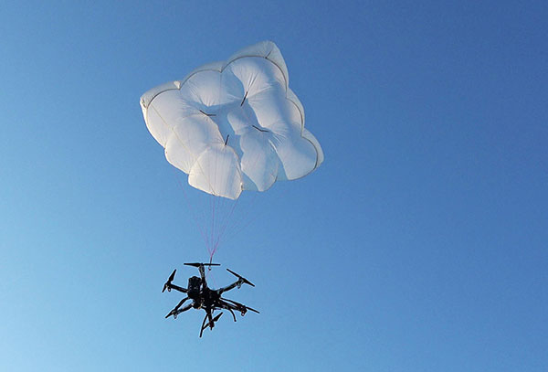
Drone Rescue will present its parachute systems DRS-5 and DRS-10 to the professional public for the first time at Intergeo, at stand 12.0B.112 in Hall 12, Oct. 16-18.
Parachute rescue system DRS-5 is designed for multicopters with a total weight of up to 8 kg. The system consists of a carbon cage in which the parachute is stored, as well as the associated electronics.
The electronics, including the sensors, monitor the flight status of a drone independent of the flight controller. A sophisticated algorithm merges this sensor data, through which an automatic crash detection can be realized, the company said. In an emergency, the pilot no longer needs to react and press an eject button. (Often, this is technically no longer possible anyway, such as with a failure of the radio link.)
Furthermore, the algorithm reacts faster than the pilot: the system ejects the parachute itself. All flight data and movements are recorded in a black box. In an emergency, these can be read out at the request of the customer and made available to insurance companies or authorities.
“Our goal is to ensure that even in an emergency beyond visual line of sight the drone can be safely intercepted. With our parachute system, that is always possible, due to the electronics that are completely separate and independent of the flight controller,” said Andreas Ploier, CEO and co-founder of Drone Rescue. “In addition, our system has the advantage that it manages completely without explosive, pyrotechnical solutions. Consequently we have a system that is considerably lighter, and functions even in a worst-case scenario.”
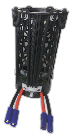
DRS10 system. (Photo: Drone Rescue)
The reliability of the system has been verified in extensive tests by Joanneum Aeronautics in Graz, Austria. In the framework of the tests, 100 flights were conducted during which the parachute system was ejected.
Half of the flights were conducted with a DJI F550 weighing 1.6 kg. The rest of the tests were performed with the 3.8 kg Vulture, which was developed by the FH Joanneum.
In both cases, the DRS-5 was attached to the side of the main body of the drone. In each of the tests the parachute was ejected at a height of 30 meters. Every test was documented.
Furthermore, the data were saved both in the flight controller as well as in the DRS-5 sensor system. After every 10th test, the parachute system was subjected to a visual examination and checked for possible damage or wear.
“After conclusion of the tests, it can be recorded that all 100 flights were successfully completed,” Ploier said. “In every test the multicopter landed safely. Thereby, the kinetic energy was significantly below the limit of 79 J. All requirements specified by the European Aviation Safety Agency (EASA) were observed.”
Besides the DRS-5, the structurally identical parachute system DRS-10, which is designed for multicopters with a total weight between 5 and 20 kg, will also be presented at Intergeo 2018. “The DRS-10 system functions exactly the same as the DRS-5 and falls back on the same components. These are constructed identically, just oriented for a higher payload. The functioning method of both parachute systems is identical,” Ploier said.
With flight tests for the DRS-5 completed in late summer, the first systems will be delivered to end customers in winter 2018.
The theme for this year’s Intergeo, taking place Oct. 16-18 in Frankfurt, Germany, is “Geoinformation — The DNA of digitalization.”
According to event organizers, this year’s event will focus on the digital transformation of business and society. The event, hosted by the German Society for Geodesy, Geoinformation and Land Management (DVW), will contextualize key developments and scenarios for a geoinformation-based digital future.
“Over the course of three days, the spotlight will be placed on the products, solutions, know-how, innovations and visions behind geoinformation in the era of digitalization,” said Professor Hansjörg Kutterer, president of DVW. “And we confidently label geoinformation the DNA of digitalization. After all, in the same way as humans are shaped by their genes, geoinformation is steering the digital revolution.”
Intergeo 2018 will feature 130 speakers, with each day of the show beginning with keynote speeches. Among the keynote speakers are Kutterer; Professor Jürgen Döldner from the Hasso Plattner Institute in Potsdam, Germany; and Ron Bisio from Trimble.
In addition, more than 600 companies will be exhibiting at the show.