Septentrio’s Gustavo Lopez gives GPS World an overview of the company’s AsteRx-i S UAS GNSS/INS receiver for drones and Mosaic GNSS receiver module at Intergeo 2019, which took place Sept. 17-19 in Stuttgart, Germany.
Hexagon showcased the Leica DSX utility detection solution at Intergeo 2019. (Photo: Allison Barwacz)
Hexagon AB presented its Smart Buildings & Infrastructure and Smart Cities & Nations portfolios at Intergeo 2019, which took place Sept. 17-19 in Stuttgart, Germany.
At the show, the company exhibited a number of its solutions designed to help manage the life of a building — from initial land surveying, through design, build, maintenance, renovation and demolition — and optimize the completion of infrastructure projects. These solutions include the Leica DSX utility detection solution, the BricsCAD building design software and HxGN SmartBuild.
Reality capture solutions showcased at Intergeo 2019 include Hexagon’s Leica BLK2GO mobile reality capture solution, the HxGN Content Program, and the Hexagon Smart M.Apps and Luciad portfolios.
“The ultimate form of data leverage is when tasks and processes become autonomous, which is the goal of our smart solutions portfolios,” said Ola Rollén, president and CEO at Hexagon. “We help customers leverage the data within their workflows to achieve the greatest efficiency, productivity and quality outcomes possible. When we collectively achieve these outcomes at scale, not only can we sustain growth for our businesses, but also this finite planet we all share…fewer resources, less waste, less pollution.”
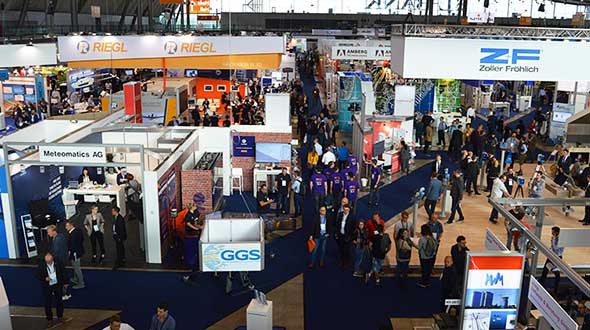
The GPS World staff reported live from Intergeo Sept. 17-19 in Stuttgart, Germany. The massive trade show, dubbed the “global hub of the geospatial community,” brings together more than 19,000 visitors from more than 114 countries and features approximately 640 exhibitors. Check out the latest industry news, as well as photos and videos from the event.
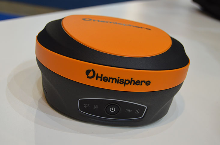
Hemisphere GNSS has introduced its multi-frequency, multi-GNSS S621 GNSS survey smart antenna and R620 GNSS receiver at Intergeo 2019 in Stuttgart, Germany, and ION GNSS+ 2019 in Miami.
S621 GNSS survey smart antenna
The S621 GNSS survey smart antenna is a complete redesign of Hemisphere’s previous generation version, the S321+. (Photo: Allison Barwacz)
The S621, powered by the company’s Phantom 40 GNSS OEM board, is a complete redesign of Hemisphere’s previous generation version, the S321+.
According to the company, the S621 processes and supports more than 800 channels with flexible and scalable simultaneous tracking of every modern and planned GNSS constellation and signal including GPS, GLONASS, BeiDou (including Phase 3), Galileo, QZSS, IRNSS, SBAS and Atlas L-band.
The S621 combines Hemisphere’s Athena GNSS engine and Atlas L-band correction technologies with a new WebUI. It meets IP67 requirements and is immune to magnetic interference. It is designed for use in land or marine survey, GIS, mapping, construction or other applications requiring high-performance precision and positioning, the company added.
“The S621 represents the advanced technology, durability, and ease-of-use that our customers have come to expect,” said Miles Ware, director of marketing at Hemisphere. “By redesigning this system from the ground up with increased functionality and management capabilities, we are offering unbeatable value.”
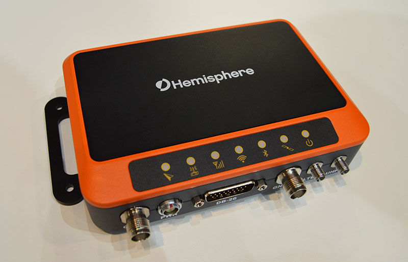
R620 GNSS receiver
The R620 GNSS receiver is a complete refresh of Hemisphere’s previous version, the R330. (Photo: Allison Barwacz)
The R620 GNSS receiver, powered by the Vega series, is a complete refresh of Hemisphere’s previous version, the R330, and includes an all-new low-profile ruggedized enclosure.
According to Hemisphere GNSS, the R620 GNSS receiver processes and supports more than 1,100 channels and offers flexible and scalable simultaneous tracking of every modern and planned GNSS constellation and signal including GPS, GLONASS, BeiDou (including Phase 3), Galileo, QZSS, IRNSS, SBAS and Atlas L-band.
The R620 combines Hemisphere’s Athena GNSS engine and Atlas L-band correction technologies with status LEDs and a WebUI. It also comes equipped with UHF (400 MHz and 900 MHz) radio, cellular modem, Bluetooth and Wi-Fi.
“With its all-new design and feature set, the R620 GNSS receiver is Hemisphere’s offering to what the market desires — smaller machine, lower cost and less power,” Ware said. “The receiver boasts a feature- and performance-packed combination of greater performance, improved robustness and excellent value.”
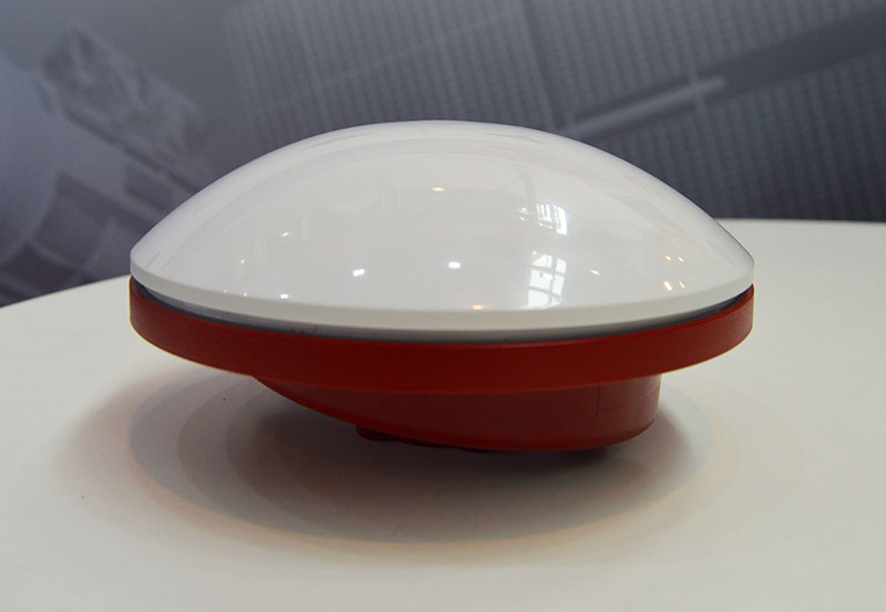
The VSP600L VeroStar supports the full GNSS spectrum, as well as L-band correction services. (Photo: Allison Barwacz)
Tallysman has released its VSP600L VeroStar precision antenna at Intergeo 2019, which took place Sept. 17-19 in Stuttgart, Germany.
The VeroStar supports the full GNSS spectrum, as well as L-band correction services. The antenna provides low elevation satellite tracking with a high efficiency radiating element, the company said.
Its performance is suitable for real-time kinematic (RTK) and precise point positioning (PPP) applications. It features a light, compact and robust design. The antenna also has a low axial ratio through all elevation angles providing strong multipath rejection.
According to Tallysman, the VSP600L VeroStar also provides high receive gain over the full GNSS spectrum from low GNSS band (1164MHz to 1300MHz) L-band correction services (1539MHz to 1559MHz) to high GNSS band (1559MHz to 1610 MHz).
The antenna also has a low axial ratio through all elevation angles providing strong multipath rejection.
“The most unique feature of the VeroStar antenna is the high gain at low elevations,” Allen Crawford, director of key accounts at Tallysman, told GPS World at the show. “It can track low elevation satellites with a really high signal level, which is really important for those using correction services coming off of geostationary satellites. So as you go further away from the equator, you’re dealing with some very small link margins and you need those extra up to 4dB higher signal strength that this antenna provides.”
According to the company, it will soon be releasing embedded models of the VSP600L VeroStar.
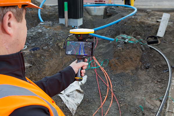
Trimble has introduced its Trimble SiteVision system, an outdoor augmented reality (AR) solution that enables users to visualize 2D and 3D data on virtually any project site with cellular or internet connectivity for easier and more efficient planning, collaboration and reporting.
Combining hardware and software in an integrated, lightweight handheld or pole-mounted solution, users can view 3D models and assets in a real-world environment at a 1:1 scale, from any angle or position.
The system consists of:
Hardware: The Trimble SiteVision integrated positioning system integrates the Trimble Catalyst DA1 antenna, electronic distance measurement (EDM) rangefinder and power management into a lightweight, handheld device that connects to a user-supplied Android mobile phone.
Software Subscription: Available to single users on a monthly or yearly basis. The SiteVision software subscription combines Trimble’s high-accuracy positioning services and cloud-based processing technology to create a centimeter-accurate AR system. The system leverages Trimble cloud-based processing to manage and deliver data and design models.
SiteVision enables users to visualize digital models from a wide range of data collection, design and constructible modeling tools in open industry-standard formats including IFC and LandXML.
For civil projects, SiteVision accurately visualizes data from Trimble’s Quantm, Business Center and Novapoint; design data from Civil 3D and Bentley OpenRoads; and GIS data from Esri ArcGIS software.
Photo: Trimble
SiteVision powers building information modeling (BIM) projects with open data from Trimble’s Constructible BIM solutions including SketchUp and Tekla, and BIM data from Autodesk Revit and AutoCAD software. For utility companies, PLS-CADD power line design, Distribution Design Studio (DDS) and other industry-specific design data is also supported.
Using Trimble Connect cloud-based hosting, SiteVision can access models from all stages of the lifecycle of infrastructure and buildings—from initial concepts of roads or buildings through the operations and maintenance phase of the assets—to increase collaboration, enhance work accuracy and ultimately improve operations and utilization.
SiteVision simplifies complex concepts by allowing users to blend digital content with real-world environments. For example, city planners can visualize a new building design in the exact spot it is to be erected, a work crew could identify the exact position of underground cables or pipes before digging, an electric utility can confirm placement of poles and lines with customers and crews, or a construction supervisor could assess the progress of heavy equipment by visualizing actual work performed against the site plan.
“It’s easier to understand complex ideas when we can see them in a real-world context,” said Mark Nichols, general manager at Trimble. “SiteVision improves our understanding of projects and worksites with a handheld device that is accessible to a wide range of users. Augmented reality is now ready for everyday use in a wide range of applications.”
Trimble SiteVision is available to order now through Trimble’s authorized distribution channels for Civil Engineering and Construction, Geospatial and Buildings.
The Bluesky MetroVista range includes high-resolution imagery combined with high-accuracy, wide-scale 3D models. (Image: Bluesky)
Bluesky International has launched its international MetroVista city mapping service for Europe at Intergeo 2019, which took place Sept. 17-19 in Stuttgart, Germany.
The mapping service incorporates the Leica CityMapper hybrid airborne sensor, which can simultaneously capture vertical and oblique aerial photography, as well as lidar.
According to the company, the Bluesky MetroVista range includes high-resolution imagery combined with high-accuracy, wide-scale 3D models. Bluesky’s CityMapper also has already been used to capture MetroVista data for cities across the United Kingdom, including London, Manchester, Newcastle and Bristol.
Bluesky’s CityMapper, used to produce the MetroVista data, includes a traditional vertical camera, as well as survey-grade oblique cameras. The sensor, designed for 3D city modeling and urban mapping, incorporates lidar technology to accurately collect elevation and infrared data.
“Here at Intergeo, we’re showing our MetroVista data sets, which are the city meshes,” Ralph Coleman, sales director at Bluesky, told GPS World. The city meshes are extremely dense, they’re very feature-rich, and they’re vey accurate. They provide a vast range of detail for a massive range of applications.”
Bluesky is a United Kingdom-based aerial survey and geographic data company that produces and maintains digital aerial photography and height data. The company has offices in the United Kingdom, United States and the Republic of Ireland, as well as a production center in India.
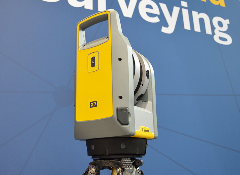
The Trimble X7 is designed for surveying, construction, industrial and forensic applications. (Photo: Allison Barwacz)
Trimble has released its X7 3D laser scanning system at Intergeo 2019, which took place Sept. 17-19 in Stuttgart, Germany. According to the company, the system is designed to enable professionals of all scanning levels to quickly and easily capture precise 3D scanning data to produce high-quality deliverables.
The X7 is designed for surveying, construction, industrial and forensic applications. The scanner features Trimble X-Drive technology, survey-grade self-leveling and a smart calibration system.
“We are really excited to bring the X7 to the market,” Gregory Lepere, marketing director, optical and imaging, Trimble, told GPS World. “It’s a very simple solution but offers a lot of smart technology. Every time you turn the instrument on, the automatic calibration will start, so you’re guaranteed to have all of the specifications all of the time.”
It also integrates streamlined workflows to provide automatic registration of point cloud data in the field with Trimble Registration Assist.
“The feature bringing the most simplicity to the solution is the Trimble Registration Assist technology, which is a full registration in the field, bringing all of the scans together thanks to self-leveling IMU technologies combined with cloud-based software,” Lepere said.
Survey applications
For surveyors and geospatial professionals, the X7 provides fast and balanced performance in both indoor and outdoor environments and is ideal for industrial survey/tank calibration, civil infrastructure, general surveys, road intersection surveys, utilities, mining, and historical documentation and renovation, Trimble said.
The X7 is fully integrated with the Trimble Perspective software, which enables scans and images to be captured, fully registered together, refined, controlled and exported to a variety of established data format for Trimble and non-Trimble software suites.
Building design and construction applications
For users in building design and construction, the X7 assists with measurement problems and improves field productivity for a broad range of applications in architecture, engineering and construction industry projects.
For these applications, the X7 is fully integrated with Trimble Field Link software to provide streamlined workflows specific to the building construction industry — from scanning to modeling to field layout.
Forensics applications
According to Trimble, the X7 can perform in demanding conditions and offers easy setup for investigators and law enforcement. It also pairs with the company’s Trimble Forensics Capture software.
The Trimble X7 is expected to be available in the first quarter of 2020.
Tersus GNSS President and CEO Xiaohua Wen gives GPS World an overview of the company’s Oscar GNSS receiver at Intergeo 2019 in Stuttgart, Germany. According to the company, the Oscar GNSS receiver offers calibration-free tilt compensation that is immune to magnetic disturbances.
Topcon Positioning Group displayed its GTL-1000 scanner at Intergeo 2019, which took place Sept. 17-19 in Stuttgart, Germany. According to the company, the GTL-1000 is a compact scanner integrated with a fully featured robotic total station, enabling a site engineer to complete a layout and scan on a single setup.