The International GNSS Real-Time Service
By Mark Caissy, Loukis Agrotis, Georg Weber, Manuel Hernandez-Pajares, and Urs Hugentobler
The International GNSS Service has embarked on a project to provide a high-accuracy GPS satellite orbit and clock data service in real time. The service will also provide 1-Hz data streams of GPS and GLONASS data from a network of global continuously operating reference stations. The IGS real-time data and orbit and clock products will be of immense benefit for geoscience studies and a host of other science and engineering applications. A team of authors associated with this project discusses the genesis and status of the real-time service and the plans to provide an initial operating capability.

GPS HAS ALWAYS BEEN A REAL-TIME POSITIONING SYSTEM. From the outset, GPS was designed to provide virtually instantaneous position, velocity, and time, anywhere in the world, 24 hours per day. Its real-time positioning capability is achieved, in part, by measuring pseudoranges on multiple satellites simultaneously and by using the satellite orbit and clock data transmitted by the satellites themselves. The one-sigma accuracy of the horizontal component of the real-time positions obtained from measurements on the L1 frequency only, in a low multipath environment, can be as good as a meter. The accuracy is limited by the resolution and noise of the pseudorange measurements and the accuracy of the transmitted satellite orbit and clock data and the L1 ionospheric delay model.
Much higher position accuracies are routinely achieved by using dual-frequency carrier-phase observations and precise satellite orbit and clock data computed from measurements provided by global tracking networks. Ionosphere corrections are also available for single-frequency users. The International GNSS Service (IGS) has been at the forefront of providing such data since its inception in 1994. The IGS now consists of over 200 actively contributing organizations in more than 80 countries and a global network of over 370 active stations. In addition to providing high-accuracy GPS satellite orbit and clock data, the IGS provides similar GLONASS products as well as GPS and GLONASS raw measurements and related information.
Traditionally, the IGS data and products have been delivered with some delay with the intention that they be primarily used for so-called post-processing of user-collected data. For example, the “Final” GPS satellite orbit and clock products, the ones with highest accuracy, are delivered with a latency of 12–18 days. And while half of the “ultra-rapid” product is available for real-time use, the data is predicted based on earlier observations and has considerably less accuracy than the other IGS products. Recently, the IGS embarked on a project to provide a high-accuracy GPS satellite orbit and clock data service in real time. The service will initially also provide 1-Hz data streams of GPS and GLONASS data from a network of global continuously operating reference stations. Data and products from the Galileo and Compass systems will be added later. The IGS real-time data and orbit and clock products will be of immense benefit for geoscience studies and a host of other science and engineering applications.
In this month’s column, a team of authors associated with this project discusses the genesis and status of the real-time service and the plans to imminently provide an initial operating capability.
“Innovation” features discussions about advances in GPS technology, its applications, and the fundamentals of GPS positioning. The column is coordinated by Richard Langley, Department of Geodesy and Geomatics Engineering, University of New Brunswick.
For more than a decade, the International GNSS Service (IGS) has been developing real-time infrastructure and processes and is now in the final stages of preparation for the launch of the IGS Real-Time Service (IGS-RTS) in the second half of 2012. The exact launch date will be decided at an IGS workshop in July. The service will begin with a status of initial operating capability (IOC) and will provide access to continuous streams of one-hertz GNSS data from a global network of stations in real time. It will also give access to globally valid wide-area GPS orbit and clock corrections, which will be capable of supporting sub-decimeter real-time precise point positioning (RTPPP).
The availability of data and products from this new service will follow the IGS’s open data policy that these products will be openly available to all. Owing to the nature of this international collaboration, the IGS-RTS will be offered without a service guarantee. Data and products will be generated on a “best effort” basis; however, the service will have considerable redundancy built in and is likely to achieve the same degree of reliability for which other IGS services are known. When launched, the new service will contribute to the IGS goal of integrating new systems, technologies, and applications into IGS products and services so as to meet the changing needs of its user community.
The IGS is an operational scientific service of the International Association of Geodesy and one of several services contributing to the Global Geodetic Observing System (GGOS). Data and products generated by the RTS will contribute to the natural hazards theme within GGOS. The RTS will support applications that detect, in real time, motions that are precursors to natural hazards such as landslides, volcanic activity, and tsunamis. To assist in fulfilling their own mandates, national geodetic and space agencies have contributed to the development of the real-time service and will continue to be involved both as contributors and users of the IGS real-time products. Other applications for the service will include GNSS constellation performance monitoring, weather forecasting, and space weather monitoring. For further background on the impact that real-time geodesy is having on the scientific community and applications, refer to the Eos article listed in the Further Reading sidebar. The online version of this article provides additional information in answer to the question “Why is the IGS involved in real-time GNSS?” (see also Further Reading).
In this article, we discuss the following topics:
- The open standards that have been adopted by the IGS for the delivery of real-time GNSS data, orbit, and clock corrections;
- The IGS real-time infrastructure that is in place to ensure a reliable service;
- The generation, organization, and performance of the real-time clock and orbit products;
- A global real-time vertical total electron content (RT-VTEC) product under development;
- User access and tools;
- Future plans.
Historical Look at Real Time
The development of the RTS has followed the traditional stages of development for a new IGS service. First, a working group is formed and tasked with meeting certain goals. Second, a pilot project is initiated and, if successful, is followed by the third and final stage, which is the launch of the new service.
The IGS Real-Time Working Group (RTWG) was established in 2001 with the goal of designing and implementing real-time infrastructure and processes for the delivery of real-time data to analysis centers, and the dissemination of real-time products to users. The working group’s direction was set at the IGS workshop, “Towards Real Time” held in Ottawa in the spring of 2002. At that time, the design for a prototype real-time service was adopted.
In June 2007, the IGS announced the Call for Participation in the IGS Real-time Pilot Project with a three-year target to accomplish its goals. In 2009, the pilot project was extended to March 2011, and in August 2011 the working group declared that the pilot project had reached the additional goal of IOC and that it would be recommending to the IGS governing board the launch of an official real-time service.
Open Standards Adopted
An important objective of the IGS is to develop and maintain standards and formats for GNSS data and products. To achieve this objective for real-time GNSS, the IGS joined the Radio Technical Commission for Maritime Services Special Committee 104 (RTCM-SC104) in 2008. After joining RTCM, the IGS real-time project adopted the RTCM-3 format for GPS and GLONASS observation messages and the RTCM-State Space Representation (RTCM-SSR) format for orbit and clock correction messages.
The Receiver Independent Exchange (RINEX) archival format became the shared responsibility of both the IGS and RTCM-SC104 in spring 2011. Because of this new development, there is now a project underway to develop binary messages that will enable the creation of a complete RINEX file from RTCM-SC104 binary messages. Part of this project involves the development of a new message format for GNSS data called RTCM-Multiple Signal Messages (RTCM-MSM). To enable interoperability among different GNSS receiver types, all phase observations in RTCM-MSM messages are aligned to the frequency band’s reference signal. An amendment to support the QZSS and Compass constellations is planned as the next step in the evolution of this format.
IGS-RTS GNSS orbit and clock corrections are distributed using RTCM-SSR messages. These messages were designed to enable RTPPP and were officially adopted as an RTCM standard in May 2011. The format supports both GPS and GLONASS constellations. The combined resolution of the RTCM-SSR corrections supports millimeter-accuracy corrections and positioning at the same level. Enhancements to support Galileo, QZSS, and Compass constellations, and a global ionosphere correction format are planned.
Delivery via NTRIP
The IGS-RTS uses the Network Transport of RTCM by Internet Protocol (NTRIP) for internal operations and for the delivery of real-time products to its user community. NTRIP became an RTCM standard in 2004 and since that time has developed into a series of components that collectively provide a robust and proven system for the collection and distribution of GNSS information in real time. Being an RTCM standard, NTRIP is the ideal protocol for delivering and receiving HP-MSM and SSR messages. More information on NTRIP can be found in Further Reading.
Infrastructure Design
Owing to the collaborative and best-effort nature of the contributions that collectively comprise each of its services, the IGS cannot make any commitments or guarantees for the accuracy or availability of the RTS. However, the IGS understands that its user community expects the service to be reliable, both in terms of accuracy and availability.
To meet accuracy expectations, the IGS will strive to remain on the cutting edge of global real-time positioning and associated technologies as they evolve. To meet its user community’s expectations for availability of the service, the IGS will work to ensure there is a reliable flow of GNSS data and products from the source through the production chain, in real time without interruption. To accomplish this, redundancy has been provided for the paths across which data and products will flow, thus reducing the likelihood of total failure in the network.
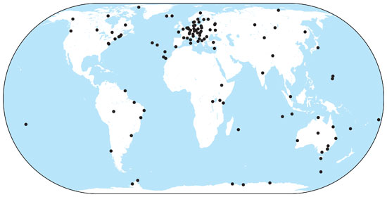
Figure 1 illustrates the distribution of real-time tracking stations in the network. The network is currently made up of approximately 130 globally distributed stations maintained by a wide variety of local and regional operators. These stations deliver one-hertz data to the real-time data centers with typical latencies of 3 seconds or less.
Global coverage is essential for the success of the service, and the presence of redundant stations in geographical regions enhances the reliability of data available from these regions. This goal has been a challenge in some areas of the globe — for example, the south Pacific.
IGS station operators are required to adhere to a minimum set of standards and are encouraged to adopt best practices for real-time operations.
Examples of best practices are:
- Real-time data should be transmitted to a minimum of two separate real-time data centers;
- Stations that contribute to the realization of the IGS reference frame should be operated in real time to guarantee a reliable alignment of the real-time products to a stable reference frame.
Real-time analysis centers (RTACs) are also encouraged to adopt the best practice of building the ability to ingest data from two or more global data centers into their processing strategy.
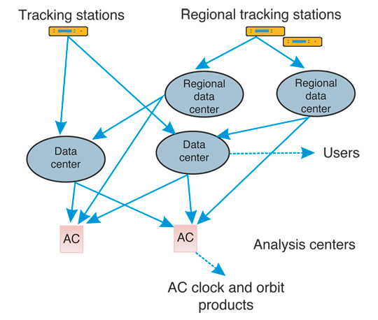
Figure 2 illustrates the single tracking station and a regional network architecture. This arrangement specifies that data streams from the tracking stations should be sent to two separate real-time data centers where they become available to users. In this architecture, analysis centers can source reference station data from more than one data center. This design reduces the likelihood of single points of failure, making the data network more robust.
Once the GNSS data are successfully delivered to the analysis centers, they are processed, the generated products are sent to combination centers, and the final product streams are distributed to users.
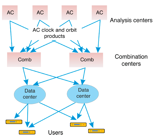
Figure 3 illustrates the analysis-center to combination-center to user-network architecture. As with the classical orbit and clock products, the reliability of real-time products will be assured through the creation of a combined product that is based on submissions from a minimum of three RTACs. Analysis centers are encouraged to adopt the best practice of sending generated product streams to two independent combination centers. To ensure the availability of products, users will have redundant data centers from which to choose real-time products.
RTAC Design and Results
As part of the Real-Time Pilot Project (RTPP), 11 RTACs generate real-time orbit and clock correction products: the Federal Agency for Cartography and Geodesy (BKG); the Centre National d’Etudes Spatiales (CNES); the Czech Technical University (CTU); the German Aerospace Center (DLR); the European Space Operations Centre (ESOC); GEO++; the German Research Centre for Geosciences (GFZ); Natural Resources Canada (NRCan); GMV; the Vienna University of Technology (TUW); and Wuhan University (WUH).
The design of the RTS specifies that GNSS orbit and clock corrections are to be delivered every 5 seconds. Typically RTACs wait 5 seconds for station data to be collected. Allowing 5 seconds for data processing and correction distribution yields a delay of 10 seconds once the RTAC products reach the combination center.
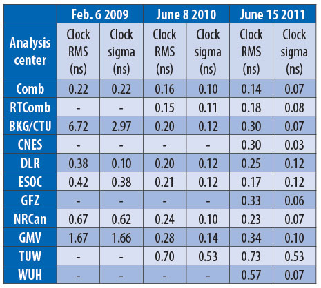
The role of the real-time analysis center coordinator (RTACC), currently performed by ESOC, is to coordinate the activities of the RTACs and to generate and assess the quality of the combined real-time clock product. Table 1 shows snapshots of the performance of RTAC and combined products in the RTPP since 2009. The quality of the individual RTACs and the combined products is assessed through the root-mean-square (RMS) and standard deviation (sigma) of the difference between the individual products and the IGS rapid clock product. It is interesting to note the increase in participation as well as the improvement in the results over time. The target for the pilot project was to produce a combined clock product accurate to within 0.3 nanoseconds when compared to IGS rapid products. This was achieved early on in the project. The June 15, 2011, results shown are consistent with today’s results.
RTAC Coordinator Methods, Results
The RTACs generate their orbit and clock estimates every 5 seconds and transmit them to the combination centers where they are processed using combination software. The latency of the combination process is 5 seconds, which, when added to the delay of products arriving from the individual RTACs, yields a total combination delay of approximately 15 seconds.
The RTACC combination method detects and removes outliers that may be present in individual solutions. The combination is generated by first aligning all the solutions to a reference solution by removing a common solution-specific offset from all the satellite clocks. After alignment, clock differences between pairs of solutions are processed for outlier detection and for generation of a combination product. Satellite orbits are combined using solution averages after outlier detection.
Satellite orbit corrections are estimated for two reference points, the satellite center of mass (CoM) and the satellite antenna phase center (APC). The orbit and clock correction products for both CoM and APC are encoded into RTCM-SSR streams. These streams are then transmitted to two or more data centers, where they become available to users or to other data centers. Additional information that will assist the user in selecting between CoM or APC streams will be available once the service is launched. Currently, only satellite orbit corrections referenced to APC are supported by the RTCM-SSR standard. To avoid confusion, the CoM streams will have restricted access when the IOC service is launched. The IGS will be tabling amendments to the RTCM standard in order to allow both reference points to be transmitted without restrictions.
Table 2 shows combined product streams operating within the RTPP. Both a single-epoch combination product developed by ESOC and a Kalman-filter combined product developed collaboratively by BKG and CTU are available. A GPS-plus-GLONASS Kalman-filter combined product has also been developed at BKG and CTU.
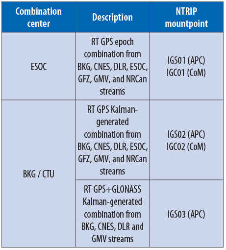
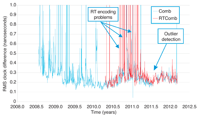
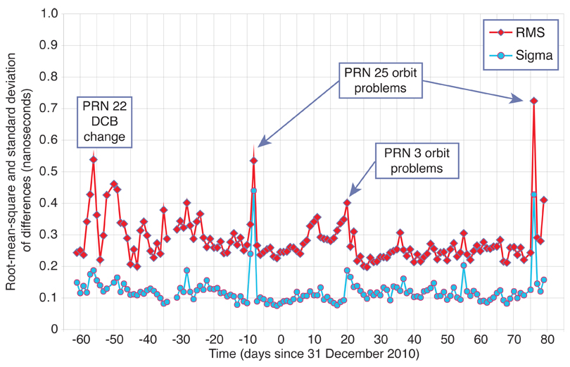
Figure 4 shows the history of the clock RMS performance of the single-epoch combination solution against the IGS “rapids.” This was the first combination product generated by the RTPP, and it started as a batch combination from daily orbit and clock file submissions by the RTACs. From early in 2010, ESOC started providing the first real-time combination product, generated directly by processing the real-time correction streams. The batch combination is in blue, while the real-time combination, starting in 2010, is in red. After an initial improvement phase, the results are stable except for occasional outliers. The outliers are due to problems in the individual solutions, and these should be removed by a properly executed combination methodology. Outliers in the combination towards the end of 2010 and beginning of 2011 were caused by RTCM encoding errors in some RTAC streams. Improvements to the outlier detection algorithm were introduced in early 2011, and it can be seen that the incidence of results with high RMS have been drastically reduced. Most outliers are now caused by poor orbit results after satellite maneuvers. Figure 5 illustrates the effectiveness of the outlier-detection algorithm.
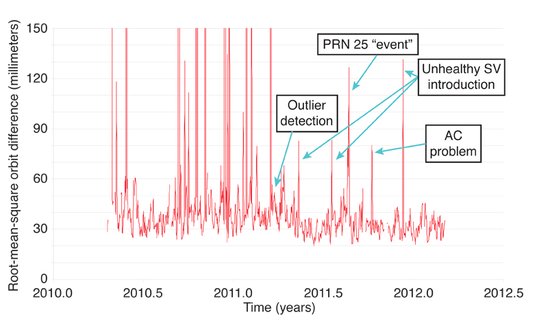
The RTAC orbit solutions use the predicted portion of an orbit arc. Most RTACs use the IGS Ultra Rapid Orbit product, but some use their own batch solutions, refreshed every one to two hours. The orbit results of the combined orbit product exhibit patterns similar to the clock results, with a significant improvement after outlier detection was introduced. The main problems are highlighted in Figure 6. There were some instances of what appear to be unannounced thrusting events on GPS satellite PRN 25. At times, problems arose from the re-introduction of previously unhealthy satellites. Other sources of error are occasional problems in one of the AC solutions, which are not entirely removed by the outlier detection algorithm.
The performance of the real-time combination products is monitored mainly through daily comparisons against the IGS rapid products as per the examples shown in Table 1. The products are also monitored through continuous kinematic precise point positioning (PPP) on the BKG NTRIP website. Sample combination stream PPP results are shown in Figure 7, where it can be seen that the horizontal error component is for the most part less than 10 centimeters and the vertical component is approximately a factor of two higher.
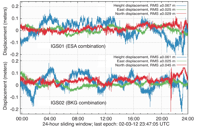
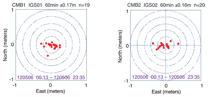
Figure 8 illustrates the results of daily PPP convergence test conducted on the two GPS-only combination products. These are performed at 23 globally distributed sites during successive hours of the day. The results illustrated are the horizontal RMS errors for the last 10 minutes of each test, after an allowed convergence time of 50 minutes.
Development of a RT-VTEC Product
Within the IGS, associate analysis centers (ACC) produce specialized or derived products. Two examples of real-time ACCs are the Universitat Politècnica de Catalunya (UPC) and DLR. They have participated in the IGS RTPP and continue to collaborate on the development of a combined global IGS RT-VTEC product. This collaboration is occurring under the umbrella of the IGS Ionosphere Working Group led by the University of Warmia and Mazury in Olsztyn, Poland, the host for this summer’s IGS workshop.
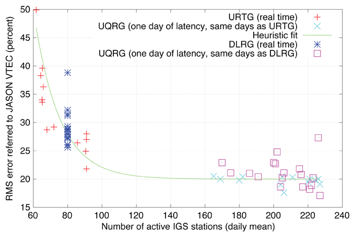
Figure 9 illustrates a comparison between preliminary global RT-VTEC products from UPC and DLR. This plot shows the RMS difference between each center’s product and Jason satellite altimeter VTEC measurements, taken over the ocean, versus the daily average number of active real-time GNSS receivers selected from the global real-time tracking network. A constant number of 80 stations was chosen for the DLR comparisons. As a control for the comparisons, UPC’s rapid product (UQRG) was also used. The Jason comparisons are considered pessimistic for the overall global VTEC product accuracy because the land-based tracking stations are generally located quite far from the location of the Jason measurements. The importance of a reliable globally distributed and sufficiently dense real-time GNSS tracking network is evident. These results suggest that it may be feasible to combine real-time VTEC products from several centers into a robust IGS real-time ionosphere product.
Work to compare both solutions is underway with the goal of finding optimal ways to assess and combine these products into an IGS RT-VTEC product. Future efforts will include working with RTCM to ensure that the IGS RT-VTEC product is compatible with ionosphere-correction information proposed for the RTCM-SSR standard.
Products, User Access, and Tools
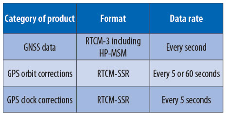
Table 3 presents a list of products by category that will be offered by the service when it is launched. The list of products within each category will be finalized following the workshop in July. Once the final list of products is decided on, a user’s guide will be developed that will provide a detailed description of the products, their use, and where they can be accessed.
It was mentioned earlier that the IGS-RTS uses the NTRIP protocol for the delivery of products to users. Users must use an NTRIP client application, either standalone or embedded in the user equipment, to establish a communication link with the data center that hosts the products of interest. Fortunately, open source software is available for this purpose: The BKG NTRIP Client (BNC) and the RTKLIB software (developed by T. Takasu) may be used. Both are open source applications and both support a variety of GNSS positioning applications. Links to these software packages are provided in Further Reading.
Future Direction
The real-time tracking network will continue to grow, and new receivers that can track all available GNSS constellation signals will be added. The IGS Multi-GNSS Experiment (M-GEX) will help improve the tracking network and associated data collection, quality control, and analysis procedures. Currently, several RTACs produce GLONASS orbits and clock corrections. Most RTACs are working to support the GLONASS and Galileo constellations, with QZSS and Compass on the horizon. The RTACC will continue to improve the combination process and reduce correction latency. The availability of real-time data streams and corrections from several constellations will challenge the IGS and GNSS community to develop new and innovative applications that take advantage of all available GNSS observations and receiver hardware.
Conclusion
The IGS is now in the final stages of preparation for the launch of its Real-Time Service. As with other IGS services, the RTS will be offered without a service guarantee. From the initial formation of the RTWG in 2001, through the pilot project stage, to today’s state of readiness, the development of the service has benefited from collaboration among many member organizations, most notably the real-time analysis centers.
Given its use of international standards, a built-in level of redundancy, and combined-products design, the IGS Real-Time Service will support robust high quality sub-decimeter real-time positioning on a global scale.
Acknowledgments
The authors wish to acknowledge the important contributions of the more than 30 agencies that participated in the IGS real-time pilot project. Most notably, the station operators and real-time analysis centers that we rely on to deliver, day in and day out, high quality data and products, and without whom the service would not be successful. The authors also wish to acknowledge the work of GEO++ in leading the development of the RTCM-SSR correction format.
Why Is IGS Involved in Real-Time GNSS?
Since its inception in 1994, the IGS has produced high-quality GNSS data products from a cooperative global infrastructure. The IGS products enable access to the definitive global reference frame for scientific, educational, and commercial applications that greatly benefit the public, and they are freely available to users.
To date, access to this highly accurate reference frame has been ex post facto or predicted, limiting the utility of the IGS products. For years, IGS users have expressed a desire for real-time products to enhance existing applications, or to enable new applications that require low or no latency. This desire is now being satisfied by the IGS.
Real-time GNSS has been an element of IGS strategy for more than 10 years in the context of providing innovative support for scientific applications and performance monitoring of GNSS. In 2002, the IGS conducted a cutting-edge workshop titled “Towards Real-Time,” which laid out a framework for developing a real-time service, from network configuration and management to algorithm development and product generation to definition of real-time protocols and standards.
During this time, the IGS has faced many challenges. As technology has progressed to enable real-time GNSS applications, so has the perception that the IGS could become competitive with commercial entities, or even with IGS participants themselves. However, commercial services are generally not practical for users within sponsored research organizations, universities, national geodetic and mapping agencies, or non-governmental organizations because of costs imposed by for-profit business models, or a lack of technical transparency due to the proprietary nature of the services.
The IGS response to these challenges is driven by a strong rationale to support public benefit applications. Principal beneficiaries include conventional weather and space weather forecasting, geophysical hazard detection and warning systems, and GNSS performance monitoring. Of key importance are real-time geophysical applications where openly available, global, real-time GNSS information is complementary to other information, such as seismic data, for rapidly detecting, locating, and characterizing hazardous events such as earthquakes and tsunamis.
Quoting a 2011 article in the American Geophysical Union’s publication Eos, “…. Global Navigation Satellite System (GNSS) … provides an essential complement to other geophysical networks because of its high precision, sensitivity to the longest-period bands, ease of deployment, and ability to measure displacement and atmospheric properties over local to global scales. Recent and ongoing technical advances, combined with decreasing equipment and data acquisition costs, portend rapid increases in accessibility of data from expanding global geodetic networks. Scientists and the public are beginning to have access to these high-rate, continuous data streams and event-specific information within seconds to minutes rather than days to months. These data provide the opportunity to observe Earth system processes with greater accuracy and detail, as they occur.”
The IGS real-time products will include data streams from a global network of high-quality GNSS receivers, real-time combined orbits, accurate satellite clock solutions, and real-time ionosphere information. These products will enable real-time precise point positioning (PPP) at global scales for scientific and hazard detection applications. They will also have potential application for quality assessment of multi-constellation satellite performance and monitoring inter-system biases between the different GNSS.
Mark Caissy is a team leader and senior geodetic engineer in the Geodetic Systems and Infrastructure Section of the Geodetic Survey Division, Natural Resources Canada. He chairs the International GNSS Service (IGS) Real-Time Working Group (RTWG) and the Real-Time Pilot Project (RTPP) Committee. His main interests are in the area of real-time precise point positioning for natural hazards monitoring.
Loukis Agrotis, with his company Symban, is a contractor for the European Space Agency’s European Space Operations Centre working on the development of real-time GNSS infrastructure. He is the analysis center coordinator for the RTPP and represents the IGS at European meetings of the Radio Technical Commission for Maritime Services (RTCM). He holds a Ph.D., with dissertation title “Satellite Orbits and the Global Positioning System,” from the University of Nottingham, United Kingdom.
Georg Weber is a scientific director in the Department of Geodesy at the German Federal Agency for Cartography and Geodesy (BKG), where he is responsible for the German National Reference System. As the major developer of Network Transport of RTCM by Internet Protocol, he also chairs the Internet Protocol Working Group in RTCM and is also a member of the IGS RTWG. He received his master’s degree and his Ph.D. in geodesy from the University of Hannover, Germany.
Manuel Hernandez-Pajares is a full professor at the Universitat Politècnica de Catalunya in Barcelona, Spain. He served as chair of the IGS Ionosphere Working Group during the period 2002–2007. He is currently working on new algorithms for precise ionospheric sounding and satellite navigation using GPS and Galileo data.
Urs Hugentobler is a full professor of satellite geodesy at Technische Universität München, Munich, Germany, and the current chair of the IGS governing board. His main experience is in precise GNSS positioning applications and satellite orbit modeling.
FURTHER READING
• International GNSS Service
Why is the IGS Involved in Real-time GNSS?
“The International GNSS Service in a Changing Landscape of Global Navigation Satellite Systems” by J.M. Dow, R.E. Neilan, and C. Rizos in Journal of Geodesy special issue, “The International GNSS Service (IGS) in a Changing Landscape of Global Navigation Satellite Systems,” Vol. 83, Nos. 3-4, 2009, pp. 191–198, doi: 10.1007/s00190-008-0300-3.
“The International GNSS Service: Any Questions?” by A.W. Moore in GPS World, Vol. 18, No. 1, January 2007, pp. 58–64.
IGS publications web page: http://www.igs.org/overview/pubs.html
• IGS Real-Time Service
“IGS Real Time Infrastructure: From Pilot Project to Operational Service” by L. Agrotis, M. Caissy, G. Weber, M. Ge, K. MacLeod, and M. Hernández-Pajares, presented at the PPP-RTK and Open Standards Symposium, Frankfurt am Main, Germany, March 12-14, 2012.
IGS Real-Time Pilot Project website: http://www.rtigs.net
IGS-IP Ntrip Broadcaster website: http://www.igs-ip.net/home
IGS-IP NTRIP Products Broadcaster: http://products.igs-ip.net/home
• Real-time Data Generation and Delivery
“Real-time Combination of GNSS Orbit and Clock Correction Streams Using a Kalman Filter Approach” by L. Mervart and G. Weber in Proceedings of ION GNSS 2011, the 24th International Technical Meeting of the Satellite Division of The Institute of Navigation, Portland, Oregon, September 19–23, 2011, pp. 707–711.
“ESOC’s RETINA System and the Generation of the IGS RT Combination” by L. Agrotis, P. Alfaro Sanz, J. Dow, R. Zandbergen, D. Svehla, and A Ballereau, presented at the IGS Analysis Workshop, Newcastle, United Kingdom, June 28 – July 1, 2010.
• Networked Transport of RTCM via Internet Protocol (NTRIP)
“Real-time Clock and Orbit Corrections for Improved Point Positioning via NTRIP” by G. Weber, L. Mervart, Z. Lukes, C. Rocken, and J. Dousa in Proceedings of ION GNSS 2007, the 20th International Technical Meeting of the Satellite Division of The Institute of Navigation, Fort Worth, Texas, September 25–28, 2007, pp. 1992–1998.
“Networked Transport of RTCM via Internet Protocol (Ntrip) … IP-Streaming for Real-Time GNSS Applications” by G. Weber, D. Dettmering, H. Gebhard, and R. Kalafus in Proceedings of ION GNSS 2005, the 18th International Technical Meeting of the Satellite Division of The Institute of Navigation, Long Beach, California, September 13–16, 2005, pp. 2243–2247.
NTRIP website: http://igs.bkg.bund.de/ntrip/index
Open-source NTRIP software website: http://software.rtcm-ntrip.org
Open-source GNSS positioning and NTRIP software website: http://www.rtklib.com
• Precise Point Positioning
“The CNES Real-time PPP with Undifferenced Integer Ambiguity Resolution Demonstrator” by D. Laurichesse in Proceedings of ION GNSS 2011, the 24th International Technical Meeting of the Satellite Division of The Institute of Navigation, Portland, Oregon, September 19–23, 2011, pp. 654–662.
“Precise Point Positioning: A Powerful Technique with a Promising Future” by S.B. Bisnath and Y. Gao in GPS World, Vol. 20, No. 4, April 2009, pp. 43–50.
“Online Precise Point Positioning: A New, Timely Service from Natural Resources Canada” by Y. Mireault, P. Tétreault, F. Lahaye, P. Héroux, and J. Kouba in GPS World, Vol. 19, No. 9, September 2008, pp. 59–64.
• Ionospheric Modeling
“A New Global TEC Model for Estimating Transionospheric Radio Wave Propagation Errors” by N. Jakowski, M.M. Hoque, and C. Mayer in Journal of Geodesy, Vol. 85, No. 12, 2011, pp. 965–974, doi: 10.1007/s00190-011-0455-1.
“The Ionosphere: Effects, GPS Modeling and the Benefits for Space Geodetic Techniques” by M. Hernández-Pajares, J.M. Juan, J. Sanz, A. Aragón-Àngel, A. Garcia-Rigo, D. Salazar, and M. Escudero in Journal of Geodesy, Vol. 85, No. 12, 2011, pp. 887–907, 2011, doi: 10.1007/s00190-011-0508-5.
“The IGS VTEC Maps: A Reliable Source of Ionospheric Information Since 1998” by M. Hernández-Pajares, J.M. Juan, J. Sanz, R. Orus, A. Garcia-Rigo, J. Feltens, A. Komjathy, S.C. Schaer, and A. Krankowski in Journal of Geodesy special issue, “The International GNSS Service (IGS) in a Changing Landscape of Global Navigation Satellite Systems,” Vol. 83, Nos. 3-4, 2009, pp. 263–275, doi: 10.1007/s00190-008-0266-1.
• Doing Science with Real-Time GPS
“Scientific Value of Real-Time Global Positioning System Data” by W.C. Hammond, B. A. Brooks, R. Bürgmann, T. Heaton, M. Jackson, A. R. Lowry, and S. Anandakrishnan in Eos, Vol. 92, No. 15, 2011, pp. 125–132, doi: 10.1029/2011EO150001.